Ji
-
Posts
24,912 -
Joined
-
Last visited
Content Type
Profiles
Blogs
Forums
American Weather
Media Demo
Store
Gallery
Everything posted by Ji
-
The Jan 31 Potential: Stormtracker Failure or 'Tracker Trouncing
Ji replied to stormtracker's topic in Mid Atlantic
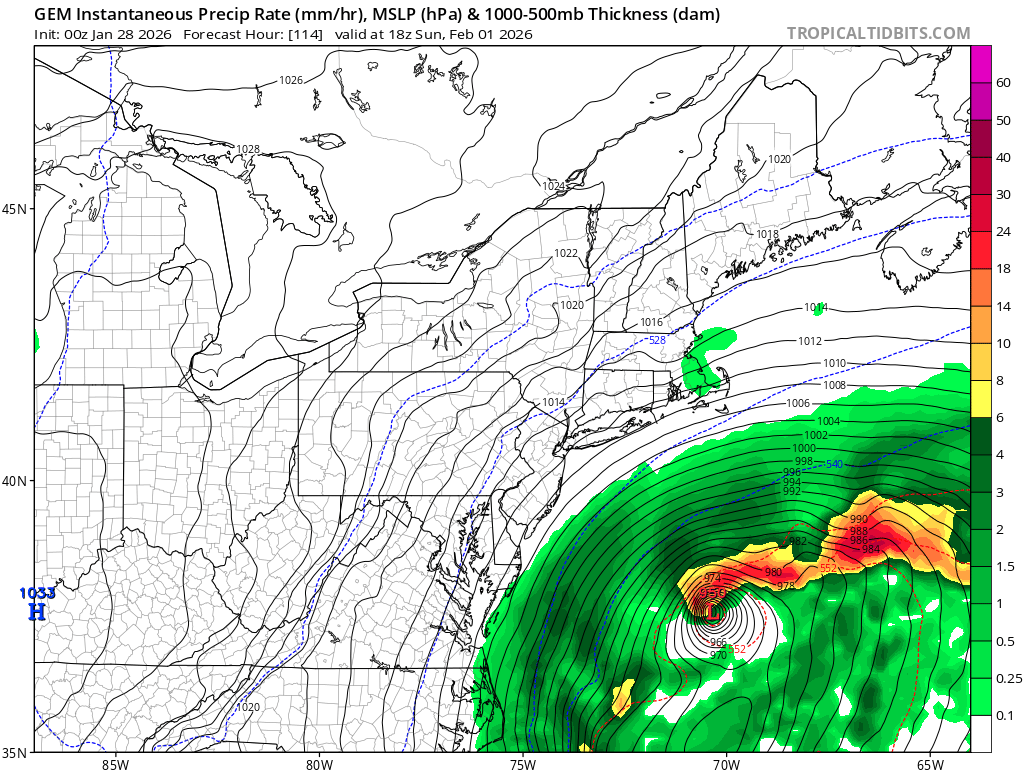
is this good? -
The Jan 31 Potential: Stormtracker Failure or 'Tracker Trouncing
Ji replied to stormtracker's topic in Mid Atlantic
-
The Jan 31 Potential: Stormtracker Failure or 'Tracker Trouncing
Ji replied to stormtracker's topic in Mid Atlantic
GEFS west so far -
The Jan 31 Potential: Stormtracker Failure or 'Tracker Trouncing
Ji replied to stormtracker's topic in Mid Atlantic
lol what happened? -
The Jan 31 Potential: Stormtracker Failure or 'Tracker Trouncing
Ji replied to stormtracker's topic in Mid Atlantic
I would rather me not get 9 if someone gets 40 in NC -
The Jan 31 Potential: Stormtracker Failure or 'Tracker Trouncing
Ji replied to stormtracker's topic in Mid Atlantic
im tossing the cat 3 hurricane
-
The Jan 31 Potential: Stormtracker Failure or 'Tracker Trouncing
Ji replied to stormtracker's topic in Mid Atlantic
yea lol. We didnt know what to eject or what to phase or when to phase or how to phase the eject or if we need a full ejection or partial -
The Jan 31 Potential: Stormtracker Failure or 'Tracker Trouncing
Ji replied to stormtracker's topic in Mid Atlantic
what did you say at 18z. Folks? -
The Jan 31 Potential: Stormtracker Failure or 'Tracker Trouncing
Ji replied to stormtracker's topic in Mid Atlantic
If you look between 0z and 12z you see the huge tick west. Thats where its really noticable -
The Jan 31 Potential: Stormtracker Failure or 'Tracker Trouncing
Ji replied to stormtracker's topic in Mid Atlantic
i think its more than a hair--its like sideburn -
The Jan 31 Potential: Stormtracker Failure or 'Tracker Trouncing
Ji replied to stormtracker's topic in Mid Atlantic
yea hour 42 is def west now. i think it was just a timing issue -
The Jan 31 Potential: Stormtracker Failure or 'Tracker Trouncing
Ji replied to stormtracker's topic in Mid Atlantic
everything is a tick east so far--not sure if its east or timing -
The Jan 31 Potential: Stormtracker Failure or 'Tracker Trouncing
Ji replied to stormtracker's topic in Mid Atlantic
hour 3 is east of 18z -
The Jan 31 Potential: Stormtracker Failure or 'Tracker Trouncing
Ji replied to stormtracker's topic in Mid Atlantic
the cliff -
The Jan 31 Potential: Stormtracker Failure or 'Tracker Trouncing
Ji replied to stormtracker's topic in Mid Atlantic
lol the terrifying trifecta -
The Jan 31 Potential: Stormtracker Failure or 'Tracker Trouncing
Ji replied to stormtracker's topic in Mid Atlantic
if GFS is east----going to be bed. No way the Euro will be better -
The Jan 31 Potential: Stormtracker Failure or 'Tracker Trouncing
Ji replied to stormtracker's topic in Mid Atlantic
yea heights are definitely flatter..... -
The Jan 31 Potential: Stormtracker Failure or 'Tracker Trouncing
Ji replied to stormtracker's topic in Mid Atlantic
same place as GFS but not nearly as amped. -
The Jan 31 Potential: Stormtracker Failure or 'Tracker Trouncing
Ji replied to stormtracker's topic in Mid Atlantic
yea its slower.may not be more west -
The Jan 31 Potential: Stormtracker Failure or 'Tracker Trouncing
Ji replied to stormtracker's topic in Mid Atlantic
doing play by play of the icon? Should we do the JMA too? -
The Jan 31 Potential: Stormtracker Failure or 'Tracker Trouncing
Ji replied to stormtracker's topic in Mid Atlantic
isobars pushing north in that panel -
The Jan 31 Potential: Stormtracker Failure or 'Tracker Trouncing
Ji replied to stormtracker's topic in Mid Atlantic
Well the midday runs sucked ass -
The Jan 31 Potential: Stormtracker Failure or 'Tracker Trouncing
Ji replied to stormtracker's topic in Mid Atlantic
Don’t forget every time this winter we make a step forward we take three back -
The “I bring the mojo” Jan 30-Feb 1 potential winter storm
Ji replied to lilj4425's topic in Southeastern States
Congrats guys. Please share some of the love like we do with you. -
I think you’re just saying that!