

Birds~69
-
Posts
32,335 -
Joined
-
Last visited
Content Type
Profiles
Blogs
Forums
American Weather
Media Demo
Store
Gallery
Posts posted by Birds~69
-
-
8 minutes ago, Ralph Wiggum said:
Ensembles are beginning to highlight the week following Christmas for a favorable pattern for POTENTIAL winter storm evolution.
Front comes thru Christmas morning and associated slp heads towards Nova Scotia and begins to pump a ridge near Southern Greenland over the weekend (east-based -NAO?).
By the time Monday the 28th rolls around there is a blocking pattern established in the NAO region (east?). This is the period to watch (Dec 28-Jan 3) as disturbances head across the country and run into the block. Potential is high based on these looks for one of the disturbances to connect IF the blocky looks continue in the NAO. AO is neutral to slight negative, PNA ridge is trying to pump, Aleutian low is present, and there is a weak split flow off the West Coast. All are favorable teleconnections. Keep in mind this doesn't always yield a storm but these are the drivers that many look for when discussing Northeast winter storm potential.
GEFS is the most aggressive wrt actually honing in on a specific threat


^ "This is the period to watch (Dec 28-Jan 3)"
DT got a bit excited about this time period overnight...
-
Some precip moving up...not sure if it's making it to the ground.(dreaded virga)
26F

-
 1
1
-
 1
1
-
-
1 minute ago, KamuSnow said:
Lol, I thought about it. All we have down here at the moment is coffee and V-8's. But yeah!
May have a little snow early-mid morning tomorrow. Hang outside then w/the coffee...scenic and peaceful.
-
2
-
1
-
-
3 minutes ago, KamuSnow said:
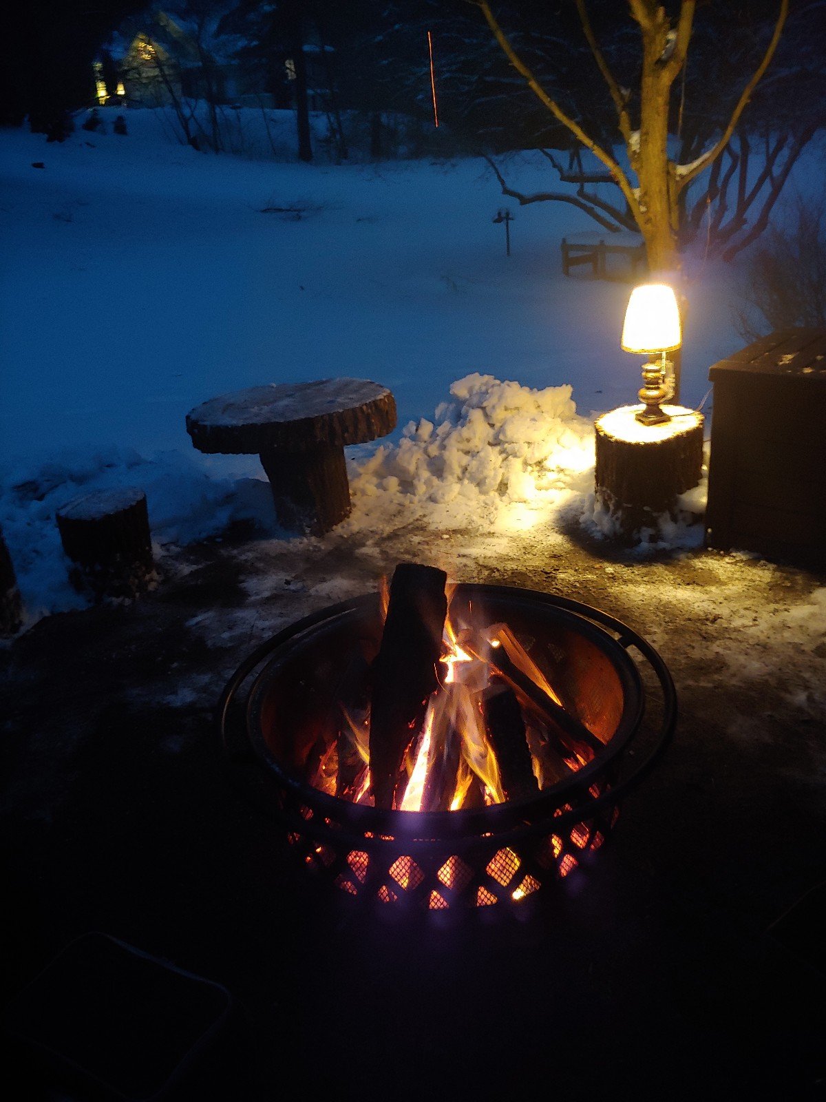
First snow-surrounded kettle fire with the revamped kettle fire area! We don't usually use the lamp but it's cool having power handy....

Looks Great! But you need a whiskey bottle and a half filled glass on the table in the background for the true holiday/winter experience...

-
1
-
1
-
-
11 minutes ago, JTA66 said:
14F this morning.
12z NAM still shows snow showers tomorrow. Nothing much but nice seeing flakes this time of year.
Snow on snow!
27F
-
1
-
1
-
-
2 minutes ago, ChescoWx said:
With a little bit of elevation on a hill we don't radiate so while a couple miles away down at Marsh Creek lake level (400 ft asl) they have had several lows in the teens ...both here at 685 ft asl and at KMQS Coatesville Airport at 660ft we both had our 1st sub-20 day of the season.
That may be it.
I would have thought for sure you had several teen mornings but apparently not.
-
1
-
-
11 minutes ago, ChescoWx said:
1st Teens of the season this AM and first since February 21st - low was 15.9

You seem to keep accurate data but are you sure about first teens of the season?
-
1
-
-
1 hour ago, Animal said:
6 gfs...does not indicate much snow for accumulation. Reading possible severe weather over to snow. Possibly get a dusting. Likely change by early this coming week.
Yeah, doesn't look great. Just have to hope the cold air blast in quicker than expected.
Hit my low of the season (I think?) at 14F
-
6abc(accu weather) 11pm:
Hell. I'll take that progression of cold air mixing stuff 2am Xmas...

-
1
-
-
3 hours ago, Birds~69 said:
Clear skies, snowpack and light winds....looking for my first single digit night or damn close.
22F @ 9:30pm....I have some work to do.

-
3 hours ago, Hurricane Agnes said:
Firefox had announced that any versions after the version that they have been rolling out this week (v84.x), will no longer support Flash, so most browsers have been wrapping up their dropping of support for it it - https://www.mozilla.org/en-US/firefox/84.0/releasenotes/
And apparently Adobe itself is dropping support of it (it has been considered a big security risk and source of all kinds of malware, etc) - https://support.mozilla.org/en-US/kb/end-support-adobe-flash
I remember when "Shockwave Flash" first came out not long after the graphical "web" was getting underway to replace the text-based early web that deployed in the early - mid '90s. There is still a lot of content out there (particularly training stuff) that is still using Flash and I expect it has been difficult for some of the hosts of that material to get it converted to HTML 5 video format (and/or considering whether it is even worth converting if the info has been deprecated and/or updated).
One of the coolest Weather-related flash presentations was the depiction of the type of damage that one might expect with the various hurricane intensities. NHC had embedded it on one of their pages - https://www.nhc.noaa.gov/prepare/hazards.php
Thankfully the creator had put it on YouTube about 5 years ago -
Yeah, I read somewhere over the Summer Flash wouldn't be supported after this year. I think this may catch people by surprise.
I haven't used FF in a couple years. They were my first "go to" browser when they hit the scene but the last time I used it....it was so damn bloated w/crap I wouldn't use. I can't believe they're on version 84. I think I quit in v50's. The early stages of FF was lightning quick.
Ah yeah, Shockwave Flash early years...brings back my youth.
-
4 hours ago, freemenot said:
Yeah, I think they are using some html5 features. Its kind of like a google maps with radar data overlaying it. Myradar app on android (probably iphone also) does same thing but 100x more usable and faster, so I don't think its a technical limitation, more of an implementation problem.
Same here on Android. Best free radar if that's all you need. Loads fast and all...
-
Clear skies, snowpack and light winds....looking for my first single digit night or damn close.
-
4 hours ago, freemenot said:
So looks like new radar interface was pushed out as default for weather.gov (at least for KDIX). Its great that its not using flash, however, it is very very slow for me, forget about zooming in our out, takes like 15 seconds to load radar image on a very fast connection(5ms to google, 900/900mbps connection). Then if you want to see a loop, prepare to wait like 60+ seconds. Is there any tips/tricks to make this faster, or any tools that will use the radar data but make it more usable?
HTML5?
-
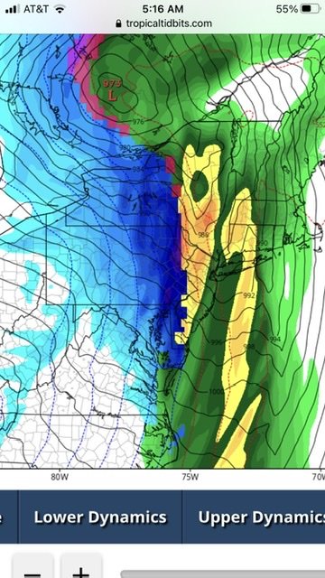
12z GFS
The Christmas eve/day has some potential but still a week away...pretty kick ass cold front either way.
-
1
-
1
-
-
Cecily (accu weather) going wIth/Arctic front blowing through Xmas eve w/rain possibly changing to ice etc...temps 30s for Xmas.. So any holiday blow torch canceled as of now...

-
1
-
-
1 hour ago, wkd said:
What radar app do you use? Reslly liked the images you posted.
It's GRLevel3.
-
Is greenskeeper on strike?
-
 2
2
-
1
-
-
Accu weather weenie Xmas day forecast...

-
3 hours ago, Wentzadelphia said:
Any reports near Bensalem? Curious how they did my brother lives there
5"
-
Light fine snow...may eek out another inch before all is said and done.
25F/breezy

-
Yeah, this is booking out of here pretty quickly...
Sleet / 25F

-
1 minute ago, penndotguy said:
22 with moderate snow it’s back
You have some nice stuff moving in...couple more inches?
-
In the pink, heavy mix, windy and 24F.


E PA/NJ/DE Winter 2020/2021 OBS Thread
in Philadelphia Region
Posted
They're great just chillin out and walking around. They suck doing 65mph and dart in front of you. Nailed one on Rt 422 back in the 90s....scared the bejesus outta me!
26F