

jburns
-
Posts
25,480 -
Joined
-
Last visited
Content Type
Profiles
Blogs
Forums
American Weather
Media Demo
Store
Gallery
Posts posted by jburns
-
-
3 minutes ago, buckeyefan1 said:
You really need a disclaimer weenie tag
Meteoweenist?
-
 2
2
-
-
38 minutes ago, Prospero said:
OK who agrees?
My wish:
Ida gets her eye and RIs into a Cat 5, reaches near the LA coast to justify evacuation but not that bad and shifts east staying offshore bringing fun and excitement to the Florida Gulf coast (not too bad, but thrilling even for Tampa Bay), then moving west to the Texas coast giving everybody a taste there maintaining a perfect eye, then going east through the channel between Cuba and Florida allowing the Keys and Miami to have some fun, up the eastern coast brushing Cape Hatteras intensely (they are used to it, can handle it, and love it) then drifting up the east coast past VA and sitting for a day or so off NJ becoming a Cat 5 sub-tropical Hurricane and slamming NJ so nobody will ever mention Sandy again.
A perfect eye the entire week long adventure.
Right?
")
Finally!! Some actual authentic banter about Ida.

-
1
-
-
19 minutes ago, dseagull said:
The responses to my opinion speak volumes. It was an OPINION. If you wish to censor opinions, feel free to do so, but at least acknowledge that debate leads to progress. Would it be fair to assume that you are progressive? If you censor and ignore opposing viewpoints, how will you ever attain progress? It is quite disturbing that you feel I am to be labeled a climate change denier. I never denied climate change. I simply deny that humans have any "real" effects on such. I'll leave you guys to it. Sorry for offering a professional perspective.
I’ll let this post remain but it is the last one. This is a storm banter thread. This post has nothing to do with the storm and everything to do with politics. I would hate to have to suspend anyone during this event. For the record, any suspensions I do have to issue will end when Ida is declared a remnant low.
-
 3
3
-
-
6 minutes ago, cptcatz said:
Having lived through it as well, it was the worst natural disaster in NYC history. Why would you expect it to not be talked about on a tropical weather forum?
It is brought up every tine there is a hurricane, anywhere. For nine years. At this point it has become the weather forum version of waterboarding.
-
 1
1
-
2
-
-
1 minute ago, SandySurvivor said:
In terms of impact this isn’t going to be nearly of severe impact of something like Sandy.
Im expecting impacts similar to Nate in 2017
We are talking hurricanes here not a post-tropical cyclone.

-
1
-
-
2 minutes ago, kvegas-wx said:
Ah yes, Professor Burns has entered the chat. Thanks for imparting that wisdom Burnsie!
Thanks. If you prefer the blue collar version Mike Tyson said much the same thing in a more direct manner. “Everybody has a plan until they get punched in the mouth.”
-
10
-
3
-
6
-
-
1 minute ago, AChilders said:
Other than the outer fortifications that have been made, the 3 flood gates on the canals through the city from Pontchartrain are the most impressive. That back flow of water from the lake back to the Mississippi River is what caused the breaches in the 17th street canal in 2005. I walked it all in September/October of 2005.
I know. Banter.
I went back after Isaac in 2012. The flood wall was crazy impressive.
now back to storm mode…
The improvements are indeed impressive but there are still unknowns. One of my favorite quotes comes from a 19th century German Field Marshall named Helmuth von Moltke. “No plan of operations extends with certainty beyond the first encounter with the enemy’s main strength.” I tend to hope for the best and prepare for the worst. With all the changes that seem to be happening with our climate I think that might be the best way going forward. It seems to me as if 100 year events are happening every decade.
-
2
-
-
6 minutes ago, JC-CT said:
I mean, makes sense in theory, but...?

That storm is going to take off as soon as it clears the Island.
-
6
-
-
11 minutes ago, NavarreDon said:
Yikes!!!…..
48H 29/1800Z 28.6N 90.6W 120 KT 140 MPH
.Rare for them to forecast that extreme so quickly from what is now a cat 1. I hope people pay attention.
-
7
-
-
35 minutes ago, turtlehurricane said:
The swamp animals are going nuts outside @Prospero it’s the ultimate cacophony. They know a hurricane is brewing near by.
Also saw the full moon rising through outflow cirrus, it’s really cool
Is weather folklore an under graduate or graduate class?
-
3
-
-
33 minutes ago, Windspeed said:
Then for God's sake, why post it? Just, why? For all the reasons x10000000, why post the bloody damn NAM, take it seriously and comment about it? Why do people continue to do this?29 minutes ago, Windspeed said:32 minutes ago, hlcater said:You clearly aren't very familiar with what board you're on.
Oh I am, I just will never understand. I can get people who simply do not know better. But to basically disclaimer it and then post? Grrr...
26 minutes ago, Windspeed said:28 minutes ago, jdj5211 said:That’s why it was disclaimed. It’s a simple post…you can choose to ignore and move on. We have people talking about absolute unrelated nonsense on here….at least it was related to the storm.No, it is 100% misleading and unwarranted if you understand that model's purpose and use. Yet you still posted it. This is on you. Period.
25 minutes ago, Windspeed said:STOP POSTING THE NAM.
kthx.Lighten up Francis.
-
2
-
-
4 minutes ago, nwohweather said:
Should just name this storm Hurricane Lebron with the amount of hype it’s getting. The models and setup are very alarming but still I cannot recall the alarm bells being rang quite like this while still in the TD/low TS stage
We skipped over the usual one full week of a slowly developing storm wandering around the islands. Landfall is expected within three days in a sensitive area so they are cranking up the media quickly. Also there seems to be quite good agreement that this storm is definitely going to landfall in along the mid gulf coast.
-
4
-
-
Let’s start using the storm banter thread for these cute quips.
-
2
-
7
-
 1
1
-
-
-
32 minutes ago, wncsnow said:
I'm afraid what happened in Tennessee today may be even worse than what we dealt with. Just crazy weather
Almost everyday we hear of extreme weather events. It could just be my old memory but they seem to be happening much more frequently and with more severity than in times past.
-
1
-
-
2 hours ago, Sickman said:
I guess we're not in
KansasLong Island any more, Toto...Let me give you one heads up about the south. When Michelle says to you, “bless your heart” that is not a good thing. Welcome.
-
1
-
4
-
-
41 minutes ago, dryslot said:
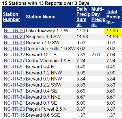
12" totals? I bet there will be lolis to 18", We can always adjust higher if needed................
Lol. Be careful what you joke about. Here are some totals from tropical depression Fred as it moved through Western North Carolina earlier this week.
-
2
-
-
1 hour ago, buckeyefan1 said:
I've been too busy figuring out if I need to leave
 The tornado in Mauldin was a couple of miles away and the one in Fountain Inn was less than 1/4 mile from me. Fun times
In case one gets you make sure you remember all you have to do is click your heels together three times and say, “there’s no place like AmWx”. You’ll be back home in a jiffy.
-
2
-
-
On 8/12/2021 at 3:31 PM, LibertyBell said:
https://twitter.com/i/events/1425823798733856768
Europe is going to eliminate short haul continental airplane trips with super high speed trains- we should be doing this too. Limit airplanes to overseas (literally overseas) travel. Maglev, hyperloop, etc. can use existing rail technology and are zero emission!
We won’t do shit about climate change. Oh, the government might try to implement some changes but I have zero faith that a population that can not even agree to wear a mask during a pandemic will make major changes in their way of life to save the planet.
-
1
-
-
I got 2.52 inches of rain early this morning. Quite a surprise.
-
1
-
-
5 minutes ago, nwohweather said:
Haha A+ for effort. Maybe it's a bit Midwest of me here, but growing up in Ohio we regularly saw severe storms. But a derecho was always a whole different ball game and think they need something to differentiate between your usual severe storm, and the ones where you legit need get in a building. I'll say this, 65 mph is pretty wild stuff but anyone who's seen 90+ can attest that is a hell of an experience.
I agree. Been there and done that.
-
1
-
-
20 minutes ago, nwohweather said:
Good call by the NWS! Any storm with winds 65 knots and higher or extremely large hail is something the public needs to be alerted of immediately. To be honest why not look at potentially having a Severe Thunderstorm Warning, and a Destructive/Extreme Thunderstorm Warning?
Don’t give them ideas. They will come up with something like this.
Marginally Severe
Slightly Severe
Enhanced Severe
Moderately Severe
Real Severe
High Severe
Even Higher Severe
Almost Severest
Severest
Extreme Severest
Even Severester
Off the Charts Severester
-
1
-
2
-
-
1 hour ago, yotaman said:
Been raining all afternoon today and it's been heavy at times. Currently up to 1.22" for the day. Let my husky out front so he could do his thing and the old fart decided to take off, had to chase after him in slip-ons splashing thru the water. Caught him but not after both of us getting soaked.
I’m betting he enjoyed getting soaked a whole lot more than you did.
-
34 minutes ago, NorthHillsWx said:
More action that us, no rain here. Have had some nice cooling outflow breezes
I’m sure but look at my location under that storm. I mean, come-on.
-
 1
1
-

Ida Banter
in Tropical Headquarters
Posted
I died but I didn’t retire.