

nycsnow
-
Posts
3,807 -
Joined
-
Last visited
Content Type
Profiles
Blogs
Forums
American Weather
Media Demo
Store
Gallery
Posts posted by nycsnow
-
-
-
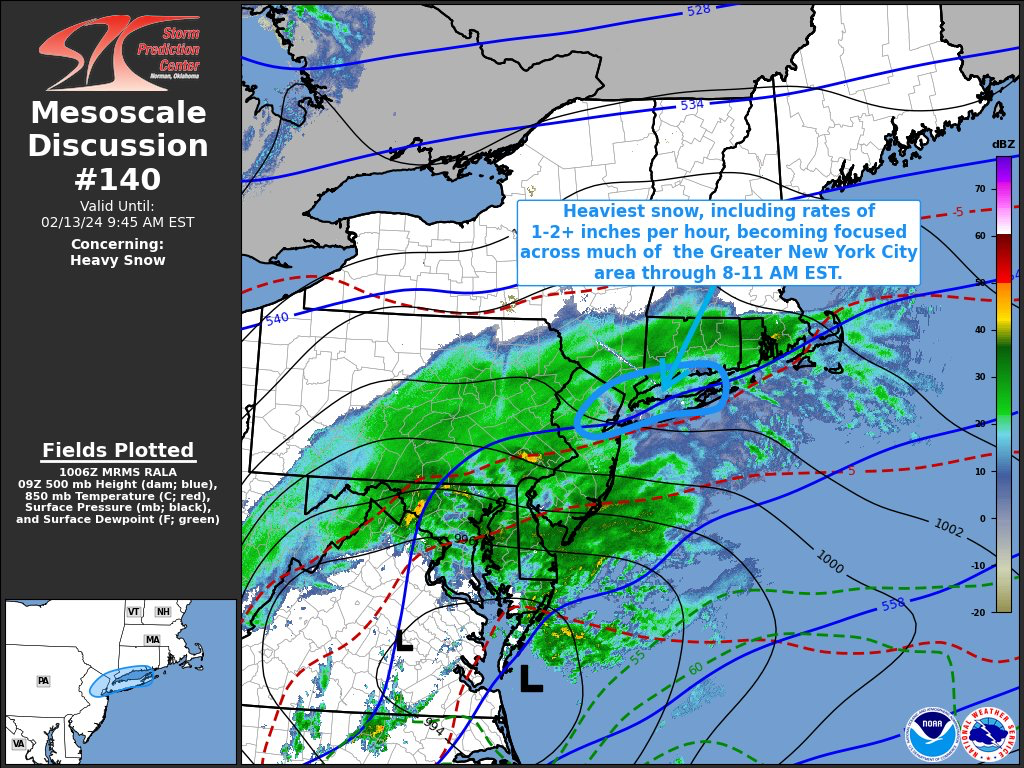
08z hrr increased totals a bit and continues to look better for our friends north. Radar looks great it’s coming
-
 3
3
-
-
2 minutes ago, psv88 said:
Snowing and 33 in Suffolk. Grass and cars covered but roads mostly just wet
Once heavy bands get in should stick everywhere temps def doing better then expected
-
3
-
-
Judging by radar Long Island may get crushed
-
1
-
-
Temps a lot colder then expected across metro and Long Island 32-35 in most places already
-
 2
2
-
-
Solid model runs overnight increased amounts and bumped north and radar looks great
-
2
-
-
1 minute ago, jm1220 said:
Now time for the short range/hi-res models. South trend seems to have stopped on those too and maybe a slight bump back N.
3z hrr rolling
-
1
-
-
CMC coming up next hopefully follows gfs
-
2
-
-
Just now, jm1220 said:
GFS big dynamic banding again with the mid level lows evolving in the perfect spot again.
Let’s see how the rest of nights go and hrr, which has still been bringing 5-8+ for Jersey and nyc metro hopefully this is the new data
-
Gfs is sick and has new data let’s go
-
3
-
-
Gfs is great… can’t post anymore maps said size issue
-
1
-
-
Rgem looked good
-
02z HRR bumped north a bit and has better rates

-
1
-
-
Just now, SnowGoose69 said:
Its been a long time since 12 hours before an event I have told someone NYC or LI is the best spot to be
Still feeling confident? I think NYC has more wiggle room then northern posters I still wouldn’t be surprised if there’s a tick north
-
2 minutes ago, HVSnowLover said:
Often time colder comes with flatter, verbatim still a nice 3-6 inch event but wonder how much sticks if there isn't intense rates.
Nam looks like it does give decent rates not as heavy as previous runs but it’s not light snow
-
Nam hires def better
-
Nam don’t look awful on tidbits
-
00z nam initialized almost matching Spc meso data. Let’s see
-
2 minutes ago, Allsnow said:
Huh?

For the northern posters isn’t it a little more south and the radar don’t bring the heavy band it had last run over metro
-
Hrrr looks eh. Really could use a bump north
-
1
-
-
-
9 minutes ago, SBUWX23 said:
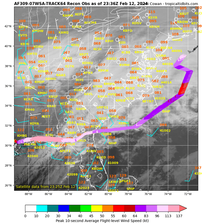
Recon is sampling along the east coast as we speak.

-
2 minutes ago, jm1220 said:
It’ll still be tough in Midtown to accumulate but the colder places in the city look to get crushed. And I think up near I-84 should still be good since there’s very often a northern fronto band with good ratios.
I can see Long Island as a whole doing good as storm blows up more… latest HRR shows that as it engulfs the whole island with a heavy band at hour 18
-
Big band showing up at end of HRR can see the dark blue engulfing

-
1
-


2/13 Significant/Major Winter Storm Discussion & Observations
in New York City Metro
Posted
Radar looks loaded