strongwxnc
-
Posts
6,474 -
Joined
-
Last visited
Content Type
Profiles
Blogs
Forums
American Weather
Media Demo
Store
Gallery
Everything posted by strongwxnc
-
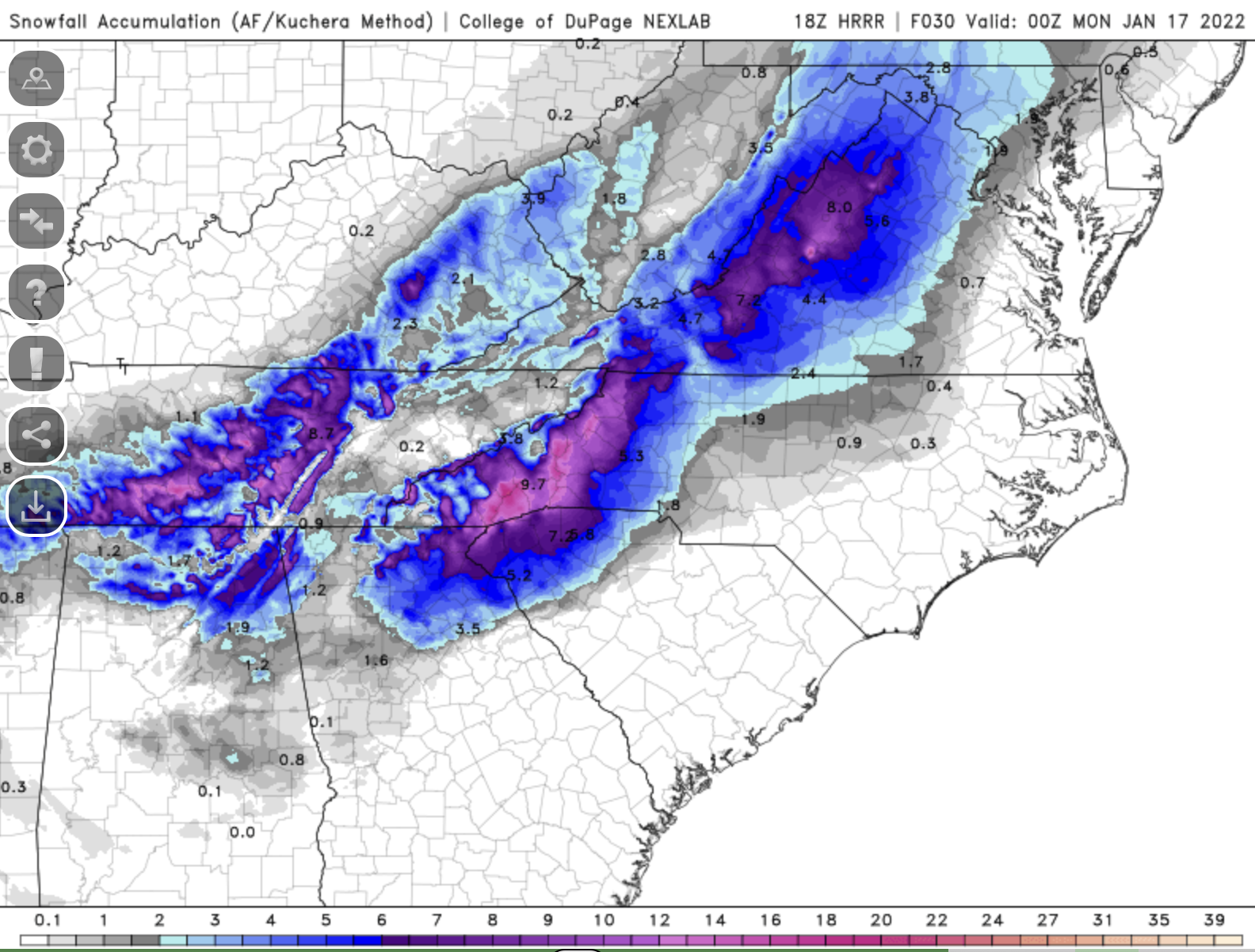
GFS has been constant also with this look. Going to be a fun ride
-

2021-2022 Fall/Winter Mountains Thread
strongwxnc replied to BlueRidgeFolklore's topic in Southeastern States
No doubt!!! Going to be interesting to see totals and how the GFS pans out. Either way, LFG! -
2021-2022 Fall/Winter Mountains Thread
strongwxnc replied to BlueRidgeFolklore's topic in Southeastern States
Sure is. Looks to also delay the mixed bag riding into the upstate and NC. -
2021-2022 Fall/Winter Mountains Thread
strongwxnc replied to BlueRidgeFolklore's topic in Southeastern States
No dread here. Chris was just on before the game starts. -
2021-2022 Fall/Winter Mountains Thread
strongwxnc replied to BlueRidgeFolklore's topic in Southeastern States
Well, I just cracked the first beer. Guess I need to start this early Sorry for the banter. 41.9/30.6 18 HRRR looks good though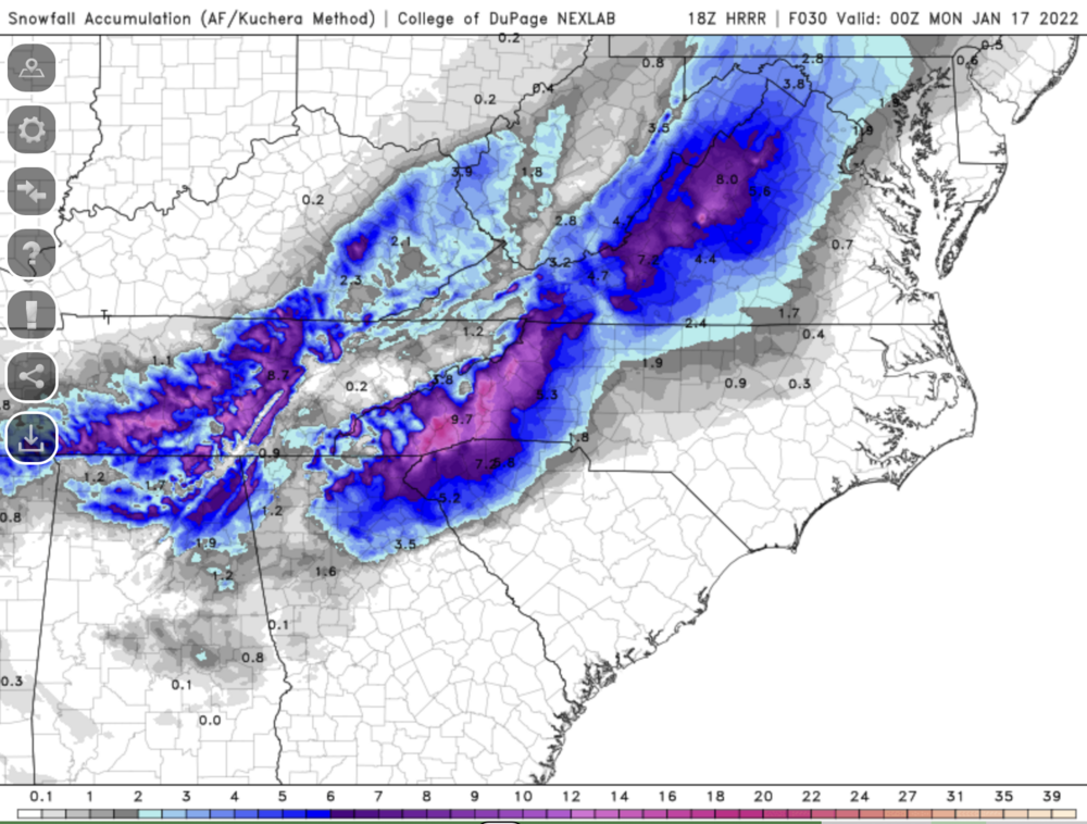
-
2021-2022 Fall/Winter Mountains Thread
strongwxnc replied to BlueRidgeFolklore's topic in Southeastern States
Dropped to around 2" with .1-.3 of ice. NW part of the county dropped to 2-4 total for snow -
2021-2022 Fall/Winter Mountains Thread
strongwxnc replied to BlueRidgeFolklore's topic in Southeastern States
Big hit for sure round here. -
Mid to Long Range Discussion ~ 2022
strongwxnc replied to buckeyefan1's topic in Southeastern States
Would be epic! -
2021-2022 Fall/Winter Mountains Thread
strongwxnc replied to BlueRidgeFolklore's topic in Southeastern States
GSP*** NEAR TERM /THROUGH SUNDAY/... As of 1240 PM EST Saturday: Forecast looks on track for the afternoon. No changes made at this time. -
2021-2022 Fall/Winter Mountains Thread
strongwxnc replied to BlueRidgeFolklore's topic in Southeastern States
Nothing here just yet 41.9/29.4 . -
Winter Storm Izzy Obs Thread
strongwxnc replied to Prismshine Productions's topic in Southeastern States
Awesome ! . -
2021-2022 Fall/Winter Mountains Thread
strongwxnc replied to BlueRidgeFolklore's topic in Southeastern States
Wow! I like that . -
Winter Storm Izzy Obs Thread
strongwxnc replied to Prismshine Productions's topic in Southeastern States
41/20 Winds E . -
2021-2022 Fall/Winter Mountains Thread
strongwxnc replied to BlueRidgeFolklore's topic in Southeastern States
https://www.weather.gov/gsp/ Scroll and click on the tile for winter weather Then scroll to the bottom of that page and you can select by county . -
2021-2022 Fall/Winter Mountains Thread
strongwxnc replied to BlueRidgeFolklore's topic in Southeastern States
Good points by GSP though and looking like a hefty raking of snow for most in this sub thread. -
2021-2022 Fall/Winter Mountains Thread
strongwxnc replied to BlueRidgeFolklore's topic in Southeastern States
No mention of the adjacent foothills areas. -
2021-2022 Fall/Winter Mountains Thread
strongwxnc replied to BlueRidgeFolklore's topic in Southeastern States
Winds between 4-8mph out of the ENE. This is looking N to W . -
Mesowest Is what I use. Just choose Dew point.
-
2021-2022 Fall/Winter Mountains Thread
strongwxnc replied to BlueRidgeFolklore's topic in Southeastern States
-
2021-2022 Fall/Winter Mountains Thread
strongwxnc replied to BlueRidgeFolklore's topic in Southeastern States
Yeah that looks like a stretch. -
2021-2022 Fall/Winter Mountains Thread
strongwxnc replied to BlueRidgeFolklore's topic in Southeastern States
I think we just found a signature statement here! -
2021-2022 Fall/Winter Mountains Thread
strongwxnc replied to BlueRidgeFolklore's topic in Southeastern States
36.1 here http:// https://imgur.com/a/gJpiklB . -
2021-2022 Fall/Winter Mountains Thread
strongwxnc replied to BlueRidgeFolklore's topic in Southeastern States
really hope this warp around comes around -
2021-2022 Fall/Winter Mountains Thread
strongwxnc replied to BlueRidgeFolklore's topic in Southeastern States
About 9 hours of solid snow on this run before changing. -
Saw up here with maybe a few hours later before change over ( mid-late morning) then switching back to snow around 2 Ish Sunday. .