
bearman
-
Posts
512 -
Joined
-
Last visited
Content Type
Profiles
Blogs
Forums
American Weather
Media Demo
Store
Gallery
Posts posted by bearman
-
-
Still dry hear in the Cedar Bluff area of West Knoxville but their is an air of expectation outside.
-
 2
2
-
 1
1
-
-
5 minutes ago, Matthew70 said:
Yep the snow dome is screwing us again. Well this time next week winter is done. 60 less than a week away! Wohoo!
60 is going to be great. I have not been able to get my boat out on the water since I bought it... Time to get out and rip some lips. I am however, going to enjoy whatever we get tonight for some reason I am feeling good about tonight. Maybe it's the Scotch in my hand.
-
8
-
-
For folks in the valley cloud cover proceeding events like this can very good. Trapping cold air in the valley at the surface. It does not always matter but in marginal situations every piece of the puzzle counts. Right now it is not looking very good. Here is a good place to check out cloud cover. https://www.theweathernetwork.com/map/satellite
-
1
-
-
Looks like Memphis is getting its first flakes of round 2. Glad to see them cashing in. Check out the cam.
-
2
-
-
There is one thing that is absolutely clear. MY SKIES in north Knoxville.
-
1
-
-
1 hour ago, Jed33 said:
I remember several years back (would have to look back through the threads here, but it’s here somewhere) where a front end thump was looking to change to rain but it just never did in the eastern valley. In the foothills and mtns it warmed up to nearly 50 degrees, however it stayed in the 20’s to around 30 in the valley and stayed snow the whole time! Ended up with 5.5in at the house and I know some places just north had over a foot! That was about as strange of a situation we could ever expect around here. The thinking was that somehow there was a cold pool aloft over the valley and that the warm nose hit the mtns and just never was able to penetrate back to the west. Extremely rare system indeed.
I remember that event. Rain was suppose to be my predominat Ptype and i ended up with around 2 inches of snow in West Knoxville. North West Knoxville did much better. There were also some Zr if I remember correctly.
-
1
-
-
3 minutes ago, John1122 said:
Honestly the wide variety in modeling that MRX is talking about seems to be the NAM family vs basically every other model.
They do seem to hug the warmest solutions and it does play out well for them often but their term wide seems more of a bias rather than an honest statement.
-
2
-
-
MRX is acting like there will be no front end thump of snow for the valley in the morning disco. They tend to always look the other way when the models say anything about snow chances. Stick fingers in ears. Put hands over eyes. Repeat the mantra, "it never snows in the valley". The unfortunate reality is, it works most of the time.
-
Cheers to a good dump!
-
1
-
-
Check out the elephant cam at the Memphis Zoo. I am sure that water is a little cold for the big pachyderms.
https://www.memphiszoo.org/elephant-cam
-
1
-
 1
1
-
-
12 minutes ago, Sweetpea Farms said:
Sorry, I was watching TV when you posted!
 I'm with you! It can snow all it wants, but ice is bad. We dodged a bullet. I went through a couple ice storms here - worst I think was 1994, we were out of power for 7 days. I've just got my first cup of coffee, but I'm due to dive into the models to see why the heck they predict 5-8 inches of snow here when winds are NN EAST! That sounds ludicrous. But we'll see.
Just curious, Why do you think winds out of the NN East is unusual when getting large snows? I live in the Knoxville area and almost all the large storms i remember have had an east or north east wind component.
-
John I value your insight. Do you think this has a chance to trickle down to the great valley floor? I know it is a hard call but what do you think the chances are? Not that I want that at all. The tempatures continue to be 5 or so degrees colder than forecast on a consistent basis. it seems like a possibility to me..
-
1
-
-
looks like Nashville has now pulled the trigger. I think it was expected.
Winter Storm Watch
URGENT - WINTER WEATHER MESSAGE
National Weather Service Nashville TN
314 AM CST Sat Feb 13 2021

TNZ008>011-027>034-058>066-075-077>080-093>095-131800-
/O.NEW.KOHX.WS.A.0002.210215T0000Z-210216T1200Z/
/O.CON.KOHX.WW.Y.0007.000000T0000Z-210213T1600Z/
Sumner-Macon-Clay-Pickett-Davidson-Wilson-Trousdale-Smith-Jackson-
Putnam-Overton-Fentress-Lewis-Williamson-Maury-Marshall-
Rutherford-Cannon-De Kalb-White-Cumberland-Bedford-Coffee-Warren-
Grundy-Van Buren-Wayne-Lawrence-Giles-
Including the cities of Hendersonville, Gallatin, Goodlettsville,
Lafayette, Celina, Byrdstown, Nashville, Lebanon, Mount Juliet,
Hartsville, Carthage, South Carthage, Gordonsville, Gainesboro,
Cookeville, Livingston, Jamestown, Allardt, Hohenwald, Franklin,
Brentwood, Columbia, Lewisburg, Murfreesboro, Smyrna, La Vergne,
Woodbury, Smithville, Sparta, Crossville, Shelbyville, Tullahoma,
Manchester, McMinnville, Altamont, Coalmont, Spencer, Clifton,
Waynesboro, Lawrenceburg, and Pulaski
314 AM CST Sat Feb 13 2021

...WINTER WEATHER ADVISORY REMAINS IN EFFECT UNTIL 10 AM CST THIS
MORNING...
...WINTER STORM WATCH IN EFFECT FROM SUNDAY EVENING THROUGH LATE
MONDAY NIGHT...

* WHAT...For the Winter Weather Advisory, freezing drizzle,
  freezing fog, and a few patches of light freeing rain.
  Additional ice accumulations of a light glaze. For the Winter
  Storm Watch, heavy mixed precipitation possible. Total snow
  accumulations of 1 to 3 inches and ice accumulations of up to
  two tenths of an inch possible.

* WHERE...Portions of Middle Tennessee.

* WHEN...For the Winter Weather Advisory, until 10 AM CST this
  morning. For the Winter Storm Watch, from Sunday evening
  through late Monday night.

* IMPACTS...Travel could be very difficult.

* ADDITIONAL DETAILS...Although confidence is high that
  significant winter weather will impact the area Sunday night
  through Monday night, the details including exact snow and ice
  amounts are subject to change. Please check back for updates.

PRECAUTIONARY/PREPAREDNESS ACTIONS...

Slow down and use caution while traveling. Prepare for possible
power outages.

Monitor the latest forecasts for updates on this situation.

The latest road conditions for the state you are calling from can
be obtained by calling 5 1 1.

&&

$$
-
1
-
-
Glad the guys out west are getting in on the winter WX. Just hope it can shift into sleet and snow rather than freezing rain. I hate the ZR. if I had my choice between it and a torch i would take the heat.
-
5
-
1
-
-
2 hours ago, Save the itchy algae! said:
Had 3” in Farragut, it’s all gone now.
That is amazing I had around .2 in Cedar Bluff. I do not believe we ever transitioned to all snow all night.
-
1
-
-
This was a flop for me. The radar is dying and I am at at maybe .2 of an inch of wet slop on the grass. I do not think I had snow fall without rain mixed in at any time throughout the night. Congrats to all who saw snow. It would be a miracle if we could get a good general snow for the whole area like i remember as a child. Growing up it happened quite often. It now seems like such an extremely rare event.
-
10 minutes ago, Stovepipe said:
I'm really glad I stayed up for it. Finally transitioned to a full blown fat flaked snow. The real change over happened a little before 2am, MRX said it would start mixing in at 5am. Regardless, I'm grateful!

Wow I must be in the Hot Zone I am back to mostly rain. You know those areas in the city you drive by after you got a good snow and say, Wow they got nothing". Here I am.
-
Been at a rain snow mix for almost an hour But it does seem to be transitioning so I have got to get some sleep. Congrats to all who are getting snow!
-
It is pouring a mix of slop here in Cedar Bluff hopefully it will transition soon.
-
1
-
-
3 minutes ago, bearman said:
Still all rain in West Knox. Hate to waste the precipitation. Maybe a little screaming at the sky will help.

It worked I have some flakege.
-
3
-
-
Still all rain in West Knox. Hate to waste the precipitation. Maybe a little screaming at the sky will help.
-
1
-
1
-
 1
1
-
-
I have been saying that since I was 18 when I developed enough awareness to know it was an obsession, now I am 58. Don't think I am ever going to give it up.
1 minute ago, Kasper said:Oh wait I see a sleet pellet!
-
1
-
-
We need to get over this obsession of waiting for ice crystals to form in the sky. There I said it.
3 minutes ago, Kasper said:Meanwhile 40 miles south it’s Rain

-
1
-
-
Still nothing but a cold rain in West Knox County. I am looking for Stovepipe to start seeing flakes consistently so I know it's near.
February 17-18th Winter Storm Thread.
in Tennessee Valley
Posted
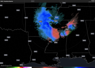
Looks like that area of heavy sleet is about at Sweetwater making its way slowly up the valley. Dry air
fighting it all the way.