

nzucker
-
Posts
10,771 -
Joined
-
Last visited
Content Type
Profiles
Blogs
Forums
American Weather
Media Demo
Store
Gallery
Posts posted by nzucker
-
-
3 hours ago, Isotherm said:
Dew points were quite high most of August through the third week. It was very humid, and most in the Northeast corridor were slightly warmer than normal. While August was slightly cooler departure wise than expected, July compensated. The trimonthly range is most important for long range seasonals (which directly hit). I often debate whether I should even include monthlies, because it's substantially higher difficulty than the already difficult seasonal, and people will tend to myopically focus on any comparatively diminutive error in one of the monthlies.
And the "increasing heat and humidity" was taken a bit out of context. July and August certainly featured increased heat and humidity compared to June, with respect to normal. The assertion in the outlook was that the first 1/3 of summer would be coolest relative to normal with increasing warmth/humidity thereafter, which verified objectively.
I mean overall your forecast was a hit, but the idea of heat returning in the 2nd half of August never really came to pass.
July was an extremely hot month, nearly up there with '55 and '66.
Also, you went a little heavy on 90-degree days; part may be attributable to the vegetation in Central Park.
-
 1
1
-
-
We didn't really have "increasing heat and humidity" in August. I think the month finished +0.3F with 3 days that hit exactly 90F. That's not exactly a warm August.
-
8 minutes ago, NycStormChaser said:27 minutes ago, Snow88 said:It is
No it's not
It's not. I was in the garden tonight and it got dark around 7:45.
-
15 minutes ago, gravitylover said:
Me too. Nearest station to me is under .1 for the week and only .01 today. Still under an inch since mid July unless I'm forgetting something.
I've had almost no rain in the Bronx this August. My neighbor's squash looks crisped.
-
UAH only came in at +0.38C, however, but they tend to run low.
-
No rain at all here in the Bronx. Garden has dried out fast.
-
On 7/12/2019 at 1:40 PM, ORH_wxman said:
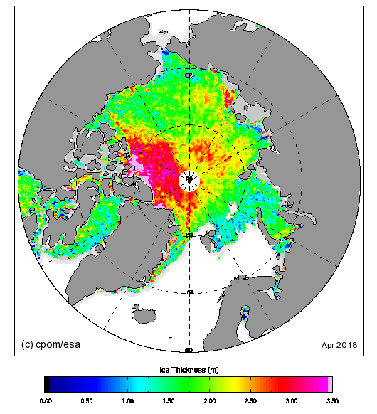
Here's an animation comparing 2019 to 2012 on this date. I think the key to getting a new record is clearly going to be the Laptev/ESS side of the ice. The CAA are Atlantic side of the CAB are running way behind 2012 and those are going to be problems in sustaining the big losses.
Click to animate....

I still think it will be difficult. The ice is much higher concentration this year in the CAB/CAA, and 2012 had so much rotted ice on the Siberian side. This year, it's more just a straight line between ice/no ice.
-
16 minutes ago, LIWeatherGuy29 said:
What's going on there? My dad lives in Dobbs Ferry. No rain on the south shore of long Island yet.
I'm from Dobbs. I grew up on Luzern Rd and my parents still live there. Where in town is your dad?
-
63 and breezy, feels more like early May. Cool start to June, but that's been typical in recent years. Summer heat lingers well into fall but starts out mild.
-
8 hours ago, tamarack said:
Reminds me of when we moved from NNJ to BGR on 1/23/73, anticipating big snowstorms. Dec. 1972 remains their snowiest on record for that month so there was a good pack, but our 1st week in Maine was a thaw. Had a nice 8" dump in late Jan, followed 2 days later by 50° RA that wiped it out completely, and winter was essentially done though we had a 3-day pastefest in late Feb, 9" total while never being more than 4" deep. Then in 73-74 we failed to even approach a 6" storm until one on the equinox, and BGR was contenting for its least snowy winter on record until early April brought a 9" powder event. Only in Dec '75 did we get a double digit wintry storm. Moved to Ft. Kent on 1/1/76, and though we had over 90" in Jan-Feb-Mar there wasn't a storm larger than 8". Not until 76-77 did we see "real" Maine snow.
Ironically, the best period for big storms I've experienced was in NJ. From 3/56 thru 2/61 we had 7 storms in the 18-24" range; nothing I've seen/shoveled since then has approached that super-thump period.
The winter of 60-61 was the snowiest in Dobbs Ferry history with 90". All three major snowstorms were 15"+ there, and the town had 10 straight nights in the single digits.
March 1960 was 32" in Dobbs Ferry.
Jealous you experienced 76-77 in northern Maine. The cold must have been amazing. What was your lowest max and min?
-
On 5/18/2019 at 4:25 PM, tamarack said:
Hope he doesn't get the "Zucker" treatment - taught one year in SW NH, Monadnock country, and anticipated big snow. It was 2011-12 and he saw less than he had the previous 2 seasons in the NY metro (where he's back to.)
Lol yeah...we only got 52" that winter in Rindge. Had 24" in the October bomb and 3" a few days before that. Only saw about 2 feet fall the entire winter at 1200' in the Monadnocks.
Had 68" in 09-10 and 70" in 10-11 in Westchester.
-
 1
1
-
-
On 5/2/2019 at 12:27 PM, ORH_wxman said:
Looks like Cryosat2 is done scanning for the season....based on the prelim results this year, it looks like the Beaufort, Chukchi, and western ESS are thicker than last year, but the eastern ESS and parts of Laptev are thinner.
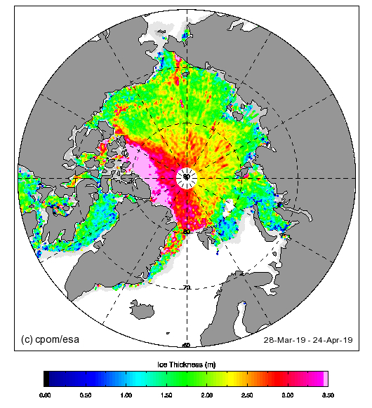
Also looks like significant improvement north of the CAA and Greenland.
-
On 4/19/2019 at 9:25 AM, bluewave said:
November and March were the few times over the last year that we saw the WAR relax. It pretty much ran the table for the DJF resulting in near record low snowfall over that period. Notice how the influence of the Greenland blocking often gets muted under this regime.

Block didn't gain much latitude either.
-
9 minutes ago, doncat said:
Yes it was coldest at my station for 40 years of record.
I had 6" in the 4/2 storm then we just missed 4/9-10.
-
4 hours ago, doncat said:
First week of this April averaged about 6° warmer than last April...You can see the difference in growth this year vs last.
Last April was frigid... the coldest in the CONUS in like 30 years.
-
4 hours ago, donsutherland1 said:
Based on historical climatology, observed ongoing warming, and the latest ensemble guidance, it is very likely that the 32° temperature on March 18 will wind up becoming New York City's (Central Park) last freeze of the season. Given the latest data, this will be the last mention of New York City's final freeze of the winter 2018-19 season.
Outer boroughs like the Bronx experienced freezes well after March 18.
-
1
-
-
Only 41F here in the Bronx, chilly day.
-
5 hours ago, bluewave said:
Slowest start to spring for the entire US since 2014.

The Northern Plains and Northwest have had an incredibly cold February/March. What an historic stretch for that area. I can hardly imagine what Glacier National Park looks like.
-
Just planted arugula and lettuce. Hope it doesn't get snowed on TOO hard.
-
5 hours ago, bluewave said:
The November to March relationship has been pretty tight since 09-10.
NYC
Season...Nov....Mar
18-19.....-3.3.....-2.2...so far
17-18.....-1.1.....-2.4
16-17.....+2.1....-3.3
15-16.....+5.1....+6.4
14-15.....-2.4.....-4.4
13-14.....-2.4......-4.8
12-13.....-3.8......-2.4
11-12....+4.2.....+8.4
10-11.....+0.2.....-0.2
09-10....+3.4.....+5.7
March 2012, I reached 80F at 1200' in Rindge, NH. The next year in NYC, we had two major snowstorms in March. March 2014 was largely snowless but had several days in the 20s while March 2015 carried a 19" snowpack into the month. Amazing the variation one can see in March.
-
34 minutes ago, bluewave said:
There are some hints that our late fall and early spring patterns have become linked. Cooler Marches have generally followed cooler Novembers. Even the snowy and colder pattern this past November was followed up by similar conditions this March to date. The 3 warmest Marches since 2010 have perfectly matched the 3 warmest Novembers.
NYC monthly departures
Nov...2015....+5.1...Mar...2016...+6.4
Nov...2011....+4.2...Mar...2012....+8.4
Nov...2009....+3.4...Mar...2010....+5.7
Two of these were strong +ENSO (although 1997 actually had a cool fall in an east-based Super Niño)...
-
14 minutes ago, bluewave said:
March 2010, 2012, and 2016 will go down as the only early starts to spring during the 2010’s with extreme warmth. All the other years were colder or closer to normal like 2011.
March 2010’s NYC departures
2019....-2.2....so far
2018....-2.4
2017....-3.3
2016...+6.4
2015....-4.4
2014....-4.8
2013....-2.4
2012....+8.4
2011....-0.2
2010....+5.7
March has been a cold month and one of our snowiest in recent years. Four Nor'easters in 2018 plus the April storm; the Mar 2017 storm just missed clobbering the City but was like 10" here and 20-30" in outlying areas. Really enjoying the extended winter, very refreshing and crisp this morning. What do you think of the Day 10 threat, any legs? The SOI dip and Phase 3 MJO does seem to have the cold anchored back in the east with some very low heights to our north in Canada.
-
12 minutes ago, Snow88 said:
Maybe a chance of frozen precip next week ?
I think there's a chance...models have been showing that EPO block and window just past the equinox for a while now. We often see the final snowfall of the season around the equinox.
-
1
-
1
-
-
On 3/16/2019 at 7:02 PM, uncle W said:
so far NYC has 65 days with a minimum temperature 32 or lower...last year had 69 with two in April...this week the predicted lows in the city are near freezing Sunday to Wed. mornings...if that happens this year will tie last year...the most in recent years is 93 in 2014-15...2015-16 and 2016-17 had less than 50 such days...37 is the lowest total on record set in 2011-12...before the 1950's there were many years with at least 100 days with a minimum 32 or lower...
NYC reached freezing last night. I think tonight is a lock, probably upper 20s.
My Summer Outlook 2019 VERIFICATION
in New York City Metro
Posted
I like the looks of a weak Niña, warm NP, and low solar activity.
How is ozone and strat temps?