GrandmasterB
-
Posts
805 -
Joined
-
Last visited
About GrandmasterB

Recent Profile Visitors


-

Central PA Winter 25/26 Discussion and Obs
GrandmasterB replied to MAG5035's topic in Upstate New York/Pennsylvania
That’s a wrap for me unless we get a significant storm to track. Easily a B+ winter in my book. Early season cold in December, sustained cold throughout, lots of tracking, the 12” storm in late Jan, plus some big near misses. I’m glad to have this community to share the ups and downs of winter tracking and looking forward to starting another season in October. I hope everyone enjoys the warm season! -B. Bundy -
Central PA Winter 25/26 Discussion and Obs
GrandmasterB replied to MAG5035's topic in Upstate New York/Pennsylvania
HRRR still looks fine for Lancaster. I’ve never been a fan of it but I’m assuming it has utility. -
Central PA Winter 25/26 Discussion and Obs
GrandmasterB replied to MAG5035's topic in Upstate New York/Pennsylvania
If my kids have school tomorrow I won’t be able to show my face around the house. -
Central PA Winter 25/26 Discussion and Obs
GrandmasterB replied to MAG5035's topic in Upstate New York/Pennsylvania
Looks like a nice band rotating up from MD into the York area. It will be interesting to get some obs when that comes up. I wouldn’t spike any footballs just yet. Could still be some surprises. Coastal not even out of the OBX area yet. -
Central PA Winter 25/26 Discussion and Obs
GrandmasterB replied to MAG5035's topic in Upstate New York/Pennsylvania
Someone remind me about what could go wrong today. -
Central PA Winter 25/26 Discussion and Obs
GrandmasterB replied to MAG5035's topic in Upstate New York/Pennsylvania
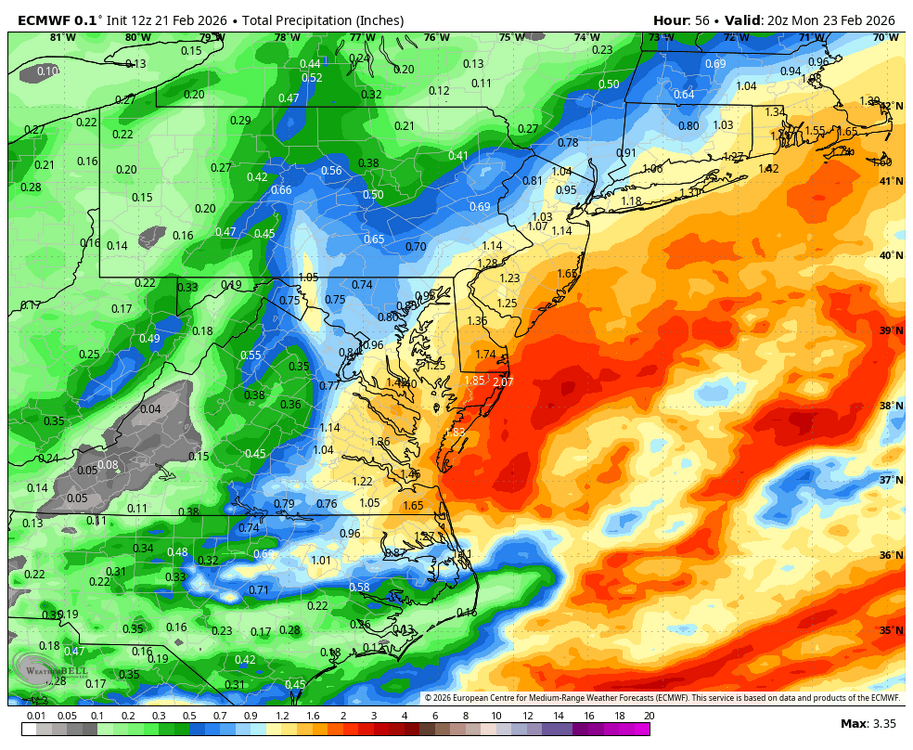
This is basically MU’s snow map -
Central PA Winter 25/26 Discussion and Obs
GrandmasterB replied to MAG5035's topic in Upstate New York/Pennsylvania
Could certainly end up that way, just have to let the chips fall at this point. -
Central PA Winter 25/26 Discussion and Obs
GrandmasterB replied to MAG5035's topic in Upstate New York/Pennsylvania
During the day tomorrow any light or moderate precip not from the IVT or heavy coastal influence will be difficult to accumulate on roads. We really need to be under the slim IVT, the heavier coastal precip, or precip at night to accumulate. That’s been pretty well modeled and outlined by NWS and others. -
Central PA Winter 25/26 Discussion and Obs
GrandmasterB replied to MAG5035's topic in Upstate New York/Pennsylvania
A hair west and better precip vs. 12Z. All I care about at this point. Same for RGEM. -
Central PA Winter 25/26 Discussion and Obs
GrandmasterB replied to MAG5035's topic in Upstate New York/Pennsylvania
ICON a hair stronger and further west. Low position is very close to the MD coast. -
Central PA Winter 25/26 Discussion and Obs
GrandmasterB replied to MAG5035's topic in Upstate New York/Pennsylvania
I just trolled him on X. I’m not proud of it but he rubs it in our face when storms miss. -
Central PA Winter 25/26 Discussion and Obs
GrandmasterB replied to MAG5035's topic in Upstate New York/Pennsylvania
I’m waiting for that one classic NAM run right before the event. Could be happy hour. -
Central PA Winter 25/26 Discussion and Obs
GrandmasterB replied to MAG5035's topic in Upstate New York/Pennsylvania
Still a ton of lows west. Almost on the shore! -
Central PA Winter 25/26 Discussion and Obs
GrandmasterB replied to MAG5035's topic in Upstate New York/Pennsylvania
Stolen from MA. Blizz probably has better maps for us.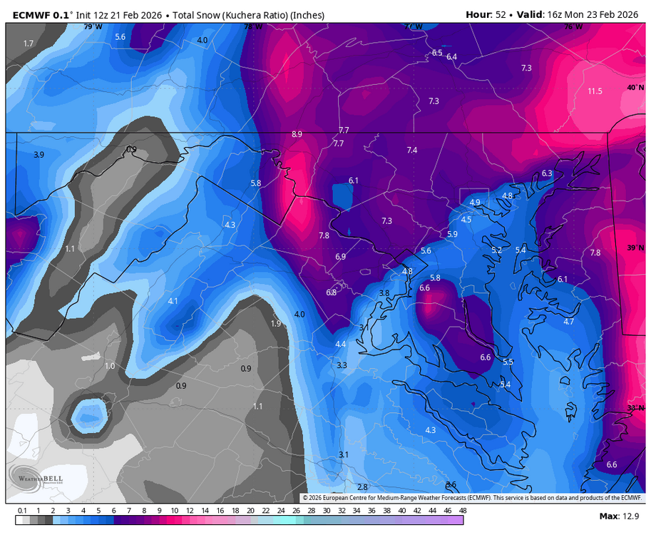
-
Central PA Winter 25/26 Discussion and Obs
GrandmasterB replied to MAG5035's topic in Upstate New York/Pennsylvania
This should make 3-6 very doable.