Jns2183
-
Posts
5,851 -
Joined
-
Last visited
Content Type
Profiles
Blogs
Forums
American Weather
Media Demo
Store
Gallery
Everything posted by Jns2183
-
Central PA Winter 25/26 Discussion and Obs
Jns2183 replied to MAG5035's topic in Upstate New York/Pennsylvania
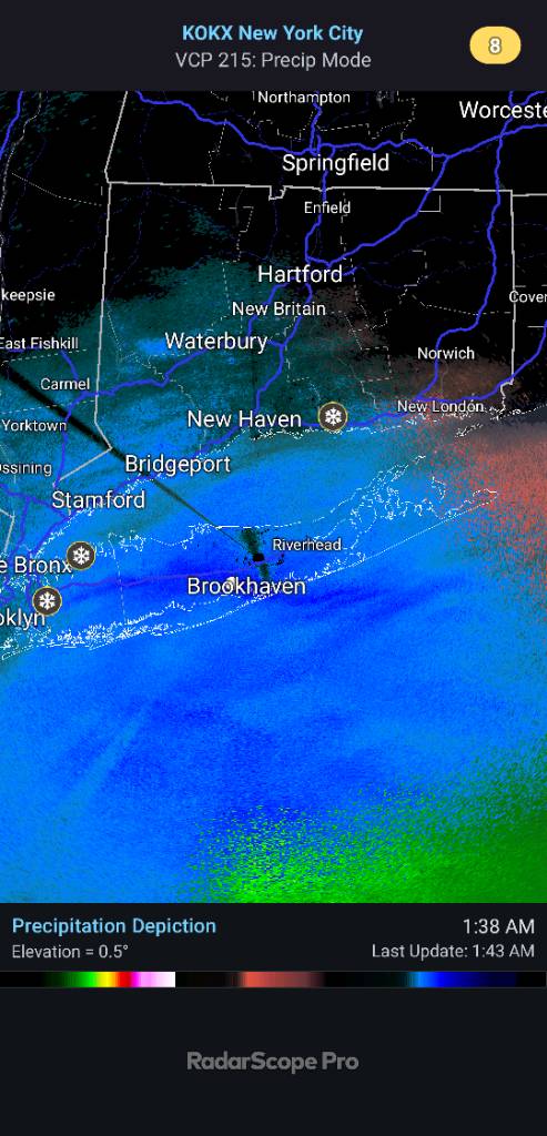
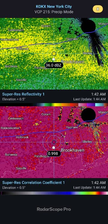
36dbz snow at 29-30 degrees is easy 1.5"-2" an hr. That band has been hitting same area past 2 hours. Wouldn't be surprised to see 4"+ readings, maybe 6"+:if it keeps up another hour. Not a single advisory, bulletin, hazardous weather, etc. Talk about hitting a jackpot. Sent from my SM-S731U using Tapatalk.thumb.jpg.a0e1a3120847bd04e13d3a4b60f110a3.jpg)
-
Central PA Winter 25/26 Discussion and Obs
Jns2183 replied to MAG5035's topic in Upstate New York/Pennsylvania
Long Island is getting slammed, with absolutely no snow in the forecast. Sent from my SM-S731U using Tapatalk
-
Central PA Winter 25/26 Discussion and Obs
Jns2183 replied to MAG5035's topic in Upstate New York/Pennsylvania
Schyukhill county has some areas 2"-4" Sent from my SM-S731U using Tapatalk -
Central PA Winter 25/26 Discussion and Obs
Jns2183 replied to MAG5035's topic in Upstate New York/Pennsylvania
Snow in camp Hill Sent from my SM-S731U using Tapatalk -
Central PA Winter 25/26 Discussion and Obs
Jns2183 replied to MAG5035's topic in Upstate New York/Pennsylvania
Mixing all the way down to Baltimore Sent from my SM-S731U using Tapatalk -
Central PA Winter 25/26 Discussion and Obs
Jns2183 replied to MAG5035's topic in Upstate New York/Pennsylvania
More wind charts Sent from my SM-S731U using Tapatalk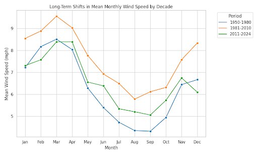
-
Central PA Winter 25/26 Discussion and Obs
Jns2183 replied to MAG5035's topic in Upstate New York/Pennsylvania
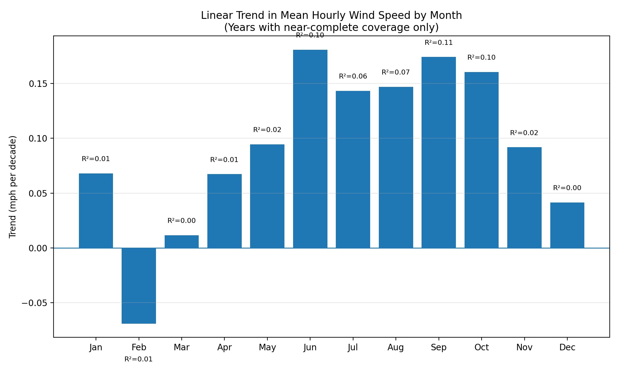
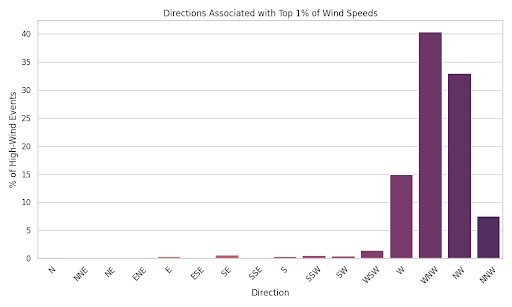
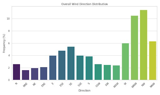
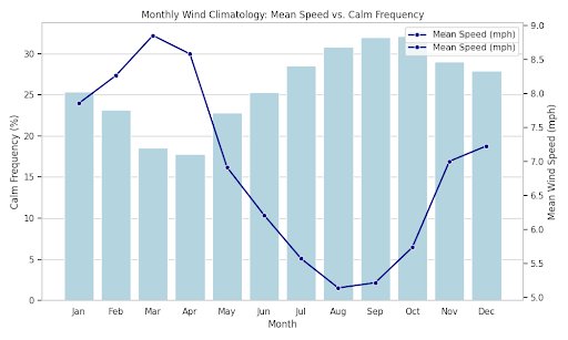
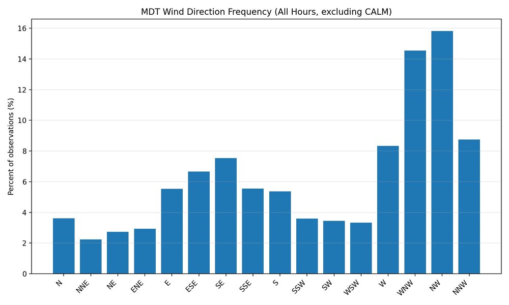
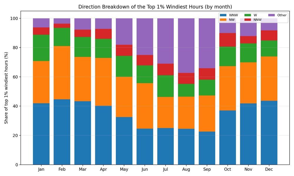
@canderson this is for you buddy. I analyzed wind over the past 90 years. The biggest issue is reliable hourly wind gust data isn't available until the mid-90s. But Bottom line Mean sustained winds: slightly up (tiny trend, noisy). Top 1% sustained winds: slightly up (even noisier). Gusts: “mean gust” trends are not trustworthy without adjusting for measurement practice changes; extreme gusts look mostly steady. Quantity vs speed: quantity is basically flat; any change is more “speed nudge” than “more windy hours.” the key nerd truth: gust trends are extremely sensitive to “are we comparing apples to apples” (instrument/reporting regime). So I ran it two ways: 1) Modern period, all years available (1996–2024) This uses all years in 1996–2024, but note gust/peak-gust availability varies a lot year to year. What the raw trend says (per decade): Mean sustained speed: –0.65 mph/decade (R²≈0.31) Top 1% sustained speed (P99): –1.18 mph/decade (R²≈0.28) Mean hourly gust: –1.16 mph/decade (R²≈0.21) Top 1% hourly gust (P99): –2.99 mph/decade (R²≈0.20) Mean “peak gust within hour”: –0.49 mph/decade (R²≈0.13) Top 1% peak gust (P99): –1.12 mph/decade (R²≈0.05) Interpretation: those big negative trends are a flashing red sign for reporting/instrumentation mix effects, not “Harrisburg winds are collapsing.” So we do the sane thing… --- 2) “Apples-to-apples” subset: years with consistent gust coverage (2008–2024) I restricted to years where gust and peak-gust are recorded a lot (so the metric isn’t biased by selective missingness). That leaves 2008–2024 (14 years). Intensity trends (mph per decade) Mean sustained speed: +0.13 mph/decade (R²≈0.05) → basically flat Top 1% sustained speed (P99): –0.75 mph/decade (R²≈0.09) → basically flat/noisy Mean hourly gust: +0.87 mph/decade (R²≈0.33) → modest upward signal Top 1% hourly gust (P99): +0.84 mph/decade (R²≈0.06) → weak/noisy Mean peak gust: –0.08 mph/decade (R²≈0.00) → flat Top 1% peak gust (P99): +0.98 mph/decade (R²≈0.05) → weak/noisy Quantity trends (frequency; percentage-points per decade) Computed as “of gust observations that exist, what % exceed threshold”: Hourly gust frequency: Gust ≥30 mph: +4.23 pp/decade (R²≈0.28) Gust ≥40 mph: +0.80 pp/decade (R²≈0.08) Peak-gust-within-hour frequency: Peak ≥40 mph: –1.48 pp/decade (R²≈0.03) → flat/noisy Peak ≥50 mph: +0.62 pp/decade (R²≈0.12) → weak/noisy Interpretation: In the most consistent era, the cleanest “signal” is more frequent ≥30 mph gusts (quantity), while the top 1% intensity is mostly noisy/flat. Sustained hourly speed looks basically flat. --- Your “Speed or quantity?” question — answered For sustained winds: neither intensity nor frequency screams “up.” It’s mostly flat in the consistent-era view. For gusts: the best-supported change is quantity (more ≥30 mph gusts), while “top 1% intensity” is not robust (too noisy + sensitive to measurement definition). If you want, I can tighten this even further by: using seasonal bins (DJF/MAM/JJA/SON) for gust thresholds (often cleaner than annual), and/or using percentiles computed from a fixed reference period (e.g., define “top 1%” using 2008–2014 and apply it to all years) so “top 1%” doesn’t move just because the distribution shifts. Sent from my SM-S731U using Tapatalk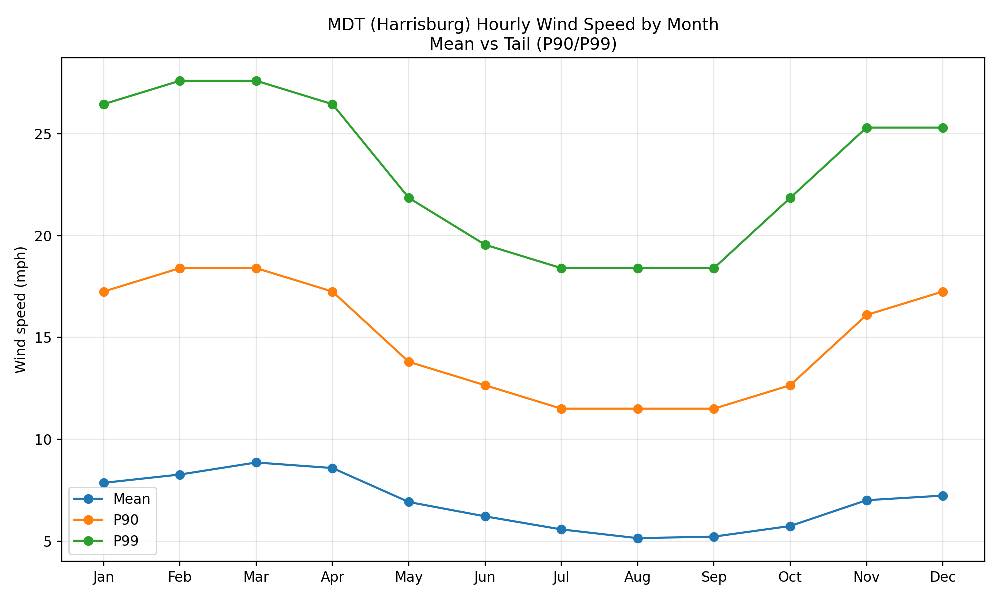

-
Central PA Winter 25/26 Discussion and Obs
Jns2183 replied to MAG5035's topic in Upstate New York/Pennsylvania
This seems to be setting up a frigid march Sent from my SM-S731U using Tapatalk -
Central PA Winter 25/26 Discussion and Obs
Jns2183 replied to MAG5035's topic in Upstate New York/Pennsylvania
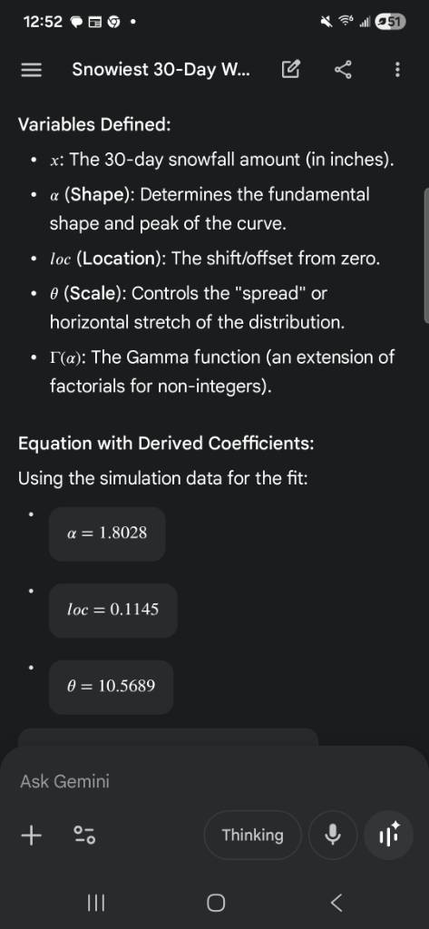
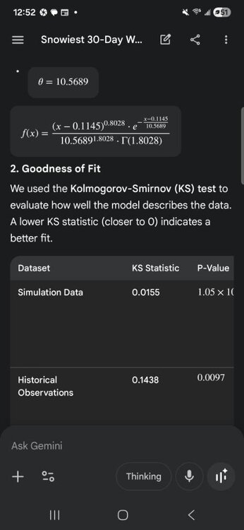
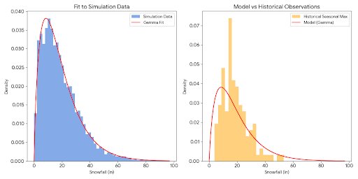
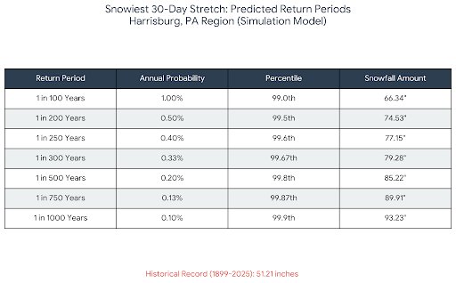
So Sam Lilo did a ridiculous million winter simulation to try to quantify what Boston experienced that fabled 30 day stretch in 2015 when 90+ inches fell in 30 days. Reaching a conclusion it was a 1:26000 year event. I did similar for Harrisburg based upon 125 years data and 30,000 simulation years. Based on the analysis of the simulation data (max30_histogram_bins_0p25.csv) and the historical seasonal maxima calculated from the Harrisburg records, the Gamma Distribution remains the best-fitting mathematical model. 1. The Model: Gamma Distribution The Gamma distribution is ideal for modeling physical quantities that are always positive and exhibit a "heavy tail" (skewed towards high values), such as extreme snowfall events. Variables Defined: * x: The 30-day snowfall amount (in inches). * \alpha (Shape): Determines the fundamental shape and peak of the curve. * loc (Location): The shift/offset from zero. * \theta (Scale): Controls the "spread" or horizontal stretch of the distribution. * \Gamma(\alpha): The Gamma function (an extension of factorials for non-integers). Equation with Derived Coefficients: Using the simulation data for the fit: * * * 2. Goodness of Fit We used the Kolmogorov-Smirnov (KS) test to evaluate how well the model describes the data. A lower KS statistic (closer to 0) indicates a better fit. | Dataset | KS Statistic | P-Value | Interpretation | |---|---|---|---| | Simulation Data | 0.0155 | 1.05 \times 10^{-6} | Excellent Fit. The model follows the simulation counts almost perfectly across the entire range of values. | | Historical Observations | 0.1438 | 0.0097 | Moderate Fit. The model generalizes the history but over-predicts low-snow years and under-predicts the mid-range "typical" snowiest months. | 3. Analysis * Simulation vs. Model: The Gamma curve is a near-perfect approximation of the simulation data. It successfully captures the rapid rise in probability between 0 and 10 inches and the long, thin tail extending past 60 inches. * Historical Gap: As shown in the right-hand graph, the historical observations are more "clumped" than the model predicts. In reality, Harrisburg has a very strong peak of seasonal maxima between 15 and 25 inches. The model (derived from simulation) peaks slightly earlier (around 10 inches). * Extreme Tails: The simulation model is much "bolder" than the historical record. It suggests a non-zero probability of 30-day periods exceeding 80 inches, whereas the historical record (spanning ~126 years) has never surpassed ~51 inches. * Conclusion: The equation is a highly reliable model for the theoretical distribution of 30-day snowfall. However, if used to predict a typical winter in Harrisburg, it will slightly underestimate the "average" peak snow month while significantly overestimating the potential for unprecedented "megastorms." Sent from my SM-S731U using Tapatalk
-
Central PA Winter 25/26 Discussion and Obs
Jns2183 replied to MAG5035's topic in Upstate New York/Pennsylvania
Subject: 90 Years of Harrisburg (MDT) Hourly Weather — Full Deep Dive (1935–2025) Alright everyone, stuck at home in bed I went down the rabbit hole so you don’t have to. I pulled the entire hourly MDT dataset from 1935 through March 30, 2025 — roughly 701,600 hourly observations spanning just over 90 years. This wasn’t a daily summary skim. This was raw hourly temperature, dewpoint, precipitation, visibility, and related fields. Before I even looked at stats, I did cleanup and QC because raw long-term station data is messy: --- Data Cleaning & Methodology 1. File scope Period: Feb 1935 – Mar 2025 ~701,594 hourly bins Observations normalized to hourly resolution (multiple obs per hour consolidated) 2. QC steps Removed physically impossible dewpoints (e.g., below −80°F artifacts) Filtered obvious temperature spike errors (one 60°F+ 6-hour swing in 2013 was clearly a glitch) Precipitation analysis restricted to hours where precip reporting was valid (so “missing” ≠ “dry”) For daily metrics (high/low, freeze dates, heat streaks), only days with sufficient hourly coverage were used Snow depth largely unavailable in this dataset (only ~200 total depth entries), so snow retention metrics were excluded This gives us a dataset that is physically realistic and trend-consistent. --- The Results Absolute Extremes Coldest hour: −22°F (Jan 21, 1994 at 12:00) Hottest hour: 105°F (July 23, 1991 at 20:00) That’s a 127°F total observed range at MDT. --- The “Weather Whiplash” Award Largest temperature swings (QC’d): Largest 6-hour warm-up: +39.96°F (March 31, 1943) Largest 6-hour cool-down: −43.02°F (March 1, 1937) Classic Mid-Atlantic frontal violence. --- Longest Deep Freeze Continuous ≤32°F streak: 398 consecutive hours Jan 19 – Feb 4, 1961 ~16.6 straight days below freezing Runner-up: Dec 25, 2017 – Jan 9, 2018 (363 hours) So yes — modern winters can still lock in. --- Freeze–Thaw Chaos Index I counted crossings of 32°F in winter (Nov–Mar). Most chaotic winter: 1941 (188 crossings) Modern median winter: ~60 crossings That’s a real structural shift in winter volatility. --- Heat Wave Persistence (Daily-Based) Consecutive days with highs ≥90°F: Longest streak: 16 days (July 26 – Aug 10, 1983) Next longest: 15 days (July 1955) Hourly streaks don’t tell the real story because nights cool. Days do. --- The “Swamp Index” Defined as: Temp ≥90°F AND Dewpoint ≥70°F Total oppressive hours in record: 2,348 Top oppressive years: 1952 (92 hours) 1959 (87) 1949 (84) 1991 (83) Mid-century humidity was not subtle. --- Fog / Visibility Shift Hours with visibility ≤1 mile: Total: 22,368 hours ≤0.25 mile (“pea soup”): 4,860 hours By decade: 1940s–50s: ~5–6% of hours ≤1 mile 2000s–2020s: ~1.5–1.7% That is a massive drop. Possible contributors: Instrument changes Air pollution regulation Land use changes Reporting practices But the decline is statistically obvious. --- “Perfect Weather” Hours Defined as: 65–75°F Dewpoint 45–55°F No precip Visibility ≥10 miles Total perfect hours: 4,484 Best months by frequency: 1. September 2. June 3. May July is loud. September is elite. --- Precipitation Extremes Largest 1-hour precip: 4.27" (July 23, 2017) Wettest 24-hour day (reliable coverage): 16.29" (Oct 11, 2013) Wettest 72-hour total: 22.66" ending Sept 8, 2011 Those 72-hour numbers are hydrologically serious. --- Dry Spells Longest continuous dry streak (with reporting active): 286 hours Oct 20 – Nov 1, 2024 ~11.9 days Longest continuous rain streak: 33 hours (Oct 16–17, 2009) --- “Most Normal” vs “Most Weird” Year I computed daily mean deviations from long-term day-of-year climatology. Lowest RMSE (most “boring” year): 2019 Highest RMSE (most structurally weird year): 1967 1967 wasn’t just warm or cold — it was off-pattern. --- Structural Climate Signals (The Interesting Part) Comparing 1936–1959 vs 2000–2024: Diurnal Temperature Range Early period: 17.94°F average daily range Modern period: 16.36°F Change: −1.58°F Days and nights are less swingy now. Night vs Day Warming Mean daily minimum change: +2.64°F Mean daily maximum change: +1.07°F Nights warming more than days is a classic humidification / greenhouse signature. Dewpoint Drift +0.79°F increase in daily mean dewpoint Combine: Warmer nights Slightly higher dewpoints Reduced diurnal range That suggests a shift toward a more moisture-retentive boundary layer and fewer extreme radiational cooling setups. --- Growing Season Length Using freeze date methodology: Earliest first fall freeze: Oct 16, 1939 Latest first fall freeze: Nov 13, 2024 Longest growing season: 233 days (2024) Shortest: 158 days (1983) Typical: ~203 days The envelope is expanding. --- Big Takeaways 1. The 1940s–1960s were much foggier and had more freeze–thaw volatility. 2. The 1980s still dominate heat wave duration. 3. Extreme precipitation events are clustered in the 2000s–2010s. 4. Nights have warmed faster than days. 5. Diurnal range compression is measurable. 6. Dewpoints are nudging upward. 7. Growing season envelope has widened. This isn’t just “it’s warmer now.” It’s structural atmospheric behavior shifting. When looking at rainfall data I can tell hourly amounts are off. It seems to summing partial hour and hourly readings, basically double counting. See below Based on the weather data for Harrisburg (Middletown), the highest 3-day precipitation total on record is 15.11 inches. This historic rainfall occurred from June 21 to June 23, 1972, primarily due to the impact of Hurricane Agnes. The daily breakdown for that period was: * June 21, 1972: 5.81 inches * June 22, 1972: 9.13 inches * June 23, 1972: 0.17 inches * Total: 15.11 inches For comparison, the next highest 3-day total was 11.05 inches in September 2011, during the flooding from Tropical Storm Lee. Sent from my SM-S731U using Tapatalk -
Central PA Winter 25/26 Discussion and Obs
Jns2183 replied to MAG5035's topic in Upstate New York/Pennsylvania
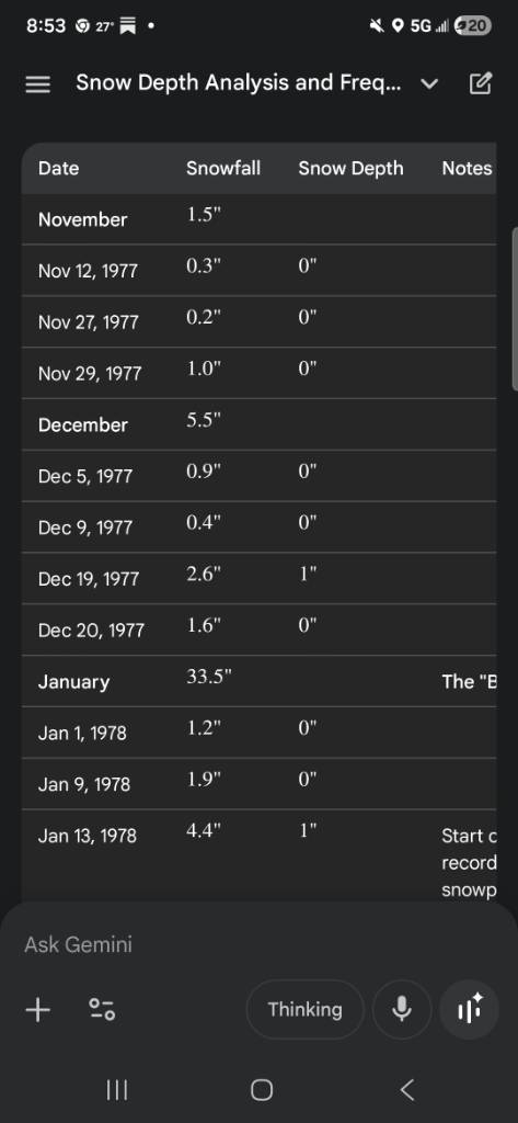
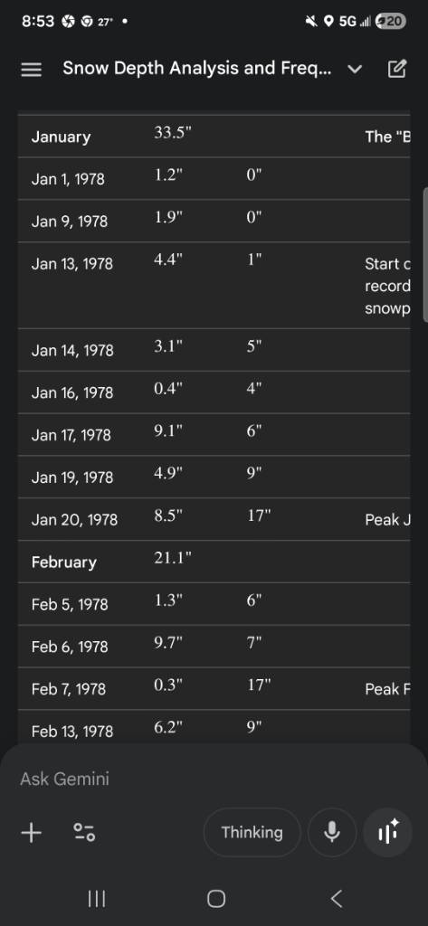
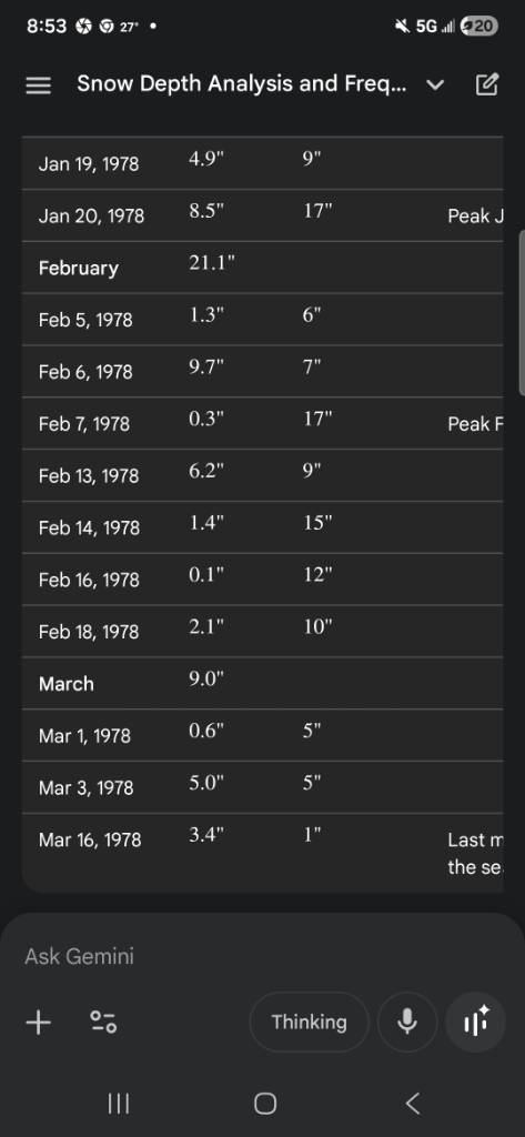
Winter of 93-94 holds the record here. 76 days straight of snow on the ground. Jan 4th to March 20. 1977-78 was also a banger. 66 days straight. Jan 13- March 19th. Take a look at the images for the beauty that winter was. It was also frigid. Average daily temperature Dec 31.6 Jan 26.2 Feb 22.8 March 38.6 Sent from my SM-S731U using Tapatalk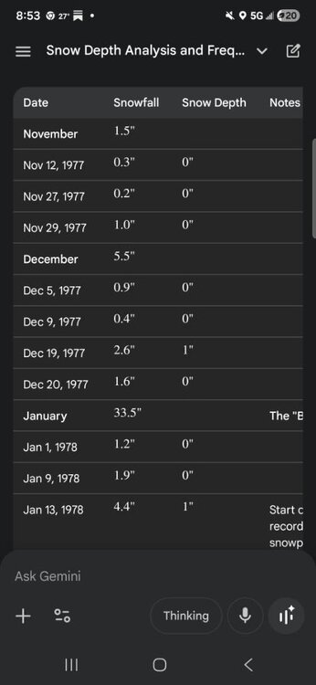

-
Central PA Winter 25/26 Discussion and Obs
Jns2183 replied to MAG5035's topic in Upstate New York/Pennsylvania
At this point I have to laugh. I'm starting to feel better but noticed I couldn't taste anything today. Took COVID test, positive of course. I'm sure I picked that up in hospital Sent from my SM-S731U using Tapatalk -
Central PA Winter 25/26 Discussion and Obs
Jns2183 replied to MAG5035's topic in Upstate New York/Pennsylvania
We are doomed as a species Sent from my SM-S731U using Tapatalk
-
Central PA Winter 25/26 Discussion and Obs
Jns2183 replied to MAG5035's topic in Upstate New York/Pennsylvania
50/50 chance we have a 50/50 chance of having a workable forcast for Sunday night by Sunday morning Sent from my SM-S731U using Tapatalk -
Central PA Winter 25/26 Discussion and Obs
Jns2183 replied to MAG5035's topic in Upstate New York/Pennsylvania
We might as well get the #drought moniker going. I fear this could be the year we truly bake under the vine come summer, with full water restrictions everywhere and the bit. It's been 20 years, we are certainly due and this winter looks to be setting it up perfectly. I hope I eat a big fat crow on this one vs praying for a tropical system to save us. Sent from my SM-S731U using Tapatalk -
Central PA Winter 25/26 Discussion and Obs
Jns2183 replied to MAG5035's topic in Upstate New York/Pennsylvania
I want to make it known just how rare these past 19 days have been. KMDT has had snow on the ground since 1/25. Adding up snow depths we get 111" or an average of 5.84"; but never more than 9". When looking at the past In the last 126 years of data, this specific "steady but deep" condition has only occurred in 4 winter seasons: 1905 1925 1961 1968 Usually to get to 19 days requires a big boy storm. This has been a throwback winter in a way. Sent from my SM-S731U using Tapatalk -
Central PA Winter 25/26 Discussion and Obs
Jns2183 replied to MAG5035's topic in Upstate New York/Pennsylvania
A bunch of meteorologists online have a total crash out this week regarding the total unreliability of weather models this winter (cough cough MU). You think him being a professional meteorologist he would understand this is a known result of blocking / big Rossby-wave amplitude patterns in weather models. We just haven't had to deal with it much recently. Sent from my SM-S731U using Tapatalk -
Central PA Winter 25/26 Discussion and Obs
Jns2183 replied to MAG5035's topic in Upstate New York/Pennsylvania
At this point I just pray for the dryness to stop. I don't care of it's rain, I just want 5-10" of qpf Sent from my SM-S731U using Tapatalk -
Central PA Winter 25/26 Discussion and Obs
Jns2183 replied to MAG5035's topic in Upstate New York/Pennsylvania
I could only work up the energy for a cursory glance. I also was just damn happy to be out of one of Dante's circles. Sent from my SM-S731U using Tapatalk -
Central PA Winter 25/26 Discussion and Obs
Jns2183 replied to MAG5035's topic in Upstate New York/Pennsylvania
The cough was ridiculous. I was on brink of tears when I went in. Turns out I had coughed so hard I ended up with a rib fracture. I also never knew morphine was a cough suprresant either. Sent from my SM-S731U using Tapatalk -
Central PA Winter 25/26 Discussion and Obs
Jns2183 replied to MAG5035's topic in Upstate New York/Pennsylvania
Sorry I haven't been posting much. I came down with worse pneumonia I ever had. Had to spend 2 days at Hershey medical due my oxygen levels crashing. Now I'm just so damn tired. Sent from my SM-S731U using Tapatalk -
Central PA Winter 25/26 Discussion and Obs
Jns2183 replied to MAG5035's topic in Upstate New York/Pennsylvania
It is showing returns but I look up to see blue sky Sent from my SM-S731U using Tapatalk -
Central PA Winter 25/26 Discussion and Obs
Jns2183 replied to MAG5035's topic in Upstate New York/Pennsylvania
I was worried about this exact dryness when looking at the long range right after our storm. It seems to be a theme the last few years that outside 1 maybe 2 incredibly wet months each year we have solidly been dry to very dry most months. It's not really fun praying for a deluge or tropical system every year just for the hope of being somewhat below normal. I miss the 2010's dearly Sent from my SM-S731U using Tapatalk -
Central PA Winter 25/26 Discussion and Obs
Jns2183 replied to MAG5035's topic in Upstate New York/Pennsylvania
In the grand theater of the weather forum, your narcissism steals the show, proclaiming every raindrop a personal tribute, pity the audience can't applaud over the sound of your thunderous self-praise Sent from my SM-S731U using Tapatalk -
Central PA Winter 25/26 Discussion and Obs
Jns2183 replied to MAG5035's topic in Upstate New York/Pennsylvania
This doesn't even feel like jacket weather. Yesterday afternoon wearing anything but a heavy sweatshirt felt like overkill Sent from my SM-S731U using Tapatalk
.jpg.1d28329e7fabdb4d8cbb2340e2396062.jpg)