-
Posts
5,678 -
Joined
-
Last visited
Content Type
Profiles
Blogs
Forums
American Weather
Media Demo
Store
Gallery
Everything posted by Jns2183
-

Central PA Winter 25/26 Discussion and Obs
Jns2183 replied to MAG5035's topic in Upstate New York/Pennsylvania
Look at the satellite water vapor images in western Canada. That high is hauling ass down and that might be why Sent from my SM-S731U using Tapatalk -

Central PA Winter 25/26 Discussion and Obs
Jns2183 replied to MAG5035's topic in Upstate New York/Pennsylvania
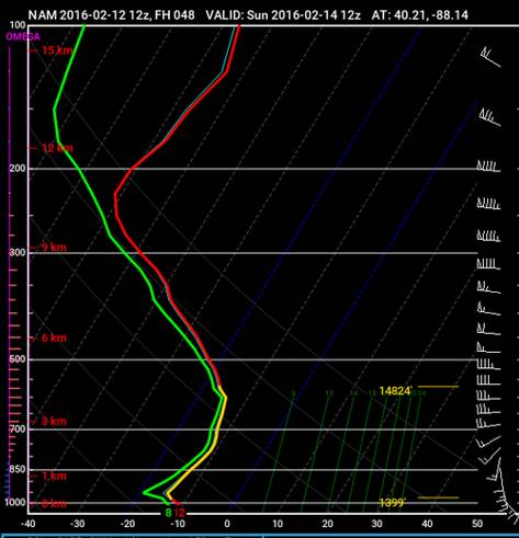
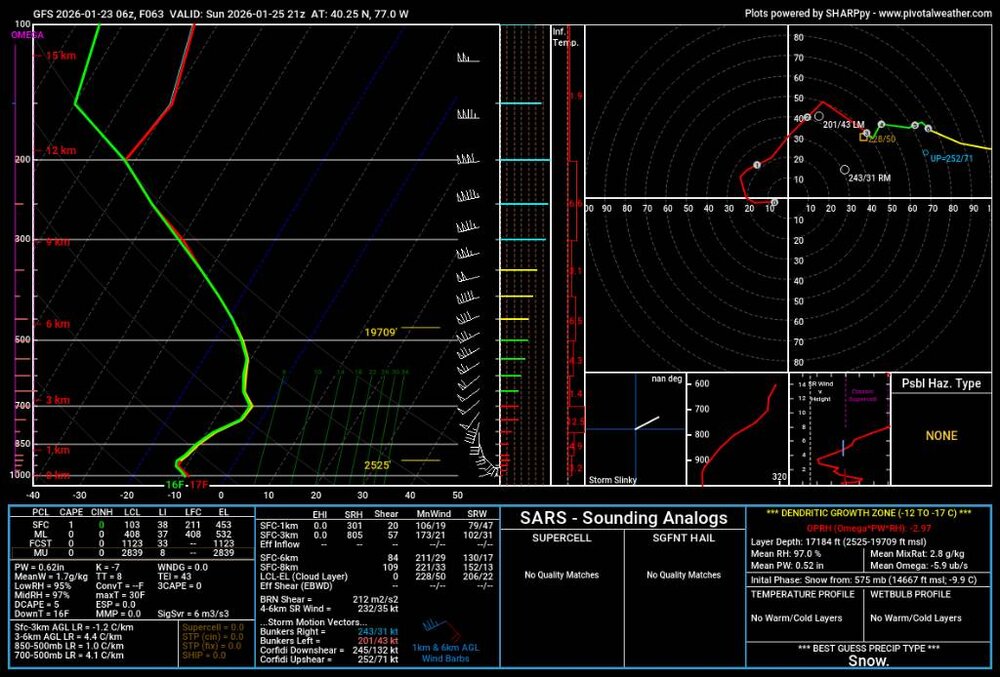
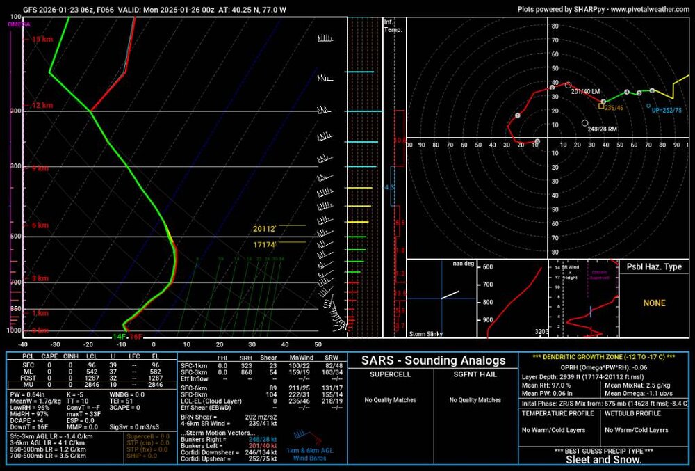
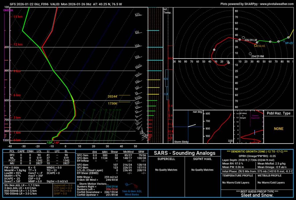
We aren't getting steep lapse rates within the dgz (thunder snow!) that can easily overcome a small dgz, this storm. Our rates are maxed when we get a huge dgz with good accent and lapse rates above it. Compare image used to show this (1st) with that one from the GFS when rates are great. Sent from my SM-S731U using Tapatalk -

Central PA Winter 25/26 Discussion and Obs
Jns2183 replied to MAG5035's topic in Upstate New York/Pennsylvania
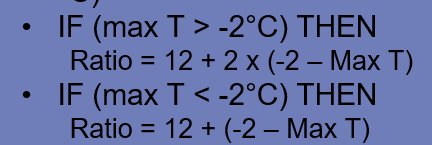
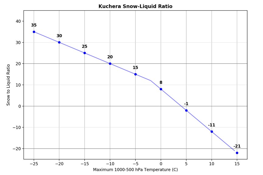
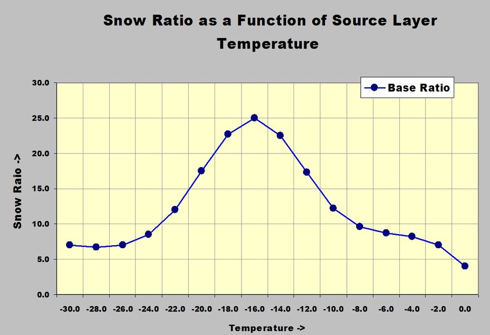
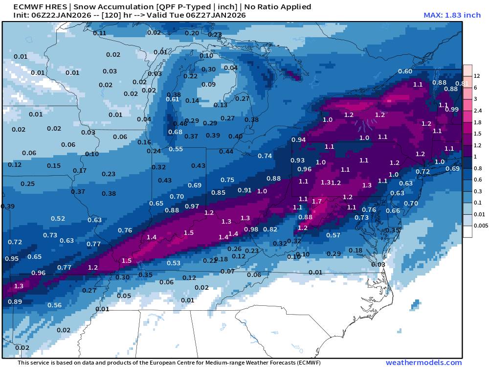
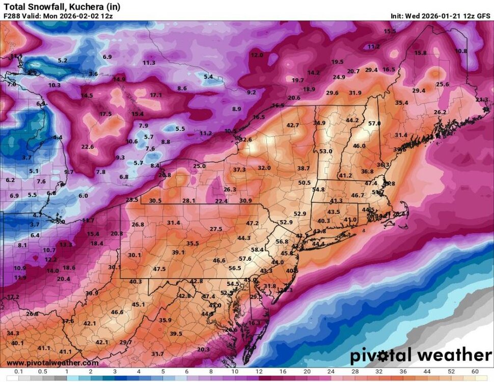
Great summary Im definitely leaning towards a 50/50 blend right now When we're staring at model snowfall maps for the next storm, you'll often see options like the plain old 10:1 ratio (10 inches of snow per 1 inch of liquid) or the Kuchera method, which a lot of sites use because it's supposed to be smarter. The Kuchera approach looks at the warmest temperature anywhere in the atmospheric column (usually up to about 18,000 feet) and plugs it into a formula to tweak the ratio. If that max temp is really cold (say below about -2°C or 28°F), it can spit out fluffy ratios well above 10:1—sometimes 20:1 or more—while warmer columns drop it down toward 5:1 or even lower to account for denser, wetter snow or partial melting. It's a quick way to adjust totals without needing super detailed soundings, and it often gives higher accumulations than straight 10:1 in cold-air setups.But here's the catch that a lot of amateurs (and even some pros) overlook: Kuchera basically ignores the dendritic growth zone (DGZ), that magic layer between roughly -12°C and -18°C where those big, starry, branching snowflakes form best. Those dendrites trap tons of air and stack up super fluffy (high ratios like 15:1–30:1+), especially when the whole layer stays saturated and deep. Kuchera just keys off the single warmest temp in the column, so it can seriously underestimate snowfall in setups with a nice, cold, deep DGZ even if the column max isn't ultra-frigid, or overestimate in marginal/warm cases. Next time you're comparing maps, check model soundings for how beefy that -12° to -18°C layer looks Sent from my SM-S731U using Tapatalk -

Central PA Winter 25/26 Discussion and Obs
Jns2183 replied to MAG5035's topic in Upstate New York/Pennsylvania
My biggest concern is the alignment of when we have truly thick dendritic growth zone to when we have the best omega Sent from my SM-S731U using Tapatalk -

Central PA Winter 25/26 Discussion and Obs
Jns2183 replied to MAG5035's topic in Upstate New York/Pennsylvania
Big Jan 96 vibes with the multiple storms and artic cold Sent from my SM-S731U using Tapatalk -

Central PA Winter 25/26 Discussion and Obs
Jns2183 replied to MAG5035's topic in Upstate New York/Pennsylvania
-

Central PA Winter 25/26 Discussion and Obs
Jns2183 replied to MAG5035's topic in Upstate New York/Pennsylvania
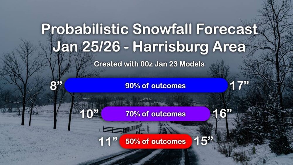
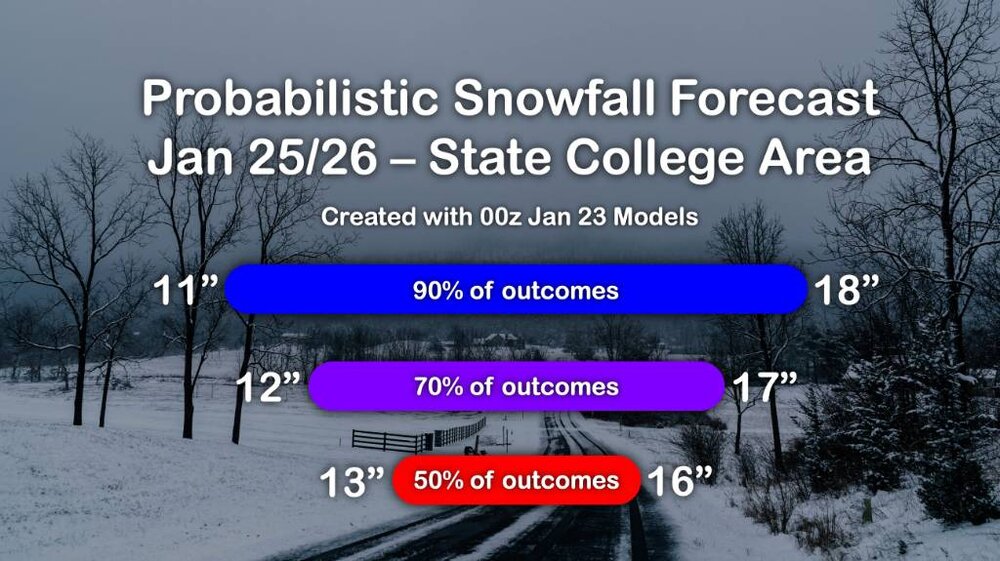
After the epic storm drought we've had I think it would take us getting less than 7" for me to feel slightly jibbed. I do think now we end up in the 12"-14" range much more than 16"-18" range it won't affect my enjoyment Sent from my SM-X210 using Tapatalk -

Central PA Winter 25/26 Discussion and Obs
Jns2183 replied to MAG5035's topic in Upstate New York/Pennsylvania
It's still 15-17_ Sent from my SM-S731U using Tapatalk -

Central PA Winter 25/26 Discussion and Obs
Jns2183 replied to MAG5035's topic in Upstate New York/Pennsylvania
GFS had all 12 of new drops the hurricane hunters did today. The new Euro will as well Sent from my SM-S731U using Tapatalk -

Central PA Winter 25/26 Discussion and Obs
Jns2183 replied to MAG5035's topic in Upstate New York/Pennsylvania
-

Central PA Winter 25/26 Discussion and Obs
Jns2183 replied to MAG5035's topic in Upstate New York/Pennsylvania
If this wasn't starting so damn early Sunday I'd say a few here could handle the game with beer provided double or triple aren't in the name. Sent from my SM-S731U using Tapatalk -

Central PA Winter 25/26 Discussion and Obs
Jns2183 replied to MAG5035's topic in Upstate New York/Pennsylvania
Which Harrisburg station (CBS?) was the one whose January 2016 forcast for Harrisburg as the Storm started was confidently 8-12" (I think NWS was 12" or 16" to 20") kept showing map for awhile even after we surpassed it quickly from waa alone. New guy came in early morning, put up map with 24"+ without comment next to the radar loop of that stationary 60 mile wide band full of yellow that hadn't budged as it was maturing over us and just went with it? Sent from my SM-S731U using Tapatalk -

Central PA Winter 25/26 Discussion and Obs
Jns2183 replied to MAG5035's topic in Upstate New York/Pennsylvania
17.5" Sent from my SM-X210 using Tapatalk -

Central PA Winter 25/26 Discussion and Obs
Jns2183 replied to MAG5035's topic in Upstate New York/Pennsylvania
Mdt 17" Sent from my SM-S731U using Tapatalk -

Central PA Winter 25/26 Discussion and Obs
Jns2183 replied to MAG5035's topic in Upstate New York/Pennsylvania
Weather world today about our big recent snow drought Sent from my SM-S731U using Tapatalk -

Central PA Winter 25/26 Discussion and Obs
Jns2183 replied to MAG5035's topic in Upstate New York/Pennsylvania
Still not sure, but the nam sent me in search of raw bufkit data. I did find that for faw 18z NAM data that the a few hours with sleet but God it was only between 25mb for most and barely a degree above freezing. I'm skeptical. My eyes also hurt from that shit Sent from my SM-S731U using Tapatalk -

Central PA Winter 25/26 Discussion and Obs
Jns2183 replied to MAG5035's topic in Upstate New York/Pennsylvania
-

Central PA Winter 25/26 Discussion and Obs
Jns2183 replied to MAG5035's topic in Upstate New York/Pennsylvania
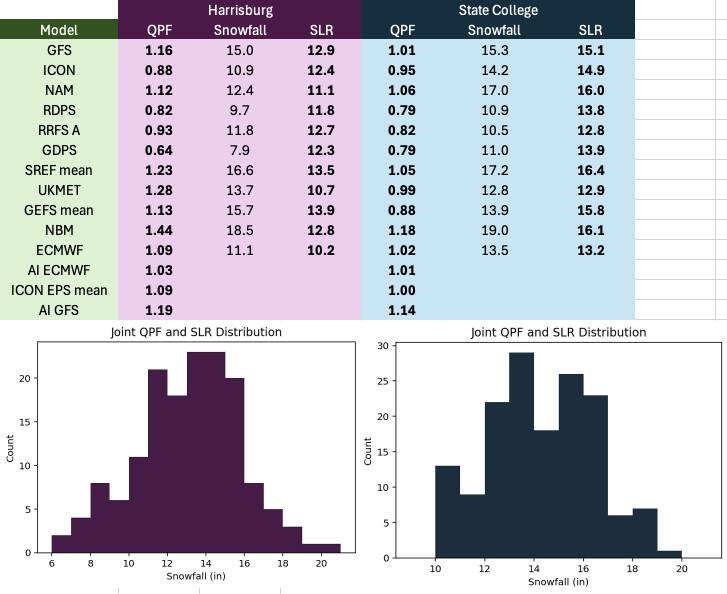
17.5" on the 1.45" qpf from NBM IS 12:1 Ratio If we hit 15:1 it's 22" To make top 10 we have to break 15" 7 is 17.5" 5 is 20" 3 is 22.2 (blizzard of 96) Sent from my SM-S731U using Tapatalk -

Central PA Winter 25/26 Discussion and Obs
Jns2183 replied to MAG5035's topic in Upstate New York/Pennsylvania
Rarely have I ever seen them start with snowfall amounts about 75% percentile from 1300NBM guidance Ratio ratios ratios Sent from my SM-S731U using Tapatalk -

Central PA Winter 25/26 Discussion and Obs
Jns2183 replied to MAG5035's topic in Upstate New York/Pennsylvania
I was looking at the 700/850 frontogensis from 6z GFS and they have little islands of life piping at random it appears at time except for concentration just off show. I'm used to seeing them more crazy underrated. Would love to hac what's going on explained. Sent from my SM-S731U using Tapatalk -

Central PA Winter 25/26 Discussion and Obs
Jns2183 replied to MAG5035's topic in Upstate New York/Pennsylvania
Look to bottom right at initial phase then look at skew-t. I'm utterly confused how initial phase is not snow Sent from my SM-S731U using Tapatalk -

Central PA Winter 25/26 Discussion and Obs
Jns2183 replied to MAG5035's topic in Upstate New York/Pennsylvania
I laughed reading this this morning . Entry 1: Pre-Storm Panic Start Date and Time: Friday, January 23, 2026, 06:00 AM End Date and Time: Friday, January 23, 2026, 11:30 AM The Weenie's Diary: "OMG OMG OMG IT'S HAPPENING. F06 GFS IS IN AND IT'S A MONSTER. THE VIRGA BOMB IS PRIMED. I'VE BEEN UP FOR 72 HOURS STRAIGHT REFRESHING TROPICALTIDBITS AND MY EYES ARE BLEEDING BUT I DON'T CARE. THE DEWPOINTS ARE CRATERING, THAT MEANS THE EVAPORATIVE COOLING IS GOING TO BE EPIC. WE'RE GOING TO BOMB OUT THE COLUMN AND THEN IT'S GAME OVER FOR THE NWS SNOW MAPS. MY BUNKER IS STOCKED WITH 40 POUNDS OF PIZZA ROLLS AND 12 CASES OF MOUNTAIN DEW. IF THIS DRY SLOT RUINS IT I SWEAR I'M GOING TO THROW MY MONITOR THROUGH THE WINDOW. #SNOWMAGEDDON #MODELHUGGER #NOSLEEP #NEEDMORECAPE" Attenborough's Commentary: Here we see the 'Apex Weenie' in the very early stages of a model run cycle. His behavior is characterized by extreme agitation and a fundamental misunderstanding of atmospheric physics. He observes a profoundly dry atmospheric column—a massive impediment to snowfall—and interprets it as a sign of an impending 'bomb'. He correctly identifies evaporative cooling but vastly overestimates its speed and underappreciates the sheer volume of moisture required to saturate such a dry air mass. His use of terms like 'CAPE' in a winter storm context further reveals his confusion, a classic display of the Dunning-Kruger effect in the wild. He is building a psychological castle on a foundation of virga. Entry 2: The "Thump" & The Golden Cross Start Date and Time: Saturday, January 24, 2026, 06:00 PM End Date and Time: Sunday, January 25, 2026, 02:00 AM The Weenie's Diary: "HOLY MOTHER OF GOD. LOOK AT THE MIDNIGHT RUN. LOOK AT IT. IT'S THE GOLDEN CROSS. THE DGZ IS THICKER THAN MY SKULL AND THE OMEGA IS OFF THE CHARTS NEGATIVE. THIS ISN'T SNOW, THIS IS A WHITE OUT OF HISTORIC PROPORTIONS. WE ARE GOING TO RIP 5 INCH PER HOUR RATES. THE RATIOS ARE GOING TO BE LIKE 30:1, IT'S GOING TO BE PURE FLUFF. I'M GOING OUTSIDE NAKED TO MEASURE IT. THE NAM WAS RIGHT ALL ALONG, ALL HAIL THE NAM. THE EURO IS TRASH. I TOLD YOU ALL ON THE FORUMS, I CALLED THIS SIX DAYS AGO WHEN IT WAS JUST A GLINT IN THE GFS'S EYE. NOBODY LISTENED TO ME. WHO'S LAUGHING NOW? #GOLDENCROSS #DENTRITES #RIPPIN #HISTORIC #NAMKING" Attenborough's Commentary: The Weenie has now entered a manic phase, triggered by a genuinely favorable model presentation. He correctly identifies the co-location of lift and the Dendritic Growth Zone (DGZ), a legitimate signal for heavy snow. However, his reaction is completely disproportionate. He wildly exaggerates the potential snowfall rates and ratios, inventing a '30:1' figure based on pure adrenaline rather than thermodynamic reality. His newfound allegiance to a single model run, the NAM, and his dismissal of all others is a classic behavioral trait, demonstrating a lack of understanding of ensemble forecasting. His claim of having 'called it' six days prior is a fascinating example of revisionist history, a common coping mechanism in this species. Entry 3: The Dry Slot Meltdown Start Date and Time: Sunday, January 25, 2026, 10:00 AM End Date and Time: Sunday, January 25, 2026, 04:00 PM The Weenie's Diary: "NO NO NO NO NO. WHAT IS THIS? WHAT IS THIS GARBAGE ON THE RADAR? A DRY SLOT? ARE YOU KIDDING ME? THE GFS IS A JOKE. IT'S A RAG. I HATE THIS MODEL. IT ALWAYS DOES THIS. IT LURES YOU IN AND THEN STABS YOU IN THE BACK WITH A DRY TONGUE OF DEATH. MY DGZ IS GONE. MY RATES ARE GONE. IT'S GOING TO SNIZZLE ISN'T IT? I'M GOING TO GET AN INCH OF ICE ON TOP OF MY 20 INCHES OF FLUFF AND IT'S GOING TO RUIN EVERYTHING. MY LIFE IS OVER. I'M CANCELLING MY FIOS, I'M SELLING MY HOUSE, I'M MOVING TO ANTARCTICA WHERE THERE ARE NO DRY SLOTS. THE NWS KNEW THIS WOULD HAPPEN, THEY WERE IN ON IT. CONSPIRACY! #GFSISDEADTO ME #DRYSLOTOFDOOM #SNIZZLE #IHATEWEATHER" Attenborough's Commentary: We now observe the Weenie in the depths of a predictable crash. The appearance of a mid-level dry slot—a common feature in mature winter cyclones—is perceived not as a meteorological event, but as a personal betrayal by an inanimate computer model. His emotional regulation completely fails. He catastrophizes the situation, assuming a total cessation of snow and an immediate transition to freezing drizzle ("snizzle"), despite the sounding only showing a risk of it. His paranoia deepens as he invents conspiracies involving the National Weather Service. It is a pitiful display of a creature whose entire emotional well-being is tethered to the deterministic output of a single, imperfect numerical weather prediction system. Sent from my SM-S731U using Tapatalk -

Central PA Winter 25/26 Discussion and Obs
Jns2183 replied to MAG5035's topic in Upstate New York/Pennsylvania
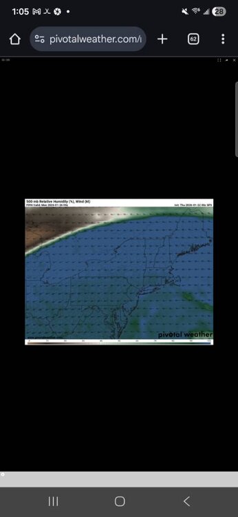
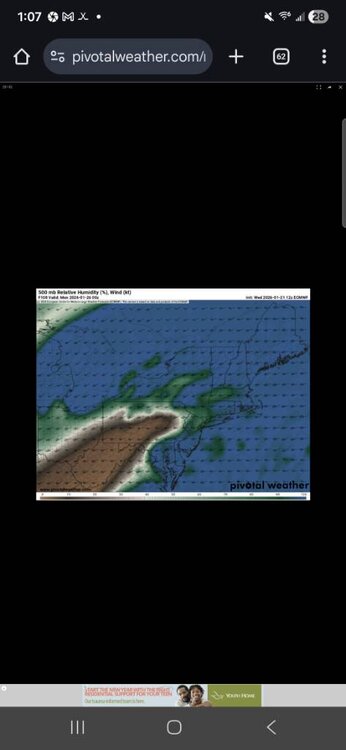
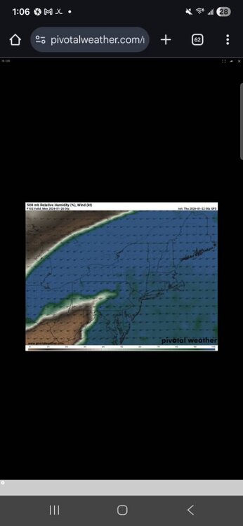
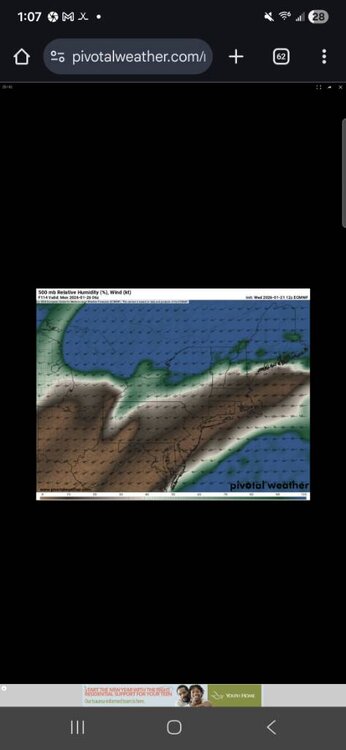
What's the timing with the Baja energy and north vort that is required for a transfer like the GFS Look at the 500mb rh% between GFS and euro at 12z For 00z, 06z Monday Time ordered, GFS first Sent from my SM-S731U using Tapatalk -

Central PA Winter 25/26 Discussion and Obs
Jns2183 replied to MAG5035's topic in Upstate New York/Pennsylvania
The triple phaser might as be weinies version of the ring with how much it's siren song always leads us to think with the wrong body part. I got the knickerbocker in late January 1922 968mb The Great Appalachian storm late November 1950 970mb Great Midwestern blizzard of January 1978 955mb Superstorm March 1993 960mb Halloween Noreaster 2011 971mb That's all I can think of that was legit triple phasers. Logically we really should banish that word until 2030 if not 2035. Alot of people forget about the Halloween one thinking we are so do Sent from my SM-S731U using Tapatalk -

Central PA Winter 25/26 Discussion and Obs
Jns2183 replied to MAG5035's topic in Upstate New York/Pennsylvania


