
BretWx
-
Posts
1,046 -
Joined
-
Last visited
Content Type
Profiles
Blogs
Forums
American Weather
Media Demo
Store
Gallery
Posts posted by BretWx
-
-
1 minute ago, wncsnow said:
Yes but the way these models have been spitting out ridiculous amounts for days on end with ensemble means agreeing to a ridiculous extent.. it is disappointing if we get a typical storm instead of a blockbuster..
Oh, agreed, but I'd still take it. I'm not really going ALL IN until tomorrow around 2PM... lol
-
1 minute ago, wncsnow said:
This is starting to look like your typical 4-6 or 6-8 inch storm with some sleet and ice on top. Nothing once in a generational.. Could be wrong but that seems to be the trend today
I'd gladly take that and run... It's December 6th!
-
Nice to see the CMC come around.... finally.
-
GFS looks good.
-
It's barely even 10AM, and we're talking about NAM at 60hrs.... enough of the cliff-diving please.
-
 1
1
-
 2
2
-
-
Well, that's the first time I've felt like that since this thing started. Onward and UPWARD.
-
12z NAM already trying to throw moisture our way at hr 30....
-
3 minutes ago, BlueRidgeFolklore said:
Generally with this setup, the French Broad River Valley only gets dry slotted around N AVL heading into Madison County. In Transylvania County heading into NW Henderson County, those people usually get hammered.
I feel pretty lucky to live on the east side of Stoney Mountain in Henderson (near Hendersonville). From what I know, it's about 2800 feet up, I'm about 3/4ths the way up.
-
52 minutes ago, Orangeburgwx said:
Heh, I just vented to the NWS CAE office in a private messege on Facebook for not acknowledging the threat as it stands.
Yikes....
-
Hope I didn't jinx anything by taking a personal day tomorrow
")
-
 1
1
-
-
Just now, HurricaneTracker said:
Some stats from 00Z Euro for KAVL:
Probability of 12” of snow = 100%
Probability of 24” of snow = 44%
Whoa!
Sweet Jesus...
-
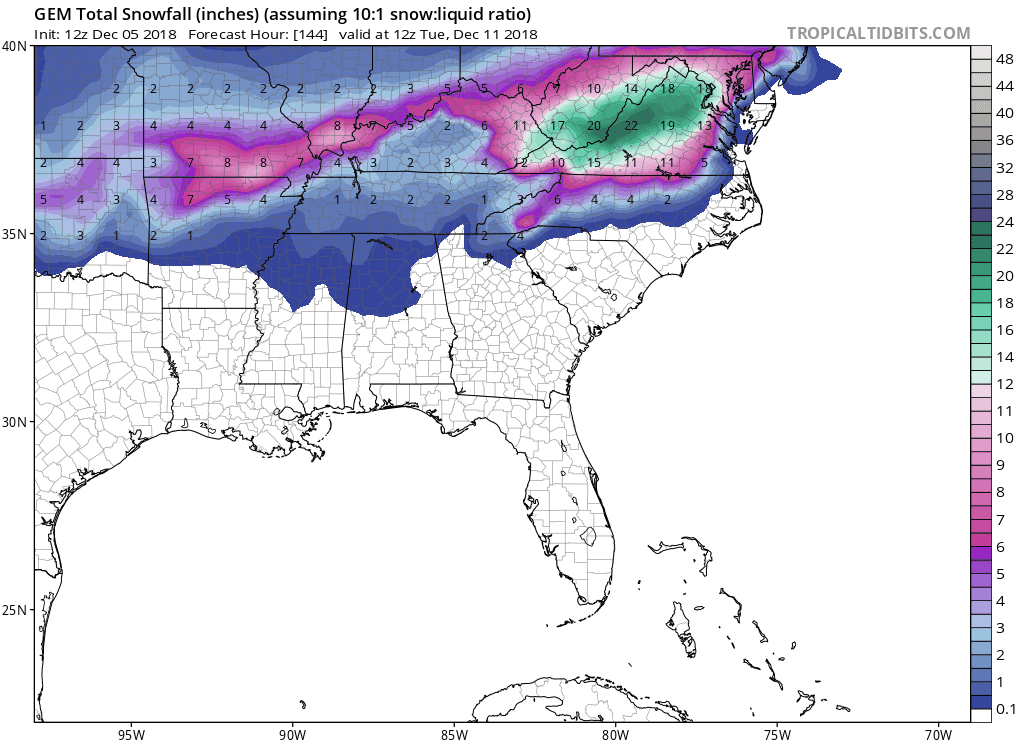
Big jump down on the CMC finally. Editing to say the FV3 looks.... spectacular. 48+ hours of snowfall.
-
1
-
-
6z GFS still a widespread 10-20 for most.
Shows snow from hr 60-126
-
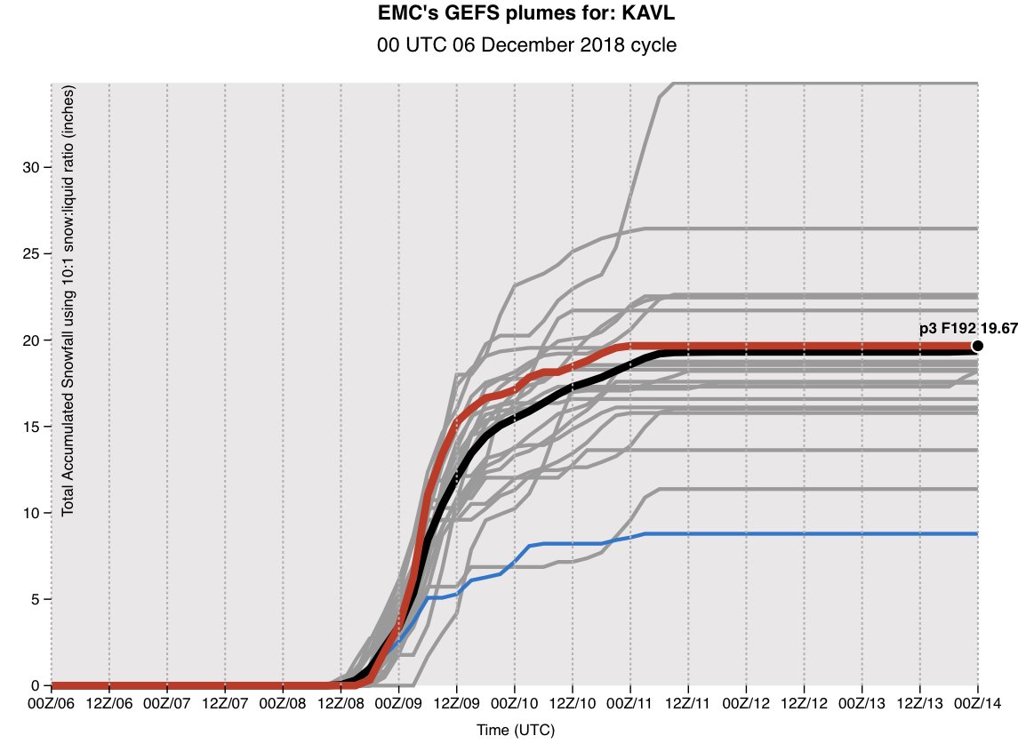
Mean up once again for KAVL...

-
1 hour ago, HurricaneTracker said:
Don’t need to be skeptical. It’s all there. All the cards are on the table. If anything, we may get constructive interference from the northern stream wave (ala 18Z FV3). Everything looks good to me for the moment. It’s OK to geek out on this one - you may never see anything on the magnitude and scale like this again!
Phew. Tomorrow and Friday are going to be a RIDE. Gotta sleep now to prepare.
-
1
-
-
13 minutes ago, ncjoaquin said:
The GEFS mean is 18.45 !!! The GFS deterministic is the bottom. Let me add the mean was 2.27 precip so HT knows I read what he said.
I’m torn between believing watching history unfold (weenie, I know) and still being extremely skeptical. Cheers!
-
@HurricaneTracker thank you for that. Just read most of it out loud to my family, ha! I know a lot can change, but I’m getting close to being all on board.
-
2
-
-
Just now, wncsnow said:
Yes doesn't seem right...
GSP wouldn’t put that map out until at least 6-8 was on the ground already.
-
1 minute ago, wncsnow said:
VERY bullish for them. Especially for southern areas
Have a feeling this is an old image...
-
3
-
-
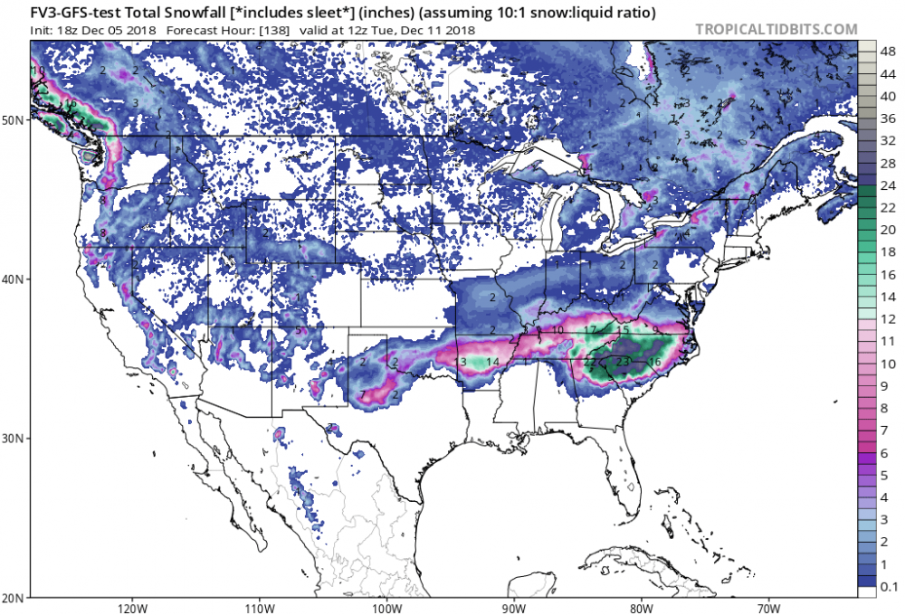
Holy hell @ the 18z FV3 snowing through hr 138...
-
The FV3 skipping frames is driving me insane.
-
WLOS Jason said the word “historic” - get ready
-
3 minutes ago, BlueRidgeFolklore said:
First, 'First Call' map I've seen.

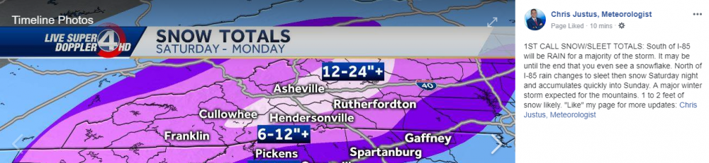
Wild to watch this play out.
-


2018/2019 Mountains and Foothills Fall/Winter Thread
in Southeastern States
Posted
Mean for KAVL jumped from 16.58 to 20.01: http://www.emc.ncep.noaa.gov/gc_wmb/tdorian/gefs/EMCGEFSplumes.html