

HurricaneTracker
-
Posts
727 -
Joined
-
Last visited
1 Follower
.thumb.jpg.10519f3e44bb0a54bf5da5e63a0e8b03.jpg)
About HurricaneTracker

-
Pre-Christmas (Dec 21-23rd) Winter Storm
HurricaneTracker replied to Chicago Storm's topic in Lakes/Ohio Valley
Same here. My parents live in Aurora and my in-laws live in Princeton, IL in central Bureau County. I am visiting them starting Tuesday. Supposed to be in Aurora early Saturday morning. I may be stuck…somewhere in N IL this week… -
December 8-10, 2018 Winter Storm
HurricaneTracker replied to Orangeburgwx's topic in Southeastern States
Don’t look at the 00Z NAM then. Wicked warm nose at 700mb crosses the entire state from west to east. Dang. -
December 8-10, 2018 Winter Storm
HurricaneTracker replied to Orangeburgwx's topic in Southeastern States
18Z NAM....who ordered up an ice storm?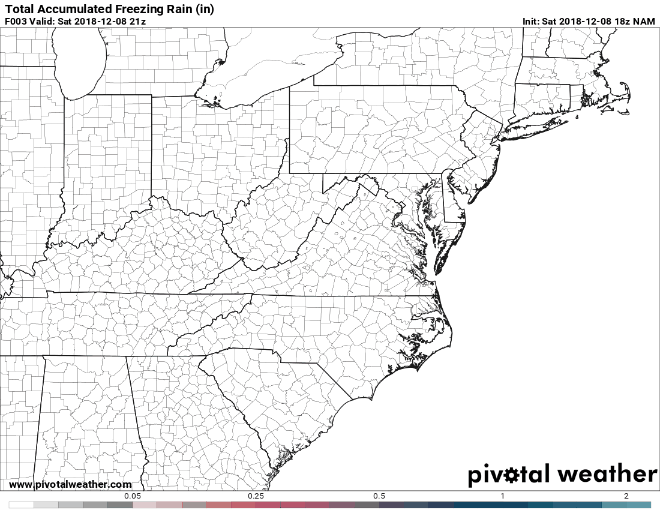
-
December 8-10, 2018 Winter Storm
HurricaneTracker replied to Orangeburgwx's topic in Southeastern States
I’m reducing snowfall totals based on an analysis of all new data. It seems highly likely there will be a layer of warm air aloft that makes it to us overnight. So, while surface temperatures will be in the mid 20s, it will be above freezing at 10,000 feet. So... Asheville: 4-8" of snow and 1-2" of sleet, no ice Hendersonville: 3-7" of snow and 2-4" of sleet, some minor glazing possible Now, if the warm nose fails to materialize (possible, but seems like it will), then the forecast is unchanged from yesterday: AVL: 10-15" HEND: 15-20" So you see what a huge deal this layer of warm air is aloft. I will make another update/revision this evening. -
December 8-10, 2018 Winter Storm
HurricaneTracker replied to Orangeburgwx's topic in Southeastern States
Warm nose really entered the equation for just about everyone along and south of I-40 in NC. Even mountain snowfall numbers get slashed due to mixing. -
December 8-10, 2018 Winter Storm
HurricaneTracker replied to Orangeburgwx's topic in Southeastern States
Looking super promising at the moment. 12Z NAM soundings are surprisingly supportive of all snow (no mixing at all during the event). So then snowfall will be determined by ratios and compaction. -
December 8-10, 2018 Winter Storm
HurricaneTracker replied to Orangeburgwx's topic in Southeastern States
Frankly looks very close to current operational GFS. -
December 8-10, 2018 Winter Storm
HurricaneTracker replied to Orangeburgwx's topic in Southeastern States
A big point for discussion here is that much of this water falls between 12Z Saturday and 12Z Sunday. Some places will see 2 inches of liquid in just 24 hours. Some of that will fall as ice/snow. Yowza. -
Is that even possible!?!? Went shopping in Asheville tonight. Absolutely nobody knew it was gonna snow. One gal said if it did we would get a dusting. Oh my oh my. NWS has some explaining to do...
-
Couldn't agree more. We saw this all last winter too. For whatever reasons, GFS does seem to be the last one to the party with these wave interactions in the winter.


