
BretWx
-
Posts
1,046 -
Joined
-
Last visited
Content Type
Profiles
Blogs
Forums
American Weather
Media Demo
Store
Gallery
Posts posted by BretWx
-
-
lol @ GFS showing 9 inches here through hr 36...
-
RGEM looks like it's going to crush.
-
Holy f*** through hour 60.

-
 1
1
-
-
Just now, HurricaneTracker said:
NAM is HUGE!!!! ALL SNOW SOUNDINGS for just about the entire event. Closing in on 20-25" across Henderson, Transylvania, Buncombe, and McDowell counties.
Yeah, I'm pretty speechless. This is starting to look like the *once mentioned* "once in a generational event"... lol
-
3 minutes ago, BretWheatley said:
NAM coming in colder. Snow tomorrow AM already.
This is going to be a hell of a run.
-
NAM coming in colder. Snow tomorrow AM already.
-
Where's our official list of things to keep an eye on out west throughout the day to determine flop potential?
")
-
16 minutes ago, Tyler Penland said:
Is it just me or is radar already way juicier than it's supposed to be?
Yeah I didn’t really expect to see that fringe precip/verga until tomorrow AM...
-
I wish there was a LOVE reaction for that post @HurricaneTracker - I'm ALL IN now. Passed 4 gas stations on the way into the office, all out of gas. It has begun.
-
2
-
-
Would really love to see the Euro nail this one. Not being selfish, I swear. Hell, even the GFS is about a foot near Hendersonville.
-
2
-
-
Such a good look from everything right now. Someone’s getting 20.
-
And.... we’re back!
-
Just woke up and checked the 00zs... beautiful.
Edit: Also see the GEFS WPF mean is now over 3 inches... Getting better and better!
-
-
2 minutes ago, cold air aloft said:
I know folks have varying opinions of TWC, but Tom Nizzel is still confidently bullish on this event for most of us. Calling for around a foot for most of the mountains.
Yeah, he’s been dropping large totals all evening. It has me confused, ha!
-
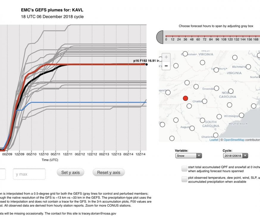
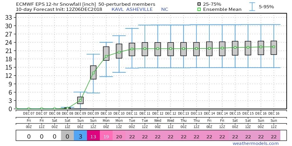
GEFS mean back up to near 17 inches at KAVL, QPF 2.6
-
1
-
-
Just now, BooneWX said:
I just don’t know what to make of the FV3....I mean it’s supposed to be the new GFS in a few months, but I mean...30 inches. I hope so, but dang that’s hard to buy.
This will be... it’s first real test. Either way, a lasting impression.
-
1
-
-
The weather channel just mentioned the blizzard of 1886, referencing Asheville, and even pulled the map up and said “history does repeat itself”.... lol
-
1
-
-
4 minutes ago, HurricaneTracker said:
Good evening everyone. I wanted to take a moment and give y’all an update in light of the disastrous communications issue that is unfolding before our eyes.
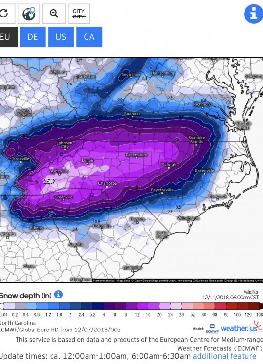
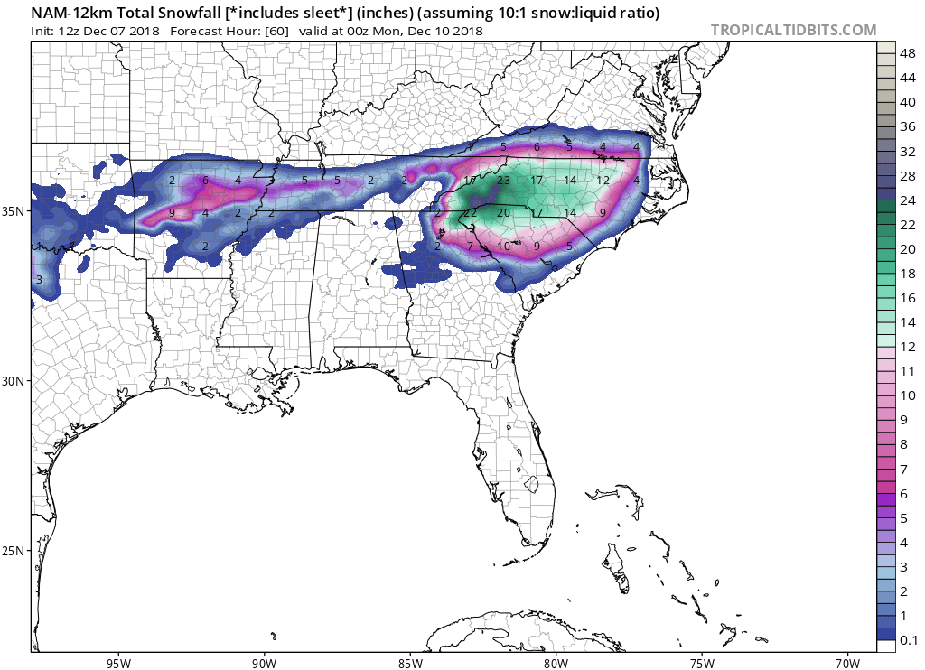
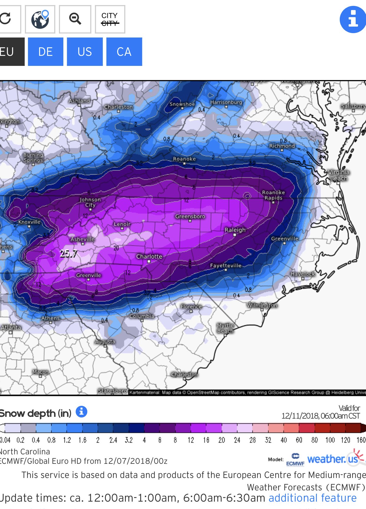
1. Overall things have NOT changed that much since this time yesterday. Euro came in with a swath of 20”+ from KAVL to KTNB and consistent liquid equivalents around 2.50”. Duly noted is that the Euro was NOT mentioned in the afternoon discussion by GSP. It has been absolutely rock solid on this storm system since last Saturday! To boot, we added the CMC model today with a lot of liquid equivalent, too. And now the 18Z FV3 (which we should all be looking at since it IS our future!), comes in with at least 2.00” of liquid (minimum QPF in Bristol, TN but that is expected given the setup).
2. 12Z NAM was a dumpster fire and has since corrected itself at 18Z (more corrections coming too, I suspect). 12Z GFS was a dumpster fire (just ridiculously low QPF) and p-type issues abound. Yet, this is the model of choice today by GSP. Oh but wait there’s more! 18Z GFS self-corrected and came in with more QPF and colder wedging solution. You want to hang your hat on the GFS? Better be ready to make more changes to the snowfall forecast as the GFS shifts.
3. Let’s talk warm nose. Does it exist? YES. Someone in the main thread said NE Georgia was out of the snow. I agree. This is climatology. Even parts of the favored escarpment areas will see sleet for a time being Sunday morning. What is confusing the models is the isothermal layer in the soundings. My eye sees the isothermal layer as a deep layer of snow, since dendrites will be falling into this isothermal layer. ALL MODELS say that even at 850mb temperature of 0.1 deg F this melts the flakes. I just completely and utterly disagree. In all my years of forecasting, deep isothermal layers that hover on the 0 deg isotherm (and are below freezing either side of this layer) tend to run as all snow. Watch for this in the next 24 hours.
4. Do we need to cut down snow amounts? Maybe. But don’t forget we are using a 7:1 ratio anyway to start with (see my post from yesterday). So instead of 2.50” of liquid coming out to 17.5” of cement, maybe we go 2.00” of liquid and 14” of snow. I’m currently most comfortable going with a range of 8-12” for KAVL and the eastern escarpment. Boone will see slightly more sleet because they are actually *too high* in elevation and above the wedge into the warm nose. So instead of 17” there, I think 8-12” also applies to them.
Hang in there folks. Watch the 00Z trends. Can’t ignore the intense dynamics and the fire hose that is our deep tropical moisture connection!
Supposedly I’m out of reactions for the day, but THANK YOU!
-
1
-
 1
1
-
-
FV3 looking great. I know things will change tomorrow. Enjoying the ride!
-
4 minutes ago, McDowell_Weather said:
Idk guys ive definitely lowered expectations for big totals i cant shake feb 2014
Likewise. Of course, a better way to go into these things. Honestly half the fun is the week leading up to it. This has been the fastest in recent memory!
-
1
-
-
18z GFS looks like 10-15 for me down here. However, now expecting 1 inch. Time for a beer. Cheers!
-
1
-
-
6 minutes ago, BlueRidgeFolklore said:
WTH is GSP doing?
This is the most insane map I’ve ever seen... lmfao
-
When the Euro is showing 20-30 inches less than 48 hours out... I listen.
Edit: Sorry, just really annoyed that the triad mentions getting 10 inches and we... well, lol.
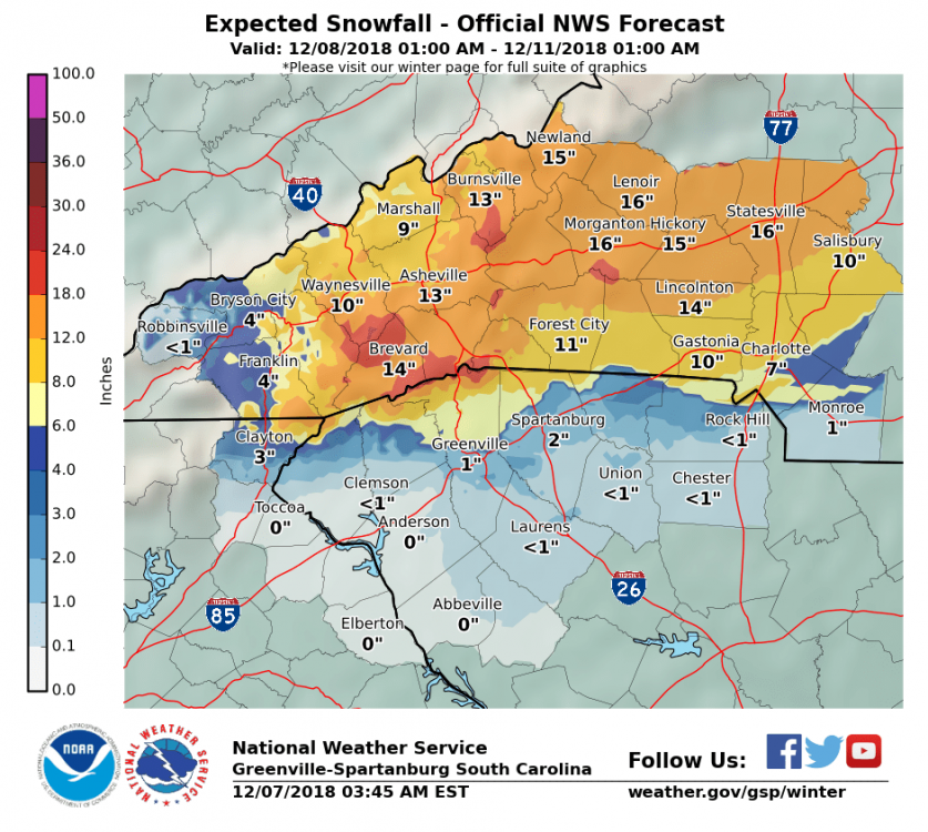
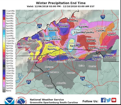
* WHAT...Significant accumulations of snow combined with sleet and
  freezing rain is expected. Total snow accumulations of 4 to 8
  inches combined with ice accumulations of up to one tenth of an
  inch are possible. The greatest snow amounts are likely to be in
  the Triad, where amounts could approach 10 inches.


2018/2019 Mountains and Foothills Fall/Winter Thread
in Southeastern States
Posted
definitely colder.