TJay
-
Posts
796 -
Joined
-
Last visited
Content Type
Profiles
Blogs
Forums
American Weather
Media Demo
Store
Gallery
Everything posted by TJay
-
Upton just issued a sternly worded warning package for the forecast area to numerous to post here. Snowcane II 18Z NAM was left of the BM, perfect for the HV
-
Jay I sent you the instructions. Off to rearrange the garage and put the snow blower by the door.
-
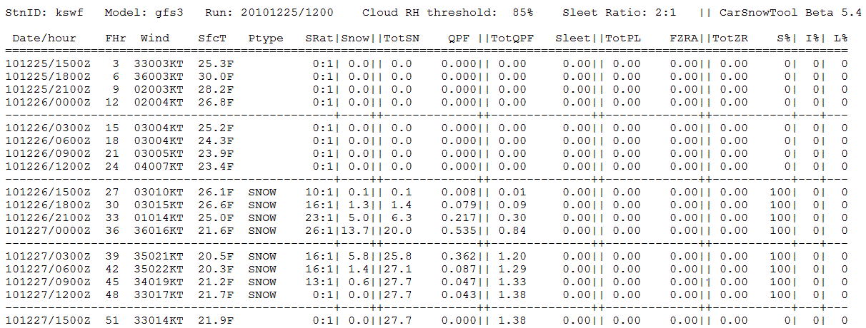
12/25 12Z BUFKIT for KSWF for KPOU
-
Draft BM was nothing like the bottled version (not surprising) Checkout the KSWF bufkit totals I posted. 13.8 inches in 3 hours Jeez this storm has me hooked now.
-
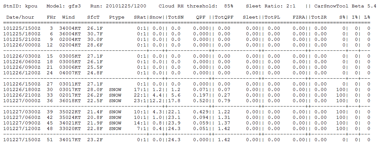
KSWF BUFKIT 0Z GFS
-
It was Belgian White Ale. Wow coors? Thats a shocker given their tasteless, watery mainstream beers I think I'll snek a peek at tonights 12Z runs if I get a chance
-
Merry Christmas Rob and everyone else!! The 18Z GFS is a huge hit for the low and mid valley. I honestly don't know what to make of this soap opera of models fliping away, HPC tossing out 12Z GFS because of data errors but not tossing the 12Z NAM that had the same data ingested and now a dream hit on the 18Z GFS. It is truely stange and I feel the same way I did last Feb when we were tracking the snowcane when the models started showing the fully bombed out super storm doing a loop tour of NYC, CT, HV, NEPA, NJ. I don't know what to make of this. OT : I was in Fridays last night and they had a Blue Moon Draft special. It was served with a slice of orange. the beer was unfiltered, it was fantastic. Anyone have a guess as to what Blue Moon version it might have been?
-
Check out the 18Z NAM, phases and west but not quite west enough for NYC.
-
HPC is disregarding the 12Z GFS solution Said the errors effect GFS, NAM and Euro 12Z runs now we wait again
-
Nice hit on the 12z GFS for the valley rockland then east of the river do very well. Mid western valley does slightly less with a phase just in time to track it west. 12Z NAM does not phase and is farther east. With the GFS standing alone with the hit atm, some drama for the holidays. . Upton's morning disco before the 12Z GFS TRICKY PART OF THE FORECAST FOR SUNDAY NIGHT IS EXACTLY HOW FAR WEST IS THE BACK EDGE OF THE SNOW...FOR NOW HAVE AT LEAST CHANCE POPS OVER THE ENTIRE CWA (LIKELY FAR EAST)...BUT EVEN THE GFS BARELY HAS MEASURABLE QPF INTO ORANGE COUNTY. SNOW SHOULD TAPER OFF TO SHSN/FLURRIES DURING THE DAY ON MONDAY. BASED ON THE MODEL BLEND USED...IT APPEARS THAT THERE IS A HIGH END CHANCE TO A LIKELIHOOD THAT THERE WILL BE MEASURABLE SNOW FALL EAST OF THE HUDSON RIVER...WITH THE BEST CHANCE OVER CENTRAL/EASTERN CT AND LONG ISLAND...WITH THE BEST CHANCE OF WARNING LEVEL SNOWS OVER EASTERN CT/LONG ISLAND - NOT SAYING WARNING LEVEL SNOWS ARE NOT POSSIBLE FURTHER WEST...JUST THAT THE BEST CHANCE FOR THEM IS OVER EASTERN PORTIONS OF THE CWA. IN ORDER TO GET WARNING LEVEL SNOWS WEST OF THE HUDSON...IT WOULD TAKE A SHIFT IN TRACK ABOUT 100 MILES TO THE WEST...THIS IN UNLIKELY BUT STILL WITHIN THE REALM OF POSSIBILITIES. IT ALSO POSSIBLE (AND MORE LIKELY THAN A 100 MILE WESTWARD SHIFT IN TRACK) THAT THE STORM COULD TRACK FURTHER EAST THAN FORECAST...BRINGING AT MOST ADVISORY SNOWS TO EASTERN AREAS...IF ANY PRECIPITATION AT ALL.
-
Yes it does but didnt wnt to say anything.
-
Radders is the euro showing a warm up next week?\
-
:blahblah:
-
I'm thinking 12Z with all data available to the models should bring solutions that agree with each other. Until then, I'm turning in. Thanks again.
-
Thanks for the PBP Radders
-
how much precip for the area Radders? I am guessing .50 ?
-
its still down south hasn't come up yet
-
I liitle south of the GFS at 78 seems the speed matchs well
-
might set the table for a neg tilt
-
How is the placement is relation to the sw of the 0z GFS?
-
I am interested in seeing if the sw speed picks up from its eariler runs
-
let it roll
-
Cool I'll most likely be here
-
I was a charter sub in accuweather pro but I canceled it years ago, the euro was pretty bad on their site back then. In hind site I should have keep it because my renewal rate was $99 a year even when they rasied it up to $200+ .
-
On Vacation for the holidays! So I am GOOD until I get a call How are you? Hey if you, Radders, Rob and the rest of the guys are going to do model disco in here I'm in