

moneypitmike
-
Posts
29,869 -
Joined
-
Last visited
Content Type
Profiles
Blogs
Forums
American Weather
Media Demo
Store
Gallery
Posts posted by moneypitmike
-
-
9 minutes ago, ORH_wxman said:
Awaiting the rapid development later
I’m hoping we’re not too far NW. i think we’ll be okay….but further east is going to score.
-
Family in Marblehead and Charlestown are impatiently waiting for the cold front to come through. I told them by noon. I hope I’m right.
-
6 minutes ago, CoastalWx said:
It will also depend on coastal front timing. That depiction snows snow at like 34F which won’t do anything.
My brother in law said it’s been snowing in Marblehead 1/2 from the ocean. Nothing to show for it there, but he said it is beginning to accumulate as you head toward Salem
-
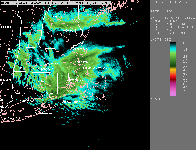
radar is blowing up nicely in RI and SE MA. Hopefully not too far east as it treks north.
-
13 minutes ago, backedgeapproaching said:
ALY had a little write up overnight and why the relative porking with the intital WAA push. Only 3-4" here. Local guy at 1900' reported 4.5" and Stratton 5" I believe.
Snow is continuing across eastern New York and western New
England, however expectations of spatial coverage has not
exactly met reality due to the evolution of the coastal system
now currently located east of the Delmarva. According to SPC
Hourly Mesoanalysis, the parent shortwave trough has pulled
ahead and east of the coastal low, forcing its deepening to come
to a staggering halt and stretching energy further east.
Because of this, the precipitation shield has shifted to the
east with very minimal northward progression. A secondary low
pressure core has formed across western Pennsylvania in
association with an upper trough, acting as another source to
drain energy from the aforementioned coastal low and
simultaneously push it further east in tandem with the pull of
the upper shortwave pulse.
"staggering halt' lol
-
22 minutes ago, moneypitmike said:
And now we lull.
sn- with the radar filling it......so hopefully that will translate to a return to good rates.
Short-lived lull.
Back into steady, but not the fatties of the earlier band. Still getting the job done though.
-
Wagons north on the RAP. Meh for SNE.

-
-
2 minutes ago, WxWatcher007 said:
Euro is pretty wild. Gotta imagine that’s overdone.
dets?
-
27 minutes ago, PowderBeard said:
That is the "Hold my beer" or "Watch this!" of weather nerd quotes.
And now we lull.
sn- with the radar filling it......so hopefully that will translate to a return to good rates.
-
Any sign of the geese?
-
 1
1
-
-
1 minute ago, MRVexpat said:
0.0" in Cambridgeport. Starting to rip fatties at times and coating up mulch beds etc. We'll see what today brings.
It will get better.
-
1
-
-
1 minute ago, tunafish said:
Portland, ME
Date - Time: New | Liquid | Depth | T/D | obs
-------------------------------------------
1/6 - 1300: Trace | Trace | 0" | 28/15 | ovc
- 1900: 0 | 0 | 0 | 27/18 | ovc (@ 2000 -SN)
- 2400: T | T | T | 23/16 | -SN
1/7 - 0700: 3.7" | 0.50" | 20/18 | -SN
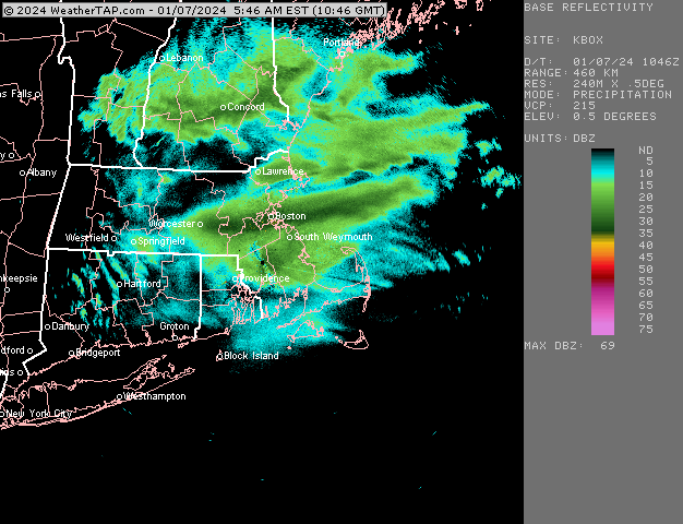
Gyx radar is looking great for pwm and west. Hopefully it’ll inch north so Pit2 and other areas to the NE can cash in.
-
Just fantastic here......who knows.....we might not lull.
(famous last words).
-
1
-
-
2 minutes ago, Henry's Weather said:
How do you guys compress your photos? Can’t get mine below 1.95 MB
are you uploading from your i phone? It's kind of tricky.....
add the picture.......you'll see something in the lower right that says 'actual size'. tap/scroll down and you can select other sizes. I usually do medium.
-
 2
2
-
-
I wish my snowblower would start.


-
2
-
 1
1
-
-
Just measured 7.5"
Not sure how much of that net 1.5" was due to new vs. paste compaction.
Steady fatties. 27*
-
14 minutes ago, ORH_wxman said:
Band just stationary now back this way
It's a beautiful thing--let it ride.
28*
-
2 minutes ago, moneypitmike said:
Front might be slipping through. Down to 31*
Confirmed.....now 30*. Powder it up.
-
1
-
-
Front might be slipping through. Down to 31*
-
4 minutes ago, ORH_wxman said:
Yeah this band has slowed almost to a halt. That would be awesome to sit under this for a couple hours
If this is what our lull will consist of, we'll be in good shape.
-
Life is good under this Route 9 band.
Ripping fatties.

-
1
-
-
10 minutes ago, ORH_wxman said:
It’s possible I have a bit more. Just looked out window pretty quickly. I don’t think I have 6” though. You may have also gotten slightly better ratios.
I did 3 quick measurements and that's waht I came up with . Nice to be in this steady ORH-BOS band now. It looks like it's let up otherwsie in the area until the CCB.
-
7 minutes ago, ORH_wxman said:
Cranking here right now….we didn’t get the really heavy stuff like just north of here did for several hours. Looks like about 3-4” eyeballing
I'm surprised you don't have more.....I measured 6".
Big fattie's at the moment....like a Pickles class.

January 6-7, 2024 Winter Storm Obs Thread
in New England
Posted
8,5