
snowlover2
-
Posts
2,721 -
Joined
-
Last visited
Content Type
Profiles
Blogs
Forums
American Weather
Media Demo
Store
Gallery
Posts posted by snowlover2
-
-
-
8 minutes ago, buckeye said:
Rgem is a nice hit now ....lol
Impressive deform band.
-
Looks like deform band starts cranking up sooner on the 3k NAM.
-
0z NAM has a low traveling through TN and rain up to I-70. Just don't buy the rain/snow line that far north with that low position.
-
Sitting at 6.5" so far. Easily the best storm in years.
-
 1
1
-
-
Got 4" here with steady light snow.
-
26 minutes ago, HighTechEE said:
Made it to 2" and poof, dry slotted for the rest of the afternoon, unless it fills back in somehow.
It's filling back in.
-
6 minutes ago, Snowless in Carrollton said:
Winter Storm Warning for my area. 4-7 inches.
The near 4 year warning drought for Dayton is over!!!
-
3
-
-
20 minutes ago, hlcater said:
Euro just came in and added significantly more QPF on the northern side of the system. Would probably give CR 4-5" as ratios would probably be ever so slightly higher than 10:1. Though there isn't a lot of forcing out here on soundings so flake size is probably gonna suck like Hoosier was alluding to.
Snow continues in S IN/S OH after this so the first shade of green makes it into SW OH and the second shade of green into S IN.
-
11 minutes ago, dilly84 said:
Guess I'm the only one not excited. Hard to get excited about 1-3" of snow. Unless you live in Southwest Ohio this looks to be a dud. Hope not, but that's the way it looks to me as of now. 0z nam gives a 2" across most of central Ohio.
OP NAM has been killing the snow much faster than any of the other models. 0z 3K NAM has 4-5" for central OH and up to 6" my way. 0z RGEM which only goes to 48 hours is very 3k like. Seems a good bet OP NAM is shutting off snows to quick.
-
3k NAM doesn't kill off the snow anywhere near as fast as the OP. Results in better totals farther east.
-
18 minutes ago, Snowless in Carrollton said:
Why didn't they issue a Winter Weather Advisory ?
Its going to be Saturday early morning when it starts around here so I can understand the holding off. They will likely issue that at the 4am update tonight or if the 0z runs continue what appears to be a trend today increasing amounts they might go right to a warning without the watch. It's happened many times here in the past.
-
ILN issued WSWatch for the lower criteria counties around and including Cincy.
-
-
5 minutes ago, Malacka11 said:
That's what I've been thinking too, but iirc someone already referenced the 12z FV3 as being the opposite of the normal GFS. Oh well
")
12z FV3 just starting to roll now.
-
Just now, Malacka11 said:
Anyone have a access to para-GFS snowfall maps?
Don’t think 12z is out yet.
-
5 minutes ago, vespasian70 said:
I also noticed the time stamp was 'off'. I didn't check last night, is this a different solution than the last run?
Generally the same as the 18z run but a touch north with the higher totals in Ohio.
-
1
-
-
1 hour ago, buckeye said:
6zGfs continues to slip away....
Meanwhile the euro trends better.
Hopefully today we get some concensus
 but usually decent storms come together on the major models when you're inside 4 days...so this late game divergence doesn't bode well for a significant storm.... jmho
I see FV3 is loading again although its still on 0z but it's amped up too along with NAM/Euro.

-
Hour 84 and snowfall to that point.


-
1
-
-
0z NAM continues to look amped.
-
So saw this 18z FV3 QPF map posted. It seems to be in the NAM camp with a large 1.00" QPF area meaning likely a large 10"+ snow area.

-
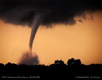
7 minutes ago, Hoosier said:
Possible tornado in eastern Ohio today.
Already classified as EF1.
-
8 minutes ago, Thundersnow12 said:
18z NAM came in way hot/amplified with the southern plains wave compared to other guidance valid at 6z Saturday. 850mb low stronger/further north as well and a stronger LLJ is able to throw that moisture/precip much further north.
Probably a mirage.
Lost count how many times in the past that was said only for the NAM to verify.
-
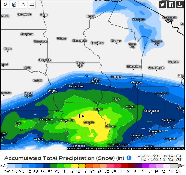
0z Euro didn't weaken the snow as fast as it moved east leading to slightly higher totals for IN/OH. 4-8" for S IL/MO, 3-4" east to Indy and 1-2" east through Ohio.


Let's Talk Winter!!
in Lakes/Ohio Valley
Posted
Kuchera