
snowlover2
-
Posts
2,721 -
Joined
-
Last visited
Content Type
Profiles
Blogs
Forums
American Weather
Media Demo
Store
Gallery
Posts posted by snowlover2
-
-
2 minutes ago, Malacka11 said:
Euro looks cute for the D-7 threat
0z runs seem to put everything on the table. GFS was a suppressed nothing. GGEM was basically an apps runner and Euro was a cutter.
-
18z GFS is weaker and suppressed basically missing everyone.
-
 3
3
-
-
1 hour ago, buckeye said:
It's really hard to imagine any storm not cutting well nw of us under this current pattern. Even the temporary cold shots will probably become muted as long range turns into short range. Not being a downer....we are just in an absolutely hostile pattern for winter storms, at least through the first 10 days of January and probably well beyond.
Just seems fishy especially on the Euro to go from suppressed/non existant to that much of a cutter in 1 run and its members appear to confirm this. Majority are farther south and some much farther south giving snow to northern parts of MS/AL/GA/Carolinas.
-
30 minutes ago, snowlover2 said:
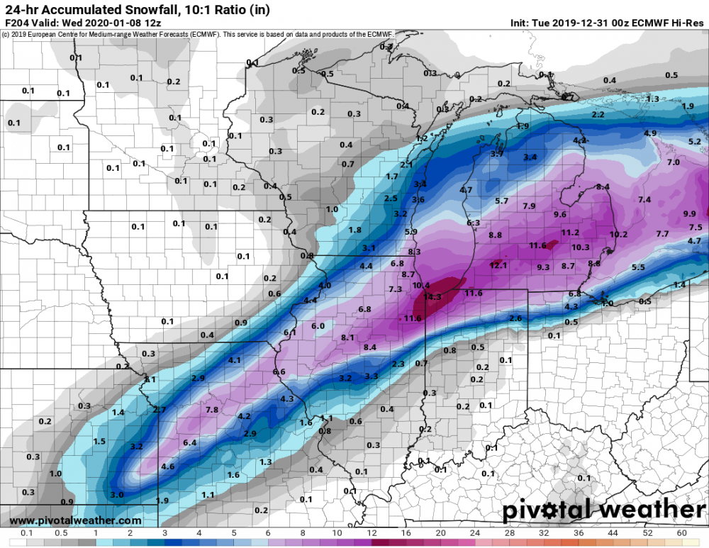
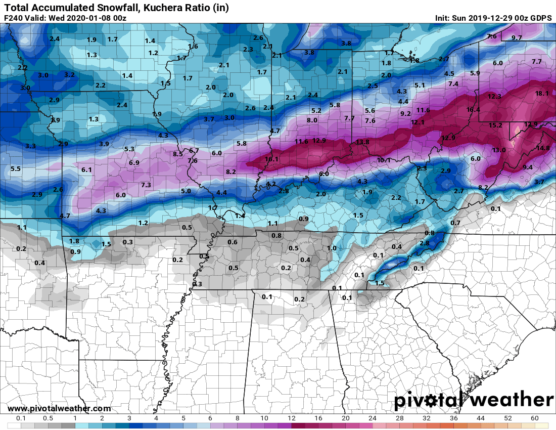
12z GFS has the Jan 7th threat back and farther north dropping 5"+ from NE IA to Central MI. 12z GGEM farther south with 3"+ across S IN/S OH.
12z Euro looking like GFS.
-
12z GFS has the Jan 7th threat back and farther north dropping 5"+ from NE IA to Central MI. 12z GGEM farther south with 3"+ across S IN/S OH.
-
7 minutes ago, dayton1996 said:
Snowlover2
Was that 2014 microburst the same one that gave me a ton of hail damage to my roof? Anyways, back to Winter....
I remember enjoying the Winter of 2013/2014. Starting in December, we have multiple snow storms throughout. Some forecast, a couple of misses, and a couple of surprises.
No this was an isolated microburst across the eastern half of Montgomery County from a cell that traveled south to north causing significant wind damage. It was June 23 to be exact. I'm assuming you are talking about the supercell that dropped 3" hail around Centerville/Miamisburg area and into SW Greene County. Thinking that was possibly in 2011 or 2012.
-
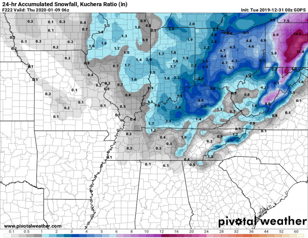
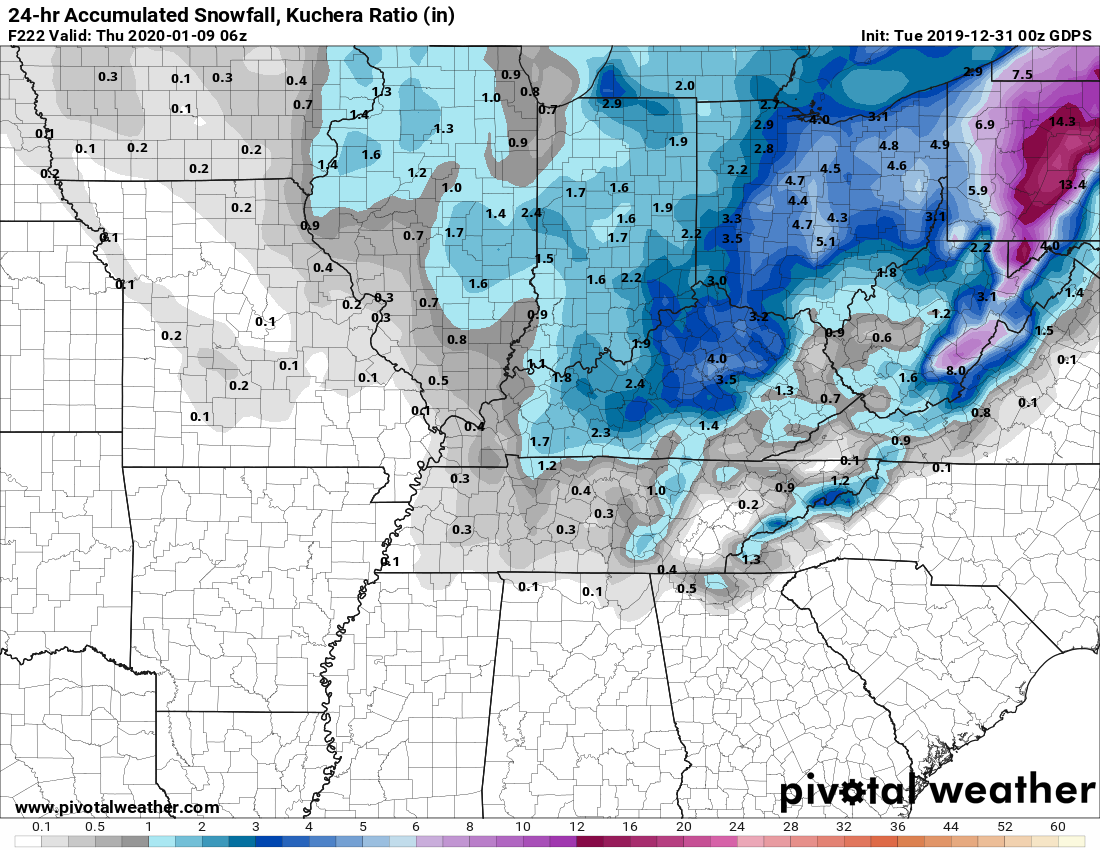
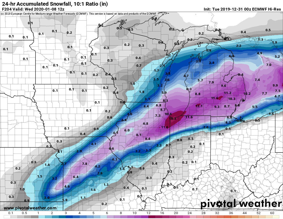
0z GFS had nothing for the January 7th threat but 0z GGEM was back on board with 3-6"+ for a good chunk of IN/OH.
-
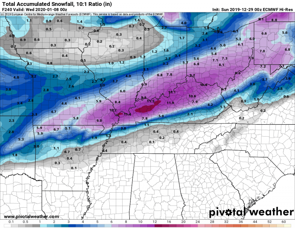
0z GGEM and Euro both look really interesting for I-70 down to and south of the Ohio River for January 7. GGEM is Kuchera but Euro is not since it's not available on pivotal though i'd imagine it looks similar if not more than GGEM. GFS has a storm but it gets shoved to the gulf coast due to a likely overdone push of cold air.

-
 1
1
-
1
-
-
23 minutes ago, pondo1000 said:
Tell you what, we are scoring big time in the dense fog advisory category this fine December!

Was wondering how long it would take them to issue that. Very foggy here in Dayton.
-
Things off the top of my head...
2012 Derecho
2014 June microburst causing substantial damage in my neighborhood
2019 Mid January snowstorm breaking a near 4 year winter storm warning drought.
Spring brought heavy rains and flooding.
Unexpected Memorial Day tornado outbreak. I say that because it was supposed to be more of an IL/IN event. EF4 was 1/2 mile north of me.
Minor snowfall in November at having 90's to end October.
-
1
-
-
Merry Christmas all!
-
2
-
-
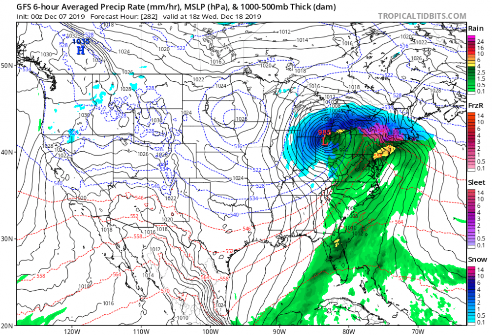
Last thing I expected to see out of the Euro.
-
1
-
-
Today is the 15 year anniversary of the 2004 pre Christmas winter storm. Won't ever forget those 2 days.
-
1
-
-
20 minutes ago, chuckster2012 said:
Eye candy? For whom?
Yeah not us but GFS fantasy land hasn't really showed anything for some time until now so decided to share it for the heck of it.
-
0z GFS providing some fantasy eye candy.

-
1
-
 1
1
-
-
18z GFS tries to get interesting with the storm next weekend for the southern sub and then lake effect cranks up for a day or 2 as the storm moves east.
-
1
-
-
12 minutes ago, HillsdaleMIWeather said:
0Z GFS hinting at a system towards the end of the month
Not everyday you see a storm transfer from NW IL to just SE of Cincy.
-
1
-
-
6 hours ago, Jackstraw said:
Also it's the annual battle of the AFD's. KIND has me at 4-6 with FRZA mixing in, and curiously only a WWA for technically warning criteria snow. IWX, 2 miles to my north, has me at 2-4 with no mixing issues and curiously no WWA with technically advisory criteria amounts. Baffled a bit, they both betting high? Let the winter games begin lol.
It could be because this is happening with 2 waves over a 24 hour period. If they are like ILN who's criteria(in part) is 8" in 24 hours, then it won't meet the criteria.
-
29 minutes ago, Stebo said:
Yep, just like when Snowlover2 posts, I know most of the subforum is about to get screwed.
Come on now. That's not entirely true.
-
6z NAM joins the other models farther south.
-
1
-
-
0z GFS with another teaser.

-
1
-
-
24 minutes ago, Natester said:
Not in the subforum but this is one of two tornado reports in central Iowa from today where temps are only at 40-42F.
PRELIMINARY LOCAL STORM REPORT
NATIONAL WEATHER SERVICE DES MOINES IA
433 PM CST SAT NOV 30 2019

.TIME...   ...EVENT...      ...CITY LOCATION...     ...LAT.LON

.DATE...   ....MAG....      ..COUNTY LOCATION..ST.. ...SOURCE.

            ..REMARKS..

0405 PM     TORNADO          4 NE GUTHRIE CENTER     41.73N 94.45W
11/30/2019                   GUTHRIE            IA   PUBLIC

            TWO REPORTS OF BRIEF SPIN-UP ROPE TORNADO
            ROUGHLY 4 MILES NORTHEAST OF GUTHRIE CITY.
            DID NOT LAST LONG.
Actually it is.
-
0z Euro

-
2
-
-
0z GGEM
-
1
-


Winter 2019-20 Medium/Long Range Discussion
in Lakes/Ohio Valley
Posted
Looked like 0z GFS was trying for a snowier backside for the Saturday storm like the Euro had.