
snowlover2
-
Posts
2,729 -
Joined
-
Last visited
Content Type
Profiles
Blogs
Forums
American Weather
Media Demo
Store
Gallery
Posts posted by snowlover2
-
-
-
PDS tornado warning SW of St. Louis.
-
2 minutes ago, snowlover2 said:
Peoria under a tornado warning. There was a confirmed SW of there.
Confirmed now.
QuoteSevere Weather Statement National Weather Service Lincoln IL 251 PM CDT Wed Mar 19 2025 ILC057-143-179-203-192015- /O.CON.KILX.TO.W.0017.000000T0000Z-250319T2015Z/ Woodford-Fulton-Tazewell-Peoria- 251 PM CDT Wed Mar 19 2025 ...A TORNADO WARNING REMAINS IN EFFECT UNTIL 315 PM CDT FOR WEST CENTRAL WOODFORD...EAST CENTRAL FULTON...NORTHERN TAZEWELL AND CENTRAL PEORIA COUNTIES... At 250 PM CDT, a confirmed tornado was located over Glasford, or 8 miles west of Pekin, moving northeast at 65 mph. HAZARD...Damaging tornado and quarter size hail. SOURCE...Weather spotters confirmed tornado. IMPACT...Flying debris will be dangerous to those caught without shelter. Mobile homes will be damaged or destroyed. Damage to roofs, windows, and vehicles will occur. Tree damage is likely. This tornado will be near... Peoria, Bellevue, Mapleton, Marquette Heights, Bartonville, Peoria International Airport, Creve Coeur, and Pekin around 255 PM CDT. West Peoria and East Peoria around 300 PM CDT. Germantown Hills around 305 PM CDT. Spring Bay and Washington around 310 PM CDT. Other locations impacted by this tornadic thunderstorm include Norwood, Mossville, Kickapoo, North Pekin, Banner, Smithville, Alta, Peoria Heights, Powerton, and Bay View Gardens. This includes the following highways... Interstate 155 between mile markers 28 and 31. Interstate 474 between mile markers 0 and 14. Interstate 74 between mile markers 82 and 109. PRECAUTIONARY/PREPAREDNESS ACTIONS... To repeat, a tornado is on the ground. TAKE COVER NOW! Move to a basement or an interior room on the lowest floor of a sturdy building. Avoid windows. If you are outdoors, in a mobile home, or in a vehicle, move to the closest substantial shelter and protect yourself from flying debris. && LAT...LON 4044 8982 4053 8998 4092 8964 4082 8945 4074 8933 4061 8933 TIME...MOT...LOC 1950Z 225DEG 58KT 4055 8979 TORNADO...OBSERVED MAX HAIL SIZE...1.00 IN -
Peoria under a tornado warning. There was a confirmed SW of there.
-
 1
1
-
-
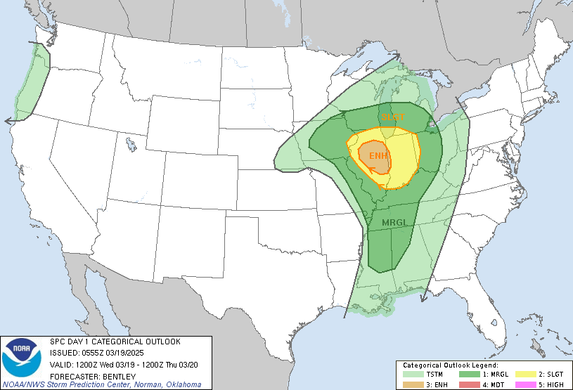
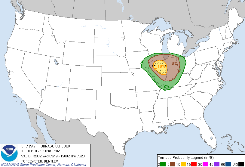
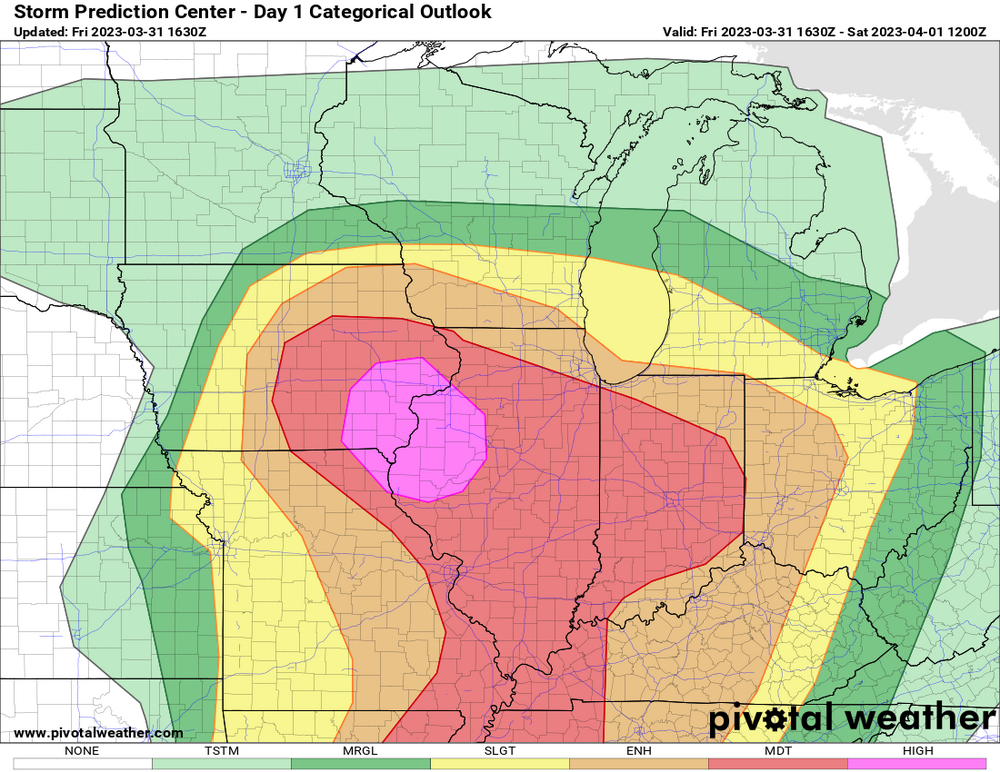
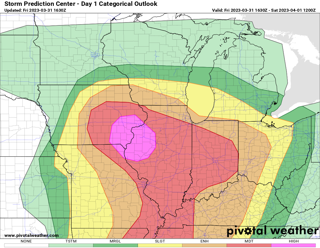
Small enhanced added for tornadoes and slight risk expanded.
QuoteDay 1 Convective Outlook NWS Storm Prediction Center Norman OK 1255 AM CDT Wed Mar 19 2025 Valid 191200Z - 201200Z ...THERE IS AN ENHANCED RISK OF SEVERE THUNDERSTORMS ACROSS CENTRAL ILLINOIS INTO FAR WESTERN INDIANA... ...SUMMARY... Scattered severe thunderstorms are possible on Wednesday across parts of central Illinois to western Indiana from mid-afternoon to early evening. Several tornadoes, large hail, and damaging wind gusts will be possible. ...Synopsis... A strong mid-level low will move from northeast Kansas this morning to Lower Michigan by 12Z Thursday. A strong mid-level jet streak along the southeastern periphery of this area of low pressure will translate from northeast Oklahoma to central Illinois. Meanwhile a surface low within the left exit region of this upper-level jet will move from northeast Kansas to north-central Illinois. ...Central Illinois into north-central Illinois and western Indiana... A rapidly changing environment is forecast across Illinois today. Extensive cloudcover is expected across the state for much of the day as low-level moisture streams north within a narrow corridor ahead of the cold front. However, by mid to late afternoon, some clearing is expected which may allow for some brief heating and destabilization across central Illinois. In fact, the HRRR shows what appears to be a dryline by mid afternoon. Mid-level temperatures will be very cold (-22C at 500mb and -4C at 700mb) which will allow for rapid destabilization with only slight heating. Once destabilization begins ahead of the cold front/dry line, expect thunderstorm development. The wind profile across central and northern Illinois will support supercells, but the intensity of these supercells will be modulated by the instability. 250-500 J/kg MLCAPE will likely be sufficient for supercells capable of all severe weather hazards. However, if greater destabilization occurs, such as shown by the 00Z HRRR/ 03Z RAP, an even more volatile environment would be present. 56-57F dewpoints would support 1000+ J/kg MLCAPE which is very significant in the low-topped environment with an EL below 30kft. HRRR/RAP soundings show STP values around 2-3 with very favorable low-level hodograph shapes. Therefore, in the higher instability scenario, multiple tornadic supercells would be possible with the potential for strong (EF2+) tornadoes. While uncertainties remain regarding dewpoints and the amount of clearing/heating along/ahead of the front, an enhanced risk upgrade seems prudent given the expectation for several supercells capable of all hazards and the conditional potential for a more volatile environment. ...Southern Indiana southward to MS/AL... Additional thunderstorms are expected to develop along the cold front across Indiana at the nose of the mid-level jet streak during the evening as rapid ascent and mid-level cooling erodes inhibition. Forecast sounding show an environment favorable for supercells capable of all severe weather hazards to persist across Indiana before eventually outrunning the instability somewhere near the Ohio border. Mid-level cooling will not be as great farther south across KY/TN and into MS/AL. However, greater low-level moisture (upper 50s to low 60s dewpoints) should compensate with a few scattered supercells possible with a primary threat of large hail and damaging wind gusts during the evening. ..Bentley.. 03/19/2025
-
2 hours ago, IWXwx said:
This morning’s 3k NAM is trash. Didn’t initialize correctly, not even picking the storms currently rolling through Chicagoland this morning
HRRR is trash too. Not handling this current line well at all.
-
Janesville is PDS warned.
QuoteSevere Weather Statement National Weather Service Milwaukee/Sullivan WI 752 PM CDT Sat Jun 22 2024 WIC105-230115- /O.CON.KMKX.TO.W.0047.000000T0000Z-240623T0115Z/ Rock WI- 752 PM CDT Sat Jun 22 2024 ...A TORNADO WARNING REMAINS IN EFFECT UNTIL 815 PM CDT FOR EAST CENTRAL ROCK COUNTY... At 752 PM CDT, a confirmed large and extremely dangerous tornado was located over Janesville, moving east at 40 mph. This is a PARTICULARLY DANGEROUS SITUATION. TAKE COVER NOW! HAZARD...Damaging tornado. SOURCE...Weather spotters confirmed tornado. IMPACT...You are in a life-threatening situation. Flying debris may be deadly to those caught without shelter. Mobile homes will be destroyed. Considerable damage to homes, businesses, and vehicles is likely and complete destruction is possible. Locations impacted include... Janesville, Milton, Tiffany, Hanover, Johnstown Center, Avalon, Afton, and Emerald Grove. PRECAUTIONARY/PREPAREDNESS ACTIONS... To repeat, a large, extremely dangerous and potentially deadly tornado is on the ground. To protect your life, TAKE COVER NOW! Move to a basement or an interior room on the lowest floor of a sturdy building. Avoid windows. If you are outdoors, in a mobile home, or in a vehicle, move to the closest substantial shelter and protect yourself from flying debris. && LAT...LON 4258 8918 4272 8917 4279 8878 4257 8878 TIME...MOT...LOC 0052Z 260DEG 35KT 4265 8898 TORNADO...OBSERVED TORNADO DAMAGE THREAT...CONSIDERABLE MAX HAIL SIZE...1.00 IN -
Quote
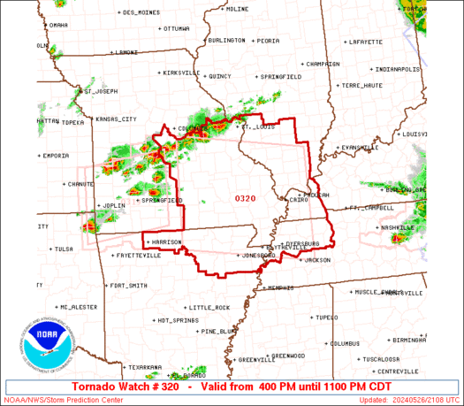
URGENT - IMMEDIATE BROADCAST REQUESTED Tornado Watch Number 320 NWS Storm Prediction Center Norman OK 400 PM CDT Sun May 26 2024 The NWS Storm Prediction Center has issued a * Tornado Watch for portions of Northern Arkansas Southern Illinois Western Kentucky East-Central and Southeast Missouri Northwest Tennessee * Effective this Sunday afternoon and evening from 400 PM until 1100 PM CDT. ...THIS IS A PARTICULARLY DANGEROUS SITUATION... * Primary threats include... Several tornadoes and a few intense tornadoes likely Widespread damaging winds and scattered significant gusts to 75 mph likely Widespread large hail and scattered very large hail events to 3 inches in diameter likely SUMMARY...Intense supercell thunderstorms will continue to develop across the watch area through this evening. Several tornadoes are likely, some of which are expected to be intense. Very large hail is also likely, along with the risk for potentially significant damaging wind gusts. The tornado watch area is approximately along and 90 statute miles north and south of a line from 45 miles north northwest of West Plains MO to 20 miles southeast of Paducah KY. For a complete depiction of the watch see the associated watch outline update (WOUS64 KWNS WOU0). PRECAUTIONARY/PREPAREDNESS ACTIONS... REMEMBER...A Tornado Watch means conditions are favorable for tornadoes and severe thunderstorms in and close to the watch area. Persons in these areas should be on the lookout for threatening weather conditions and listen for later statements and possible warnings. && OTHER WATCH INFORMATION...CONTINUE...WW 316...WW 317...WW 318...WW 319... AVIATION...Tornadoes and a few severe thunderstorms with hail surface and aloft to 3 inches. Extreme turbulence and surface wind gusts to 65 knots. A few cumulonimbi with maximum tops to 650. Mean storm motion vector 28035. ...BuntingQuoteTornadoes
Probability of 2 or more tornadoes High (80%)
Probability of 1 or more strong (EF2-EF5) tornadoes High (80%)
Wind
HailProbability of 10 or more severe wind events High (80%)
Probability of 1 or more wind events > 65 knots High (80%)
Combined Severe Hail/WindProbability of 10 or more severe hail events High (80%)
Probability of 1 or more hailstones > 2 inches High (80%)
Probability of 6 or more combined severe hail/wind events High (>95%)
-
-
2 minutes ago, pen_artist said:
Is anyone able to get an image of this outlook on a county level for N IL?
-
1
-
-
December 22-23, 2004. Couldn't have been more perfect at least for my part of Ohio.
-
4
-
-
1 minute ago, Hoosier said:
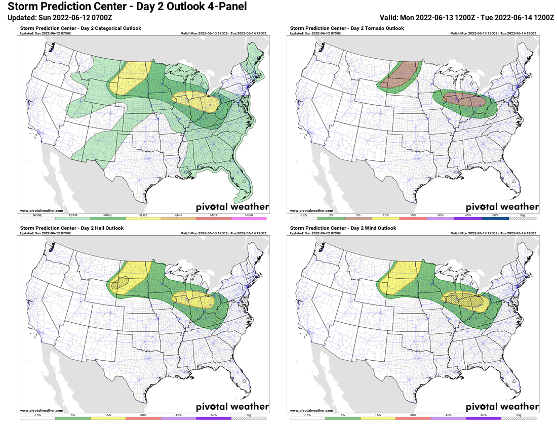
There's a hatched 15% wind area on the day 2 outlook, owing to the uncertainty/varying scenarios but with higher end potential.
Forecast Discussion SPC AC 120558 Day 2 Convective Outlook NWS Storm Prediction Center Norman OK 1258 AM CDT Sun Jun 12 2022 Valid 131200Z - 141200Z ...THERE IS A SLIGHT RISK OF SEVERE THUNDERSTORMS ACROSS PARTS OF THE NORTHERN PLAINS...AND THE MIDWEST/GREAT LAKES INTO THE OHIO VALLEY... ...SUMMARY... Scattered severe thunderstorms should develop Monday across parts of the northern Plains, and from portions of the Midwest into the Great Lakes and Ohio Valley. Large hail, damaging winds, and a few tornadoes all appear possible. Some of the winds could be significantly severe (75+ mph) across parts of the Midwest/Ohio Valley Monday afternoon. ...Synopsis... A large-scale upper trough initially over the western CONUS will move slowly eastward across the Intermountain West on Monday, eventually reaching the northern/central Rockies and adjacent High Plains by late Monday night. An upper-level ridge should persist over much of the MS Valley into the Southeast, with another upper low forecast to remain over Quebec. Enhanced west-northwesterly mid-level flow should be present over parts of the Midwest into the Great Lakes, OH Valley, and Mid-Atlantic on the northeast side of the upper ridge. At the surface, a lee cyclone should consolidate over the northern and central High Plains by Monday evening, with another low over southern Saskatchewan. Rich low-level moisture should return northward across much of the northern Plains along/east of a front extending between the two surface lows. A warm front is also expected to lift northward across parts of the Midwest into the Great Lakes and OH Valley through the day, with a very moist low-level airmass present along/south of the warm front. ...Northern Plains... Modest mid-level height falls and ascent preceding an upper trough should overspread parts of the northern Plains by Monday evening. Diurnal heating of a moist low-level airmass to the east of a front should encourage the development of moderate to strong instability by late Monday afternoon across parts of western SD and vicinity. Strong deep-layer shear of 50+ kt will easily support supercells with any convection that can develop and persist. Most guidance suggests that thunderstorms will initially develop by late Monday afternoon across far northeastern WY/southeastern MT, and quickly strengthen as they spread northeastward across western/central SD and ND Monday evening/night. The rather favorable thermodynamic and kinematic environment will support a threat for both large hail and severe winds with supercells as the dominant mode initially. Some of the hail could be very large (2+ inches) across parts of western SD and vicinity Monday afternoon/evening, as steep mid-level lapse rates and 2000-3000+ J/kg of MLCAPE will likely be present. With time, some upscale growth into a cluster may occur across ND Monday night as a cold front moves eastward. Given the large amount of buoyancy forecast, damaging winds and hail may continue to be a threat even if convection becomes slightly elevated. A few tornadoes may also occur with any supercell, mainly late Monday afternoon and early evening, across parts of western SD into ND as low-level shear increases. ...Upper Midwest into the Great Lakes and Ohio Valley... Thunderstorms may be ongoing at the start of the period Monday morning across parts of the Midwest (IA/MN and vicinity). This activity could pose an isolated severe hail/wind threat as it moves eastward Monday morning. There may be an MCV associated with this morning convection, and some guidance also shows a corresponding mid-level vorticity maximum and enhancement to the mid-level winds. Although details in convective evolution remain unclear Monday afternoon, there is increasing concern that redevelopment of intense thunderstorms could occur with the MCV across parts of southern WI/northern IL into southern Lower MI, IN, and OH. Strong to extreme instability (MLCAPE 3000-5500+ J/kg) will likely develop along/south of a warm front across these areas. Low to mid 70s surface dewpoints, strong diurnal heating, and steep mid-level lapse rates will all contribute to this large reservoir of buoyancy. 35-45+ kt of deep-layer shear should also be present with the enhanced mid-level west-northwesterly flow on the northeastern periphery of the upper ridge. This volatile environment will support significant severe potential with any thunderstorms that can form along/south of the warm front. At this point, there is still a substantial amount of uncertainty with where/if thunderstorms redevelop by Monday afternoon. Both global and convection-allowing model guidance show large variability in possible solutions, which range from little to no surface-based convective redevelopment, to an intense, bowing MCS sweeping southeastward in a narrow corridor across parts of the Midwest into the OH Valley through Monday evening. Given these uncertainties, have opted to include greater (15%) severe wind probabilities and add a significant severe wind area where confidence in an MCS occurring is somewhat better. Isolated large hail may occur with any embedded supercell. A few tornadoes also appear possible, as low-level shear will be maximized along and just south of the warm front. If confidence in the MCS scenario occurring increases, then even greater severe probabilities would likely be needed owing to the very favorable thermodynamic environment. The eastern/southern extent of the severe threat is also uncertain, so have expanded the Marginal Risk across the OH Valley into the central Appalachians to account for a broad range of possible tracks to the MCS before it eventually weakens Monday night. ..Gleason.. 06/12/2022
Beat me to it. That's some pretty strong wording.

-
-
New day 2 mentions EF3+ tornado possible.
QuoteDay 2 Convective Outlook NWS Storm Prediction Center Norman OK 0101 AM CDT Sun May 01 2022 Valid 021200Z - 031200Z ...THERE IS AN ENHANCED RISK OF SEVERE THUNDERSTORMS ACROSS PARTS OF OKLAHOMA AND SOUTHERN KANSAS... ...SUMMARY... A severe threat is expected to develop on Monday over the southern and central Plains eastward into the Ozarks. Large hail, wind damage and tornadoes will be possible Monday afternoon and evening. A marginal severe threat will also be possible across parts of west-central Texas and in the western Tennessee Valley. ...Southern and Central Plains... An upper-level trough will move eastward across the southern and central High Plains on Monday, as a 45 to 60 knot mid-level jet translates eastward through the base of the trough. At the surface, a low will move southeastward into northwest Oklahoma as a cold front advances southeastward across western Kansas and into western Oklahoma. By afternoon, a dryline will setup from a frontal triple point in western Oklahoma extending south-southwestward into northwest and west-central Texas. A warm front will advance northward across eastern Kansas and central Missouri. Surface dewpoints across the moist sector will be in the mid 60s F, where moderate instability is expected by afternoon. Convection is forecast to initiate ahead of the cold front from south-central Kansas into north-central Oklahoma during the late afternoon. Rapid thunderstorm intensification should occur with several clusters of strong to severe thunderstorms moving eastward from central and northern Oklahoma into eastern Kansas during the early evening. Isolated thunderstorms are expected further south-southwest along the dryline into parts of northwest and west-central Texas. The environment across the southern and central Plains may become very favorable for severe storms, depending upon early day activity shifting eastward away from the region. NAM forecast soundings from Wichita southward to Oklahoma City at 00Z/Tuesday are impressive loaded gun soundings. MLCAPE is forecast to be in the 2000 to 3000 J/kg range, with 0-6 km shear from 50 to 60 knot. This is combined with 700 to 500 mb lapse rates near 8.0 C/km, and 0-3 km storm relative helicities of 450 to 500 m2/s2. This will be a high-end parameter space very favorable for supercells with large hail, wind damage and tornadoes. Hailstones of greater than 2 inches in diameter will be possible with the more intense supercell updrafts. As low-level shear ramps up during the late afternoon and early evening, tornadoes will be possible with the more intense supercells. Model forecasts show a strong low-level jet response across northeast Oklahoma. Supercells that develop to the west and northwest of the low-level jet should be associated with a threat for strong tornadoes, and an EF3+ tornado may occur. In addition, wind damage will be possible with supercells, and with organized short bowing line segments. A severe threat should develop south-southwestward into northwest Texas and west-central Texas to the east of the dryline, but convective coverage will be more isolated there. Large hail and wind damage would be possible with supercells that form in the late afternoon and early evening.
-
49 minutes ago, Indystorm said:
Seems to be a bit of confusion at NWS Chicago. "Radar confirmed" tornado warning issued for the Oak Brook area and shortly thereafter cancelled. Was there an actual touchdown? Tag said "observed."
It was radar confirmed which means there must have been debris showing up and it could have been brief leading to cancelation.
-
Quote
BULLETIN - EAS ACTIVATION REQUESTED Tornado Warning National Weather Service Chicago/Romeoville 449 PM CDT Sat Apr 30 2022 The National Weather Service in Chicago has issued a * Tornado Warning for... East central DuPage County in northeastern Illinois... Central Cook County in northeastern Illinois... * Until 515 PM CDT. * At 449 PM CDT, a tornado producing storm was located over Oak Brook, moving northeast at 25 mph. HAZARD...Damaging tornado. SOURCE...Radar confirmed tornado. IMPACT...Flying debris will be dangerous to those caught without shelter. Mobile homes will be damaged or destroyed. Damage to roofs, windows, and vehicles will occur. Tree damage is likely. * This tornadic storm will be near... Westchester, Northlake and Hillside around 500 PM CDT. Elmhurst, Maywood, Bellwood and Broadview around 505 PM CDT. Other locations in the path of this tornadic thunderstorm include Melrose Park, Forest Park and River Forest. Including the following interstates... I-88 between mile markers 137 and 140. I-290 between mile markers 13 and 20. PRECAUTIONARY/PREPAREDNESS ACTIONS... This Tornado Warning replaces the Severe Thunderstorm Warning issued for the same area. -
25 minutes ago, pondo1000 said:
Maybe a couple clippers in our future?
Could be something Wed night/Thursday that's been shifting north some and currently showing some snow along the Ohio River area.
-
1
-
-
Got a little more than 2" here in Dayton. That west outer band was a nice surprise.
-
1
-
-
Got around an inch here. This outer band is a nice surprise.
-
3k NAM still snowing in C/E Ohio. Northern energy snow showers in IN.

.thumb.png.fe96966d37f7b5a7e7eedf62cf946a20.png)
-
0z NAM continues the trend of the 18z Euro.
-
24 minutes ago, buckeye said:
18z euro nice shift west
-
1
-
-
Quote
.LONG TERM /FRIDAY THROUGH TUESDAY/... Deep, but unphased, troughing will be positioned near the NE coast of the CONUS for the start of the period with NW flow aloft over the OH Vly transitioning to more quasi-zonal flow through the day on Friday. The final day of the workweek will have the region squeezed between the system exiting the eastern seaboard and the next one in line, which will be progressing quickly from the Upper Midwest to south-central plains Friday into Friday night. By this time, attention will be squarely focused on the second of the aforementioned systems -- the one tracking almost N-S through the central plains on Friday. Longer-range guidance remains in relatively good agreement showing this midlevel S/W transitioning to a closed low by Saturday morning in the vicinity of KS/OK. This feature will be responsible for a rather impressive band of wintry pcpn on the NE periphery of the track, which will likely position itself from MN to MO during this time period, with the ILN FA & OH Vly staying pretty confidently to the east of any pcpn through the daytime on Saturday. Cannot completely rule out a few flurries, perhaps, near/south of the OH Rvr by later Saturday evening, but the guidance trend in taking this feature further west has left us with pretty high confidence in a dry Saturday here locally as highs ranging from the mid 20s to lower 30s (N-S, respectively) locally. This is a complex winter system that will likely evolve from the ArkLaTex region E/NE through the TN Vly and eventually into the NE CONUS from Saturday night through Sunday. While it seemed like previous data runs had all but written off any notable impacts locally, the latest trends, both deterministically and from an ensemble perspective, suggest this perhaps may not entirely be the case. GEFS/GEPS/EPS ensemble means have all taken considerable jumps further to the NW with the boomerang re-curvature of the system from the northern Gulf to near/west of the spine of the Appalachians before eventually the primary energy transfers closer to the coast, with the inland low becoming somewhat orphaned by later Sunday. There are several things to break down regarding potential accumulating wintry pcpn locally late Saturday night through Sunday. The first, and perhaps most important, aspect will be the timing of the transfer of energy from the initial inland low to the coastal low sometime between Saturday night and Sunday night. The prevailing guidance would suggest occlusion of the initial sfc low in MS/TN Saturday night with the development of a secondary low toward SC by Sunday morning. The occlusion of the low would signal a gradual loss of baroclinicity associated with the inland low, which guidance suggests may track from TN NE through the ern OH Vly during the day on Sunday. The occlusion of the LL system, prompting the loss of baroclinicity, due in part of the lack of arctic air building in quickly from the NW, suggests a gradual decrease in lift/LL convergence associated with any banded pcpn. In fact, there would likely be frontolysis underway with this system as it tracks closer to the ILN FA Sunday, leading to uncertainties in just how widespread and/or intense any wintry pcpn may be. There is no sharp temp gradient or strong frontogenetic axis to work with here, especially as the coastal low becomes the primary one on Sunday with explosive cyclogenesis occurring in the mid-Atlantic region. With all of this being said, it cannot be ignored the obvious and sudden shift to the NW with the inland low tracking to the NE near/west of the Appalachians -- a climatologically-favorable track for accumulating snow in the OH Vly. Although there remains some positional variability that will ultimately play a significant role in the evolution of the system and potential impacts locally, this trend has shown itself almost unanimously across the GEFS/GEPS/EPS ensemble quites. Most guidance would suggest that the column may get /just/ warm enough to promote a mix of rain/snow during the afternoon in N KY and south-central OH, with the predominant p-type remaining snow elsewhere with a subzero (C) profile and ample saturation in the DGZ coinciding/overlapping with some vertical motion with the mid/upper level low tracking through the region. Ensemble mean probabilities continue to suggest increasing potential for light accumulations of snowfall (1"/3") or less near/SE of the I- 71 corridor on Sunday. These ensemble means do assume a 10:1 SLR, which would likely just a bit higher than we would be dealing with (we may be closer to 8:1 or 9:1, depending on location). Nevertheless, the trends with the overall closed low tracking further to the N/W, with implications on the track of the inland (filling) low, have raised PoPs above the blended guidance for Saturday night through Sunday and will introduce a broad-brushed HWO mention for now. Certainly we are still several model runs away from being able to hone-in on whether this system will be more of a nuisance, or perhaps a bit more significant, so we will continue to adjust the forecast as trends and patterns dictate. Another "kicker" S/W will pivot SE from the Upper Midwest to the OH Vly immediately behind the "main" system for Sunday night into Monday morning. This system may have enough additional lift to generate some snow showers during the day on Monday as temps remain several degrees below seasonal norms. Have not added slight chance PoPs yet for this time period as confidence remains low at this time in the exact track and strength of this feature. But some lake- effect/enhanced snow showers N of the immediate local area seem like a good bet at this juncture for the start of the workweek.From ILN
-
12z GGEM finally loading and it looks very similar to the GFS.

.png.9a95d00e972f68dbfb0919e409fac5a4.png)
May 17th-20th severe weather discussion
in Central/Western States
Posted
Tornado Warning
KSC097-190330-
/O.NEW.KDDC.TO.W.0009.250519T0248Z-250519T0330Z/

BULLETIN - EAS ACTIVATION REQUESTED
Tornado Warning
National Weather Service Dodge City KS
948 PM CDT Sun May 18 2025

...TORNADO EMERGENCY FOR GREENSBURG...

The National Weather Service in Dodge City has issued a

* Tornado Warning for...
  Northeastern Kiowa County in south central Kansas...

* Until 1030 PM CDT.

* At 947 PM CDT, a confirmed large and destructive tornado was
  observed near Greensburg, moving northeast at 30 mph.

  TORNADO EMERGENCY for GREENSBURG. This is a PARTICULARLY DANGEROUS
SITUATION. TAKE COVER NOW!

  HAZARD...Deadly tornado.

  SOURCE...Weather spotters confirmed tornado.

  IMPACT...You are in a life-threatening situation. Flying debris
           may be deadly to those caught without shelter. Mobile
           homes will be destroyed. Considerable damage to homes,
           businesses, and vehicles is likely and complete
           destruction is possible.

* The tornado will be near...
  Greensburg around 955 PM CDT.

PRECAUTIONARY/PREPAREDNESS ACTIONS...

To repeat, a large, extremely dangerous and potentially deadly
tornado is ongoing. To protect your life, TAKE COVER NOW! Move to an
interior room on the lowest floor of a sturdy building. Avoid
windows. If in a mobile home, a vehicle or outdoors.. Move to the
closest substantial shelter and protect yourself from flying debris.

Tornadoes are extremely difficult to see and confirm at night. Do not
wait to see or hear the tornado. TAKE COVER NOW!

&&

LAT...LON 3751 9939 3773 9932 3767 9904 3749 9928
TIME...MOT...LOC 0247Z 221DEG 25KT 3753 9931

TORNADO...OBSERVED
TORNADO DAMAGE THREAT...CATASTROPHIC
MAX HAIL SIZE...2.00 IN