

JoshM
-
Posts
3,167 -
Joined
-
Last visited
Content Type
Profiles
Blogs
Forums
American Weather
Media Demo
Store
Gallery
Posts posted by JoshM
-
-
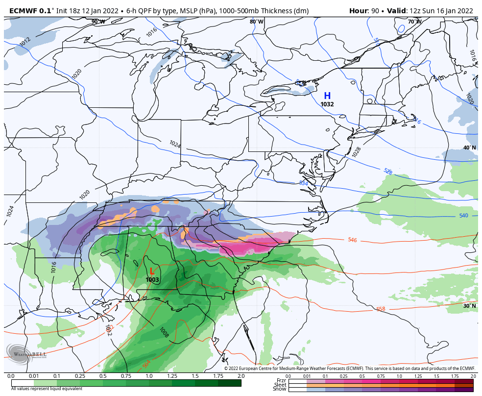
6z gfs is an I-85 ice storm . Over 3/4 inch for KCLT, MBY (Gaston/Cleveland county line) gets close to 1 inch
-
 1
1
-
-
1 minute ago, lilj4425 said:
Is it over yet?
-
 2
2
-
 1
1
-
-
Just now, buckeyefan1 said:
It's a constant 24 hours all day every day

I've been on this board over 10 years and I wonder why I have no hair left.
-
1
-
2
-
-
18z GFS gives me .79 inches of ZR. Looks like I'll be getting rid of some trees, whether I want to or not
-
18 minutes ago, lilj4425 said:
It’s the hard knock life for us. It’s the hard knock life for us.
For MBY I can smell the ice already. Getting a little nervous
-
2 minutes ago, Jonathan said:
Wow, what an absolute dumpster fire train wreck the Euro is...unreal. holy trucking buckets it's bad.
That’s a nasty ice storm for CAD areas around I-85
-
1 minute ago, HKY_WX said:
About 24 hrs from sounding the warning bell on the ice. Really has nasty potential.
Even if you cut the totals in half, it's still a historic ice storm for the CAD areas.
-
0z GFS has Charlotte at 2.02 inches of ZR

-
Too bad euro ends at 90hrs, that’s a weenie run

-
5
-
 3
3
-
-
6 minutes ago, buckeyefan1 said:
Ya'll!! I'm sooooo freakin excited!! It's been a loooooooong month of watching, telling everyone including myself to be patient and stalking every single change as it broke down the pattern, but we are tracking an actual winter storm and there is another on the horizon!!


-
1
-
-
Just now, buckeyefan1 said:
Ya'll!! I'm sooooo freakin excited!! It's been a loooooooong month of watching, telling everyone including myself to be patient and stalking every single change as it broke down the pattern, but we are tracking an actual winter storm and there is another on the horizon!!
You brought all the mojo!!!

-
1
-
-
Charlotte is the "winner" this time with 1.68 inches of ZR
-
10 minutes ago, 85snowline said:
Hey guys... A Storm can create it's own cold air right?. What's that called and could we see it with this storm? Thx
Yes, the "making it's own cold" would come from the ULL on the backend.
-
Just now, weatherguysc said:
I sure hope not. I'm beginning to wonder if the 6Z got a bad data ingest because of how crazy the low moved around.
I haven't seen a situation with a low thru TN like that and a CAD holding on that strong. Still a long ways to go

-
1
-
-
Just now, weatherguysc said:
Lights out for weeks/months for the upstate of SC if that comes true.
Ya, I'm good on that. If the track keeps moving west I don't see how the CAD would hold for that much ZR.
-
1
-
-
Nearly 2 inches of ZR for GSP and 1.5 for CLT

-
1
-
1
-
-
6z GFS is a mess


-
1
-
-
Funnily enough, the heart of the CAD area is colder compared to 12z

-
18 minutes ago, wncsnow said:
With that much CAD it wont be pretty for someone in the ZR zone
Ya... It's lights out for the CAD areas, literally and/or figuratively
-
Canadian following suit

-
1
-
 1
1
-
-
Well… guess I’ll come hang out over here.

-
Awaiting the 0z runs…
-
2 minutes ago, Buddy1987 said:
Boy the 0z Canadian is REALLY trying as well to make this super interesting looking at 5h around the 114hr mark. Not nearly aggressive as the gfs but nonetheless another scenario to look over.
Indeed, looking good


-
We're already getting the weenies and noobs showing up. Everyone buckle up, it's gonna get rough

Jan 15-16 Winter Storm
in Southeastern States
Posted
I sure hope so, 2002 flashbacks are coming to mind.