

LP08
-
Posts
3,290 -
Joined
-
Last visited
Content Type
Profiles
Blogs
Forums
American Weather
Media Demo
Store
Gallery
Posts posted by LP08
-
-
Nam with some negative changes early out west with the vort more west.
-
25 minutes ago, WinterWxLuvr said:
I agree. But I’ve been trying to “see” why that is happening. Perhaps it’s the changes up over Hudson Bay that are bumping it west. I don’t know. It also appears slightly stronger.
GFS for roughly the same time.

-
3 minutes ago, WinterWxLuvr said:
I agree. But I’ve been trying to “see” why that is happening. Perhaps it’s the changes up over Hudson Bay that are bumping it west. I don’t know. It also appears slightly stronger.
Has to be the TPV there. Its hard to track that thing on the various models because it truly does wobble around and its very inconsistent clicking through everything.
-
2 minutes ago, WinterWxLuvr said:
I’m scrolling run after run trying to discern a difference in what’s happening out west and can’t really find anything. Only hope I have is that this is so delicate out there that meaningful changes there wouldn’t be that hard to have.
I'm not the smartest but look at the trend of the last 5 0z/12z runs with the SW through MT. It dives in further west each run. This broadens the long wave trof and keeps it more positive as it moves east before the next NS vort phases. This causes the first one to "stretch" and get left behind.

-
 1
1
-
-
NS definitely better divining into the trof there...if we could just kick out more the Southern wave.
-
 1
1
-
-
Euro the last several runs has been correcting the initial NS SW further west as it dives into Montana. This broadens the trof as it comes east.
-
Snowy Friday afternoon and evening.
-
2
-
-
It seems like every time the NAM has a good run, the RGEM looks worse from its previous run and vice versa.
-
Crazy how slowly it crawls up the coast as H5 closes off.
-
2 minutes ago, DDweatherman said:
Doesn't look all that far off from 0z at 54 if we're being honest. Better than 6z no doubt, but also not much worse than 0z
I'd argue the trof looks very close to 0z.
Edit: Just a little more broad
-
Just now, stormtracker said:
out to 45. It's obvious it will be better than 6z for sure.
NS diving in is west of 6z and a hair stronger than 0z. Southern Stream looks like its splitting the difference between 0z and 6z.
-
I see some minor positive changes through 36 on the NAM compared to 6z.
-
TPV over eastern Canada was further south and west and was tilting the trof more positively. That allows the southern vort to stretch.
-
1
-
2
-
-
1 minute ago, pazzo83 said:
i'm seeing they were up 8 with :34 left? JFC.
Minus the fact they were up 35 at one point.
-
Good god that wizards loss.
-
 1
1
-
 1
1
-
-
Further west and sharper Trof…woof
-
4
-
-
Through 27 on the NAM. NS Sw maybe a hair east of 18z. No real changes elsewhere.
-
1
-
-
1 minute ago, stormtracker said:
Yup. I saw it coming at 78, but I didnt say shit because who knows...shit could have bounced off the outerbanks like a ping pong ball and im not brave enough to predict what happens after a model ends.
Easy. H5 closes off, tucks off the delmarva. We all win.
-
6
-
-
998 south of OBX...lets try that.
-
3
-
-
-
5 minutes ago, jaydreb said:
These...seem odd to me that the max strip is is SE from NC to up the Coast.
-
It's 3-6 hrs away from being really good.
-
2
-
-
Just now, DDweatherman said:
Disagree, digging in a bit further west
The first one through MT.
-
Only minor but the NS SW is diving in a little further east than 6z.


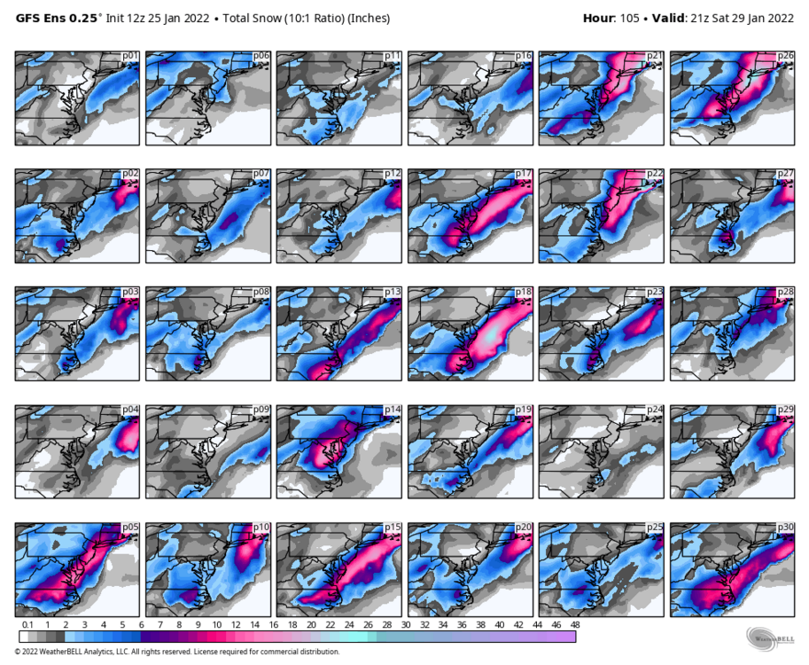
January 28-29, 2022 Miller abcdefu Storm Threat
in Mid Atlantic
Posted
Through 36...well...lets just track the ULL snows lol