

LP08
-
Posts
3,290 -
Joined
-
Last visited
Content Type
Profiles
Blogs
Forums
American Weather
Media Demo
Store
Gallery
Posts posted by LP08
-
-
Just now, WxWatcher007 said:
Yup building ridge to the north just traps it. Of course, that’s the furthest out and least confident part of the forecast.
Crazy part is that's Monday! Went from no storm at all at 12z yesterday to a Cat 1-2 landfall coming in 3.5 -4 days. I don't envy forecasters. What a very complex and tricky set up with the different interactions.
I know the forecast discussions have been harping it but for the general population, could be quite a shock to wake up to hurricane watches potentially Saturday morning.
-
 2
2
-
-
Pretty cool trends...unfortunately gets stuck in SC

-
3
-
-
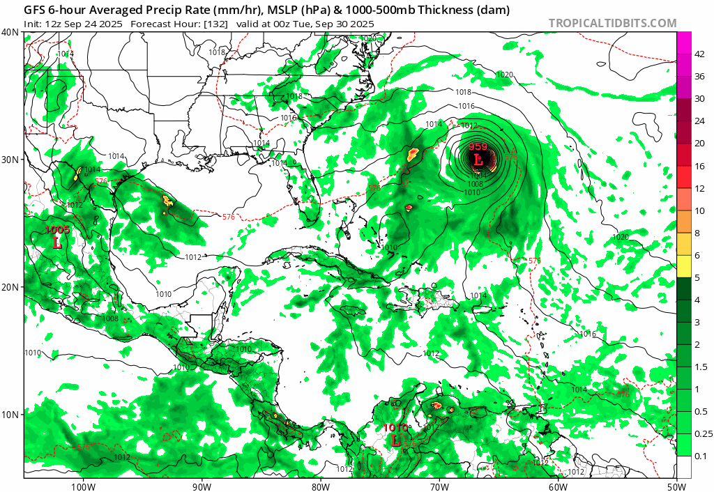
12z GFS shows a weaker Umberto and stronger future Imelda through 72. Has more rain Saturday Night into Sunday than 6z...
-
1
-
-
6z EURO is very wet Saturday afternoon into the overnight.
-
1
-
-
0z euro would up the fun meter vs the last several months.
-
2
-
-
Euro with 2-3" of rain through Monday. GFS less than 1"
-
11 minutes ago, Eskimo Joe said:
The Euro / ICON would be a nice drought stopper. Not too much rain to flood anything out, but enough to put us back in the right direction.
GFS says what rain? Develops 93L and recurves and does very little with 94L
-
58 minutes ago, WxUSAF said:
Euro all of a sudden really into rain late Saturday into Sunday.
ICON as well now.
-
53 minutes ago, aldie 22 said:
For some reason I wasn't upset at how the game started for the Vikings i just figured JJ was so new it is going to take time. The defense was solid and with the score still close i started to think some guys just win even when its ugly. Once the momentum shifted i knew it was on. Who knows how the rest of the season goes but 1-0 is better than 0-1. Caleb Williams has talent but I don't think he's him.
Not a Bears fan but read somewhere this morning that when he is pressured and starts to run, he doesn't look like he has control of his arms and legs. Just complete panic and I kinda laughed thinking back at watching it, lol.
Commanders are so lucky JD5 was there at 2. -
Just an insane amount of lightning over here in Arlington. Non stop.
-
2
-
-
3 minutes ago, mappy said:
Just warned
One of the better couplets of the day..
-
That one south of La Plata looks close..probably needs a warning soon
-
3 minutes ago, Solution Man said:
Fwiw

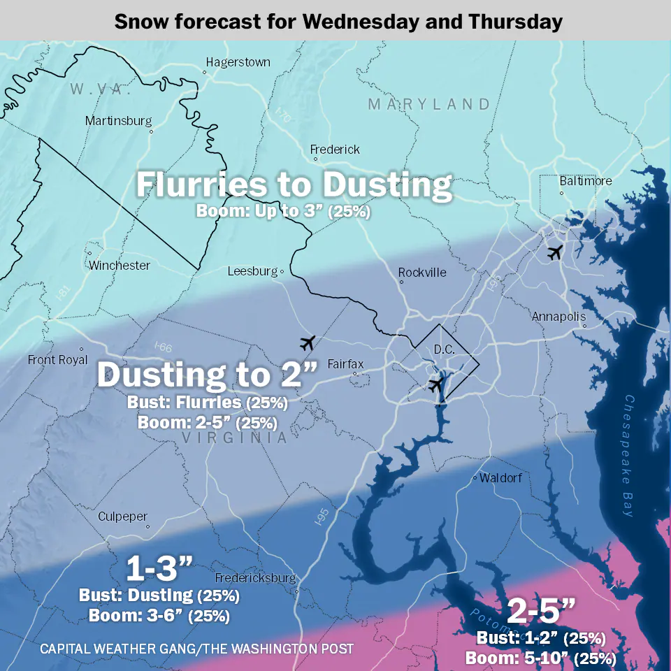
Be easier to do just one color, say 25% and say 0-10
-
 1
1
-
 1
1
-
-
2 minutes ago, stormtracker said:
NAM looking a tad bit flatter out front. Let's see how this ends up
Not as strong with the SS and little more disconnected from the NS…it’s time
-
3 minutes ago, stormtracker said:
This is gonna shock you all, but so far the GFS is....the same
Minor positive changes which should help Richmond and our southern friends.
-
2
-
-
4 minutes ago, high risk said:
We should all acknowledge as a group that, even if the NAMs are spectacularly wrong on this event, we’re going to miss them like deceased grandparents when they’re retired next year.
They should run it still on some black site just for us.
-
1
-
2
-
-
Icon was a nice bounce north and stronger for our Richmond peeps.
-
5
-
-
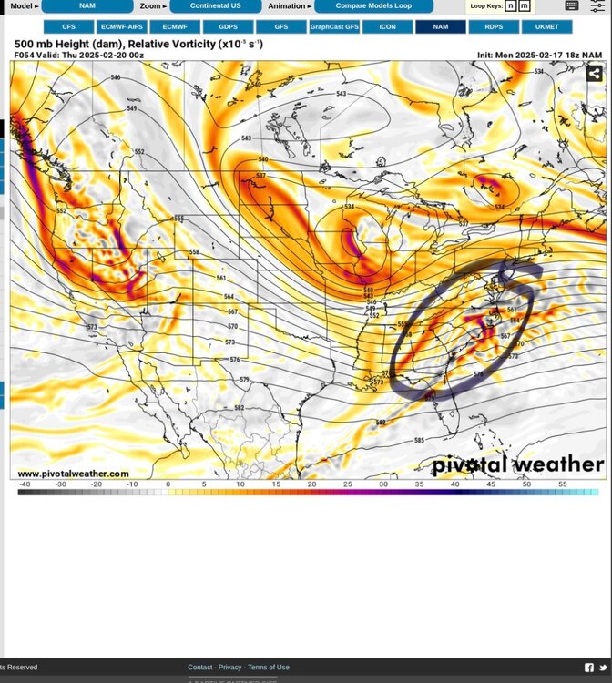
Scrolling through…at 42, NAM is the ONLY model that keeps any semblance of the southern stream SW.
-
1
-
-
Positive changes out west with the GFS. Probably won’t mean much up here but for our Richmond friends.
-
1
-
-
Nam and euro at H5. Nam keeps the SS sw more in tact and euro washes it out east.

-
2
-
-
Nam keeps the SS sw in tact while the euro completely washes it out. That’s really the only difference I can tell.
-
Someone post the NAM clown. Kuchera has the 6 line like 12 miles from dc.
-
1
-
-
NAM had better interaction out west early on with the streams.
-
3 minutes ago, Bob Chill said:
There's a bias in play here. Gfs/gefs was getting ripped when it was weak and disorganized while the euro was going big. It was assumed to be wrong and would catch on to the euro. I looked at if different. To me it was a consistent warning sign that a cohesive storm had some problems. More that one.
It seems like a model collapse when consensus showed the northern piece being a thorn instead of a boom. But there were plenty of warning signs not to jump on the boom bandwagon and I never did. Never doubted an OK storm, but those big totals never seemed real to me.
I'll say this, this place would be a lot more fun if people would stop marrying mid range high end fantasy stuff. Anything less is unacceptable but less is a near certainty.... time and time again over and over lol. The majority of our storms are looked at with turd colored glasses come gametime because of this. Even when it produces what's expected in the short range.
Also. As I’ve been here a long time and definitely have grown up more. Still stings but I don’t try and bring everyone else down with rapid fire posts of despair. I just go punt furry creatures.
ps. Nam better
2025 Tropical Tracking Thread
in Mid Atlantic
Posted
12z Euro into Wilmington, NC. Not much rain for the Saturday Night - Sunday morning deal but better trajectory for impacts from Imelda.