

weatherwiz
-
Posts
71,754 -
Joined
-
Last visited
Content Type
Profiles
Blogs
Forums
American Weather
Media Demo
Store
Gallery
Posts posted by weatherwiz
-
-
Very nice inverted-V look on soundings later today with as much as 125+ J/KG of 3km CAPE. Could see quite a bit small hailers with some pretty gusty winds. Perhaps a severe gust possible.
-
8 minutes ago, It's Always Sunny said:
I think seeing mid-level lapse rates pushing 8.0C/km is more fascinating than the t-storms you'll be getting tomorrow as exciting as that is too.
I agree with this haha...always love me some mid-level lapse rates approaching 8. Not common around here
-
Another vigorous shortwave moves overhead during the day Monday with extremely unseasonably cold temperatures aloft yielding very steep mid-level lapse rates. Combination of surface heating and dewpoints into the 40’s will contribute several hundred J/KG of MLCAPE.
inverted-v signature on forecast soundings indicate potential for strong, gusty winds with any thunderstorms while the super cold air aloft will promote potential for small hail/grauple.
-
Thanks!
wow not bad at all up there! I was definitely hoping/I guess leaning towards the CCB cranking earlier. Guessing CT didn’t get much in the way of anything?
-
Are there any PNS statements or snow total maps? Didn’t see anything on NWS pages.
-
Happy birthday @CoastalWx @RUNNAWAYICEBERG
-
 1
1
-
-
4 minutes ago, Ginx snewx said:
Euro is very squally 400 to 500 joules of Cape
yup...that's a pretty significant amount of CAPE for this type of setup. I'm surprised SPC doesn't have a general thunderstorm risk out
-
Just now, Ginx snewx said:
Kevin made some comment about no snow squalls tomorrow. I will take the over
yeah tomorrow is going to be nuts...strong gusty winds, cold, snow squalls with grauple!!!!
-
Well after this we can finally turn our attention to severe wx season. It's coming!!!!!

-
 1
1
-
 3
3
-
-
22 minutes ago, CoastalWx said:
Looked a little weaker. Slowly getting the idea.
It was fun while it lasted
20 minutes ago, Amped said:That may be the best chance. Really starting to lose confidence in the weak CCB.
Those squalls are nasty. Insane lapse rates, and plenty of dry air at 900mb. Perfect ingredients for the squalls making their own cold air. GFS showing 500 SBCAPE with temps in the 30s to low 40s.
Yeah Saturday afternoon it going to be winter-like...cold temperatures, gusty winds, squalls...it's going to be a pretty crazy day
-
Well this weekend was cute but after this it's back to reality...should be tracking severe wx...like a snow event would be super fun but it's severe weather season damn it
-
1
-
-
4 minutes ago, Amped said:
It caved quite a bit at 500mb and with the surface low track and intensity.
At least Saturday afternoon is still in the cards...going to be numerous squalls with grauple and strong winds. Going to feel like December out there
-
GFS holding it's own regarding getting the CCB going
-
Doesn't seem like the NAM wants to phase...if it were to phase it would probably be a solid hit. So I guess we just have to decipher what the odds of a phase are and if there is a phase how quickly does it happen?
-
 1
1
-
-
Just now, Damage In Tolland said:
Not according to your map
my map was predominately NW Hills and NE Hills for any meaningful accumulations (4-6'' up in northern Litchfield County) then a strip of 2-4'' across larger part of that county and then up your way
-
10 minutes ago, Ginx snewx said:
Wide open looking for the Windsexyness
yeah let's not overlook Saturday afternoon...which was actually the original purpose of the thread before the snow threat evolved

Too be honest more people could see some sort of frozen throughout the day Saturday then Friday night.
-
48 minutes ago, The 4 Seasons said:
can you send me the link to this. I used to have it but i dont know what i did with it.
-
Euro cranks that CCB in ME...wow
-
This is some pretty crazy mixing for around here

-
1
-
-
Even better!!! Can't overlook Saturday afternoon either
-
Just now, CoastalWx said:
I need to look back, but I don’t think it was phasing as much? I just glanced at 500. My experience just says guidance is usually not in good agreement even 60hrs when it comes to late season cyclogenesis. The last few storms have been true to this. I think the reasons above all help to combine. Hopefully the euro helps settle it.
That's what my initial look was...it wasn't phasing as much.
-
This is pretty nuts...decent clustering between 0-1'', however, also several members going wild!!

-
2
-
-
Just now, CoastalWx said:
It’s real hard to get a wrapped up low this time of year unless dynamics are insane. You do have good dynamics and thermal gradients in this instance....but it’s not the same as winter. Plus convection can affect the moisture transport to wrap around.
maybe that's why the NAM isn't as wrapped up with this?
-
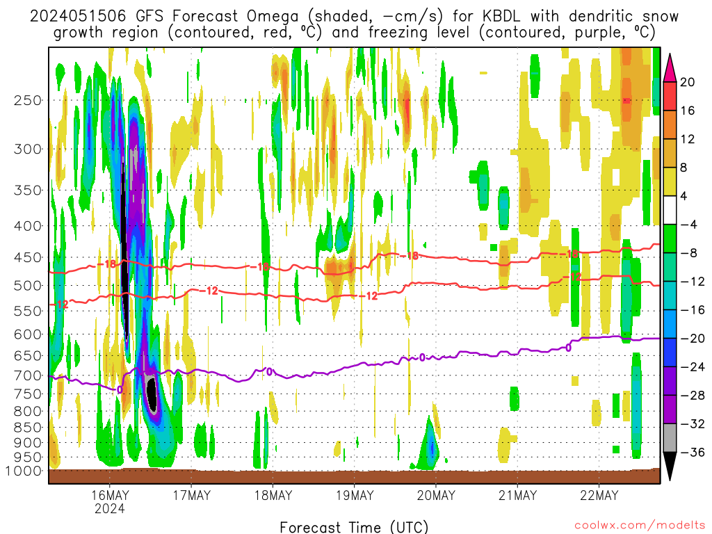
This was the 6z GFS...can't wait for 12z but also look at early Saturday afternoon...definite signal for either snow squalls or like grauple/hail showers mixed with snow...hahahaha
-
1
-

Monday, May 11, 2020 Gusty t’storms
in New England
Posted
Actually grauple is probably more likely given the super low WBZ heights