
weathertree4u
-
Posts
974 -
Joined
-
Last visited
Content Type
Profiles
Blogs
Forums
American Weather
Media Demo
Store
Gallery
Posts posted by weathertree4u
-
-
6 hours ago, Carvers Gap said:
Would suspect that power companies across the region will be putting teams together to discuss scenarios. I know the ice storm we had in 1994, the county finally had to provide protection for the president of the electric company.
-
 1
1
-
-
5 hours ago, Carvers Gap said:
Seems like wherever this ends up it will not be pretty.
-
1
-
-
3 minutes ago, Olhausen said:
Honestly I love cold and snow but I want no part of this. That ZR would be devastating for my town and my business in Portland Tennessee. The cold temps that followed is what really scares me. The one problem is that middle Tennessee is absolutely due for a devastating ice storm. I have lived here since 2006 and have always been able to avoid the worst during ice storms.
I live in same area. The Woodlands still show the scars of the last really bad one we had in 1994
-
2
-
-
34 minutes ago, John1122 said:
The 06z GFS is insane.


That is not good. That would cause serious hardship for days across the region
-
3
-
-
NWS Nashville typically pretty conservative is mentioning next week in discussions. I lost track of the winter events depicted on morning run of GFS for forum
-
1
-
-
8 minutes ago, Carvers Gap said:
Great.
Middle and West folks have not really seen anything this season so my skepticism is warranted.
-
1
-
-
16 minutes ago, Carvers Gap said:
12z EPS has moved towards the good look that the 12z GEPS has. GEPS is a true 95-96 look. EPS is not far off that mark. GEPS start date is around d11 and EPS is around d14. Both basically open up a path from AK(super cold temps) into the lower 48. Realistic look and I would lean in that direction if forced to pick. Guessing the GEPS has this as the EPS is probably holding back just a hair in the West which is a known bias. Good trends from those two ensembles.
Honestly believe it when it is within 72 hours
-
2
-
-
Seems like allot of cold air lurking but no mechanism to pull it south
-
3 minutes ago, Holston_River_Rambler said:
Some of the EPS member progression from days 10 - 15 are so nice. Here are some samples:
There were more too and even some of the misses were not rainers, but suppressed storms. There were some rainers in there too. None of these solutions is likely "The" solution, but at least some hint at what could be possible if the block develops nicely.
Looks great to me, sure beats last few seasons lol
-
3
-
-
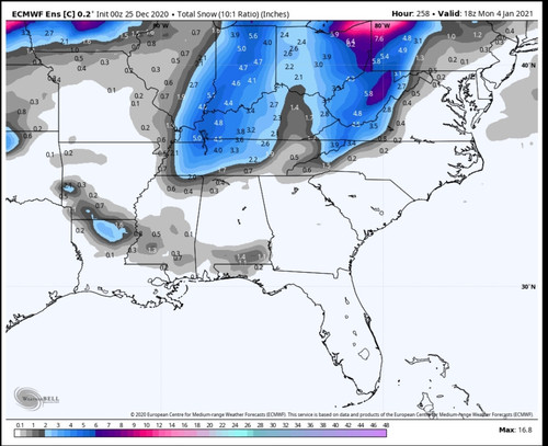
5 minutes ago, Holston_River_Rambler said:
I absolutely cannot wait to see the Control's precip. panels for this time period.

West TN/KY do well - something to track!
-
2
-
-
On 12/25/2020 at 9:42 AM, AMZ8990 said:
Saw that too, very sad man. It’s unfathomable that there are individuals who would carry out something so terrible. Thoughts and prayers to all affected
Finally back on line after nearly 48 hours
-
4
-
-
5 minutes ago, John1122 said:
Uncle lol thanks
-
1
-
 1
1
-
-
1 minute ago, John1122 said:
Shoot, it looks great to me. The indices scream winter. The mountain torque event is starting similar to the one that gave us the PNA boost to close out November. The Euro is consistently showing a low road storm in the 8-10 day period. The EPS has a decent mean around that time frame. The Canadian has hinted at a big storm around then too. Late in the Euro's run basically all of southern Canada was in the-15 to -20 range. That's great source air for us.
I'm usually very skeptical after the past few winters sunk us. But this winter seems to have way more potential than any we've had since 2016 or so.
All right, will be more on board when start seeing it depicted in modeling I guess.
-
1
-
-
9 minutes ago, John1122 said:
Merry Christmas, fellow weather enthusiasts. I believe I've "known" some of you guys for nearly 15 years now. Even those of you who've not been around as long, I'm glad to see you here every day. 3 or 4 inches of snow on the ground today is like 10 any other day. We only get to experience this in our back yards once every 8 to 15 years depending on where you live.
To our west valley folks, hopefully we are just at the beginning of a prolific winter. We aren't getting extremely cold yet or anything but this system just shows that sometimes timing is all it takes. Hopefully your window comes open during this rare -NAO/-AO combination. If the Pac cooperates as advertised during the first two weeks of January, I think you'll get some fireworks. 80-85 percent of the seasonal snow that falls in the region falls beyond December. So a ton of winter left.
Will remain hopeful but not really seeing allot on modeling that can cling too lol
-
Glad some in the forum area were able to score, not seeing allot in the long range that would indicate the pattern we need. Could be wrong, hoping so!
-
1
-
-
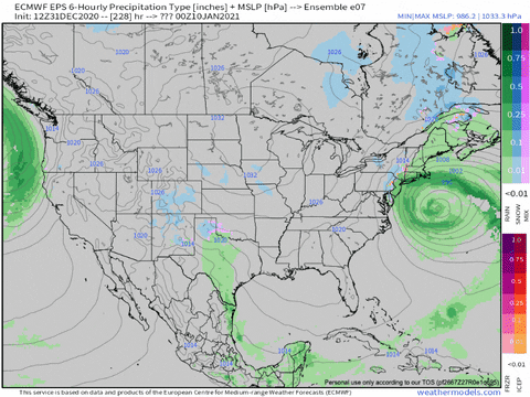
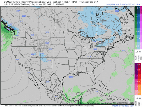
5 hours ago, Carvers Gap said:
Today's GEFS extended 35 day snow totals below. Also, take a look at the 18z CFSv2. It(CFSv2) bounces around quite a bit, but nice run for January. Anyway, the GEFS extended has snow all of the way to the Gulf Coast. I think that means a trace(or more) of snow would fall in all of the lower 48 by late January. If the advertised pattern verifies, there is a chance this has some merit. Huge grain of salt though as always at this range! Also, I do like this as it gives a good idea of where the storm tracks might be.....

The CFS that just ran was insanely cold and snowy for the entire state but especially so from Middle to East TN; I like winter but that run would not be good for the area.
-
Just now, John1122 said:
I'd say we are about 12z runs today away from starting a thread for the Christmas event. It's been consistent on modeling for days and the event is getting close to moving onto HI-Res model territory.
I am just pleased to see something to track this season!
-
5
-
-
49 minutes ago, John1122 said:
MRX playing it cautious. Basically the standard "well, it's probably going to snow in the mountains." disco. Can't really blame them though they did put out a giant graphic yesterday talking about a wintry Christmas.
Nashville doing the same, pretty standard operating procedure, usually play it ultra safe often times - Nashville - not calling for accumulating snow until they see it snowing and accumulating lol
-
32 minutes ago, Holston_River_Rambler said:
It's SEC championship Saturday, and you know what that means...
Happy Hour GFS is at 6z!
On a half way more serious note, guess which model had that more wound up/ cut off southern solution yesterday at 12z???
J
M
A
Although I have to say the Canadian had a similar solution for a while, but for a different reason. The 0z CMC has a triple phaser, just a wee bit too far west and north to be optimal for us.
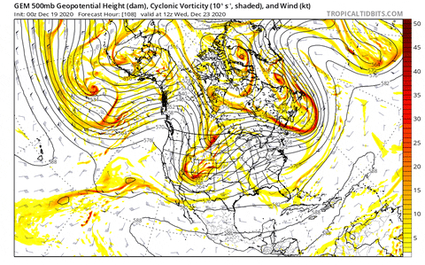
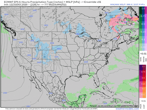
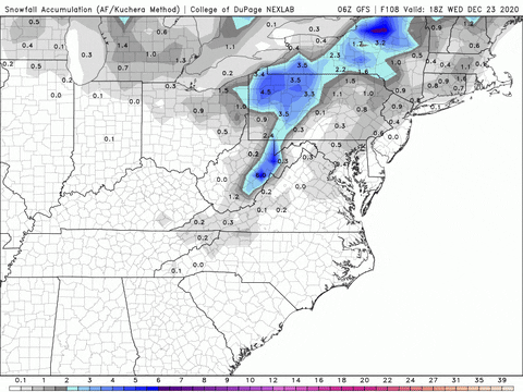
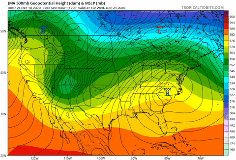
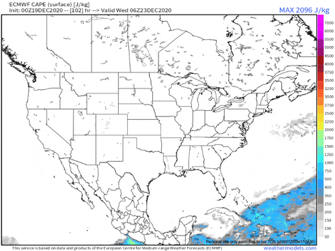
Man the overnight Euro was ugly, like y'all said. It even gives us a tiny little bit of CAPE and a lot of shear:
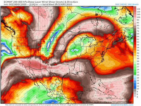
Hopefully the Euro is overamping that initial push of energy (although following weather weenie rule 35 tnweathernut reminded me of yesterday, probably not). But it has overamped some systems in this range in the past month. I can't find the images, but at one point the Euro had, in this time frame (around hour 120), a wound up storm dumping snow on middle TN. It ended up less wound up, but that doesn't mean it will this time.
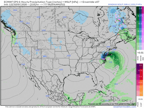
It's actual depiction of the energy looked closer to a better solution and if you discount the wound up energy heading to the lakes, it isn't too far from the GFS or CMC:
Notice the piece of energy I circled. It closes off a secondary piece of energy to our south. Of course the same rule I applied to the first piece that closes off (above) could also be applied to this piece. If it is overampy, maybe it is overamping both.
I say let's go for the WPC's idea, for now:
"While the amplifying evolution is a consistent and agreeable theme in the guidance, the details are still fairly uncertain. If anything the new 00Z guidance is lowering confidence somewhat given a return to more spread for exactly how Eastern Pacific shortwave energy reaching the West evolves in the short range/early medium range time frame, with the 00Z UKMET/CMC not comparing particularly well with recently established consensus. To some degree these issues feed through the rest of the period. Interaction from Canadian flow provides added complexity. Among the 12Z/18Z solutions the GFS/ECMWF/CMC clustered fairly well in principle, suggesting steady progression of the northern tier system and then one or more waves (possibly with fairly strong development) embedded along the trailing front that crosses the eastern U.S. Another surface low could form in the vicinity of the Great Lakes (or elsewhere nearby) based on these solutions closing off an upper low. Ensembles show greater spread including hinting at some potential for slower shortwave energy such as what the new UKMET/CMC suggest, while keeping the overall upper trough open. For the purposes of a single deterministic forecast, preference sided with an operational 12Z/18Z model blend (more emphasis on the GFS/ECMWF) for about the first half of the period and then some inclusion of the 18Z GEFS/12Z ECMWF means to tone down the GFS/ECMWF/CMC specifics given the detail uncertainties farther out in time."

Overall, I like the look of the next few days. Not really seeing anything like the last several seasons, which, even if dont get a good snow, is so refreshing!
-
1
-
-
7 minutes ago, John1122 said:
06z GFS looks good for all but the West valley with two rounds of snow. This is where we end up with the Christmas eve thumping plus the Christmas night clipper.

American modeling is the last to the party but hopefully this will come into clearer focus over the weekend. As a kid I can recall several times where arctic boundaries really over performed in snowfall!
-
2
-
-
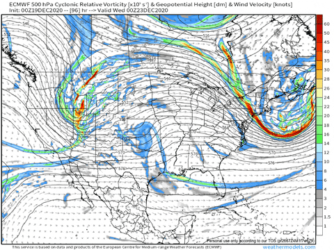
1 minute ago, John1122 said:
And for people who like to just check here. That Canadian mauler that stalls the Arctic front and lets a low ride the front that thumps the middle valley areas then changes to snow in the East as the Arctic air continues to invade. In circumstances like this with that nice a cold air source. I've found the cold usually bleeds further east than modeled. I'd love to see this one be the one that comes to pass because it really works out for the entire forum.
This is about mid-event. It hammers western areas before this and further eastern areas get in on the action after this.


Next couple of days this system should come into better focus in the modeling but already appears there is at least some agreement of some type of system next week followed by colder temps.
-
2
-
-
1 hour ago, John1122 said:
The Euro cooks up something for Christmas eve as well. It's not the epic bomb that was the Canadian but it throws out some biting cold and anafrontal snow due to the strength and speed of the Arctic air mass. There's hardly even any rain, most of the precip except for the very leading edge is frozen. The Euro ends up here and it may be higher with ratios. Many of us would have a shimmering blanket on Christmas morning. Not much of any melting either as temps go from single digits and teens into the low to mid 20s to lower 30s.

The Canadian has a similar setup but favors more of a west - middle TN area
-
4
-
-
6 minutes ago, Holston_River_Rambler said:
Is Sandy Claws a comin' to town? Is he bringin' his old Polar magic with him?
0z Dec. 25th:
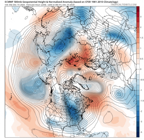
We dont want super cold - wont that shunt all the systems south of the TN Valley?
-
Most all of the seven day forecast for the Nashville area is below averages, at least for hi temps, for January, very strange.
-
2
-
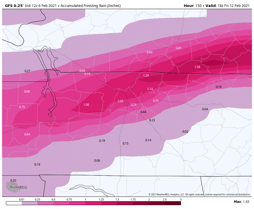
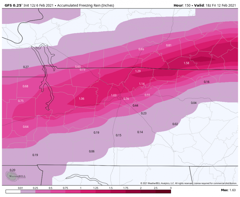
2/14- 2/16 Winter Storm and Arctic Cold
in Tennessee Valley
Posted
I think OHX is finally recognizing thg he boundary continues shifting south