

MGorse
-
Posts
2,260 -
Joined
Content Type
Profiles
Blogs
Forums
American Weather
Media Demo
Store
Gallery
Posts posted by MGorse
-
-
6 hours ago, The Iceman said:
Did it overheat?
HVAC failure.
-
 1
1
-
-
1 hour ago, LVblizzard said:
South Jersey is basically screwed out of radar data for awhile. Eastern PA can use CCX and LWX so they at least have something.
There is the TPHL radar out of Philly International Airport, which hopefully is still operating.
-
98 here yesterday then topped out at 100 today. At least the ridiculously high dew points eased today.
-
 2
2
-
-
1 minute ago, mattinpa said:
I saw the language in that tornado warning used “large and destructive” describing the tornado. Hope everyone is ok. Looks like worst action is south of me.
I am pretty sure that wording was in error. There has been no confirmed tornado.
-
3
-
 1
1
-
-
Took a walk this evening around the neighborhood and it is like Fall.
-
3
-
 1
1
-
 2
2
-
-
After two showers this afternoon, the second one was heavy and gusty, picked up 0.49 inches. Total now of 1.53 inches. Temperature has dropped to 56!
-
1
-
-
1.04 inches of rain.
-
1
-
-
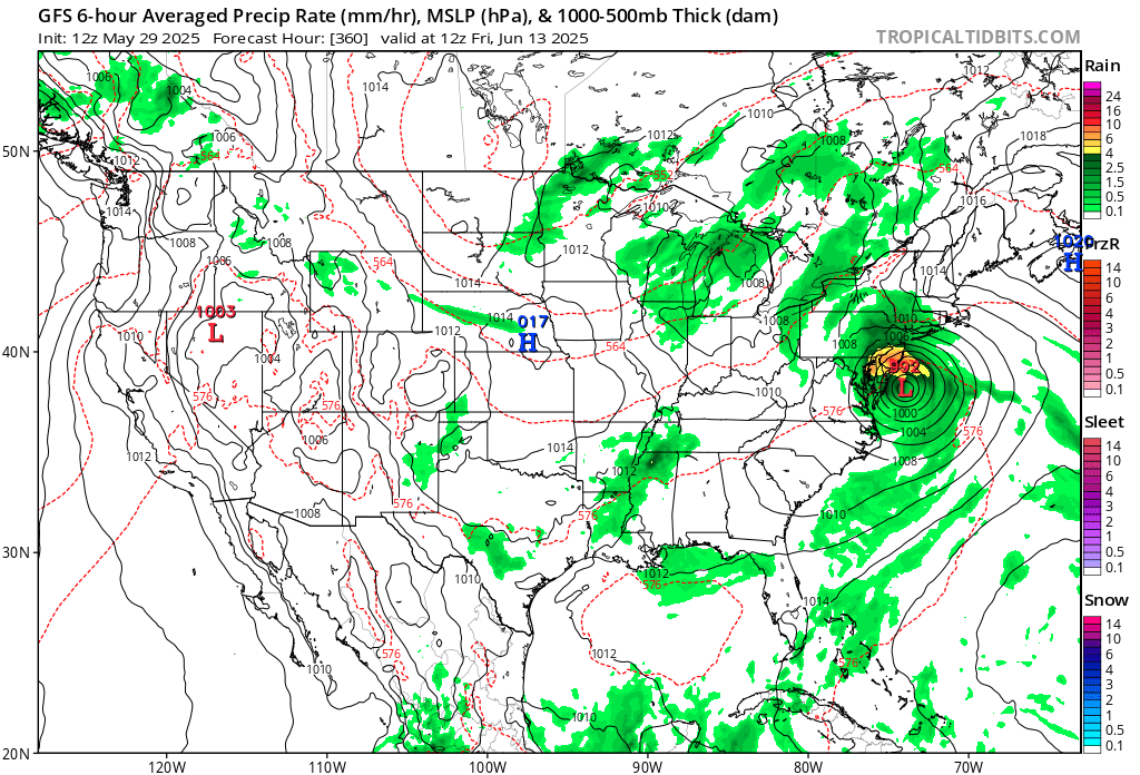
1 hour ago, RedSky said:
Hurricane remains just what the ground needs in June lmao

Hour 360.
-
1 hour ago, Albedoman said:
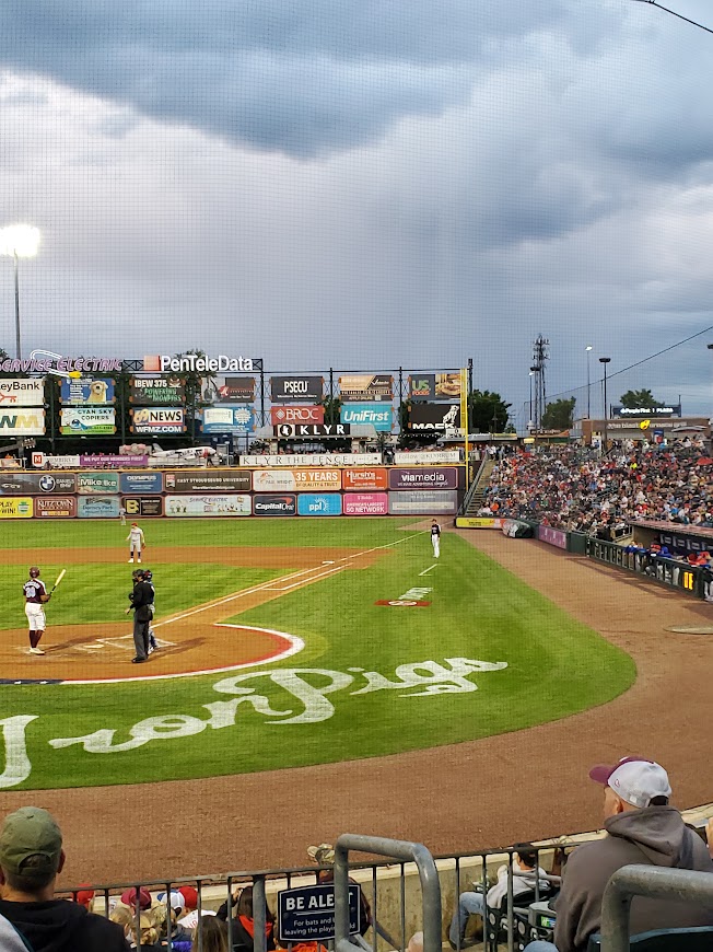
I attended the Iron Pigs game last night. Cold unstable air mass showers popping up throughout the game. Observed three rainbows with one of them being a double rainbow. However, if you look directly over the US foods advertising board, in these photos in right field, there appears to be a cold air funnel forming with the cold unstable air mass in place. I would like Mike and his team to look at these photos for verification. It did not appear to be a simple rain shaft but actually appeared to have rotation and looked like a funnel. If this was indeed a cold air funnel, this would be extreme for our area but I would not doubt its formation with this very cold unstable air mass above in late May.

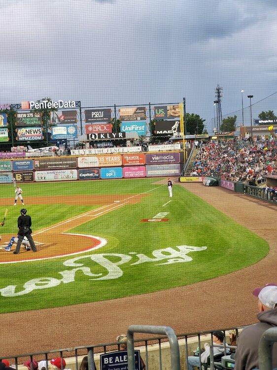
It is possible to be a cold air funnel, but it is tough to tell the details from these photos (plus no video to see any motion). It could also be an enhanced area along the leading edge of the rain curtain associated with the shower.
-
1.15 inches of rain the last couple of days.
-
1
-
-
18 minutes ago, RedSky said:
Another round was on zero guidance what the hell is going on
MCV, which the guidance tends to struggle with.
-
2
-
-
After a quick downpour this morning, total now at 3.11 inches.
-
Finally cashed in! Two day total of 3.05 inches of rain, most of which fell today.
-
5
-
1
-
-
3 hours ago, winterwx21 said:
I'm surprised one hasn't been issued for Middlesex. I'm up to 1.85" and it's still pouring. We're getting training with these downpours.
Not sure how many are aware, but NWS Mount Holly discontinued the issuance of Flood Advisories last year. More focus on the warnings.
-
2
-
2
-
-
Ended up with a whopping 0.16 inches of rain yesterday. Unreal!
-
1
-
-
13 minutes ago, Albedoman said:
well even though Macungie got zilcho rain from this storm, Bangor area in Northampton County got hail and an EF1 tornado that was on video. Tree tops sheared right off and twisted (not straight line wind damage) and no doubt that it was a tornado with hail from this very localized supercell -should have chased that one down. Mt holly storm damage specialists I am sure will out there to inspect tomorrow.
The tornado was not rated yet.
-
0.11 inches of rain the past few days. Yup, that’s it.
-
A whopping 0.03 inches of rain so far.
-
 1
1
-
-
Still dry here. Hopefully some decent rain by later today through Tuesday.
-
Still dry here!
-
0.95 inches of rain at NWS Mount Holly. Dew points have tanked, from mid to upper 60s this afternoon to now down to 39F.
-
1
-
-
0.33 inches of rain today. Better than nothing.
-
1
-
-
On 4/22/2025 at 9:44 PM, Albedoman said:
After being criticized by an individual for not taking a chill pill and for saying the mulch fire was major fire and that I was blowing the fire possibilities out of proportion with the current drought in the last few days, two so called non-major wildfires are still going crazy. Jim Thorpe area over 500 acres and now another non major fire in southern NJ. All I hear now is crickets at my house.
Also Mike Gorse, I must apologize to you and your staff as I did not mean any disrespect toward you or your staff at MT Holly. I am really frustrated with this crappy weather pattern we are stuck in for the past 9 months and did not mean to take it out toward MT Holly staff. Many of the old weather hobbyists have to be as frustrated as I am too as these daily 20-30 mph Santa Ana type winds with extreme diurnal temp ranges and no Gulf of America moisture source for storm convection which has basically has been gone for nearly a year now. I am also hoping a special weather statement will be issued that considers the under-stories in the woods and nearby brushy fields are extremely dry right now regardless of any rain we received two weeks ago. The dry warm winds are sure not helping as evident by these fires. Thanks
https://www.foxweather.com/extreme-weather/jones-road-wildfire-new-jersey-shore-smoke-evacuations
https://www.inquirer.com/news/pennsylvania/jim-thorpe-pennsylvania-wildfire-20250422.html
I appreciate your apology.
-
7 hours ago, Mikeymac5306 said:
I can back him on this as a firefighter. While maybe not a "major" fire. It is quite a nuisance and a burden on the volunteers who have to sacrifice their day just to babysit it and keep dumping water on it.
Those large mulch piles should be moved around often to mix it up to keep it from getting to hot in the middle, thus keeping the fire threat much reduced.
-
1
-

E PA/NJ/DE Summer 2025 Obs/Discussion
in Philadelphia Region
Posted