

MGorse
-
Posts
1,928 -
Joined
Content Type
Profiles
Blogs
Forums
American Weather
Media Demo
Store
Gallery
Posts posted by MGorse
-
-
I dislike this storm!
-
 1
1
-
 5
5
-
-
I wonder if the Winter Storm Watch gets expanded to include at least Berks and Lehigh counties.
-
1
-
-
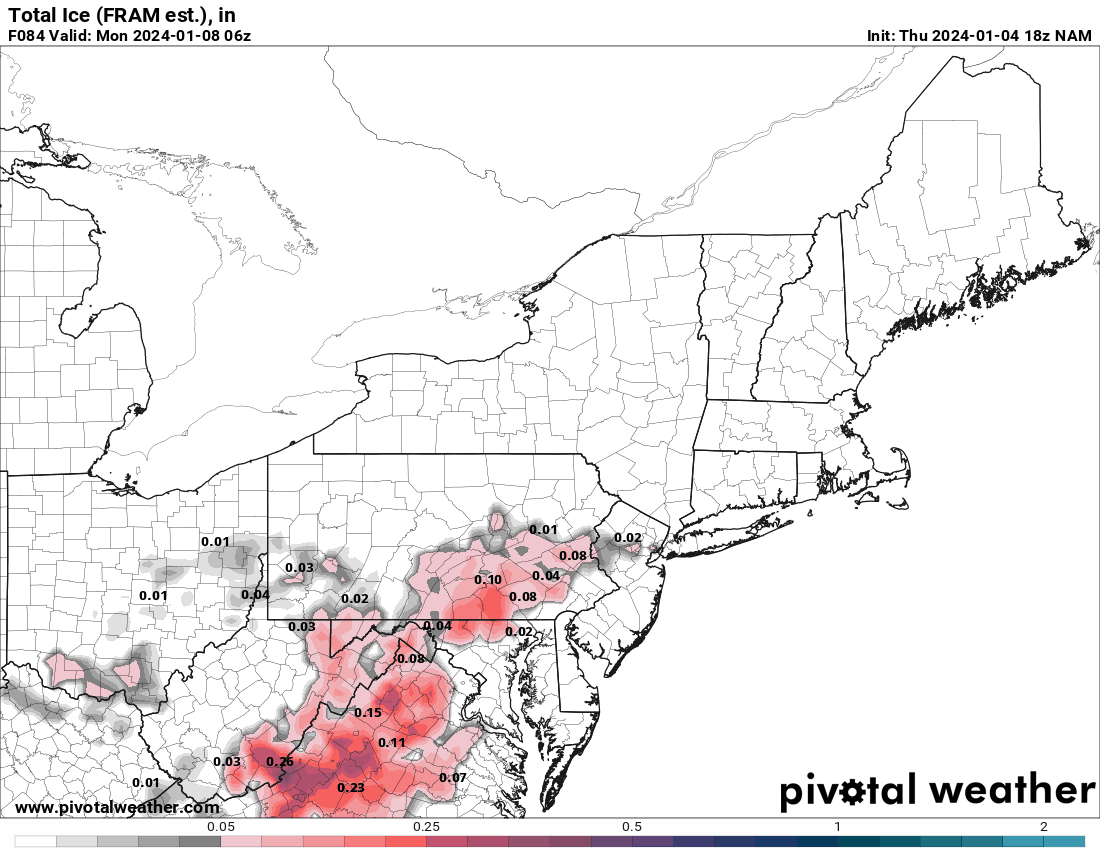
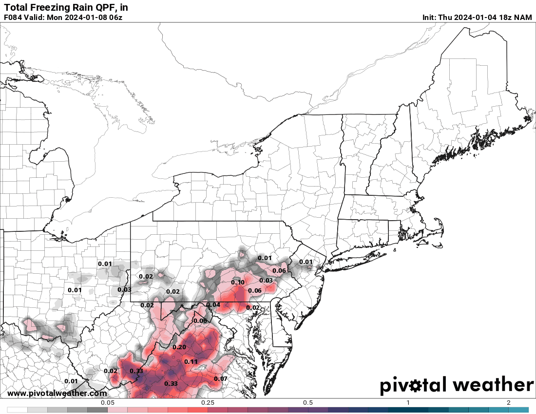
1 hour ago, Hurricane Agnes said:
Note the NAM ice & ZR maps.
18z GFS is running but the 19z NBM ain't buying what the NAM is selling.


Since the NBM is a blend of many models, it won’t completely tip to one model such as the NAM.
-
3
-
-
3 hours ago, Kevin Reilly said:
4-12" LOL quite a spread! I see he still likes Penn State!
T-4” LOL
-
2
-
-
2.25 inches of total rain. If it mixed with or ended as some wet snow, I missed it.
-
1
-
-
I found this site for Mexico radars. Looks like the nearest radar is rather far inland from Acapulco. I think the Acapulco radar is not in service.
https://smn.conagua.gob.mx/es/observando-el-tiempo/radares-meteorologicos-separador/visor-radares-v3
-
1
-
-
After another downpour late this afternoon, my two day total is 3.66 inches. It’s wet!
-
1
-
-
Dumping here. Up to 1 inch for the day and counting.
-
 1
1
-
-
Finally got into the rain action. 0.51 inches today (0.08 inches yesterday).
-
I am just enjoying the anvil clouds now above me from all the convection to my west and southwest.

-
1
-
-
Picked up 0.08 inches. Better than 0.
-
1
-
1
-
-
5 hours ago, famartin said:
Paul… you’re fighting this is tiresome, that’s why the “name calling”. Your data is simply garbage, like most of your related “climate change” posts. I’ve proven that pretty well just now. But obviously you have an agenda. Obviously if your a rich snob in east nantmeal then I guess overall, it doesn’t suck to be you, but your numbers are trash. Too bad, so sad.
Wow Ray!!
-
Still dry here, but at least the outflow blew through and cooled it down significantly. Rain would certainly be nice though!
-
Very eerie looking outside with a yellowish glow.
-
1
-
-
2023 Precipitation Departures from normal (in inches) through 5/27:
Allentown, PA (ABE): -2.37
Reading, PA (RDG): -3.99
Mount Pocono, PA (MPO): -1.48
Philadelphia, PA (PHL): -4.10
Trenton, NJ (TTN): -3.71
Atlantic City, NJ (ACY): -1.68
Atlantic City Marina, NJ (55N): -3.53
Wilmington, DE (ILG): -5.21
Georgetown, DE (GED): 2.06
-
1
-
-
Many trees down in my town (Delran, NJ). The roar was quite evident before the massive wind hit.
-
2
-
 1
1
-
-
52 minutes ago, Hurricane Agnes said:
Last tweet with the summary graphic caps it at 12" up north at the higher elevations -
The 2 feet of snow mention was from much earlier today.
-
11 minutes ago, Albedoman said:
Thanks for checking Mike. Typo?
Not sure and since I did not compose that AFD, I don't want to speculate.
-
1
-
-
4 hours ago, anthonyweather said:

Mt holly is aiming to be the most talked about forecast today. Sadly the state uses this to issue travel bans. What a DISASTER
.Oh I did not realize we had 2 feet mentioned in our AFD. Just went back and saw that. Hmmm
-
1
-
1
-
-
33 minutes ago, jm1220 said:
NWS isn't able to make a warning for anything other than those entire counties, so they have to use that in the language. But what would be more helpful would be to say "2 inches on valley floors and 8 inches on ridge tops".
Farther down in the Winter Storm Warning it states...
* ADDITIONAL DETAILS...Rain or a mix of rain and snow will change
  to snow by later this evening. Some heavier snow is possible
  late tonight and Tuesday morning. The greatest snow totals will
  be in the higher elevations mainly above 1000 feet.
-
4
-
3
-
-
-
I figured I would share this here.
-
Great photo and nice write-up. Congrats!
-
1
-
-
Buffalo airport picked up 5 inches in an hour.
KBUF 200354Z 24008KT 3/4SM -SN BR VV005 M04/M06 A2988 RMK AO2 PK WND 26027/0301 SLP131 SNINCR 5/26 P0013 T10441056 RVRNO $
-
6
-
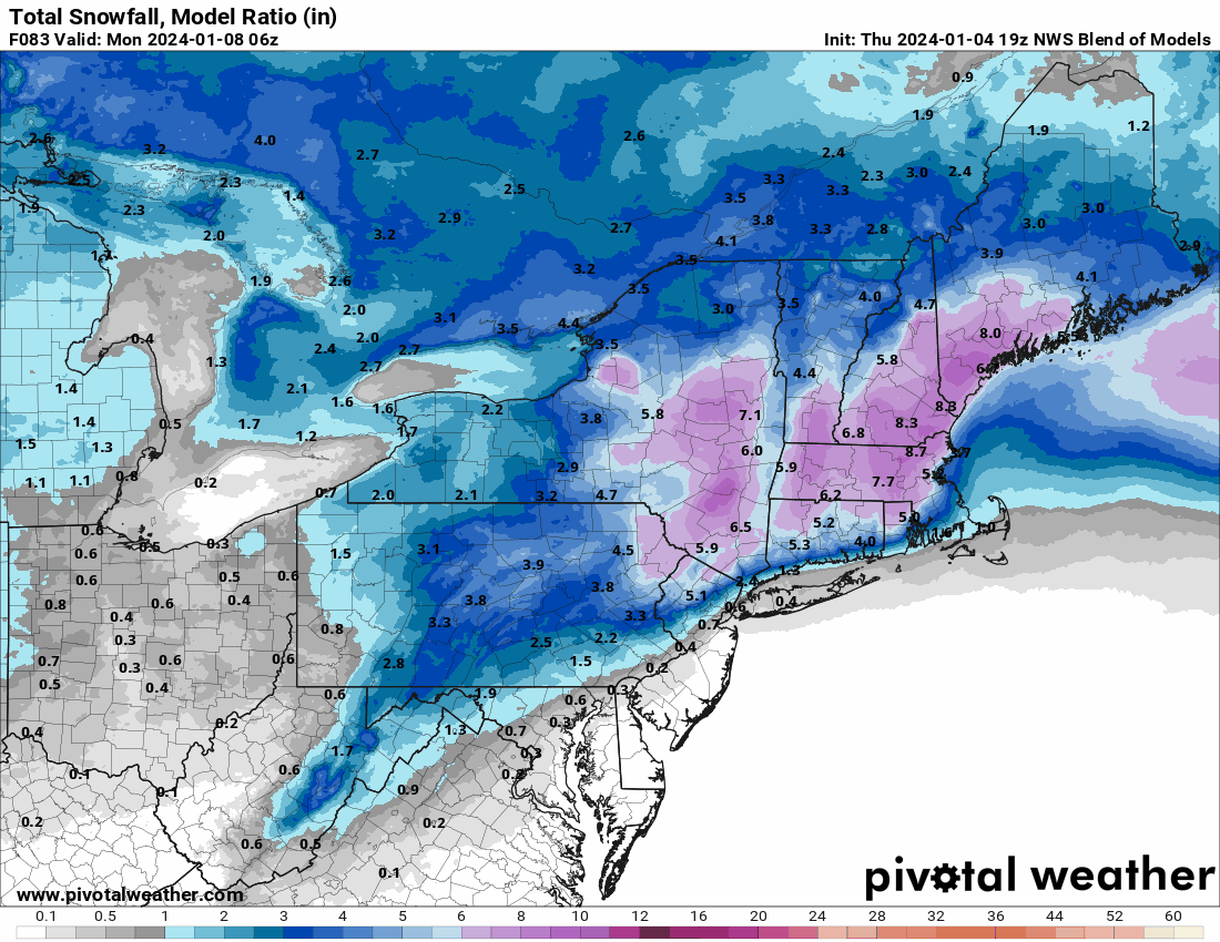

January 6-7 Winter Storm
in Philadelphia Region
Posted
It was 3-5 inches earlier, so not a significant change.