.jpg.82995912781a8a839ab578c3b293f48f.jpg)

weatherbo
-
Posts
6,475 -
Joined
Content Type
Profiles
Blogs
Forums
American Weather
Media Demo
Store
Gallery
Everything posted by weatherbo
-
Beautiful sunny day in the upper 60's with a northeast breeze that made it feel a tad chilly in the shade. Low tonight in the upper 40's with some frost possible in the traditional interior cool spots. Mid 70's to follow tomorrow then a stretch of at least 6 days in the 80's which will be the longest this season. The dog days of summer.
-
Only reached 60 here today with low clouds and fog all day. Looks like a summery pattern setting up late week into the weekend. Currently 56 with fog/mist.
-
Low of 50 last night. Slept with the windows open and woke up at dawn to the robins singing. A few spots fell into the upper 30's-low 40's. Looks like a stellar day with sunshine, limited smoke, low humidity and a high in the low-70's. If not for the deer flies today would be a perfect 10. They have started to wane a bit and shouldn't be an issue in a couple more weeks. August is by far my favorite month of summer.
-
Cool and crisp this morning with a low of 45. Sunny and warm, low humidity, temps in the low to mid 70's today. Some areas close to frost. Champion 36 Baraga plain 35 Stonington 36 Kenton 39
-
Hanging in the upper-50's here early this afternoon after 4 very summer like days with highs ranging from the upper-70's to mid-80's. Had some decent rains as well totaling around 1.5". Not too shabby.
-
Hit 84 here with dews in the low 70's. Def a warm day for the north woods. Nice thundershower has moved through dropping .45" and knocking the temp down to 69 but still very humid with a little fog even.
-
Spent the past week hiking and camping in some of the most remote parts of the Huron's... absolute isolation. A reboot for the heart, mind and soul. Sometimes I feel like I could disappear into the woods forever and be just fine. A warm one today with highs in the mid to upper 80's along with some storm chances overnight as the midway point in met summer is here. In a few weeks tell-tale signs of an aging season will begin to creep in... subtle changes in the leaves, cool foggy mornings, longer afternoon shadows. One of the best times of the year as far as I'm concerned. Nothing better in life than the gift of contentment.
-
Overcast and 59 after just under a 1/4 inch of rain today. High was 62 around 11 am then winds turned northeasterly. Should see mid-70’s tomorrow and a fair amount of sun.
-
Currently 63 degrees after a high of 69 today under mostly cloudy skies after about noon. Not a terrible day but forecast called for more sun than was seen.
-
74/63 currently with a nice breeze. Maybe a rogue thundershower this afternoon. Holiday looking great with sunshine and a high of 72. Active pattern of late is nice in summer.
-
Has its pros and cons. Can be worst climo some months and best climo others. Depends on what you like. I don’t care for heat and humidity so I can tolerate some cool days in the summer. I’m here for the winters and peace and quiet anyway.
-
57 at noon with gusty winds up to 31 mph here at the house. Some light rain has pushed through too. Raw day.
-
I feel like it might have gotten a little cooler than 39 out in my garden. Pepper plants didn't look as good as they had by the end of the day. They are very sensitive to the cold, everything else looked good. Thinking that may be the last real chilly night as the lake is getting warmer and I'm close enough to it to see that influence. This summer tho probably not done with 40's at night. They can be scattered throughout July some years.
-
Chilly morning to usher in the month of July. I had 39 here at my house and an afternoon high of 74. Some rain will be nice the next couple days.
-
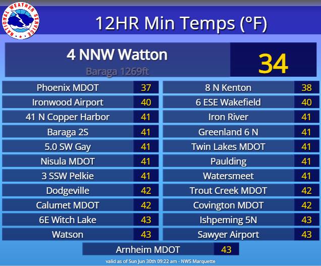
At MQT June finished slightly below average in temp (-0.6) and 5.3" of rain which is 2.03" above the norm. Warmest temp was 86 and the coolest was 35 on the 11th which was also their last frost of the season.
-
64 degrees, a breeze, under full sun. Hard to beat.
.thumb.jpg.5b9f71a817df3f20d49f4baf2bab9fb8.jpg)
-
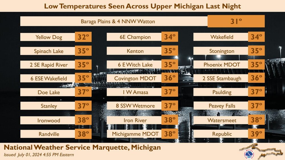
Cool morning 43 here. Mid and upper 30's in the usual spots. Going to be a beautiful day. MQT: Here is a look at our coldest temperatures from last night. We are expecting to be cool again tonight with some spots possibly seeing frost. More updates to the temperature forecast coming soon. #906wx #MIwx
-
Overperformed today with an afternoon high of 77, down to 47 currently with some fog and mist... whiplash weather.
-
Already surpassed the forecast high of 70, 73/66 currently with bit more sun than was expected. A tad humid, maybe a rumble of thunder later. tomorrow looks gorgeous in the low to mid 60’s with ample sunshine.
-
Another cloudy, cool, rainy day yesterday, high of 60. 5.3" for the month at MQT, have only had to water the garden once so far. Maybe some peeks of sun today with a scattered thundershower possible... high around 70 with clearing this evening and an overnight low in the low 40's... mid to upper 30's possible in the colder locations. Sure feels like summer is flying by.
-
Doesn't much matter, it's a very remote area just outside the eastern edge of the Ottawa Nat'l Forest, little to no population, lots of ATV trails, fishing and hunting and that's about it. They're usually the hottest during summer heatwaves and the coolest during ideal radiational cooling nights. I've seen 30's there even in July.
-
Oh for sure. However, a friend and I left out my back door and spent 5 1/2 hours doing an 8 mile hike through the mulligan trail, plains, and the rugged rocking chair lakes. It was a little surreal experiencing legit autumn weather in the mid afternoon hours of an almost mid met summer day. I loved it.
-
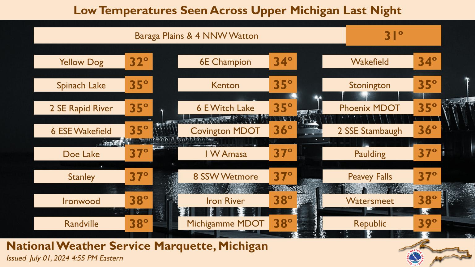
A cool overnight, low of 42. High today with sunshine in the upper 60's. More rain Friday into the weekend. Kenton 37 Stonington 33 Baraga Plains 33 Champion 38 Doe lake 36
-
A backwards day @ MQT in Negaunee Maximum Temperature:64.9°F at 12:00am Minimum Temperature: 49.3°F at 3:45pm
-
Breezy fog/mist, 48 degrees at 4 pm. One of the chillier summer days i can recall in the past couple years. I can see my breath.


.jpg.fa61b88fbc1bd0b69e115bce80cb6931.jpg)