Jenkins
-
Posts
1,421 -
Joined
-
Last visited
Content Type
Profiles
Blogs
Forums
American Weather
Media Demo
Store
Gallery
Everything posted by Jenkins
-
Another East Greenwich lurker (formerly BFF) chiming in here. Moved back here from Charlotte after 5 years down in the snowless piedmont. Looking forward to a decent storm.
-
Punting this pattern change over what the OP GFS spit out at 240+ hours seems like a bit of an overreaction.
-
-
Not able to view any threads again. Like an idiot, I selected the out of date theme.
-
The heavy showers that we have been getting are perhaps cooling the column down faster than the models are expecting. FWIW, 1z HRRR initialized about 3-4 degrees too warm for CLT.
-
Brad P doing a storm update now
-
35 hour output from HRRR is useless.
-
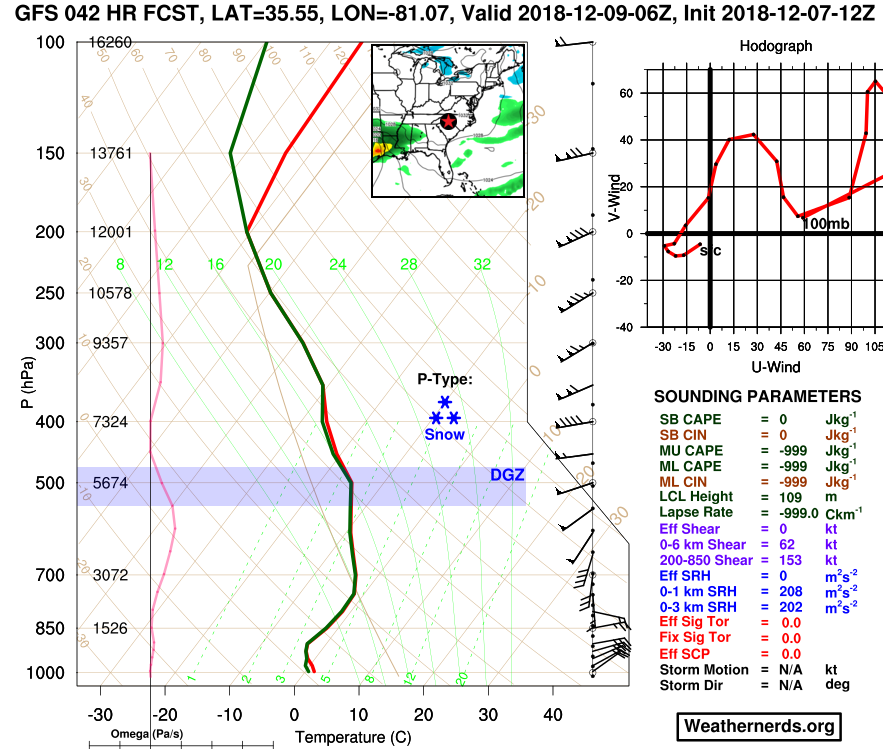
Not a bad sounding right there for CLT at H42. Fully saturated in the DGZ.
-
GSP is discounting the NAM’s thermal profiles: “The NAM is substantially warmer with temps aloft than any of the global models we have at our disposal. For now the NAM profiles are being discounted and not used in the fcst process, not only due to the consensus in the other guidance, but to help maintain better forecast continuity” Also, they are thinking the mountains are going to see a larger percentage of the precip fall as sleet: “"Snow" totals have declined by a few inches over the northern GA/SC zones and in the more western NC mtns, as more of the QPF is now expected to fall as sleet.”
-
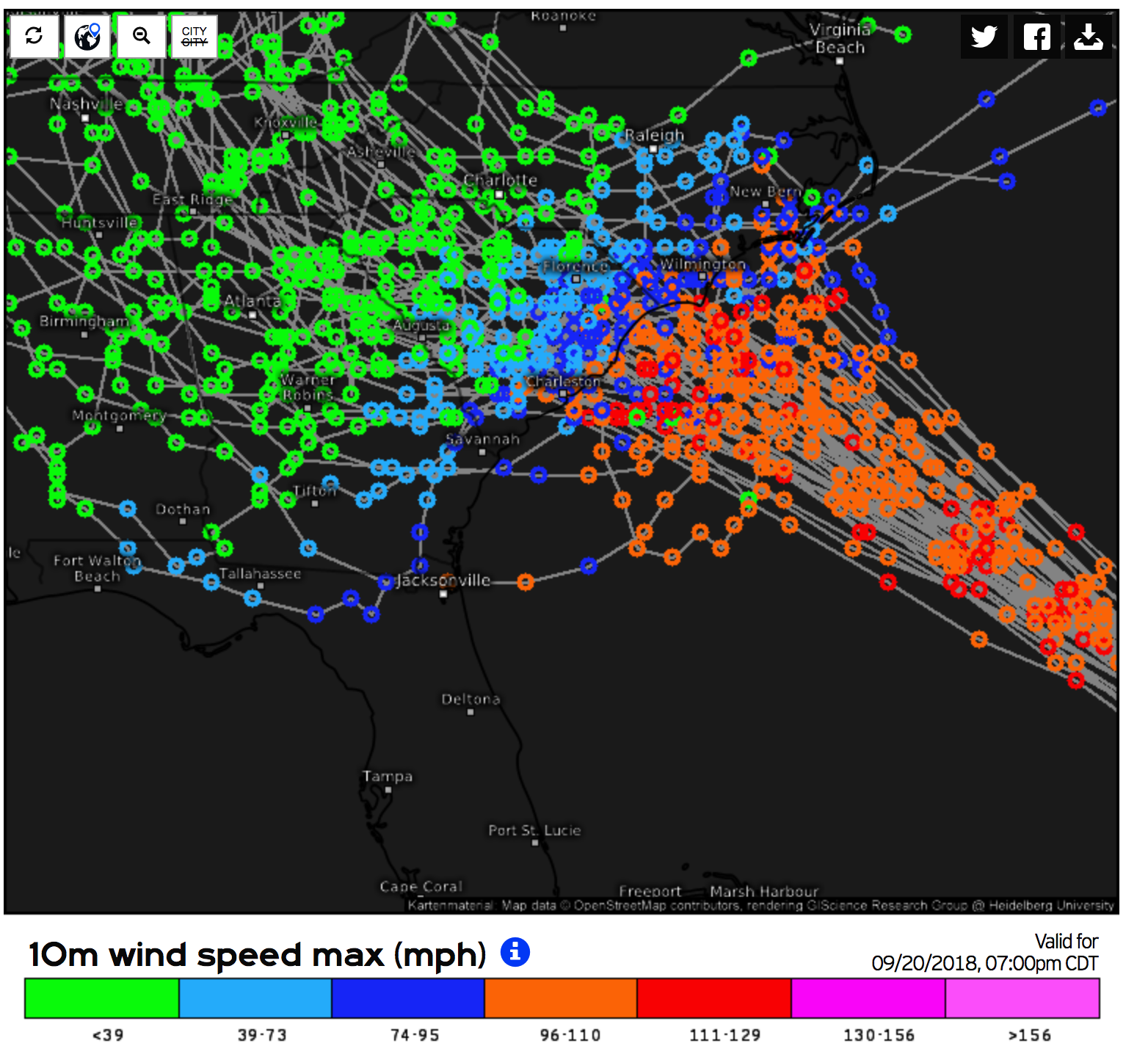
switch to radar (rain/frozen)
-
Believe it or not, there is far more to meteorology than model hugging. Some would do well to bone up on the basics instead of blurting out their IMBY reaction to the latest model run.
-
Brad P's livestream.
-
As natbright posted above, it is from their hazardous weather briefing page. It is located 2/3 of the way down on the left. https://www.weather.gov/gsp/brief
-
-
Speaking of Brad P, he is doing a live stream some time around 8:30.
-
KLTX radar is down. Bummer.
-
Updated from WPC
-
.thumb.png.e6da54fbb940f8fc8e7130c73d1f5afc.png)
-
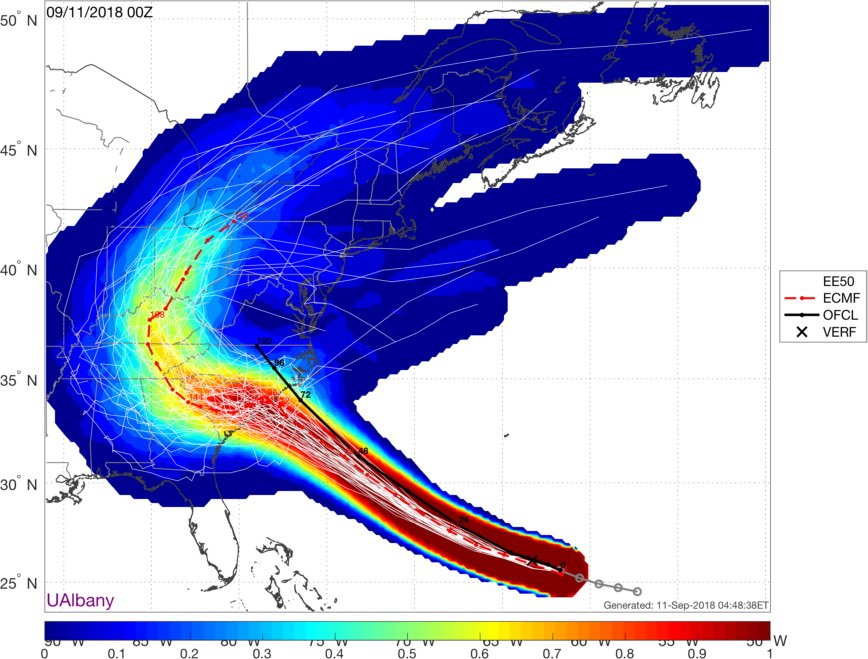
12z ECMWF Track out to 72 hours
-
There will be definitely be some new sandbars that's for sure.
-
That FV-3 run is pretty brutal for both wind and rain impacts in NC/SC. I'll post the precip clown map once it gets out to ~132 hours.
-
FV3-GFS 6z loop
-
Better than my crappy low res shot earlier.
-
https://weather.us/cyclone-tracks/euro/800-w-320-n/2018091100-240-florence.html


.png.18a7b9bd36a0287f22d0bbd293d7c548.png)