
RIC_WX
-
Posts
608 -
Joined
-
Last visited
Content Type
Profiles
Blogs
Forums
American Weather
Media Demo
Store
Gallery
Posts posted by RIC_WX
-
-
At some point, you would think we quit hanging on every model run and acknowledge the seasonal trends, which are what they are. We still have a lot to be thankful for, considering if you told me preseason we would survive all of met winter without a bona fide torch period, I would have thought you were crazy. This now appears to be pretty likely. That is pretty unusual here even in our most prolific seasons. Struggling to recall the last time this really occured.
-
 1
1
-
-
6 minutes ago, Ji said:
i dont want to hit climo....we should be way above it. We have had a -AO/-NAO for 2 months in a row
What did you measure on Sunday morning? Mine melted faster than I could get any kind of measurement with confidence. If the snow was any wetter it would have fallen as rain.
-
1
-
-
Last Sunday the snowblower would not start. So, I bezosed a new carburetor and all is right again. Ran to Berryville for 5 gallons of ethanol free go juice, now we are officially ready for the parade of storms.
-
18 minutes ago, feloniousq said:
A 6.6 inch difference between JYO and IAD is pretty nuts. That's about 2 miles per inch.
I live a mile from JYO and feel confident in a seasonal total between 10"-11"
-
1
-
-
2 minutes ago, mdhokie said:
Im just south of glendale rd and our cove is frozen. People were out there today ice fishing. Not sure how thick but it felt solid
 .
.
We bought some property this past summer off N Glade so close by for sure. Construction is a slow process here, complicated by doing a lot of the work myself. Hoping to be part time residents by summer, was just up for the day to check on some things...looking forward to next winter already.

-
3
-
-
I spent most of the day today around Deep Creek. The lake is definitely trying to freeze over, but the ice is still thin. You get back to brown ground though basically at the Allegany county line, even before you reach Cumberland.
Photo from approximately 1:30 this afternoon, off 219 just south of the bridge into McHenry.

-
10
-
-
42 minutes ago, psuhoffman said:
Hope this doesn't ruin anyones day....but seeing 2002 in those analogs made me think of this. 2002 is a cautionary tale of how much luck plays in all this. 2002 wasn't likely to be good given that about 50% of the winter pattern was garbage (from Jan 20 on). But we actually had a pretty good pattern for a solid month before that...and we just wasted it. We had a dry period in Dec...a storm was suppressed around xmas, then a big storm in early January was just a bit too far north...PA got a foot of snow, then a good overrunning setup really failed to meet potential when the wave sheared out...and we got a minor snowfall. Then the pattern broke down and the rest of winter was garbage. But we should have done better early that winter then we did IMO. If you have a good pattern for a solid month you should avoid a god awful winter like last year when the pattern was mostly garbage start to finish. It's always possible we get a good pattern...and just waste it.
This was probably the height of the blocking in 2002...and this lead to the storm that hit south of us.
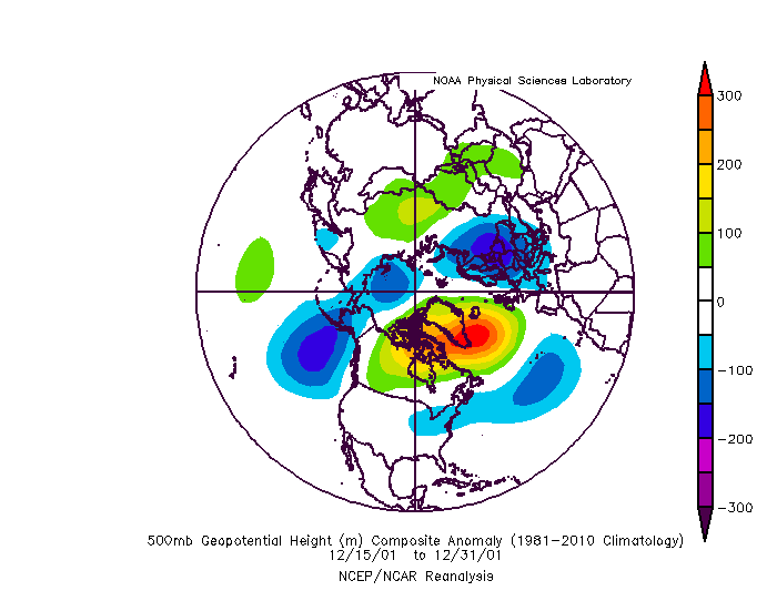
This was the mean from Dec 15 to Jan 15. We should have got more out of this month IMO.
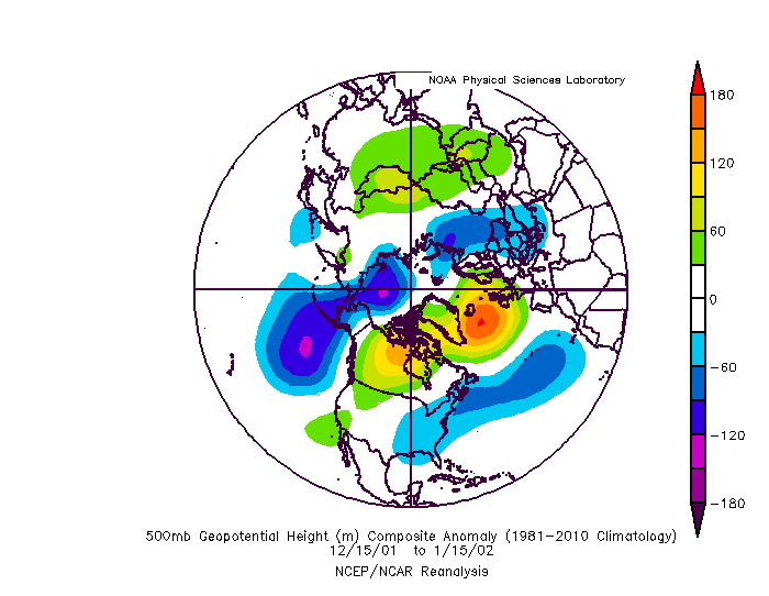
That "storm that missed south of us" hit Richmond between Christmas and New Year, and is the fastest melting snowfall I can remember. It was 80% gone the day it fell and 100% disappeared by lunchtime the next day. It melted faster than it could be plowed off the street. This was a thread the needle setup and unquestionably lucky.
I think more importantly, the summer 2001-2002 period is amongst the driest on record in the mid atlantic, especially VA. This isn't even a little bit comparable to now. Clearly the setup is different even if some teleconnections are similar globally, and assuming all else was equal we would have 3x-4x more chances to score because 1"+ QPF events happen weekly now and were every other month at best during the 01-02 period.
-
1
-
-
33 minutes ago, frd said:
Well, its disappointing, and interesting only to the degree of final outcomes and what some had mentioned as a window for significant snowfall potential. I thought I saw where the EPS was pooling some very cold air in Central Canada late in its run. Can we tap that in January as the pattern progresses. At least in the short-term Canada is not cold by its standards.
The warmest anamolies in Atlantic Canada are pretty textbook for a -NAO. So I don't know this is necessarily all bad news
-
1
-
-
5 hours ago, PrinceFrederickWx said:
All of the big winters are like that though- even 13/14
I don't remember much help in the atlantic side that winter - it was a unusual pac driven winter. As you recall, nearly all of the LR forecasts (including CWG) called for a mild winter that year. It was a rare example of things going the opposite of all the consensus thinking which, like today, had us mostly convinced winter is over before it ever gets started.
-
8 minutes ago, PrinceFrederickWx said:
My question with 95/96 though has always been if it was a 1/1,000 outlier event or something that's more likely given the right circumstances.
The difference is entirely in the NAO. In 95/96, we had alternating periods of cold/snow and otherwise mild and sunny wx, it was the winter that had something for everyone. I believe it's remembered as cold because winter showed up early and hung around into April in addition to all the snow - but in the means it wasn't really cold, and plenty of very mild days. The blocking slowed the overall pattern progression enough to extend the cold intrusions and pull the storm track into the ideal location for us repeatedly - shift the SE ridge 500 miles southeast and watch what happens.
Hard to argue we are seeing a much different setup this year, but absent any sustained blocking the cold is in and out in 36 hours, the SE ridge is back over our heads instead of off the coast, the storm track is west of the mountains. Unless you can explain what will break the persistence of the past several winters to deliver more than transient periods of bootleg blocking we are getting a very similar pattern we would have seen in 95/96 if the block hadn't been present.
-
2
-
-
Has anyone noticed the temp obs from JYO are massively off the past few weeks? Right now they are reporting 59*...I am 2 miles away and read 69* in the shade and 70* in the sun. These sorts of variances have been common of late.
-
3 hours ago, nj2va said:
Nice! NWS Pitt is not nearly as good as LWX. Garrett County is also trying to get Baltimore stations added as an option out here since it’s all Pittsburgh tv stations.
Yes, but forecasting Garrett is gotta be a whole nother world compared to the rest of their CWA during winter especially. I hope they are up for it. And it's not like LWX has all of MD after the change, AKQ has all of the lower eastern shore.
-
Breaking news...Deep Creek and Garrett Co to join LWX? Haven't seen this posted before elsewhere.
-
-
Alternating bouts of snow and cold, followed by interludes of sunshine and 70*F temps...almost reminds me of a certain storied winter around these parts, one which our younger contributors might not have been around to witness first hand.


-
+0.2F here at 5AM. Frustrating to get so close and not drop below zero, but coldest of the season and colder than any low from past 2 years.
For whatever reason, Loudoun never has radiated as well as points further south along the piedmont.
-
-
JYO and my PWS concur with a 90* reading...
-
23 hours ago, yoda said:
Just a lil chilly at International Falls this morning -- http://www.fox9.com/weather/international-falls-freezing-august
Read through that article and roll forward the analogs - both for the cold summertime lows and warm May-July period. Ugh. Nothing in there inspires confidence here.
-
Just passed 2". Death band overhead.

-
Pretty subjective to where you were I guess. Jan 25 is hard to beat for those of us in the epicenter of its sudden unforecasted wrath.
Honorable mention to January 96.
-
Love this pic. GROUNDED!!!!
Guess the bags didn't fly free on that day...amazing WN, a domestic airline no less, stranded planes at IAD. The international carriers I can understand though.


Member Location Information
in Mid Atlantic
Posted
Leesburg VA: 39.091N 77.514W
Swanton MD: 39.508N 79.255W