
RIC_WX
-
Posts
608 -
Joined
-
Last visited
Content Type
Profiles
Blogs
Forums
American Weather
Media Demo
Store
Gallery
Posts posted by RIC_WX
-
-
4 minutes ago, mdhokie said:
At least the last couple weekends its been cold up in the mountains
Shhhh no one needs to know even if the snowfall has been meh-tastic, winter overall has been ok at deep creek so far and would actually be remembered pretty fondly if the pattern eventually flips to a favorable finish for all.
I realize this is blasphemy but...
-
35 minutes ago, nj2va said:
12 degrees here in Ocean County, NJ. -8 at Deep Creek with -37 wind chills. Super legit cold.
It was the second coldest day of my life and unquestionably the most intense wx conditions I have seen at Deep Creek by a factor of 2-3x. Genuinely wish more of the folks here got to see it, it was like spending the day at the North Pole.
-
 6
6
-
-
19 minutes ago, high risk said:
The models have done a lot of aspects of this frontal passage well, but one struggle has been how quickly the temps drop behind the front, and that had huge implications for potential for the flash freeze. Even all of the 12Z models today show me in the low 20s by 11AM, but it's still 28 here. If you look at HRRR trends, it took a long time to catch on to the idea that the big drop would be delayed.
This is pretty close to what the models were splitting out for Garrett yesterday for this time. Ignore the wind readings as anemometer is broken. Legit upslope here, winter doesn’t get much deeper than this.
-
1
-
-
4 minutes ago, Weather Will said:
Agreed, hyped front definitely underperformed….Not even that windy.

-
 1
1
-
-
8 minutes ago, nj2va said:
Awesome watching it on my camera and the weather station. 25 and gusting in the upper 30s already. Enjoy this!
Now 21*. My anemometer is frozen but I would speculate there have been gusts well over into the 40’s. Hard to keep the smoke going up the chimney.
-
2
-
-
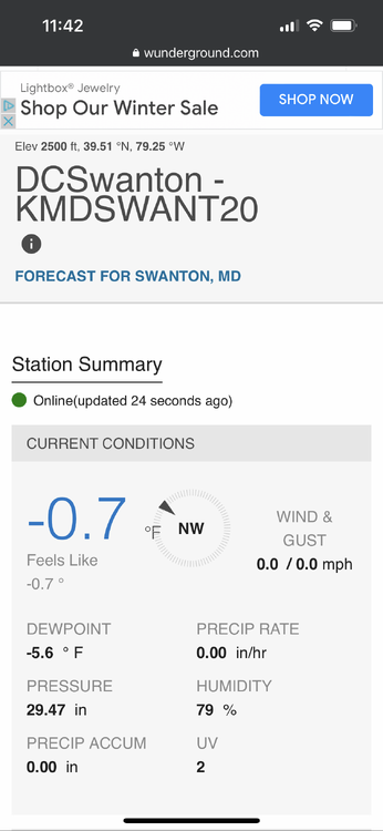
Blizzard conditions developing at Deep Creek. 26* and falling rapidly.
-
2
-
-
42 minutes ago, Ravens94 said:
Alot of ice up here by deep creek lake

It will be a bona fide glacier tomorrow. Lake should be rather solid by early week as well, big change from the holidays last year.
-
1
-
-
Forecast for Deep Creek shows temperature of 37* at 4AM tomorrow, descending to -6* by 12 or 1PM, and remaining largely steady until sometime Saturday morning.
-
3
-
-
Easily a fresh 2” in Swanton but the occasional pillow sized snowflakes suggest a warm layer somewhere close by. 26/25 on the temps, beautiful morning.
-
4
-
-
1 hour ago, nj2va said:
21/SN- 1.6” snow since last night

Feels like deep winter this morning
-
5
-
-
She's a soaker in Leesburg. 1.56" and backbuilding. 35*
Looks more white than wet in Swanton, probably all frozen from this point forward and going to stick around awhile. 30*
-
1
-
-
39/23 Leesburg
30/16 DCL Swanton
Hoping they keep power at the lake but not super optimstic. I turn the water off when I am not there but wasn't really prepared to have pipes freeze if the outage is extended.
-
14 minutes ago, nj2va said:
Yeah, increasingly becoming likely Cumberland west to deep creek see ice warning criteria met. Dews are in the teens out there at onset with temps during the storm in the mid to upper 20s. Only positive is precious looks to be moderate to heavy at times which should limit the accretion. But still a potentially high impact event out there followed by upslope snow showers Friday night/Saturday.
Please correct if wrong, but from a purely climo POV high impact all ZR events at DCL are more rare than locations where CAD is climatologically favored. Meaning, 9/10 times I see ZR in the zones for Garrett, it turns out to be PL/SN or nothing at all.
Noting these things seem to occur as a seasonal trend, and pointing out there was 24 hours of ZR / freezing fog at DCL just this past weekend (forecast verified), and it was anything but a high impact event there (WWA maybe didn't entirely verify). That said, it did get me wondering about all those depictions of mid level warm air being more than just a modeling anamoly vs. maybe a hint of a sesonal trend (hoping not).
-
2 hours ago, midatlanticweather said:
No, I was home from college in Richmond and we had a sleet/snow event Thanksgiving eve. I could have sworn it was 1990.
It was 1989 for sure
-
1
-
-
1 hour ago, WEATHER53 said:
Pretty big misread from NWS late last week as to this entire week. Too high on temps and I think we will see more misreads as we move along .
The low temps have been mild though. We just aren't seeing much in the way of range.
-
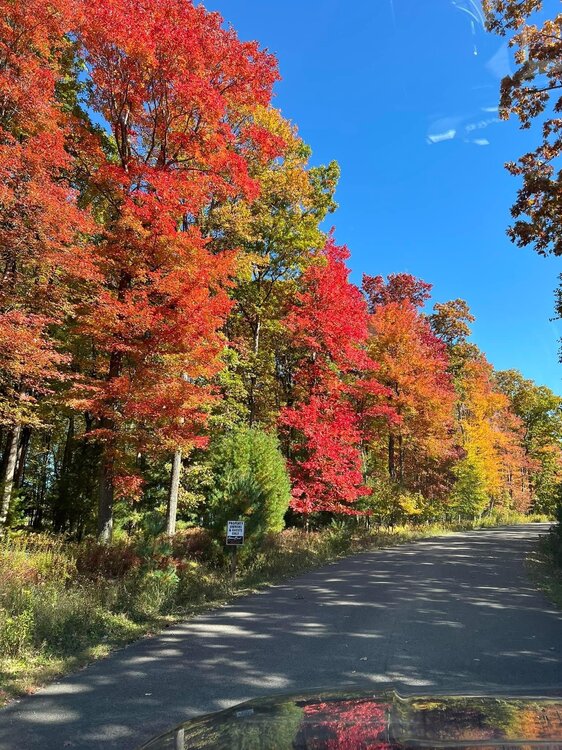
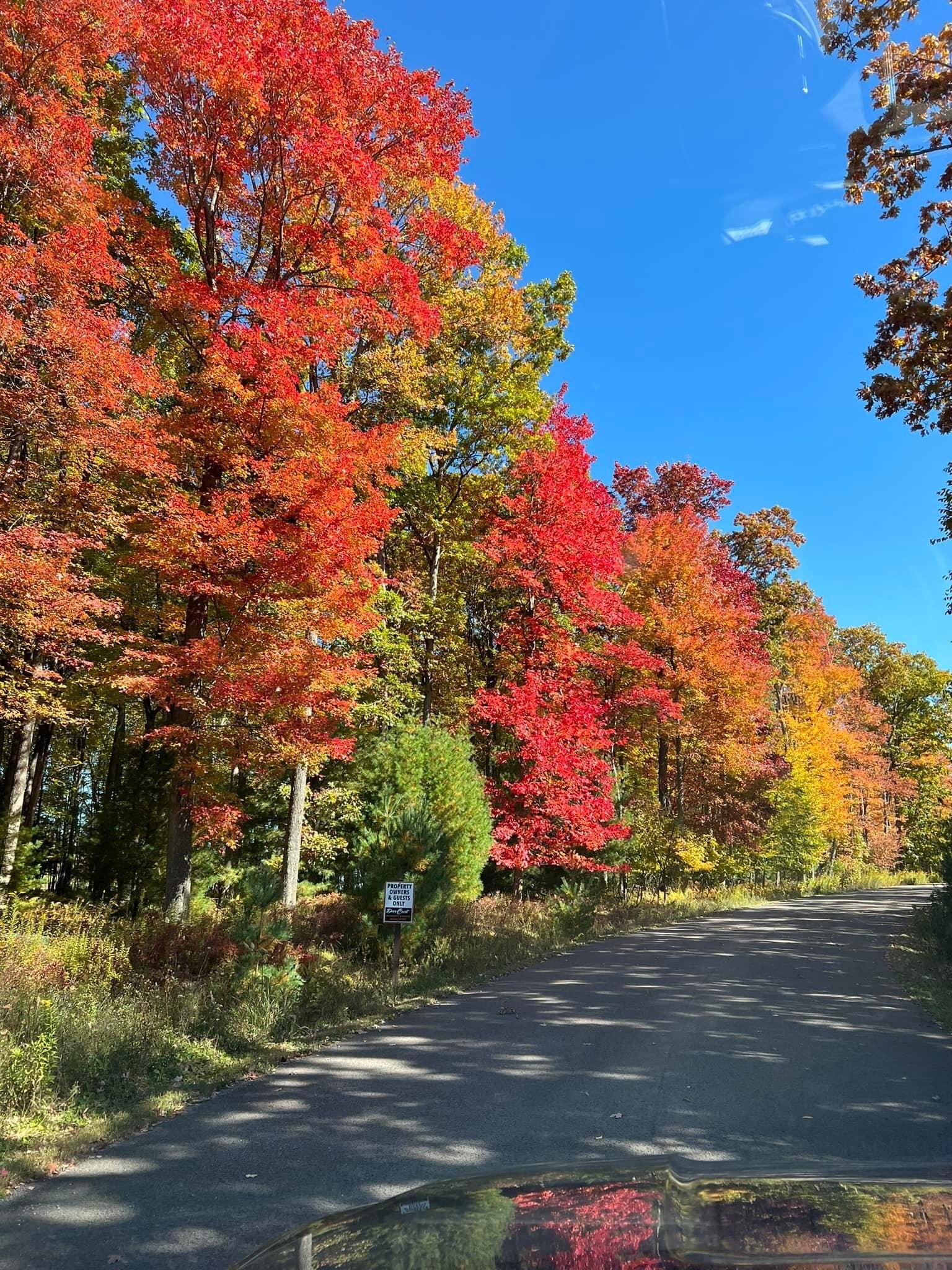
30.5 at Deep Creek ended up beating Saturday night and we had frost too. Full sun and back up to 54* now.
Colors at / near peak most everywhere
-
14
-
-
32 at Deep Creek. Wind picked up after midnight and the temperature spiked on 3 occasions to almost 36 and then settled back to 32 each time. Still a nice coating of frost. Crystal blue skies this morning 10/10.
-
1 hour ago, nj2va said:
37/34 at Deep Creek.
45/41 here in Moultonborough, NH.
34/32 now here. We are going to freeze good. Winds are decoupled and it otherwise feels like winter here.
Drove in this morning along new Germany road and savage river forest, if that area isn’t peak color it’s damn close. Color is pretty nice this year.
-
1
-
-
46* Deep Creek, 73* Leesburg. Looking forward to the excellent fall conditions this weekend.
-
1
-
 1
1
-
-
Freeze watch posted Garrett county
-
2 hours ago, nj2va said:
Leaves are changing here. Still mostly green but some color mixing in. Goldenrod is “past peak” for sure.
Last nights 38* and several more forecast in the 40's for the week to come will get things moving in a hurry I think. Either way, has me motivated to sweep my chimney and get ready for woodstove season in a few short weeks. Beautiful today but too chilly/windy to zoom outside.
-
1
-
-
Signed up for the IAD 10K run on Oct 1. Would prefer to have that SLP somewhere else. Fortunately we have another 38 chances for the solution to change.
-
On 9/14/2022 at 11:00 AM, nj2va said:
Yeah agree or the dreaded cutter that dumps 3" of rain then flips back to cold/snowy. Two winters ago, there was a stretch of Christmas week through late February (ish) of solid snow on the ground. They can handle periods where the pattern flips to unfavorable but it can't last for weeks on end like it did last December which forced Wisp to eventually close the week between Christmas and New Years.
Last year the holidays were warmer in absolute terms (50’s for days) than 2021 Memorial Day weekend at DCL (43*F the whole time) and that was a bona fide fact. No matter how many more years I got that is a feat I am betting won’t repeat.
I literally slept Memorial Day weekend next to a kerosene heater and Christmas it was too warm to burn the wood stove without raising the windows. I would really like to avoid that this year.
-
4
-
-
15 hours ago, mattie g said:
But just because a month is a degree above normal doesn't necessarily mean that the whole month will be above normal. Perhaps the first half of the month is slightly above normal, but the second is below. For December, that could absolutely work for us, and it wouldn't go that far against the general consensus forecasts at this time.
My POV is that a slightly AN February is far more likely to produce snow than a slightly BN December.
Nina climo here strongly suggests a cold/dry warm/wet coupling. It’s been pretty tough to get snow in December regardless the past decade or so. 2010 is maybe the best example I can remember that would work everything out and is a year some have mentioned but was not referenced in this particular outlook.


January/February Mid/Long Range Disco IV: A New Hope
in Mid Atlantic
Posted
I mean, I am on pace to burn 2 full cords of firewood and most days nobody is even there. Biggest problem is keeping it dry.
Last 12" snowfall for Deep Creek? last weekend of March 2022. Warm winters end cold and no reason to think '23 is ending any differently.