
RIC_WX
-
Posts
608 -
Joined
-
Last visited
Content Type
Profiles
Blogs
Forums
American Weather
Media Demo
Store
Gallery
Posts posted by RIC_WX
-
-
14.2 in Swanton just before 7AM. Crystal clear blue sky and frost everywhere.
-
 1
1
-
-
1 minute ago, Eskimo Joe said:
Starting to get that 2001 - 02 feel.
I was going to post this yesterday but somehow resisted it. Thank you.
As for GEFS, I get the feeling there is a classic thermal boundry setting up for the late holiday / post holiday period. On the right side of the boundry is cold/dry and on the wrong side you have today and the rest of this week. This pattern will eventually produce some cold days and nights, and pity snows (cartoppers). Chance of brine 90%.
There is legit cold air in western canada but without a mechanism to force it down, it's hard to envision a sustained period of deep winter.
IIRC the all time January high temp for several stations in VA was set in late January 2002 (~80*F).
-
26* Leesburg
17* Swanton (low of the season)
These numbers aren't being challenged anytime soon
-
1 hour ago, Amped said:

Merry Torchcember
Better the 14th than the 24th
-
72/52 Leesburg, cloudy
41/39 Swanton, light rain
-
Snowing off and on at Deep Creek since about sunset yesterday. Didn't really accumulate much before midnight, when winds picked up and temp dropped to 29*. Maybe 1" total so far but the frequent wind gusts to 30 MPH have really obliterated any chance for casual mesurement.
-
1
-
-
3 hours ago, nj2va said:
Home in Alexandria hosting a fall cocktail party this evening but it’s 29 at deep creek with a fresh coating of snow.
Light snow all morning accompanied by a flash freeze. Windy too. Finally cold enough to light my wood stove for it's inaugural burn.
-
3
-
-
On 11/8/2021 at 4:44 PM, nj2va said:
What are you thinking for the mountains? Last year I ended up just north of 110" so an average year. I'm thinking 60-90".
Between warm lakes and a predominant Miller B storm track, I see a lot of chances to score assuming we start and end cold. As long as January isn't a dreaded pac puke zonal flow (I see this pattern in several analogs), normal wx is plenty cold to still snow in the highlands.
I understand 19-20 was close to a generational low for Garrett and they still managed 50"-60". I would guess if this repeated itself it falls in the range of 50% of normal. Not impossible but have to believe we can do better.
I see snow pops in the zones for Saturday-Monday coming up. Looking forward to getting back up after 3 weeks of work travel.
-
1
-
-
48 minutes ago, psuhoffman said:
They never pay much attention to those local mountain zones. Always way under done.
Thing is, if they left the colors the same, removed the "inch" predictions and just said "between 50%-100% of seasonal normal" it would almost impossible not to verify. This is a safe prediction most years and especially so in a nina and even more so for the F5 viewing area.
Most of the population in the highlands isn't watching Fox 5 anyway
-
No one is really talking about how warm the great lakes are, basically everywhere, and when the pattern eventually does flip the LES potential could be epic.
-
1
-
-
27 minutes ago, nj2va said:
I still haven't had a freeze in Deep Creek. Lowest temp this fall has been 38 there.
Not even a frost at mine. Been checking the cameras past 2 mornings, nothing. Last year it was September 15.
-
1
-
-
19 hours ago, Cobalt said:
Even if similar, won't be close to the same. We throw around temperature comparisons without consideration of precipitation. The mid 2001-mid 2002 year was amongst the driest on record for the mid atlantic, precip maybe 50%-60% of normal. Nothing about the current era is remotely comparable to this. I think it fully disqualifies this analog, although most defnitely not suggesting it couldn't still turn out similarly mild.
-
2 hours ago, GramaxRefugee said:
Today's LWX AFD is mentioning these record numbers for Friday:
DCA - 87 in 1975
BWI - 86 in 1989
IAD - 88 in 1989
I think we don't get anywhere close to these, but wanted to note that October 1989 led to the coldest December ever recorded. Departure of -14.6 at IAD; -13.2 at BWI. Second coldest in Balto was in 1876, (departure -11.3). 12 of the December record min temps at IAD were set in 1989.It snowed on thanksgiving. 89-90 maybe the most front loaded winter of the past 50 years.
I can't entirely imagine a 2021 version of this to be nearly as interesting.
-
2
-
-
Some hints on LR GFS that at least the Potomac highlands could see first frost/freeze in the 25-26 time period. Hard to imagine getting out of October without this happening, but fairly certain most of the region has the growing season persisting even into the higher elevations.
It's getting pretty late in the season for this to not have happened at least once.
-
1
-
-
21 minutes ago, WxUSAF said:
FROPA still on track for D7-8. Doesn’t look cold behind it, but hopefully seasonable. Better than this crap and what we’ll have next week ahead of it.
Given that we are ~+7* or so for the month going into today, and this looks to maintain / build going into mid month, how does this compare with other weak-mod la nina Octobers?
The model is depicting potentially a near historically warm October and not just here. Outside of a couple cool downs to normal, pattern looks impressively (or depressingly) stable.
-
First hint of color showing up around Deep Creek, a few days earlier then I remember last year. I suppose a couple nights in the upper 40's last week and again this week are helping this along.

-
7
-
-
5 minutes ago, H2O said:
This weather sucks
IAD is only showing +1.6F for the month. Kind of a testament to how warm the new normals are I guess.
It's also easy to forget we were solidly negative for the first 7 days of the month (and +4.7 since 8.8). If the next 4-5 days were not predicted to be so hot the overall month would finish solidly...normal.
-
20 minutes ago, nj2va said:
Yeah, Deep Creek Lake looked noticeably lower than normal when we were at the house this past weekend. It's been dry there this summer.
Getting a wx station established ahead of winter is on my list of 1,000 unfinished projects. Something tells me I will get around to it by the time it really counts.
-
1
-
-
20 minutes ago, frd said:
Most of the real beneficial rains misses areas that really need it.
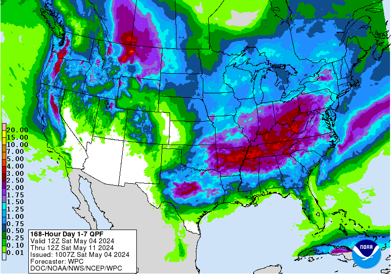
https://www.drought.gov/watersheds/mid-atlantic
Actually, if it falls as depicted over the mountains it is falling where it is needed the most (see link). Riverflows to the west of DC are pretty low, and the rain falling overtop of DC metro isn't going to change that.
-
High and dry at Deep Creek Lake

-
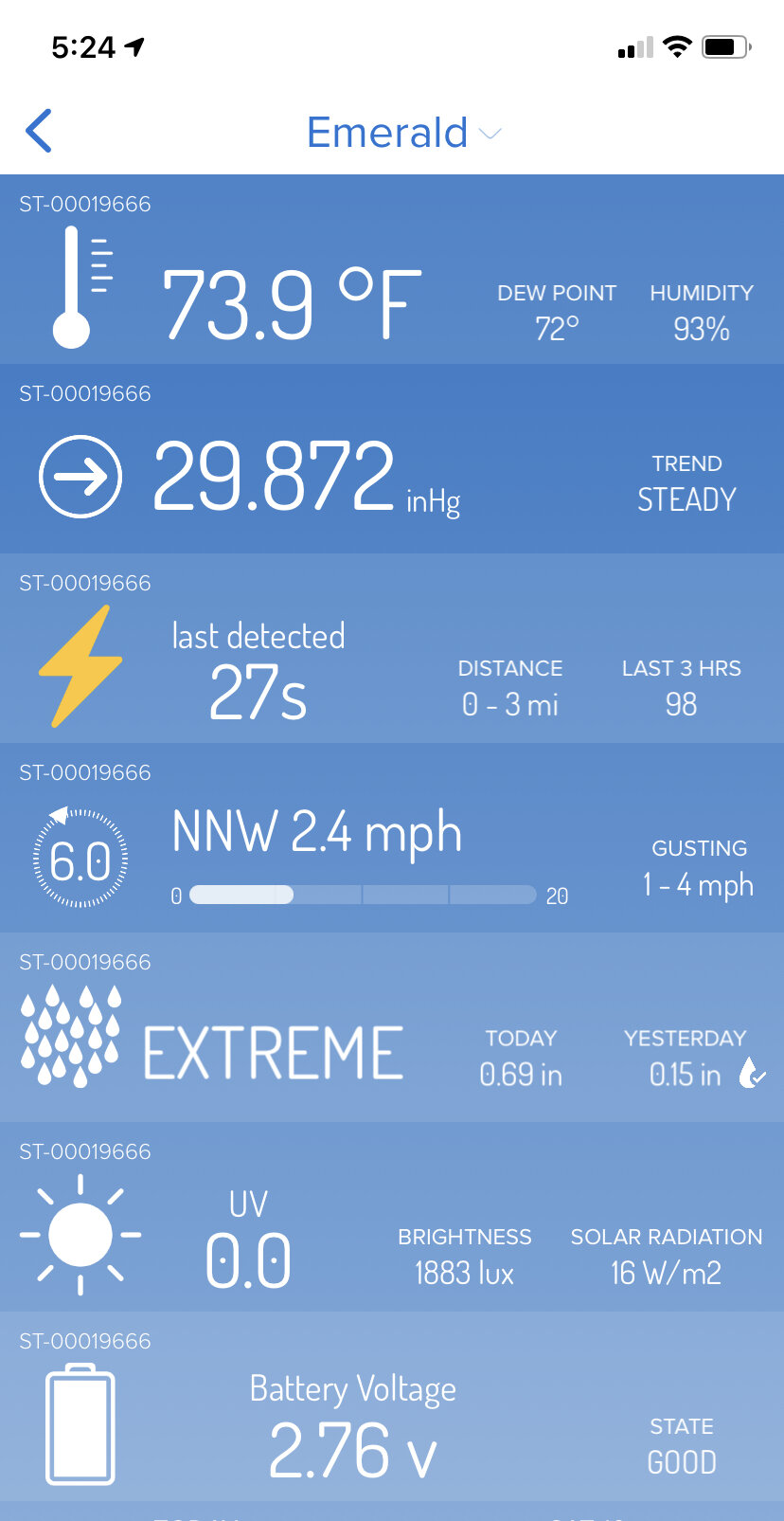
31 minutes ago, GATECH said:
I have never seen the ‘extreme’ rain rate on the weather flow tempest.

Can you review the weather flow tempest? Reading reviews online that the haptic rain sensor overestimates and then smooths out after the fact to try and correct itself. True?
-
36 minutes ago, RIC_WX said:
Quite the storm parked over east side of Leesburg, several episodes of hail and closing in on 1" with no sign of slowing down anytime soon.
71/71
Wrapping up now, 2.1" and tree down at home across street.
-
Quite the storm parked over east side of Leesburg, several episodes of hail and closing in on 1" with no sign of slowing down anytime soon.
71/71
-
The line of storms rolling through Deep Creek is legit. Let's see if they hold together crossing these hills.


January Medium/Long Range Discussion
in Mid Atlantic
Posted
I agree we all want to look smart and accurately predict the seasonal pattern progression with some scientific basis of thought. I think some of the frustration / cynycisim however stems from all of the pre season prognostication, where one would expect it is easier to get the first month of the season right rather than the later months. I don't recall many predicting on the record that December was going to more or less torch wire to wire - most of the predictions were for a "front loaded winter". If the consensus forecast gets the first month completely wrong, it's hard to say we scientifically had any more than equal chances in speculating where we might end up.
Last week the ensembles showed normal to below temperatures beginning on or about 12.28. Now next week looks normal to above on the ensembles, and teasing the more significant pattern change in early January. This isn't deb, it's just a disappointing reality for anyone anticipating avoiding a torch for the holidays. There appears to be the potential for a lot of mild weather and a handful of only seasonably chilly days.
Eventually what appears to be an incredibly stable (but hostile for us) pattern in the pacific is going to break down. Whomever can explain, time and predict this with accuracy deserves the accolades.
I am pretty skeptical this happens in early January, at least on a sustained basis. Happy to be called wrong if it does.