

yoda
-
Posts
59,574 -
Joined
Content Type
Profiles
Blogs
Forums
American Weather
Media Demo
Store
Gallery
Posts posted by yoda
-
-
Thursday sounds interesting... from this mornings AFD
.LONG TERM /THURSDAY THROUGH SUNDAY/...
To the south of a deep upper trough tracking across Quebec will
be a series of lower amplitude waves that race toward the Mid-
Atlantic region on Thursday. As this occurs, a slow moving cold
front is expected to push through the local area by midday into
the evening hours. There is fairly strong mid/upper support with
a belt of 500-mb west-southwesterlies around 40 to 50 knots.
This is accompanied by ample right entrance region jet dynamics
within a jet streak running between 100 to 110 knots. The key
parameter that will dictate the degree of severe weather threat
is the instability. At this point, even global ensembles are
showing around 1,000 to 1,500 J/kg of surface-based CAPE on
Thursday. This would be more than adequate to support severe
convection given the extent of vertical shear in the profile.
However, as usual, the near to short term trends of cloud cover
which inhibits convective potential will need to be monitored
ahead of the event. Besides the threat for showers and
strong/severe thunderstorms, it should be a very warm day with
decent humidity owing to persistent south-southwesterlies.
Forecast highs are in the mid/upper 80s, with heat indices
approaching the low 90s. The frontal boundary eventually slides
off to the south by Friday morning.
-
 4
4
-
-
What's going on in Cecil county? Never seen this before from LWX
BULLETIN - EAS ACTIVATION REQUESTED
Law Enforcement Warning
MD Cecil County Department of Emergency Services
Relayed by National Weather Service Baltimore MD/Washington DC
622 AM EDT Mon May 20 2024

...Law Enforcement Warning...

The following message is transmitted at the request of CCSO.

Police activity in the area. Please stay indoors. There is
currently no threat to the public.

$$

OnSolve-e9a5f08051364d648cad1bae12903c97/MD Cecil County
Department of Emergency Services
-
LWX hinting at chance of severe next week in their afternoon AFD
LONG TERM /TUESDAY THROUGH SATURDAY/...
A broad upper level ridge is forecast to be remain in place over the
eastern seaboard on Tuesday with high pressure at the surface. A
southerly return flow will lead to increasingly warming
temperatures through the middle parts of next week. The SFC high
pressure on Tuesday will keep the region dry, but an approaching
cold front from the west will bring increasing chances for showers
and thunderstorms Wednesday through Friday. Model guidance has
trended slower with the mid-week system and there remains some
uncertainty if there will be enough instability (CAPE) that overlaps
with the favorable period for shear to produce a threat for severe
weather. SPC is focusing on the Ohio Valley for SVR weather
Wednesday into Thursday, but the CIPS machine learning model
continues to suggest that there is a chance for isolated severe
weather in our region during the middle and later parts of next
week.
-
Been pouring the past hour here
-
9 hours ago, Jrlg1181 said:
Yeah and my expectations of a another dud is looking more like the usual reality... Will see later 2nght if any legit rain occurs...
Looks like its raining down there
-
-
-
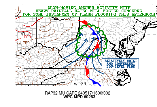
https://www.wpc.ncep.noaa.gov/metwatch/metwatch_mpd_multi.php?md=0283&yr=2024
Mesoscale Precipitation Discussion 0283
NWS Weather Prediction Center College Park MD
135 PM EDT Fri May 17 2024

Areas affected...Portions of the Central Appalachians/Blue Ridge

Concerning...Heavy rainfall...Flash flooding possible

Valid 171735Z - 172335Z

SUMMARY...Slow-moving shower activity with heavy rainfall rates
will tend to increase in coverage this afternoon across areas of
the central Appalachians including parts of the Blue Ridge. This
coupled with moist antecedent conditions will promote a threat for
some instances of flash flooding.

DISCUSSION...A broad mid to upper-level trough over the OH Valley
will continue to move gradually off to the northeast today toward
the central Appalachians. Some generally weak DPVA/forcing
associated with this will be interacting with modest
diurnally-enhanced instability and a relatively moist airmass for
broken areas of heavy showers.

Radar imagery already shows some locally heavy shower activity
impacting areas of southeast OH into southwest PA and down through
central WV as the leading edge of relatively stronger forcing
aloft arrives. Some expansion of this activity with a general
increase in rainfall rates can be expected this afternoon as
MUCAPE values increase to locally over 1000 J/kg and couple with
smaller scale areas of more targeted moisture convergence in
vicinity of a quasi-stationary front draped over the higher
terrain.

Relatively moist southeast flow will also provide a localized
orographic component to the rainfall threat with southeast-facing
slopes of the central Appalachians and portions of the Blue Ridge
seeing pockets of more focused low-level forcing for slow-moving,
but heavy shower activity.

The rainfall rates should be efficiently high given the overall
depth of moisture through the vertical column which was evidenced
in 12Z RAOB data across the broader OH Valley this morning in
connection to the aforementioned trough. The modest increase in
instability will favor some shower activity capable of producing
rainfall rates of 1 to 1.5 inches/hour with the stronger cells.

Given the overall weak steering flow, and orographic nature of
some of the convection, there may be a sufficient level of
persistence to the showers to yield some excessive totals. This is
being supported by the 12Z HREF guidance which suggests some of
the heavier rates focusing over parts of southwest PA through the
eastern WV/MD panhandles and northwest VA in vicinity of the Blue
Ridge. Some spotty 2 to 3+ inch rainfall totals will be possible
by early this evening, and with moist antecedent conditions/lower
FFG values in place, some instances of flash flooding will be
possible.

Orrison

ATTN...WFO...CTP...LWX...PBZ...RLX...RNK...
-
5 minutes ago, TSG said:
I cursed us. I'm sorry.

-
Meanwhile in Houston
 33 minutes ago, WxWatcher007 said:
Grid demolished. Over a million outages statewide and 40% of Harris County without power.
-
Needed rain
Heading into Saturday, a stronger shortwave moves into the
southeast to pick up the stalled warm frontal boundary.
Continued shower and thunderstorm activity is expected through
day Saturday. Isolated flooding continues to be a concern with
repeated rounds of slow moving showers. Around 1-2 inches of
rain are expected through the duration of the weekend. Some
areas could see closer to 2.5 inches, but confidence on exactly
where is low as it depends on where the boundary will be Friday
night into Saturday. For now, highest estimates are in portions
of the Shenandoah Valley and Virginia Piedmont. Shower and
thunderstorm coverage decreases through Saturday evening as the
low moves off to the southeast, but rain likely continues into
Sunday.
-
LWX mentions Wednesday as next chance for some severe storms in the afternoon AFD
Fairly potent system approaches the area by Wednesday, with a cold
front advanced out ahead of the system. Guidance has been hinting at
the opportunity for increased instability ahead of the frontal
passage. Could see some thunderstorms develop, with some getting
strong to severe. Still a lot of uncertainty with this system with
respect to timing and intensity. Highs on Wednesday will be in the
upper 70s to low 80s.
-
14 hours ago, Eskimo Joe said:
NWS Sterling confirms 2 tornadoes from Saturday: https://www.weather.gov/lwx/GarrettTorsMay2024
2 EF1s... pretty decent for around here
-
1
-
-
It's been 28 years since Twister came to theaters? Wow
-
1
-
 1
1
-
-
Do northern stream s/w's bring about our better severe weather threats? There was an interesting tidbit at the end of this mornings AFD
Upper level ridging tries to build back into the area Sunday into
Monday bringing slightly drier conditions. Another front will follow
with renewed chances for showers and thunderstorms Tuesday and
Wednesday next week. Temperatures will continue to warm back above
average during this time leading to the potential for greater
instability for thunderstorm activity to feed off of. With a fairly
active northern stream will continue to monitor for any severe
weather or hydro threats within the extended period. Right now,
there is no mention in the Day 4-8 outlook from the Storm Prediction
Center.
-
1 hour ago, WxUSAF said:
I’m running a school event that has been planned for a year. It can be mostly indoors but that will really cramp fundraising. We have 4 food trucks…
27 minutes ago, Paleocene said:Ugh. We have similar deal Saturday - community event that has been planned since the fall. Need it to be dry
-
4
-
-
31 minutes ago, Kmlwx said:
Wow - radar is actually a good old fashioned squall line - subsevere it seems mostly but it reminds me of the 90s/2000s squall lines that were solid/contiguous. HRRR looks good for DC Metro and Maryland
looks to be intensifying slightly?
-
56 minutes ago, Kmlwx said:
There's a distinct "buckle" in that line up there. Plus, it's possible the higher terrain is not giving the radar the clearest view. Probably a more CYA warning than anything - but wouldn't be surprised if there's wind damage with it.
Preliminary Local Storm Report National Weather Service Baltimore MD/Washington DC 1021 PM EDT Sat May 11 2024 ..TIME... ...EVENT... ...CITY LOCATION... ...LAT.LON... ..DATE... ....MAG.... ..COUNTY LOCATION..ST.. ...SOURCE.... ..REMARKS.. 0930 PM Tstm Wnd Dmg Berryville 39.62N 78.23W 05/11/2024 Morgan WV 911 Call Center Several trees and wires blew down causing a couple of transformer fires in the 100 block of Rockwell Street. && Event Number LWX2403121 -
2 minutes ago, EastCoast NPZ said:
Good storm in progress. By far, best of the year.
Sure it's not a mirage?
")
-
1
-
-
BULLETIN - IMMEDIATE BROADCAST REQUESTED Severe Thunderstorm Warning National Weather Service Baltimore MD/Washington DC 942 PM EDT Sat May 11 2024 The National Weather Service in Sterling Virginia has issued a * Severe Thunderstorm Warning for... Washington County in north central Maryland... Northeastern Jefferson County in the Panhandle of West Virginia... Northeastern Morgan County in the Panhandle of West Virginia... Berkeley County in the Panhandle of West Virginia... * Until 1015 PM EDT. * At 942 PM EDT, severe thunderstorms were located along a line extending from 6 miles east of Hancock to 8 miles southeast of Berkeley Springs, moving southeast at 35 mph. HAZARD...60 mph wind gusts. SOURCE...Radar indicated. IMPACT...Damaging winds will cause some trees and large branches to fall. This could injure those outdoors, as well as damage homes and vehicles. Roadways may become blocked by downed trees. Localized power outages are possible. Unsecured light objects may become projectiles. * Locations impacted include... Hagerstown, Martinsburg, Charles Town, Shepherdstown, Municipal Stadium, Robinwood, Fountainhead-Orchard Hills, Ranson, Boonsboro, Smithsburg, Paramount-Long Meadow, Wilson-Conococheague, Williamsport, Mount Aetna, Mount Lena, San Mar, Harpers Ferry, Long Meadow, Kearneysville, and Saint James. PRECAUTIONARY/PREPAREDNESS ACTIONS... Remain alert for a possible tornado! Tornadoes can develop quickly from severe thunderstorms. If you spot a tornado go at once into the basement or small central room in a sturdy structure. For your protection move to an interior room on the lowest floor of a building. && LAT...LON 3967 7754 3953 7761 3932 7770 3931 7774 3925 7777 3949 7819 3972 7810 3972 7769 TIME...MOT...LOC 0142Z 294DEG 30KT 3970 7805 3953 7813 TORNADO...POSSIBLE HAIL THREAT...RADAR INDICATED MAX HAIL SIZE...<.75 IN WIND THREAT...RADAR INDICATED MAX WIND GUST...60 MPH -
SLGT risk still for areas east of the i81 corridor up to the Mason-Dixon line on the new day 1... 2/5/15
-
Updated HWO from just before 2pm still hitting hard for tomorrow
DAYS TWO THROUGH SEVEN...Thursday through Tuesday

Scattered severe thunderstorms capable of producing damaging wind
gusts and large hail are likely Thursday afternoon. There is the
potential for considerable wind damage from 70 mph gusts and large
hail.

Special Marine Warnings may be needed for portions of the waters
Thursday for strong to severe storms capable of producing wind
gusts over 34 knots and large hail.

Heavy rainfall Thursday could result in isolated instances of
flooding.
-
Right near KIAD

-
06z NAM NEST is flagging PDS TOR soundings with the supercells it develops Thursday evening in N MD lol
-
1
-
2024 Severe Weather General Discussion
in Mid Atlantic
Posted
LWX mentions very isolated threat tomorrow, chance on Thursday, and then possibly substantial on Monday in the morning AFD