blizzardmeiser
-
Posts
721 -
Joined
-
Last visited
Content Type
Profiles
Blogs
Forums
American Weather
Media Demo
Store
Gallery
Everything posted by blizzardmeiser
-
We had a lot of great days last August. Enjoy these few days, it is better than 37 and rain
-
JB referencing March 1993!
-
Amazing out. Top 10 weather day.
-
Finally made it to the mid 50s. Hoping to get into the 60s today with some sun.
-
52 and dreary. Looking forward to next week
-
Outta gas and Outta Time: Early March Winter Storm finale
blizzardmeiser replied to Ji's topic in Mid Atlantic
Yup, white rain. -
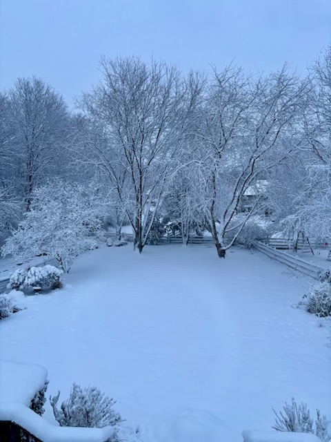
Just beautiful out there. This is long overdue.
-
Great summary. I agree the forecast was spot on and a 75 mile difference is minimal given the window. Thanks for sharing.
-
Late February/Early March 2026 Mid-Long Range
blizzardmeiser replied to WxUSAF's topic in Mid Atlantic
another daffodil destroyer and crocus crusher? One of these years he will be right. -
Late February/Early March 2026 Mid-Long Range
blizzardmeiser replied to WxUSAF's topic in Mid Atlantic
What are JB's thoughts? He nailed the last storm! -
Feb 22nd/23rd "There's no way..." Obs Thread
blizzardmeiser replied to Maestrobjwa's topic in Mid Atlantic
Northern DE still got 8.5 inches. I believe he said NO Storm! -
Feb 22nd/23rd "There's no way..." Obs Thread
blizzardmeiser replied to Maestrobjwa's topic in Mid Atlantic
7.5 but already has melted a few inches. Very wet snow. -
Feb 22nd/23rd "There's no way..." Obs Thread
blizzardmeiser replied to Maestrobjwa's topic in Mid Atlantic
-
Feb 22nd/23rd "There's no way..." Obs Thread
blizzardmeiser replied to Maestrobjwa's topic in Mid Atlantic
Still snowing but lighter now. 7.5 so far. -
Feb 22nd/23rd "There's no way..." Obs Thread
blizzardmeiser replied to Maestrobjwa's topic in Mid Atlantic
5.7 with heavy snow. -
Feb 22nd/23rd "There's no way..." Obs Thread
blizzardmeiser replied to Maestrobjwa's topic in Mid Atlantic
URGENT - WINTER WEATHER MESSAGE National Weather Service Mount Holly NJ 941 PM EST Sun Feb 22 2026 ...A MAJOR WINTER STORM WILL CONTINUE TO IMPACT THE REGION THROUGH MONDAY... .A major winter storm will continue to impact the region through Monday. Very heavy snowfall and areas of blizzard conditions are expected. Moderate to heavy snowfall with rates of 1 to 2 inches per hour or more will persist overnight and into Monday morning. The heavy, wet snow will stick to trees and power lines, resulting in scattered tree damage and power outages. Record breaking snowfall totals are possible. DEZ001-002-MDZ015-019-020-231500- /O.CON.KPHI.BZ.W.0001.000000T0000Z-260223T2300Z/ New Castle-Kent-Queen Annes-Talbot-Caroline- Including the cities of Dover, Centreville, Wilmington, Easton, and Denton 941 PM EST Sun Feb 22 2026 ...BLIZZARD WARNING REMAINS IN EFFECT UNTIL 6 PM EST MONDAY... * WHAT...Blizzard conditions. Additional snow accumulations between 8 and 12 inches. Winds gusting as high as 45 mph. * WHERE...In Delaware, Kent and New Castle Counties. In Maryland, Caroline, Queen Annes, and Talbot Counties. -
Feb 22nd/23rd "There's no way..." Obs Thread
blizzardmeiser replied to Maestrobjwa's topic in Mid Atlantic
4.25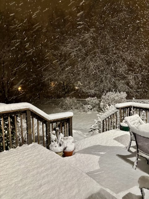
-
Feb 22nd/23rd "There's no way..." Obs Thread
blizzardmeiser replied to Maestrobjwa's topic in Mid Atlantic
Flipped to all snow now. -
Feb 22nd/23rd "There's no way..." Obs Thread
blizzardmeiser replied to Maestrobjwa's topic in Mid Atlantic
Folks panicking and cutting snow totals based on latest trends. -
It’s embarrassing that the gold medal is going to be decided on three on three hockey
-
2/22-23 "There's no way..." Storm Part 2
blizzardmeiser replied to Maestrobjwa's topic in Mid Atlantic
Temps will be a problem until the evening -
2/22-23 "There's no way..." Storm Part 2
blizzardmeiser replied to Maestrobjwa's topic in Mid Atlantic
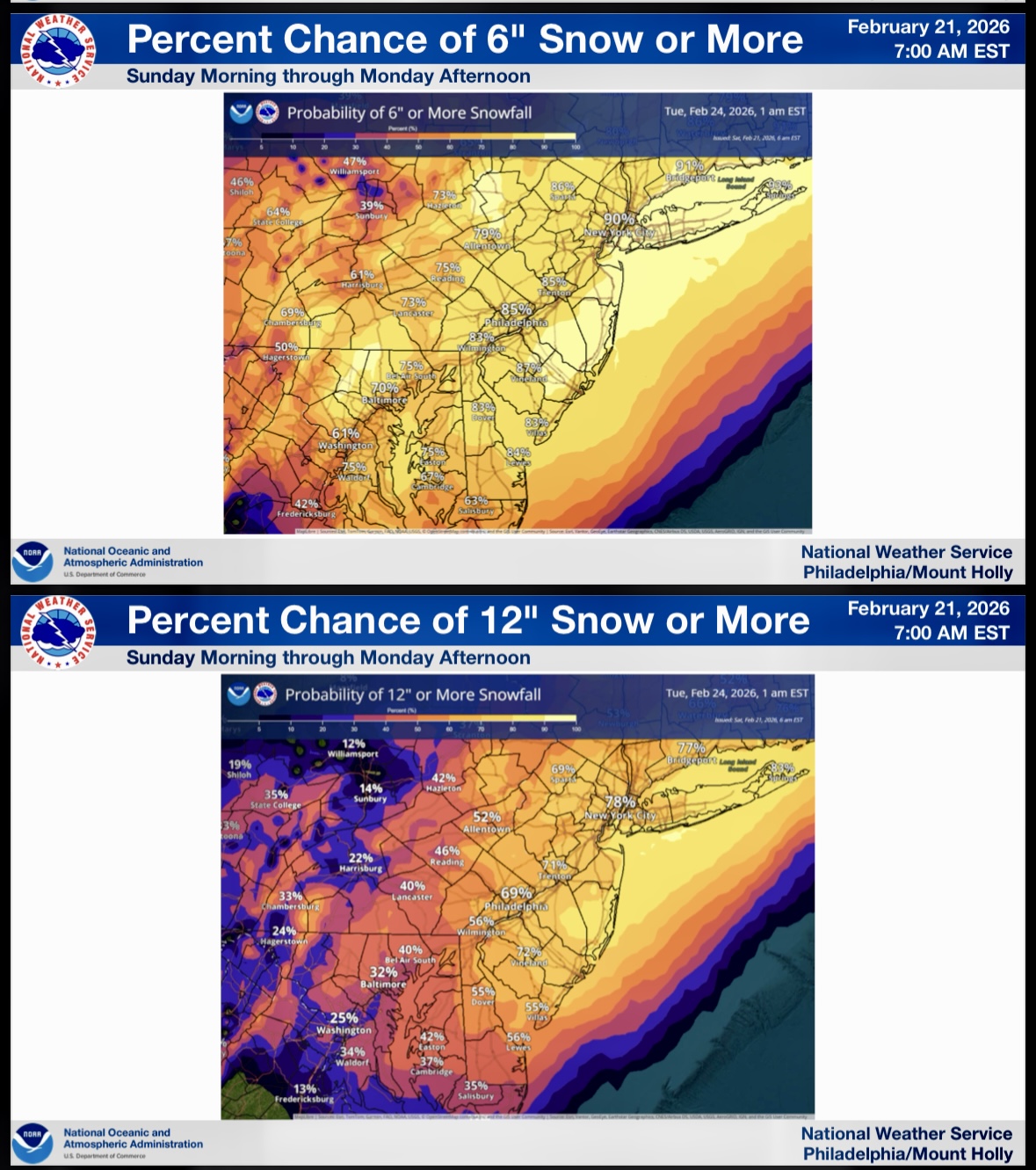
Mt Holly very bullish, Balt east 70%+ of 6 or more
-
Feb 22nd/23rd "There's no way..." Storm Thread
blizzardmeiser replied to Maestrobjwa's topic in Mid Atlantic
He uses the Mark Model -
Feb 22nd/23rd "There's no way..." Storm Thread
blizzardmeiser replied to Maestrobjwa's topic in Mid Atlantic
The JB storm -
Feb 22nd/23rd "There's no way..." Storm Thread
blizzardmeiser replied to Maestrobjwa's topic in Mid Atlantic
I’m hearing references on social media referring to it as the blizzard of 26!