

WeatherNC
-
Posts
3,564 -
Joined
Content Type
Profiles
Blogs
Forums
American Weather
Media Demo
Store
Gallery
Posts posted by WeatherNC
-
-
2 hours ago, Queencitywx said:
did Wilkes get banned and come back again?
I canned what was the latest iteration earlier this week, Red1976Red. Unless he is now spoofing a TWC residential connection in Raleigh which I guess is possible, I doubt it is him. Wilkes had an affinity for MS Paint, this guy seems a bit more professional plus he has an in house model. Nodules is a physiology term, he lost some credibility there. Ted's part about boundary layer issues in Orlando and that random dog on chicken .gif were pretty funny.
-
 3
3
-
-
14 minutes ago, Red1976Red said:
RDPS your on the list now. and just so u know i write these things down and dont forget for years!
Neither do I
")
-
1
-
 3
3
-
-
16 minutes ago, frazdaddy said:
Any word on why or what happend?
@WRISKCOM ?
-
2
-
-
20 minutes ago, Red1976Red said:
Soaking in a lavender scented salt bath right now watching everything trend east. Perfect.
Anything to get the stench out of the local Wilkesboro Utilities supply man.
-
5 minutes ago, frazdaddy said:
I miss his ms paint call maps.
He's around, I haven't lost the scent.
-
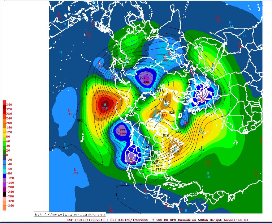
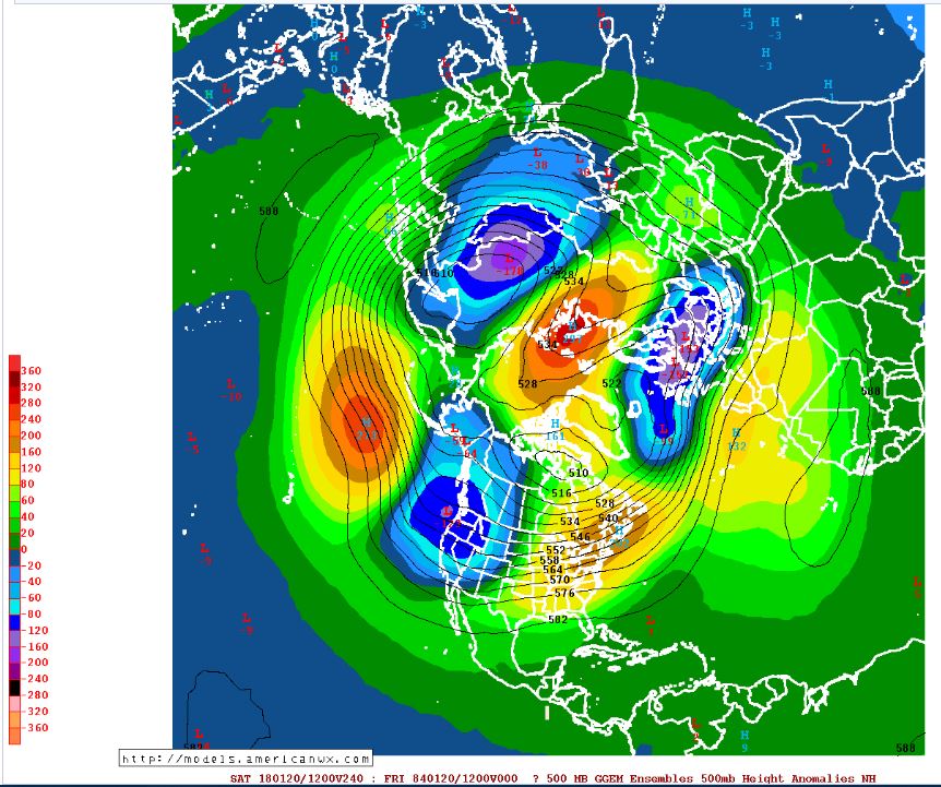
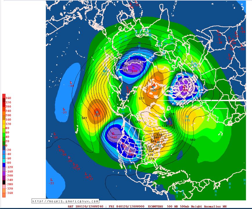
Since we are punting for the next ~3 weeks, a look at the big 3 12z ens means at H5. Unsure if this is still cool or we are holding out for metaphysical accumulations in the upstate this weekend.
PAC looks like ass, AO should hold slightly neg, NAO around neutral, MJO (http://www.americanwx.com/raleighwx/MJO/MJO.html) would argue temps avg close to normal throughout the period, with a above normal period thereafter, any real potential being close to Feb 1st and beyond. I would keep an eye on the 23-24th, doubt the setup is there for the deep south but the MA and NE could cash in if we do in fact get a storm.
-
2
-
-
I am receiving .ru popups when navigating and not logged in on Safari iOS. Just logged in and no issues thus far. Desktop, Windows 10 is fine either way.
-
14 minutes ago, shahroz98 said:
Do you think this'll be a trend ?
If the Euro follows suit then yes, still a little too early to tell but navigating this tight rope is similar to the 1st week of March.
-
1
-
-
About to take off the mower deck and rebuild it, leave it to Honda to over-engineer the darn thing. Bearings have to pressed on to the shafts, if it weren't for the rebuild of the troybilt horse back end a few years ago I would feel out of my league.
A couple of the sycamores a died back last year and are not looking so hot, wondering if I need to take them out while young and replant with chestnut oak or white oak. Anthranocosos is a big killer here of sycamores, I have 5 in a row and wondering if 2 got hit.
-
20 minutes ago, mackerel_sky said:
Oh sh!t! Nam extrapolation! That's what this winter has become!!? Where's the DGEX maps!?

They're out there they just don't show snow
-
I am taking up wood working this year, seemed like a good fit since I have a lot of screws on hand.
-
It's been over 14 years since Raleigh had an official 8" plus storm, 2002 I think.
-
Like a kid on Christmas morning, being in a good snowstorm is my comfort zone.
-
Now that it is snowing outside I feel better.
-
I drove to Roanoke Rapids for a couple inches of crust, words cannot describe the level of disappointment.
-
Whatever happened to Jim? One would think a weather conglomerate like TWC would do a better job putting these guys in the thick of it.
-
OK, I am panicking, flipped to sleet and that line is booking north. Should have listed to Fraz and hit up the 85 corridor. Sleet is nothing more than a winter weather sideshow.
-
21 minutes ago, magpiemaniac said:
Stupid how TWC sends to road reporters to Raleigh and Charlotte just to witness wet slush.
I found WRALs Drive 5 zipping through the dusted streets of Durham much more entertaining.
-
CR's dangling that NAM carrot.
-
About to be sails up to Roanoke Rapids, just north of the city. It was between there, Warrenton and even kicked around the 85 corridor but coming back tomorrow afternoon should be easier. Banking on the GFS and Euro with the RGEM's IP fringe job being fatties.
-
Thinking maybe Henderson now, don't have a warm and fuzzy about Roanoke Rapids
-
Just hit our forecasted high of 45
-
Louisburg of Roanoke Rapids? Going to leave tonight as is will be ripping in the early AM. Going to attempt to get to Medoc Mountian tomorrow for some outdoor activities.
-
PGV's tapped out, expecting no less than 9hrs of pingers.
Mid to Long Term Discussion 2018
in Southeastern States
Posted
Means are a better tool outside of 168hrs, just saying... Wholesale cold is coming back, length of day would argue it is not as intense as recent but we have 3-4 weeks of potential incoming. Most would say thus far their above avg winter was bounded by a 2-3 week period.