

WeatherNC
-
Posts
3,564 -
Joined
Content Type
Profiles
Blogs
Forums
American Weather
Media Demo
Store
Gallery
Posts posted by WeatherNC
-
-
20 minutes ago, HKY_WX said:
Not familiar with the ILM area, but how would it cope with 40 inches of rain lol? Looking at this thing starting to stall out (already), I'm starting to think some of these estimates may be right.
It won't be good, Lumber and Cape Fear basins, based on RAH's historical graphics, Floyd + Dennis type total plus 10" in a single event.
-
6 minutes ago, Cold Rain said:
If this was a snowstorm in January, it would be north, north, north every run.
Any way you cut it, there's going to be a local min over SE Wake county.
-
 1
1
-
 2
2
-
-
While recon shows the center fixes bending left, my educated guess is the half-a-eyewall is bouncing around a broader maxima based on microwave and will likely continue to wobble wnw-nw until late this evening. It does appear though the slow down has begun per satellite.

-
Based on microwave, structure is taking its final shape before direct impacts are felt along the coast. Another ERC is pretty clear at this point unless I am missing something.
-
1
-
-
1 minute ago, downeastnc said:
Hey post me up a link to those TAB outputs.....
Still waiting for Albany to update but based on SFWMD 0z are now well off the SC coast.
-
Just now, SouthWake33 said:
Thanks for your insight. Can you please clarify what you mean by RAH/MHX would be your message?
National Weather Service Office in Raleigh and Morehead City.
-
Real deal Floyd Irene sandwich if this lines up, we are well inside the cone. If I was in a position to inform the general public RAH/MHX would be my message based on the data I have access to, as opposed to subjective views from WRAL or WITN.
-
1
-
-
6 minutes ago, KPITSnow said:
Can someone explain why sitting off the coast by 100 miles means it weakens?
I remember Harvey last year absolutely crawling onto the coast and bombing out while it was just off shore?
Upwelling, dry air entrainment from nearby land, increased sheer, there’s several mechanisms at play.
-
10 minutes ago, Cold Rain said:
This is just anecdotal, but I have seen a lot more 3-4 day model forecasts for stalls (leading to major flooding and disaster) than I have actually seen stalls happen. Really doesn’t tell us much about this situation...just an observation.
GEFS would indicate a stall. I agree, it should not happen, same as us not feeling direct impacts from a storm given the current position. We are just clearing Bermuda to the south, still need to be real at this early stage.
-
The odds of steering currents breaking down is real, it’s just a matter of where at this point, it could be western NC, central VA or offshore (still very much on the table, climo supports). The Euro gives pause but the trend over the past 24 hours is east, no doubt.
-
4
-
-
6 hours ago, Akeem the African Dream said:
give me 110kt at landfall
id gamble and ride it out if I was on the coast as well.
All depends on where you are at with respect to the right front, I studied that area north off ILM through Lookout, Topsail in particular, one of the most active sandbars on the east coast, I would be inland.
-
 1
1
-
-
I am likely in the market for a generator tomorrow too. Point of clarification on the above post and based on local media, Carteret is just maditory on the barrier islands starting in the AM. Tomorrow is the action day for the coast, Wednesday would be for prone interior. Indland counties will likely put out voluntaries as Beaufort is already doing
-
Position error at this range is still 100-150 miles, that’s absolute position as opposed to east - west, everywhere from MYR to HAT and even offshore is still within the track error. Still a ways to go and ala Irma, Florence has by no means drawn her final card.
-
2
-
-
7 minutes ago, downeastnc said:
Depends on track for us the current NHC track is bad enough we would be 30-40 miles from center on the N and E side not where you wanna be, any more shift to the east and we will be NE eyewall....really really don't wanna be there........could get some seriously high gust if that played out, look at what Irene did with 60-70's imagine 90-120 mph.
Op Euro and GFS blend would be pretty close to a worst case scenario, I do like the FV3, which is pretty lock step with the Euro. At this stage I would toss the ensembles within reason, still a tool but not something I would weight a landfall forecast on. The TAB is a great tool and as long as it shows those steering currents break down ivo landfall, the comfidence it will slow down greatly is high, along with any late stage change in course.
-
1
-
-
I’ll be honest, at this point I am more stressed and concerned than excited. Don’t get me wrong, I like a good sustained wind about as much as anyone, just as long as it’s not on my house. The real worry and I think at this point my house is ok, is the potential stall and biblical amounts of rain. That’s a worst case scenario for emergency management, two disasters to deal with as opposed to one. It would take 3-7 days for rain to empty into the sound, its not a fast process by any stretch and will greatly hamper reocervey efforts from the immediate storm.
-
1
-
-
12z UK came north, landfall around the NC/SC border. Two camps at this point, foreign vs domestic.
-
1
-
-
55 officially in Greenville
-
55 @PGV this AM but not really a mid - long range topic, sure fealt nice though.
-
Sh!t just got real when HM showed up in the MA.
-
1
-
-
40 minutes ago, WarmNose said:
Boom goes the dynamite
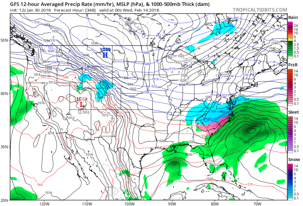
Please stop posting 300+ hour op maps in the disco thread, these are nothing more than banter.
-
2
-
1
-
 1
1
-
-
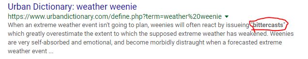
2 minutes ago, mackerel_sky said:
No, I'll never forget 2014 Feb storm. Euro snow map showed me getting 20" 2 days out, got 2" of sleet, it was awesome
Likely a stock 10:1 snow flag, no more than weenie click bait, you over-performed.
-
1 hour ago, mackerel_sky said:
We have about as much of a chance at getting a snowy last half of Feb, as the Tarheels have of beating State!

-
1
-
1
-
6
-
-
The AO (not NAO, look at your N Hemi Ens maps) in the 7-14 range should be a good representation of do we keep the PV in Central CA, or does a dominant lobe break off and exit stage right over southern Greenland. The MJO amplitude in mid phase 5 may not put us in to the holly grail days 14+, rather a de-amplification in phase 7 vs a high push in to phase 8.
-
4 minutes ago, Orangeburgwx said:
STRONG apps rubber at 186
patience LITTLE grasshopper


Hurricane Florence
in Southeastern States
Posted
No recent microwave but if IR as any indication, structure is finally looking more favorable for slow strengthening.