

ncskywarn
-
Posts
540 -
Joined
-
Last visited
Content Type
Profiles
Blogs
Forums
American Weather
Media Demo
Store
Gallery
Posts posted by ncskywarn
-
-
Actually looks like 18Z landfall was a little North of 12Z. Biggest difference that I see is at landfall it's moving more NNW as opposed to NW. Compaired to 12Z. Never makes it as far inland.
-
Not surprisingly so it begins.
-
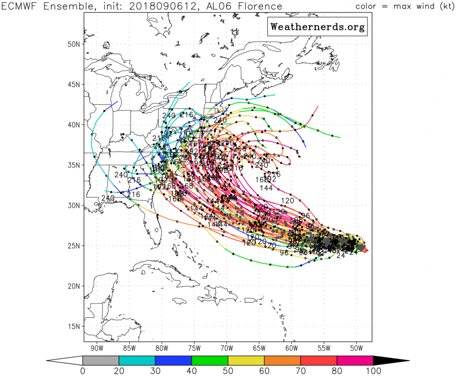
12Z Euro is running out to 24 hours
-
GGEM Takes it into Savannah.
-
Just by watching model trends I am beginning to believe this will end up being much more concerning and will end up being devastating for a lot of North Carolina.

-
 1
1
-
-
Not pretty for NC.
https://weather.us/model-charts/euro/2018090700/north-carolina/gusts-3h-mph/20180914-0000z.html
https://weather.us/model-charts/euro/2018090700/north-carolina/gusts-3h-mph/20180914-0600z.html
https://weather.us/model-charts/euro/2018090700/north-carolina/gusts-3h-mph/20180914-1200z.html
-
2 minutes ago, shaggy said:
Yeah that would devastate Wilmington and myrtle beach but would be a miss here in greenville. Too far south moving the wrong direction. Now only 5 more days until we actually know more about the reality of the modeled death ridge.
Cuts almost due North between 168 and 192 looks like it passes almost directly over Greensboro or Winston Salem.
-
00Z ECMWF is not looking looking pretty for the Carolinas. Looking like a NC/SC border hit around hour 156. Running inland along the NC/SC border at 168.
-
Nice snow forecast in Quebec.

-
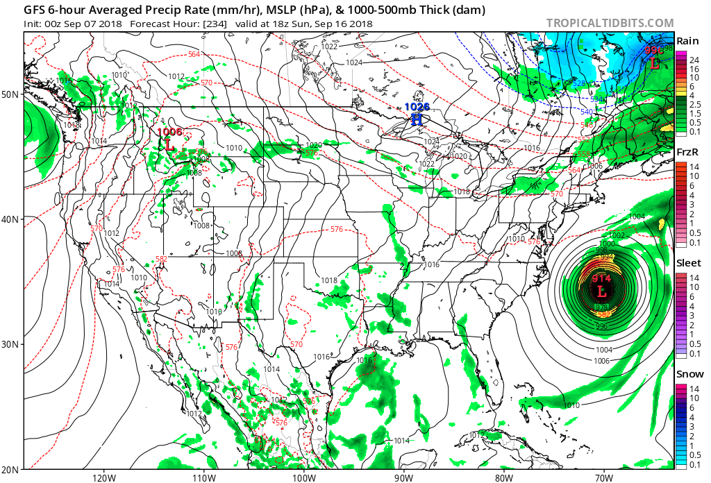
18Z HWRF and HMON are both coming in significantly SW of their 12Z runs. 18Z FV3 run is also coming in significantly further S then the 12Z run.
-
12 EPS ensemble
-
6 minutes ago, FallsLake said:
Yeah the euro is a hit around Ocracoke. Still way out..
Then turns NNE.
-
14/11/4
June 2/1/0
July 2/2/0
August 3/2/1
September 4/3/2
October 2/2/1
November 1/1/0
-
 1
1
-
-
2 minutes ago, Cold Rain said:
Can’t wait to hear the following in a few:
1) Wave not digging quite as much.
2) Looks like a later phase incoming.
3) Not gonna cut it this run
4) I don’t understand why the precipitation isn’t farther west.
5) Nam caving to the GFS.
6) Oh well, on to the GFS.
In other words same old same old.
")
-
1
-
-
6 minutes ago, WidreMann said:
Then again, this is the same trend we've seen the past few days. 06z and 12z move west. Everyone rejoices. 18z backs off and 00z holds. People freak out.
NAM is running lets see if it holds.
Hurricane Florence
in Southeastern States
Posted
From the NWS Raleigh AFD kind of ominous.
While the risk of impacts associated with Florence along the East Coast has increased, there is too much model spread/uncertainty to speculate what kind of impacts we can expect here in central NC. Given current model projections, impacts, if any, will be possible during the mid to late week period. Residents of central NC are strongly encouraged to closely monitor the latest forecasts and to ensure everyone has emergency kits and hurricane plan in place. It is never too early to prepare!