

ncskywarn
-
Posts
540 -
Joined
-
Last visited
Content Type
Profiles
Blogs
Forums
American Weather
Media Demo
Store
Gallery
Posts posted by ncskywarn
-
-
7 minutes ago, ryan1234 said:
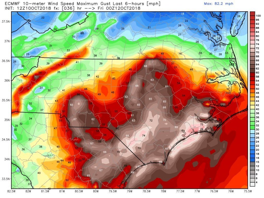
I'm curious to as to how strong winds will get for the Carolina's, especially along and east of I-85. Looks like you are going to get some pretty significant gusts as well. I'm in Union County, NC which is under a Tropical Storm Warning.
-
SUMMARY OF 1100 PM EDT...0300 UTC...INFORMATION
-----------------------------------------------
LOCATION...34.0N 76.8W
ABOUT 50 MI...80 KM S OF MOREHEAD CITY NORTH CAROLINA
ABOUT 60 MI...95 KM ESE OF WILMINGTON NORTH CAROLINA
MAXIMUM SUSTAINED WINDS...90 MPH...150 KM/H
PRESENT MOVEMENT...NW OR 305 DEGREES AT 6 MPH...9 KM/H
MINIMUM CENTRAL PRESSURE...956 MB...28.23 INCHES
-
SUMMARY OF 1000 PM EDT...0200 UTC...INFORMATION
----------------------------------------------
LOCATION...34.0N 76.7W
ABOUT 50 MI...80 KM S OF MOREHEAD CITY NORTH CAROLINA
ABOUT 70 MI...115 KM ESE OF WILMINGTON NORTH CAROLINA
MAXIMUM SUSTAINED WINDS...100 MPH...160 KM/H
PRESENT MOVEMENT...NW OR 305 DEGREES AT 5 MPH...8 KM/H
MINIMUM CENTRAL PRESSURE...956 MB...28.23 INCHES
-
 1
1
-
-
Just now, Wow said:
That was the last fishing pier in Atlantic Beach. Sportman's pier was closed back in '06
According to the Mayor that was a erroneous report anyway. That's why I deleted it.
-
GFS at 36 almost identical to 18Z. At 66 just a little East of 18Z.
-
GFS at 36 almost identical to 18Z. At 66 just a little East of 18Z.
-
 1
1
-
-
Looks like Northern model trends continue next up GFS
-
1 minute ago, Disco-lemonade said:
yea sorry crashed right when i posted try this one
Sorry I deleted my reply it started workingf again.
")
-
ICON is West at 21. Edit: makes landfall near North Topsail at 33 and is moving West inland at 48.
-
ICON is West at 21
-
ICON is West at 21. Edit: makes landfall near North Topsail at 33 and is moving West inland at 48. Edit: Looks like Northern model trends continue next up GFS
-
20 minutes ago, Hoosier said:
I wouldn't use the NAM pressure to extrapolate the strength at landfall. Look what it initialized at compared to what it actually is. Something like the HWRF may do better but even then it's tricky.
Only reason I'm even using it at all is we are within 36 hours and both Reg and 3K NAM are significantly North of 18Z. Not using it for landall strength. Edit after moving maybe 20-30 miles between hours 42-57 it moves SW and parks near Charlestion at hour 66 until 75. Then starts moving W and is on the SC/GA border at the end of it's run at hour 84.
-
NAM is NW made landfall near Wilmington at hour 33 moving W at hour 36 & 39 stalled on the NC & SC border at 42 & 45. Edit: still stalled same place hour 51.
-
NAM is NW made landfall near Wilmington at hour 33 moving W at hour 36 & 39 stalled on the NC & SC border at 42 & 45. Edit: still stalled same place hour 51.
-
1
-
-
20 minutes ago, Ser Pounce said:
Especially when it seems like everything has been trending south for a while now. I'm anxiously looking forward to the NHC's next update. I'm also curious about how they handle all the models that keep showing southwest movement off the coast on this one.
Todays modle runs have ttrended ever so slightly north.
Just now, StormFollowerUSA said:What CLT?
Charlotte
-
Here is the 240 hour 12Z Euro map.
-
GFS takes Florence as far NW is Eastrern KY at hour 156 then turns back SW thru Western NC at hour 168 to about the midpoint of the SC/GA line at hour 180 with the remnants about to emerge back into the Atlantic off the Southern coast of SC at hour 186. Edit: Actually turns SW again and emerges off the Florida panhandle into the GOM at hour 204.
-
21 minutes ago, Blue_Ridge_Escarpment said:
Man the GFS turns near S.C./GA line and heads to WNC. Wrings the moisture out.
GFS takes Florence as far NW is Eastrern KY at hour 156 then turns back SW thru Western NC at hour 168 to about the midpoint of the SC/GA line at hour 180 with the remnants about to emerge back into the Atlantic off the Southern coast of SC at hour 186. Edit: Actually turns SW again and emerges off the Florida panhandle into the GOM at hour 204.
-
1
-
-
Still moving SW just inland approaching the GA border at hour 114. Edit: Turns West into GA at hour 120.
-
Still moving SW just inland approaching the GA border at hour 114. Edit: Turns West into GA at hour 120.
-
 1
1
-
-
Landfall in SC from the NE moving SW at hour 102 looks like between Myrtle Beach & Charleston
-
Landfall in SC from the NE moving SW at hour 102 looks like between Myrtle Beach & Charleston

Hurricane Michael
in Southeastern States
Posted
Not to mention the NC State Fair is suppose to open tomorrow afternoon.