

ncskywarn
-
Posts
540 -
Joined
-
Last visited
Content Type
Profiles
Blogs
Forums
American Weather
Media Demo
Store
Gallery
Posts posted by ncskywarn
-
-
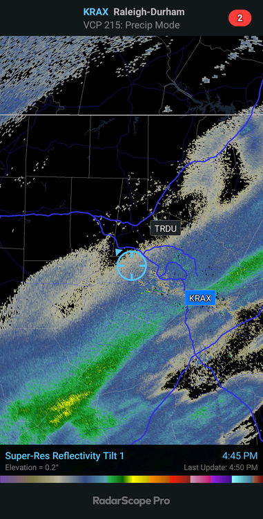
Started snowing in Western Cary, Carpenter area about 10-15 minutes ago. Small flakes but it is snowing.
-
1 hour ago, wake4est said:
I would sell a non-vital organ for the fantasy GFS to verify.
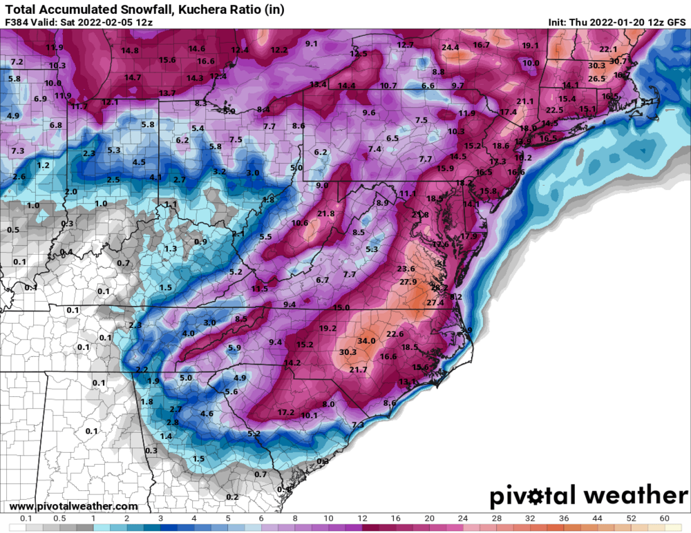
To make it even more laughable Wake County gets more snow on that map then anywhere else in the United States or Canada.
-
 2
2
-
-
3 minutes ago, wake4est said:
Got the Kuchera for the 6z?
-
1
-
-
12 minutes ago, BornAgain13 said:
Yeah the HRRR looks nothing like the Euro. Precip way east and off shore...
Someone on Southern Weather said that the HRRR uses the same algorithm that the RAP uses. So that really is not unexpected or surprising.
-
 1
1
-
-
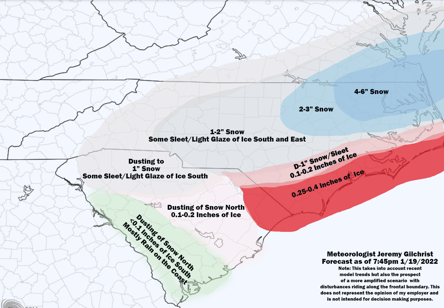
10 minutes ago, eyewall said:
Call Map as of 7:45pm

Even is the models trend back with more QPF do you really think that Western Wake County will only be in the 1-2 inch range?
-
4 minutes ago, TARHEELPROGRAMMER88 said:
What is different on the ECMWF as compared to the GFS with precip coverage?
WAR flexed just enough to slow down the NS and allow the SS to catch up just a little.
-
 1
1
-
-
7 minutes ago, WxSynopsisDavid said:
Honestly, if the low could be a little deeper and undergo bombogenesis that would be really nice and everyone in the subforum would cash in and be able to eat lol
Not necessarily because that would cause WAA mixing issues and a lot of ice. That many of us don't want to see.
-
RDU SERF
-
14 minutes ago, ncskywarn said:
Still rain/snow mix Cary Park area of West Cary.
Just changed over to all snow now.
-
2
-
-
Still rain/snow mix Cary Park area of West Cary.
-
Not sure if this has been posted before but Interesting read.
https://observer.com/2019/08/weather-forecast-noaa-prediction-models-accuracy/
-
FYI now a hurricane:
: ...DORIAN BECOMES A HURRICANE NEAR ST. THOMAS IN THE U.S. VIRGIN ISLANDS... ...MULTIPLE OBSERVATIONS OF HURRICANE-FORCE WINDS IN ST. THOMAS...
2:00 PM AST Wed Aug 28
Location: 18.3°N 65.0°W
Moving: NW at 13 mph
Min pressure: 997 mb
Max sustained: 75 mph -
3 minutes ago, shaggy said:
Little ticks north in the models. Wouldnt shut Dorian out of our minds here just yet.
Big part of it was the fact the the eye reformed something like 75 miles further to the North of the old center today.
-
4 hours ago, downeastnc said:
94L isnt looking horrible this afternoon, still with the big front ( for July anyways ) coming there is little threat of anything too major happening, if it somehow made it far enough north or even inshore over SC/MC it could bump rainfall totals quite a bit though.....
3 hours ago, WxWatcher007 said:I’ll tell you what, it’s looking pretty solid right now. Up to 60 percent odds now.
Now TD 3. but not forecasted to become a TS.
000
WTNT43 KNHC 222032
TCDAT3

Tropical Depression Three Discussion Number   1
NWS National Hurricane Center Miami FL       AL032019
500 PM EDT Mon Jul 22 2019

Deep convection has increased in association with the small low
pressure area we have been monitoring near the Bahamas.  Animation
of visible satellite images and scatterometer data indicate that a
closed low-level circulation formed today, and therefore advisories
are being initiated on the system.  Conventional surface
observations along with the scatterometer measurements indicate that
the maximum sustained winds in the cyclone are near 25 kt. The
system is in a marginally favorable environment for strengthening,
as a special 1800 UTC sounding taken by the National Weather Service
Forecast Office here in Miami showed a layer of dry air near the 700
mb level.  The global models do not intensify the system, and only a
slight increase in strength appears likely.  In 36 to 48 hours, the
models indicate that this system will be absorbed by a frontal
trough near the U.S. east coast.

The initial motion estimate is northwestward or 305/11 kt.  Over the
next day or so, the tropical cyclone should move around the western
periphery of a mid-level subtropical ridge, with the center of the
depression expected to remain offshore of the Florida east coast and
the southeastern United States until dissipation.  The official
track forecast follows a small consensus of the only models that
were able to follow the center of the depression in the predicted
fields.

FORECAST POSITIONS AND MAX WINDS

INIT  22/2100Z 25.6N  78.6W   25 KT  30 MPH
 12H  23/0600Z 27.2N  79.7W   30 KT  35 MPH
 24H  23/1800Z 30.1N  79.6W   30 KT  35 MPH
 36H  24/0600Z 33.7N  77.8W   25 KT  30 MPH
 48H  24/1800Z...DISSIPATED

$$
Forecaster Pasch
-
It went operational as of the 12Z run today.- (12 Jun 2019) The operational GFS has been upgraded to the FV3 core as of this morning's 12z run.
-
(12 Jun 2019) The operational GFS has been upgraded to the FV3 core as of this morning's 12z run.
-
1 hour ago, AsheCounty48 said:
Are there livestreams of any sorts to watch everything out west? I've try looking but I can't find anything good.
-
We have Andrea
000
ABNT20 KNHC 202149
TWOATSpecial Tropical Weather Outlook
NWS National Hurricane Center Miami FL
550 PM EDT Mon May 20 2019For the North Atlantic...Caribbean Sea and the Gulf of Mexico:
Data from an Air Force Reserve reconnaissance aircraft indicate that
the low pressure system located several hundred miles southwest of
Bermuda has developed a well-defined center with maximum sustained
winds of about 40 mph. A special advisory will be issued on
Subtropical Storm Andrea by 6:30 PM EDT or 2230 UTC.
* Formation chance through 48 hours...high...near 100 percent.
* Formation chance through 5 days...high...near 100 percent.$$
Forecaster Zelinsky/Cangialosi -
Tornado Watch
WATCH COUNTY NOTIFICATION FOR WATCHES 88/91
NATIONAL WEATHER SERVICE RALEIGH NC
428 PM EDT FRI APR 19 2019

NCC001-007-037-057-063-067-077-081-085-093-105-123-125-135-145-
151-153-165-167-183-200000-
/O.EXT.KRAH.TO.A.0088.000000T0000Z-190420T0000Z/

TORNADO WATCH 88, PREVIOUSLY IN EFFECT UNTIL 5 PM EDT THIS
AFTERNOON, IS NOW IN EFFECT UNTIL 8 PM EDT THIS EVENING FOR THE
FOLLOWING AREAS

IN NORTH CAROLINA THIS WATCH INCLUDES 20 COUNTIES

IN CENTRAL NORTH CAROLINA

ALAMANCE              ANSON                 CHATHAM
DAVIDSON              DURHAM                FORSYTH
GRANVILLE             GUILFORD              HARNETT
HOKE                  LEE                   MONTGOMERY
MOORE                 ORANGE                PERSON
RANDOLPH              RICHMOND              SCOTLAND
STANLY                WAKE

THIS INCLUDES THE CITIES OF ABERDEEN, ALBEMARLE, ANDERSON CREEK,
ANGIER, ANTIOCH, ARCHDALE, ASHEBORO, ASHLEY HEIGHTS, BADIN LAKE,
BETHESDA, BISCOE, BURLINGTON, BUSHY FORK, BUTNER, BYNUM,
CARRBORO, CARY, CHAPEL HILL, CONCORD, CREEDMOOR, CUMNOCK, DUNCAN,
DUNN, DURHAM, EAGLE SPRINGS, EAST ROCKINGHAM, ELDORADO, ERWIN,
GRAHAM, GREENSBORO, GUM SPRINGS, HAMLET, HASTY, HIGH POINT,
LAKE TOWNSEND, LAUREL HILL, LAURINBURG, LEXINGTON, LILLINGTON,
MONCURE, MOUNT GILEAD, OXFORD, PEKIN, PFAFFTOWN, PINEHURST,
PITTSBORO, PLYLER, POLKTON, RAEFORD, RALEIGH, RESEARCH TRIANGLE,
ROCKFISH, ROCKINGHAM, ROXBORO, SANFORD, SEVEN LAKES, SILER CITY,
SILVER CITY, SOUTHERN PINES, STANLEYVILLE, SURL, THOMASVILLE,
TIMBERLAKE, TRAMWAY, TRINITY, TROY, ULAH, WADESBORO,
AND WINSTON-SALEM.

$$
-
8 minutes ago, frazdaddy said:
Tornado warning, Alamance, Chatham, Lee, Moore and Randolph
Lee County has been removed from the warning.
-
18 minutes ago, cbmclean said:
First I heard of this. What the heck happened?
Greg Fishel announcement
http://wr.al/1EK7j -
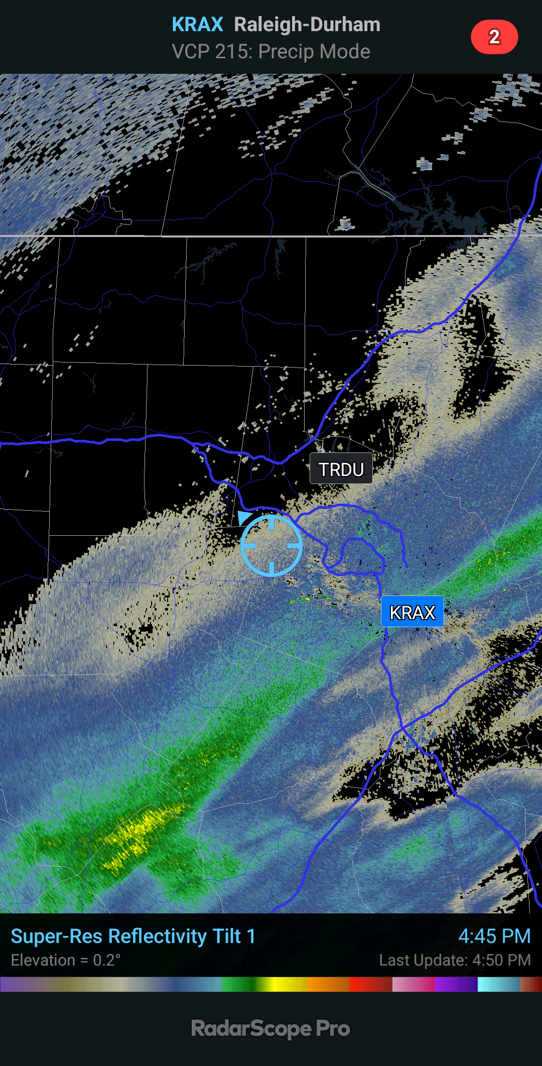
Per 00Z HRRR for RDU Verbatim it drops 9” of snow before mixing. we do start mixing on that run but we never flip to plain rain I'll take that for the win.
-
1
-
-
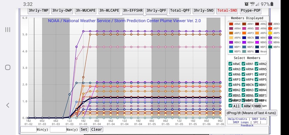
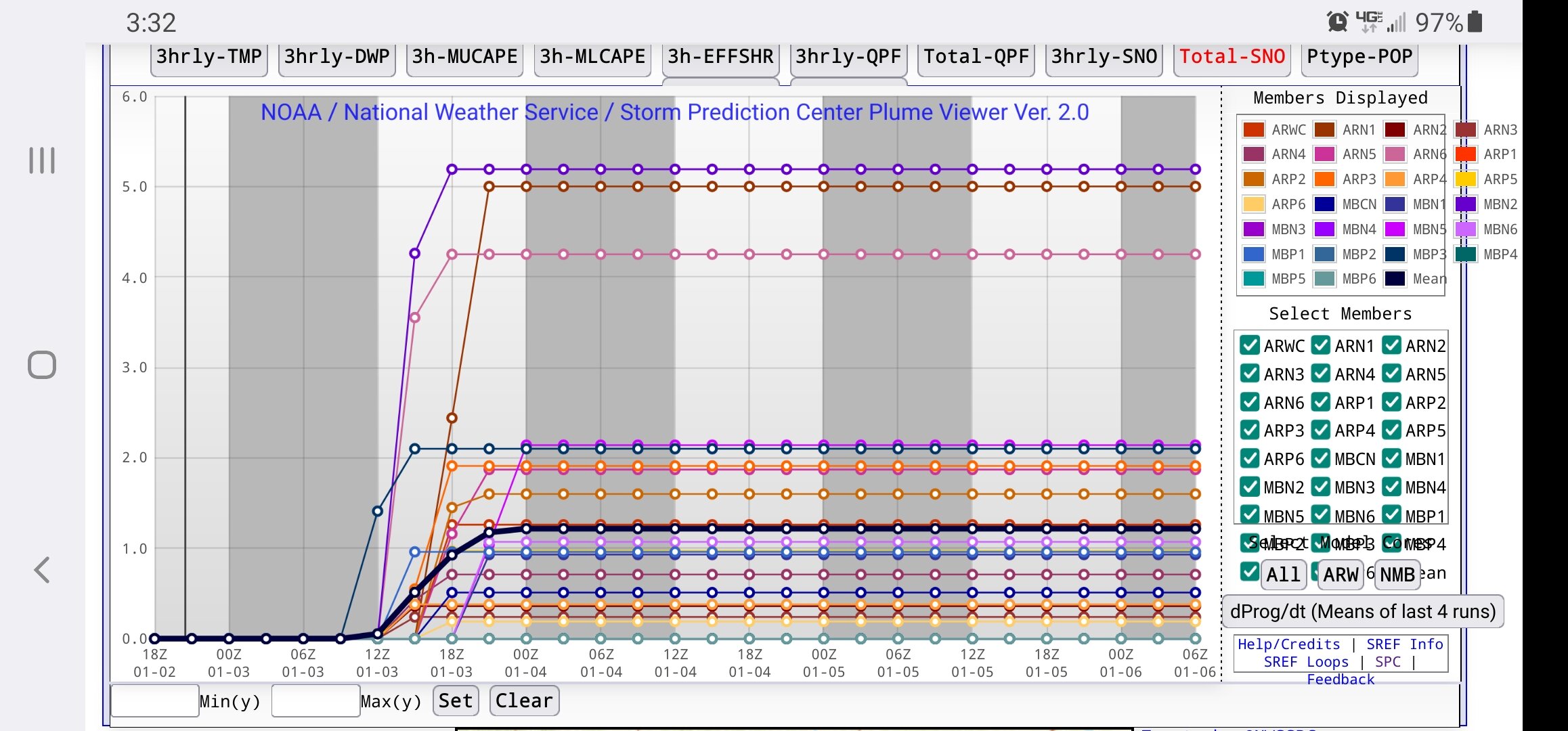
06Z GFS significantly further South compaired to 00Z at hour 96.
Edit: Ends up about the same place though at hour 120. By hour 150 the low ends up further North over the NC sounds just West of Hatteras. compaired to off the coast East of the NC/SC border a lot more rain then snow for a lot of people.

-
2
-
-
Just now, frazdaddy said:
delayed till Friday
Smart idea
")

Mid to Long Range Discussion ~ 2023
in Southeastern States
Posted
This would be ugly.