

MD Snow
-
Posts
1,875 -
Joined
-
Last visited
Content Type
Profiles
Blogs
Forums
American Weather
Media Demo
Store
Gallery
Posts posted by MD Snow
-
-
2 minutes ago, Ralph Wiggum said:
Not basing things verbatim off of models....just using them as a blend for guidance. Especially weighing more heavily on the ens still ar this range. If I were just looking at the cmc or gfs then I might agree. But looking at the overall flow across N America and into the Atl region, looking at ens members and means, and looking at recent systems as well as traditional Nina regimes, this one just isn't giving me the warm fuzzies. I'm done debbing (though just being realistic tbh) on this one...its the last I will mention my thoughts on it for today in lieu of upsetting folks which isn't my m.o.
Makes sense. I agree. General pattern does not scream a wrapped up, slow moving coastal. Best case is quick moving coastal with 2-4" - 4-8".
-
5 minutes ago, Ralph Wiggum said:
There's always a chance. Up until Saturday there's a chance. But with the progressive pattern and no blocking it is going to take a change of mass proportion to get this to begin trending into a coastal hit. If we had some support or the mentioned blocking I think more realists would side with you Randy. But this is like the 1980 USA Olympic hockey team walking into qualifiers....a chance but probably need a miracle.
Wait...12z GFS gives us flakes with a dusting to an 1". 12z CMC gives the corridor 2-4" with 4-8" on the shore. Pretty close on those two models to being a bigger hit for us. A few minor tweaks with those runs and we have a coastal hit. We don't need some change of massive proportions with those 2 model runs.
Some runs are well off shore and some are a LOT closer. Still a wide range of possibilities. Models are split on OTS or closer to the coast. Until the land on a general solution we're still in the game. Could go either way. If the final solution is closer to the coast like GFS and CMC then we can start discussing details...like Miller B screw job, lack of precip etc...
My main point is that, this could still turn into something special for us and it could still completely screw everyone along the east coast. Models are split.
-
9 minutes ago, Ji said:10 minutes ago, stormtracker said:it's gonna miss. trof really never goes neg tilt. Next time fellas and ladies
Euro always ruins a good start
Super low expectations with this one but I have to point out that this time last week the euro was showing like 12-20" for this past Friday/Saturday. Que Ji with his, "When the euro shows snow it never snows" rants...
Edit...actually it's 0z run last Sunday morning was 2' for dc. It's 18z last Monday afternoon was 19" for dc... just saying...
-
May have already been mentioned but for the Tuesday/Wednesday deal...noticed ICON and GEM are speeding up the NS. ICON gets if out of the way fast enough allowing the SS to amplify with the boundary south of us.
-
-
Just now, yoda said:
Looks like better phasing on the 18z
Compared to 12z?
-
latest hrrr has a band of sleet/snow coming through the metro's between 6-8am tomorrow morning.
-
 1
1
-
-
2 minutes ago, Chase said:
The Winter Storm Watch is still showing in my point forecast. Is it still up too?
Yeah. Same for me. I'm wondering if LWX still thinks they may have to upgrade to a warning at some point.
-
9 minutes ago, WxUSAF said:
WBAL is saying widespread coating-1” of snow before ice tomorrow. This is apparently all due to the IBM GRAF model.
Extended 18z hrrr and 18z rgem also support some snow to start for northern areas.
-
Just now, Ji said:
didnt mean anything...euro shows a warm rain on tuesday. Wow
Just now, clskinsfan said:Euro is one hell of an ice storm on Tuesday. Although it has been over amped all winter.
Nice work guys!
-
 9
9
-
-
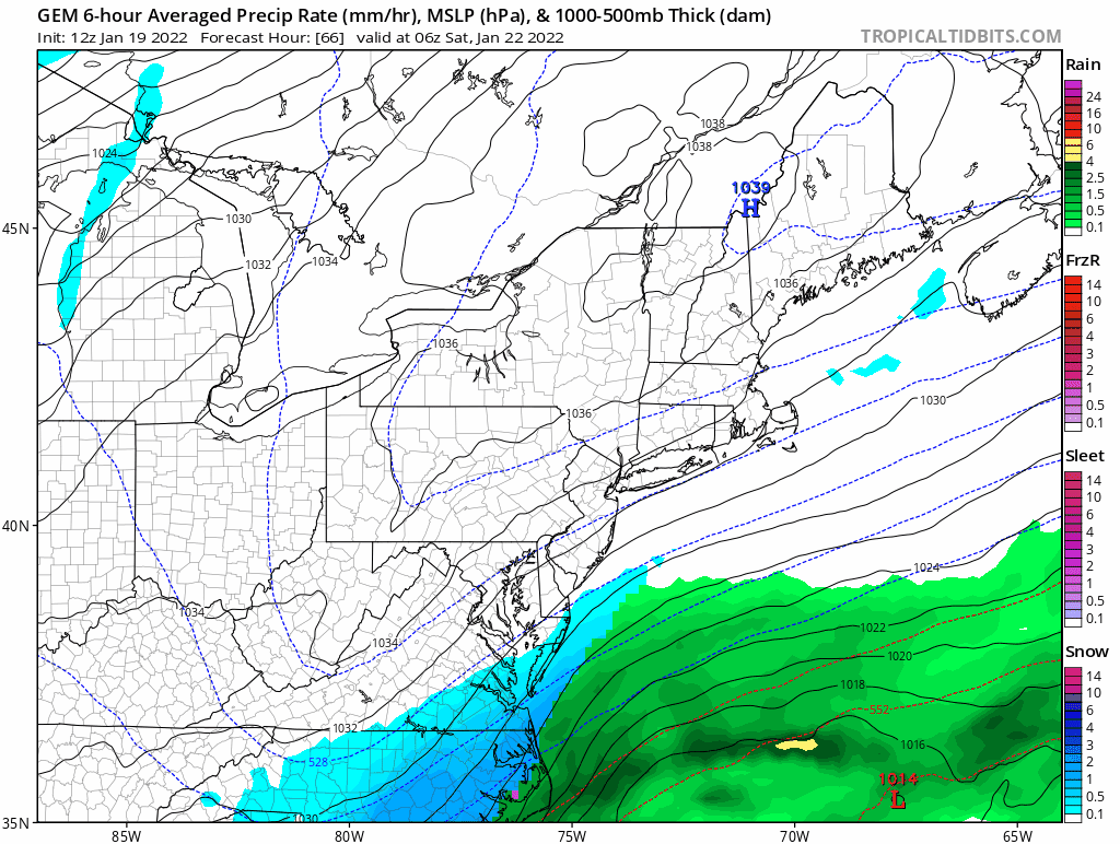
Nice 1034 hpc in quebec for Thursday as precip moves in on the 12z gfs. Doubt the cold erodes as fast as shown.
-
1
-
-
7 minutes ago, LP08 said:
Thursdays storm looks colder....that's the one!
Couldn't it help the Thursday system, if the Tuesday system ends up being a little more amped? Could leave lower heights behind it and more of a colder push in front of the Thursday system.
Also, GFS has tended to be overly amped in the medium range. 72-120hrs out.
-
-
It'll be interesting to see how long it takes to flip from a r/s mix to all snow once precip arrives. Is there a chance we start as all snow? Seems like most models have areas around and S/E of 95 getting close to .1" of precip before we flip to snow completely. A quicker flip would be a good sign for accumulation imo.
-
-
Just now, Baltimorewx said:
Right or wrong GFS ain’t budging. Just really low QPF
It's trended weaker with SLP each of it's last 4 runs.
-
1
-
-
3 minutes ago, psuhoffman said:
It is less amplified...but it is also slower so it is hard to compare since the wave is amplifying more later across guidance.
Yes. Noticed this. It's actually more in line with the timing of RGEM and HRDPS now. Previously, it was about 3 hrs earlier than other guidance on the start time.
-
2 minutes ago, MDRandy said:
You're gonna have the weenie police all over you for that post.
Know your climo. I live east of 95. Every once in a while we score but unfortunetely, I've seen this one play out time and time again....
-
2
-
-
FWIW ICON has ticked the rain/snow line further west each of its last 4 runs. That run was mostly rain for many areas on the eastern shore. One more tick and we're talking mixing into the I95 corridor.
-
1 minute ago, psuhoffman said:
It looked like it there...but then the low took a NE instead of NNE track from NC and the heavy precip stayed southeast of 95. Close miss to the SE with the heavy snow.
Don't you think the NE turn is because the wave in the plains was faster ejecting and further east this run?
-
ICON has the next wave further east this run. It seems to not allow the sw to amplify as much when it gets to our latitude. A step back from it's 18z imo.
-
GFS looks more amped through hr 54.
edit...
It's really nice!
-
1
-
-
6 minutes ago, CAPE said:
This will be yours in the end dw lol.
Couldn't agree more. If this actually does happen, it has areas with elevation written all over it. This is the kind of setup where the cities/coastal plain get Snow TV while PSU jackpots with 6-10".
-
 1
1
-
 1
1
-
-
57 minutes ago, jayyy said:
little too far out to trust a hi-res model
Yeah. Agreed. Hence the FWIW. Simply mentioned to show that there appears to be a trend towards a more amplified, further west solution.
January 28-29, 2022 Miller abcdefu Storm Threat
in Mid Atlantic
Posted
6z Nam leaves all the SW energy behind. It’s apparent early on too.