

MD Snow
-
Posts
1,875 -
Joined
-
Last visited
Content Type
Profiles
Blogs
Forums
American Weather
Media Demo
Store
Gallery
Posts posted by MD Snow
-
-
Just now, CentralVaNATS said:
Dont you know there is a separate thread for Digital Snow posts??? But yea lock it up for a WIN
Sent from my SM-N960U using Tapatalk
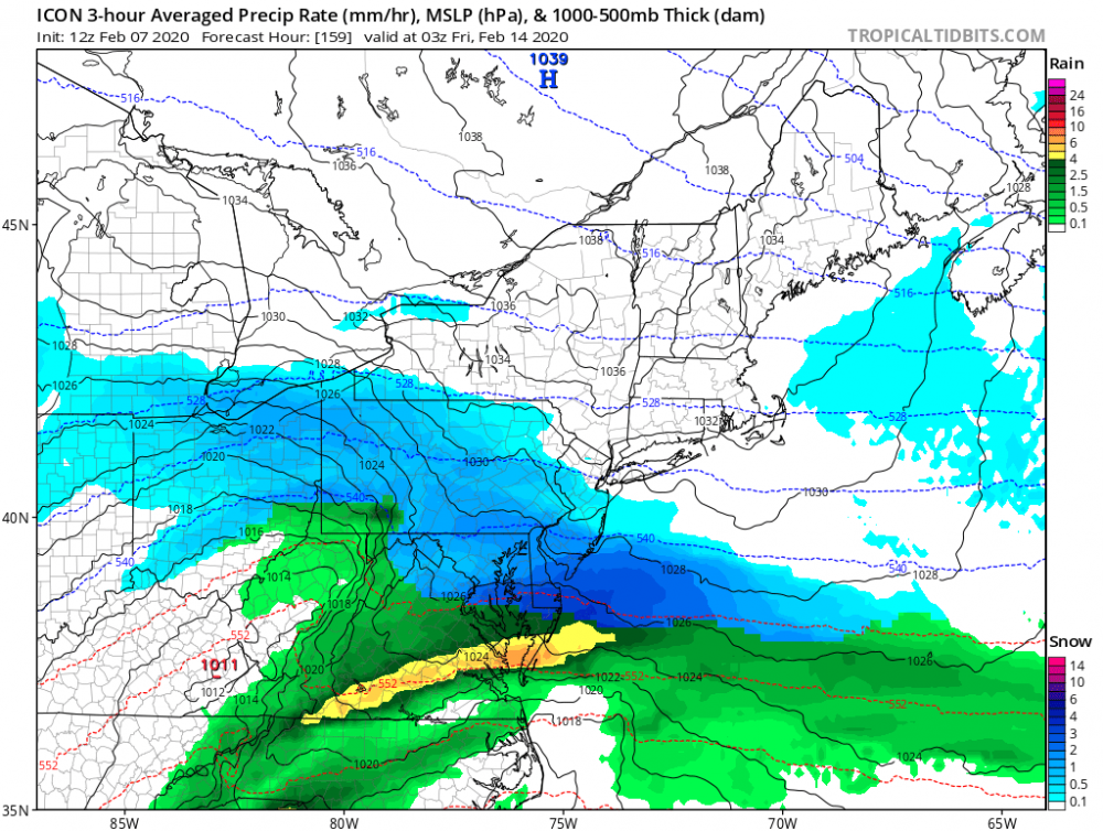
It's not a digital snowfall map.
-
Just now, Amped said:
Has a closed 500 mb low right in the middle of a ridge.
Yup. Haha...GFS showed something similar during this time frame at 6z.
-
Lock it up.

-
 1
1
-
 1
1
-
 2
2
-
-
Not that it makes a difference for us but definite trend south for wed night/Thursday morning deal on op gfs the last 3 runs. Slower with S/w and faster with NS.
-
1 minute ago, Weather Will said:
Only bone I have to throw this am is that PNA is moving in the right direction toward the end of the month in 0z EPS ensembles. Looks like we punt the rest of February. Maybe we will start to see improvement in our final few weeks of winter and end with a snow storm. But I would not bet the ranch on it.
What about a bunny?
-
I'm only looking at TT 24hr maps but the EURO didn't make any positive trends. Maybe worse?
-
6 minutes ago, Bob Chill said:
Checking under the hood of the cmc, here's surface temps at 7am thurs with precip knocking on the door. How snowy does this look?

True, but if we have northerly winds and boundary pressing in from the north, lpc tracking south of us, it wouldn't really matter once precip started, right?
-
2 minutes ago, Bob Chill said:
Neither. Just sit back and wait until all models look the same. Nothing will be decided in advance until we have that. Based on recent runs we aren't remotely close to consensus yet. Just watch and understand that this is not an easy way to get anything. Even if the mids are good, what will the surface look like?
It's really astounding how the CMC, GFS, ICON are all semi close to an event, at least for northern areas, while the EURO is like on a completely different planet.
-
1 minute ago, Ralph Wiggum said:
ICON is a crusher 40 N
Very similar to 6z GFS and 0z Canadian.
-
1 minute ago, Ralph Wiggum said:
I dont see the NS feature getting out front or the ss feature slowing. More confluence over the NE is a benefit tho. I guess we grasp at any positive we can find.
If I were you, I'd be hugging the snot out of what the ICON just spit out.
-
ICON is looking decent early on. Cold pressing much more than 6z while S/W wave is more suppressed but still coming up at a good time.
-
30 minutes ago, Ji said:59 minutes ago, C.A.P.E. said:0z EPS had 3 out of 50 members that gave decent snow to the I-95 corridor through next weekend.
It can only trend better from there.

That's up from 2 of 50 at 12z
Baby steps, right?
If this is going to be a total non event, I hope the American models get their act together today and stop messing with us.
-
7 minutes ago, Weather Will said:
Folks, this winter has proven that if The King is not on board forget about it. Until or if its look improves don’t overthink or get false hopes looking at the Goofus.
Any improvements at 6z?
-
4 minutes ago, yoda said:
still all rain
Come on yoda. It’s an 95 north and west special. Gonna make the weenies cook themselves.
-
Just now, Ji said:8 minutes ago, Ralph Wiggum said:But its almost across the majority of guidance now with even individual ens members jumping to the same looks. Again like said earlier, there is plenty of time still but the way this is unfolding is the same exact process we have seen the entire winter. There is just no getting around that right now.
This is your week and your storm. Do a better job defending your storm man!
CMC might give us something positive to write about. At least for one more night.
-
Just now, Maestrobjwa said:
And yet it was there two runs ago. This time the high comes in late. So that's three runs, three different solutions, lol
Exactly. Worst model out there right now.
-
3 minutes ago, WinterWxLuvr said:
LOL at some of these posts. GFS comes in much more supressed, but the models are converging. LOL. They are all over the place at 500. Just toggle between runs starting at about 96 hours.
It doesn’t matter. No cold air. No high to the north.
-
1
-
-
6 minutes ago, Maestrobjwa said:
Yeah, the models got this one locked in real good...lol Gonna be a wild tracking weekend/week!
It actually appears that they are all coming closer to a final solution. It’s pretty obvious. The artic front is lagging behind the s/w now across all guidance. Thus we have no real cold air source. The gfs and icon had the front coming in at the right time to provide cold and a nice HP to the north. They’ve lost that now. Lagging behind. The euro has always been lagging the front behind.
-
19 minutes ago, Bob Chill said:
12z gefs doesn't support the suppressed solution much at all. A mix of ok hits and/or rain for the most part. Decent agreement that the shortwave/ULL makes a run at us. Some west tracks in there for sure.
ETA: after looping the member solutions there is a cluster with a slider. Pretty much an equal mix of slider, snow, mixed, and rain. Basically the GEFS says all options on the table and the model has no idea what will happen yet.
Yeah, 24hr precip panel for the period look worse than at 6z or 0z. .75 line went from southern md at 6z to southern va at 12z. Sounds like a good number of whiffs or supresssd looks.
-
6 minutes ago, Solution Man said:
CMC gonna play
Nope. Slides south. Which isn't a bad thing at this range. It's still close.
-
1
-
-
3 minutes ago, Ralph Wiggum said:
GFS is improved but I'm not sure it is handling the NS correctly and is likely up to its antics of overdoing the cold push. Better baby steps so far at 12z. At least @Ji now has the digital snow on some guidance he was begging for last night.
I'd like the GFS to stay south until about Monday night, honestly.
-
1
-
-
GFS is closer. On to the CMC and EURO. My guess is the model war currently going on between gfs and euro will be resolved by tomorrow 12z if not sooner.
-
1
-
-
From here it stalls and transfers to the coast, warms slightly but then begins to wrap back up at the end of its run. Ji will be happy.
-
1 minute ago, showmethesnow said:
Says the guy who started a thread for a couple rain showers last weekend...haha!
-
5
-
February Medium/Long Range Discussion
in Mid Atlantic
Posted
LOL. Any other year and we'd laugh at that. This year? I say "wow"! That's almost a 1 and 5 chance.