
Superstorm93
-
Posts
8,230 -
Joined
-
Last visited
Content Type
Profiles
Blogs
Forums
American Weather
Media Demo
Store
Gallery
Posts posted by Superstorm93
-
-
Recon is finally departing. Looks like we'll have a fix in a few hours.
-
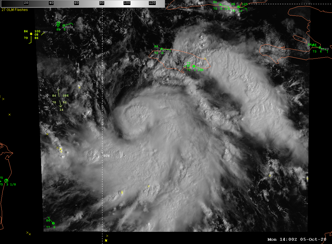
Convection really exploding in the northern portion of the circulation.
Banding has improved considerably as well.
-
11 minutes ago, Cheeznado said:
Way too weak for any real eye to be present. Regarding landfall intensity I think that fairly rapid weakening right at the coast is likely due to cooler water and shear, it all depends on how strong it gets in the central Gulf. I noticed that the HWRF backed off of the intensity quite a bit with the 06Z run.
They may be overestimating the amount of shear coming from Gamma. It's really hard to see this not blowing up.
-
The GFS sounding though...
-
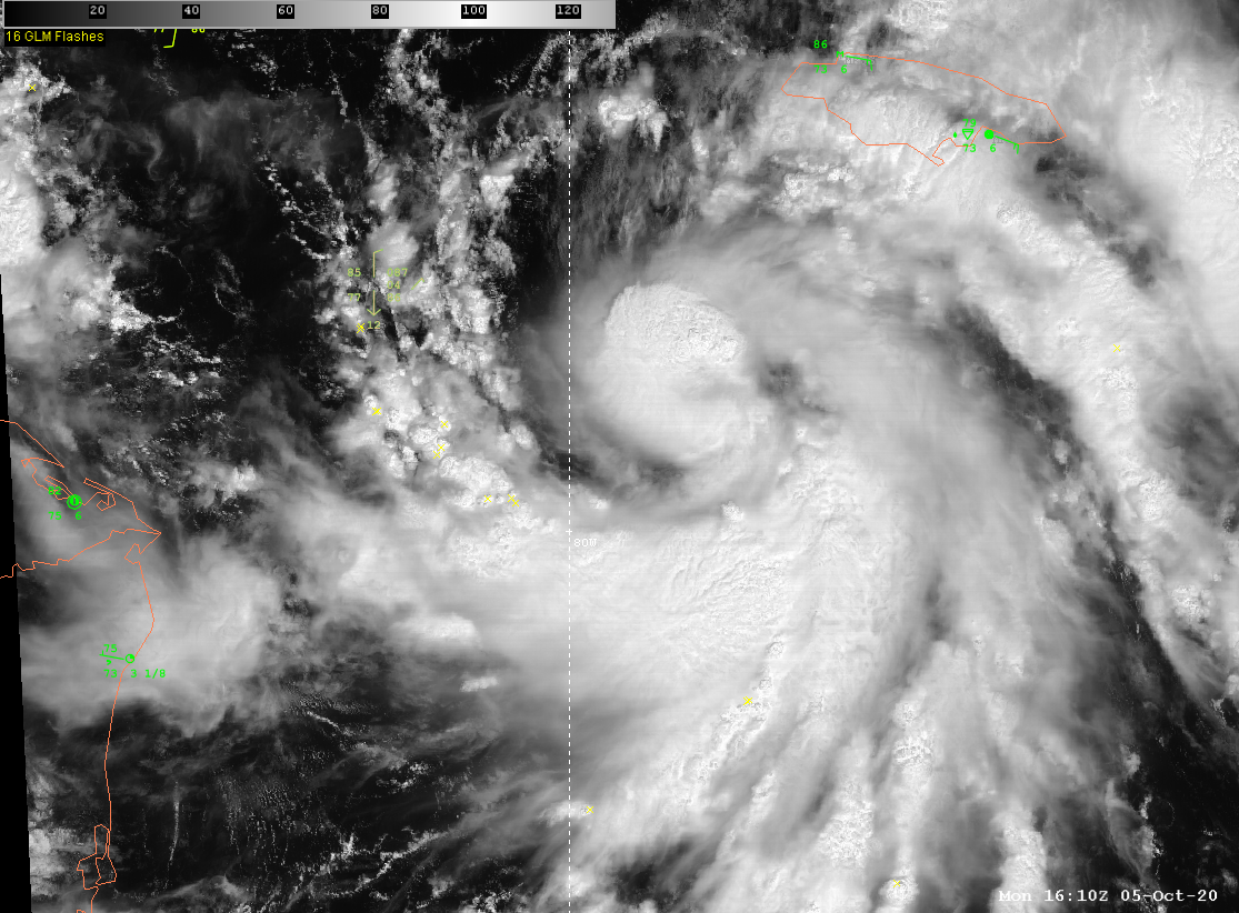
Delta is really starting to get that "look" to it this morning. Will be interesting to see if it can take advantage of the favorable conditions ahead..
-
Recon now reports that the eye is closed and only 6nm wide
-
 3
3
-
-
1 hour ago, wizard021 said:
https://www.tropicaltidbits.com/analysis/models/?model=gfs®ion=watl&pkg=uv200 the wind direction at 200 is southerly and in the same dir the storm is moving . This shows shear is in a favorable direction . The only detriment is speed shear . Cat 1 into Louisiana is a solid forecast. I expect continued up and downs in intensity as recon has showed so far.
-
 1
1
-
-
VDM has 994mb with no eye available.
This is why its not appropriate to run around saying this is rapidly intensifying.
-
2
-
-
Pressure up a bit on the latest pass with winds in the 55-60 knot range. Would be nice to get a decent NE quad pass to see if this is actually a hurricane.
-
1
-
-
Last VDM had the eye down to 4nm but still open to the SW
We'll see how long Marco can hold up against the shear and dry air to it's west.
-
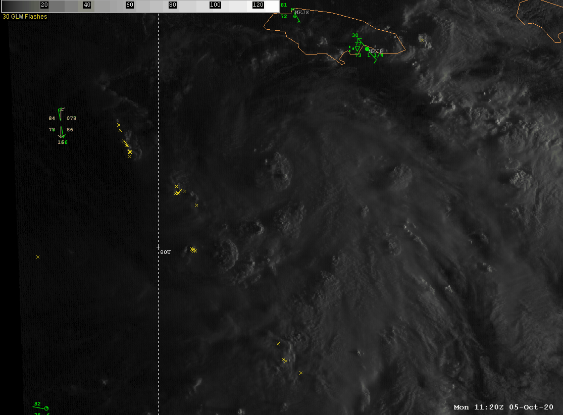
Recon not finding any impressive pressure readings so far.
Still might be an open wave at this point.
-
Looks like the GFS wants to bring down another TUTT ahead of the system behind 97L and shear/land interaction eventually kill the system off. Pretty notable changes with regards to TCG in general, but we're still a long ways out from knowing is this has a shot at surviving past the islands.
97L should have a pretty decent environment in the Western Caribbean later this week, but we'll see it if it can slow down to take advantage of it.

-
2
-
-
New SPC MD
QuoteShort-term model guidance has trended away from a possible scenario
of discrete storm development over south-central OK. The most
probable scenario involves several tornadic supercells likely moving
across southwest OK and approaching the I-40 corridor west of the
OKC metro. -
-
Just now, wotan said:
I meant watch.
Usually reserved for widespread damaging wind events.
Here's an example https://www.spc.noaa.gov/products/watch/2017/ww0280.html
-
2
-
-
-
At 1103 AM CDT, a confirmed large and extremely dangerous tornado was
located near Calvert, or near Hearne, moving northeast at 30 mph.This is a PARTICULARLY DANGEROUS SITUATION. TAKE COVER NOW!
-
At 1051 AM CDT, a confirmed tornado was located near Hearne, moving
northeast at 35 mph.HAZARD...Damaging tornado and quarter size hail.
SOURCE...Radar confirmed tornado.
-
Even more bullish for 16z tomorrow...

-
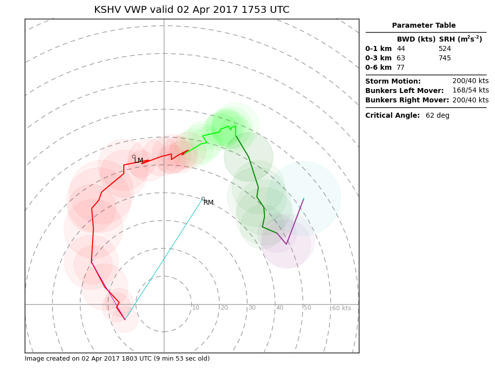
Just for the sake of posterity, here's an observed hodo derived from the VWP @ SHV from 4/2/17
-
-
Just now, yoda said:
Do you have a link to that? That doesn't look good at all
Sure
-
1
-
-
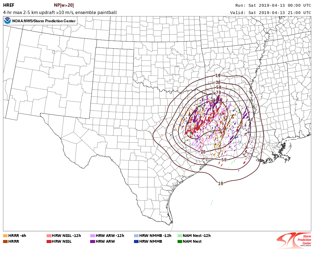
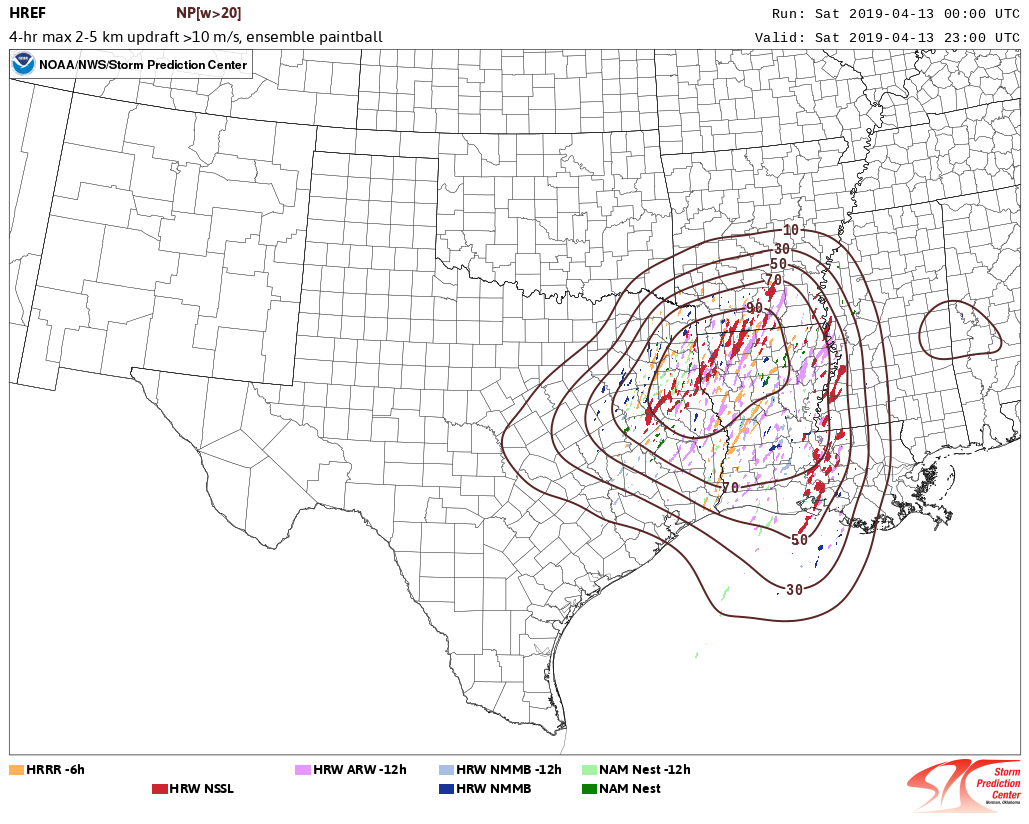
00z HREF
-
Shame that the HRRR-TLE tornado probs aren't being run for this event (yet)
The SSCRAM+HRRR SWG has things starting to kick off pretty early AOA 14z over TX tomorrow morning
https://www.spc.noaa.gov/exper/hrrr/sscram/


Major Hurricane Delta
in Tropical Headquarters
Posted
Check out those new towers...