

Cheeznado
-
Posts
2,155 -
Joined
-
Last visited
Content Type
Profiles
Blogs
Forums
American Weather
Media Demo
Store
Gallery
Posts posted by Cheeznado
-
-
I think think the RI has paused for at least a little while based on the last few fixes and the fact the eye has not gotten any clearer. This is a very small storm compared to Gilbert and Wilma which may be a factor for now.
-
984 now, HWRF does not have it that strong until 06Z Wed, Hmmmm.
-
9 minutes ago, tiger_deF said:
Sure looks like an eye is trying to pop out, likely just a warm core feature
Way too weak for any real eye to be present. Regarding landfall intensity I think that fairly rapid weakening right at the coast is likely due to cooler water and shear, it all depends on how strong it gets in the central Gulf. I noticed that the HWRF backed off of the intensity quite a bit with the 06Z run.
-
This GFS storm is not the area that NHC is watching right now- that system, if it develops, would probably stay down by the Yucatan or Bay of Campeche. The second one originates in the southern Caribbean.
-
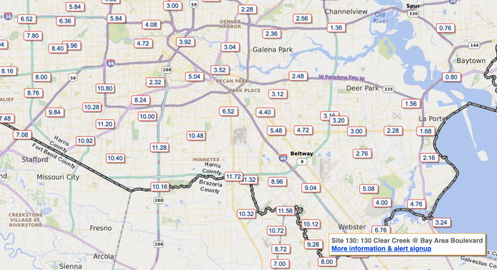
Radar estimates borne out by gauges- up to nearly 12"
-
11 minutes ago, Maestrobjwa said:
Uh...can we even say that yet? Isn't this thing supposed to be meandering for several days before landfall?
I said iffy, that is still very possible but there are some caveats. EDIT: well, now there is a burst of convection near the center. So who knows.
-
Center completely exposed, the latest HRRR has it too strong right now and even with that it weakens it to 40kts at landfall. So even the big flood type scenario is looking iffy right now.
-
 1
1
-
-
4.6" here total so far, about what I was expecting.
-
 1
1
-
-
New Euro stalls it on the lower TX coast, then moves it NE to the LA coast. This is similar to what the GEFS is hinting at. That would be a trip...
-
A Central America hit in any case....
-
That shear is forecast to decrease and retreat north as the UT weakens and retrogrades. The question is where will the storm be at that time- the weaker it gets the more westward it will go and get sheared even more but if it can stay stronger a bit longer it may go on a more northerly path and stay in a lighter shear area. Not saying it will be that big of a deal but it may not totally be "ripped to shreds" either.
-
1
-
-
Where NHC says the center is the plane found nothing even close to a circulation. I think maybe they jumped the gun in calling it a TD.
-
1
-
-
I find it rather interesting that despite the forecasts of a possible record # of storms it is awfully quiet right now (not counting that wimpy Josephine and the who-cares 96L off the Carolinas)- and none of the global models have much of anything through the end of the month- this is with the peak of the season approaching.
-
Latest synoptic models actually have this making landfall in the OuterBanks...
-
1
-
-
Overall this was a pretty big bust tornado wise, really only 5 separate reports so far. There will be a few more added after surveys but in general the large 15% hatched did not verify. Which is good news.
-
2
-
-
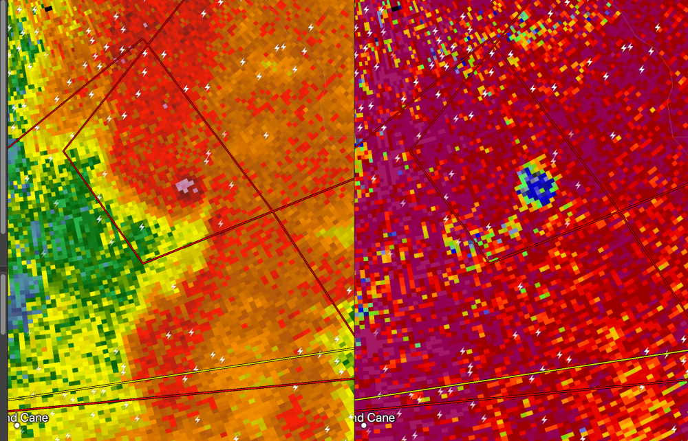
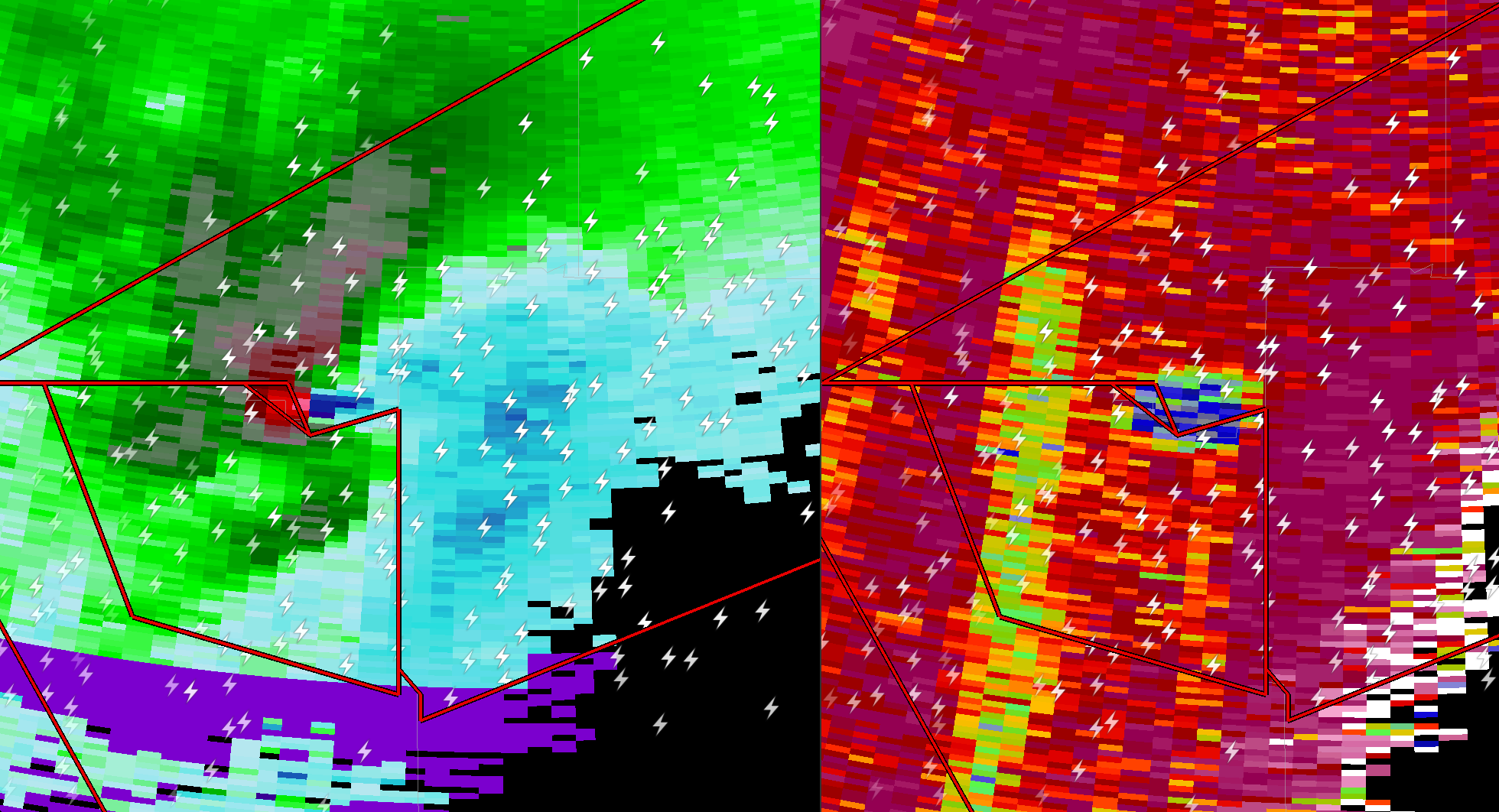
Quite the signature on the southern cell


-
1
-
-
The Meridian, MS on is 83/70 with a SE winds. KI agree the McComb cell is the best
-
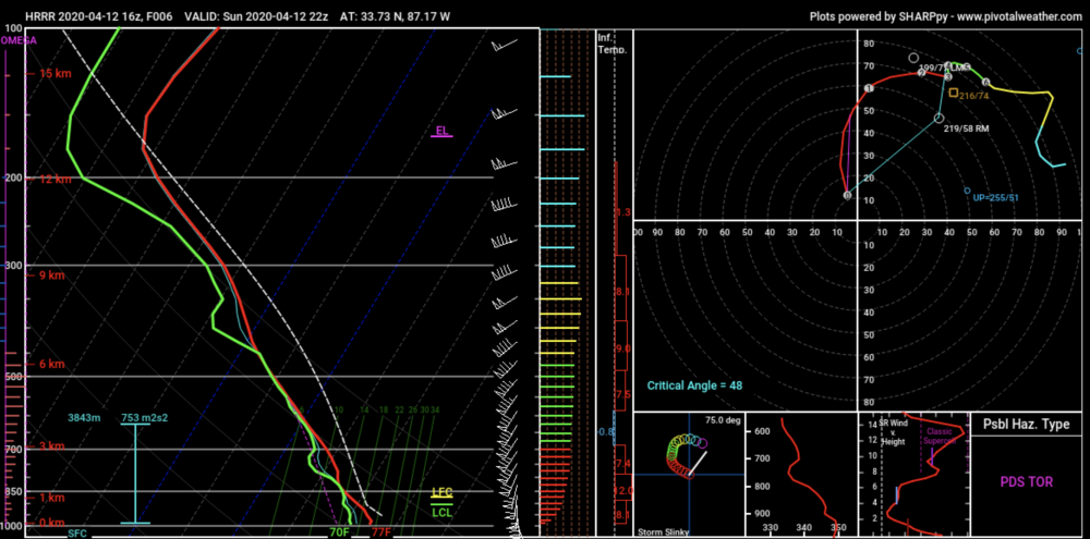
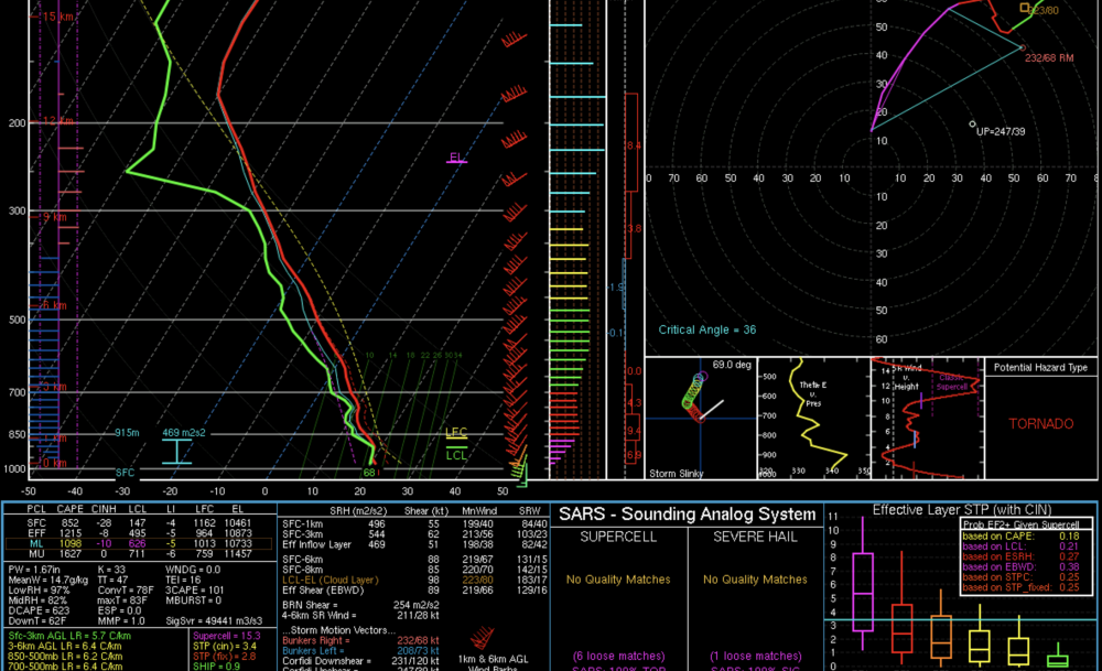
This sounding off the 16Z HRRR in NW of BHM is crazy. SCP of 32 SigTor at almost 10.
-
1
-
-
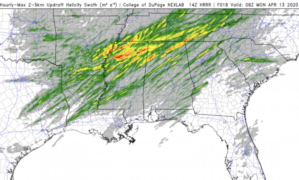
I bet SPC is pondering an upgrade to high. 14Z HRRR shows an increase in the number of significant UH tracks.
-
1
-
-
WOW
-
1
-
-
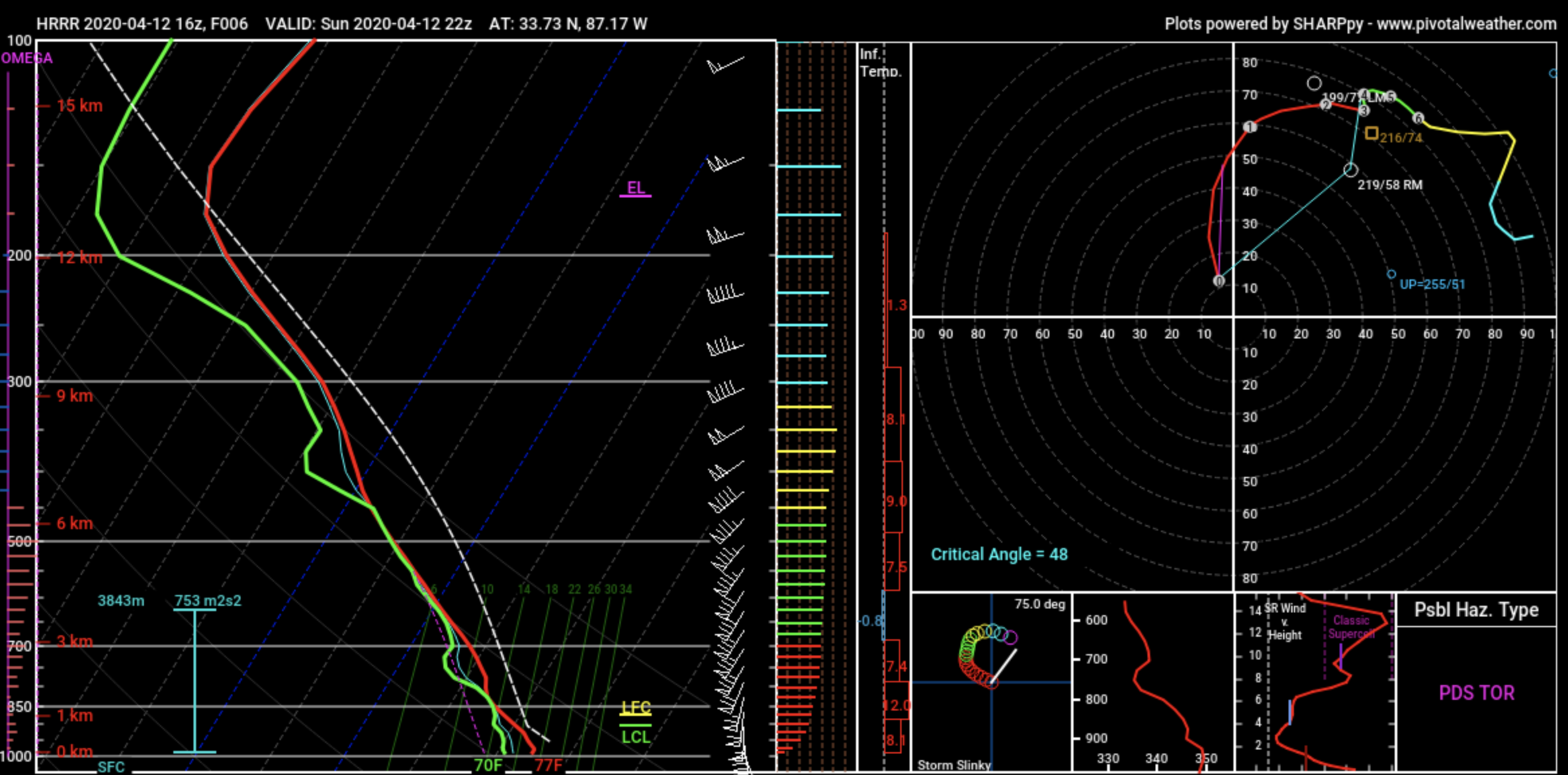
Getting very worried about a significant nocturnal damaging wind/QLCS tornado threat in the Atlanta area- this is the NAM-nest sounding which shows some pretty eye-popping numbers like storm motion 68 kts?!?!
-
1
-
-
5 minutes ago, mackerel_sky said:
Euro not even close to land, except Bermuda! Very suppressed run! Right where we want it 7 days out!?

It was never about the first wave, the only hope we had was for a second short wave digging in behind the lead low acting on the cold air left behind. The models are now pretty much unanimous in having no secondary wave at all, thus no snow.
-
1
-
-
This pattern bites since any significant snow is probably off the table, now that a lot of the flowers and buds have come out here if we get down to 20 or below Tues-Wed that will cause some damage.
-
Still about half of the EPS members show some snow in the ATL area, GEFS a bit more than half. I do think there will be a gulf wave along about Mar 4-5, question is how strong and of course where any snow bands might set up.
-
1
-


Major Hurricane Delta
in Tropical Headquarters
Posted
I agree this does not look anything like a borderline cat 5 on the sat pic. Odd storm.