

Cheeznado
-
Posts
2,077 -
Joined
-
Last visited
Content Type
Profiles
Blogs
Forums
American Weather
Media Demo
Store
Gallery
Posts posted by Cheeznado
-
-
It is so lame that my former employer (TWC) is putting totals on that map. I hated that when I was there and still do.
-
 3
3
-
-
The trend is the only thing worth looking at on the ICON and it is good. All else is noise. Lets not clog up the thread with every panel of the models quite yet, especially the lesser poorer performing ones.
-
6
-
 1
1
-
-
Only .03" here since Tuesday noon- all models had a big time fail in the Atlanta area, one of the biggest busts in a long time. Flash flood watch -yeah right.
-
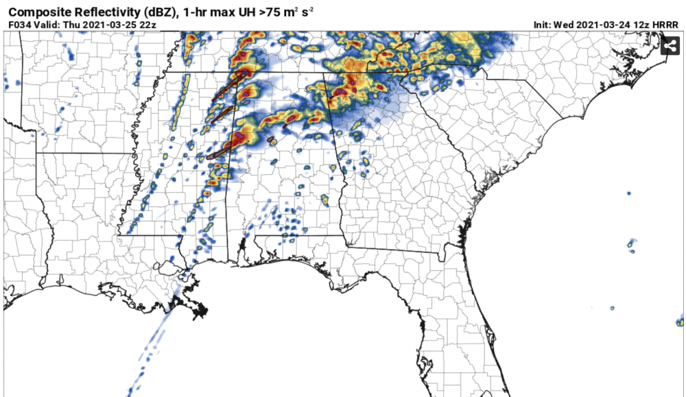
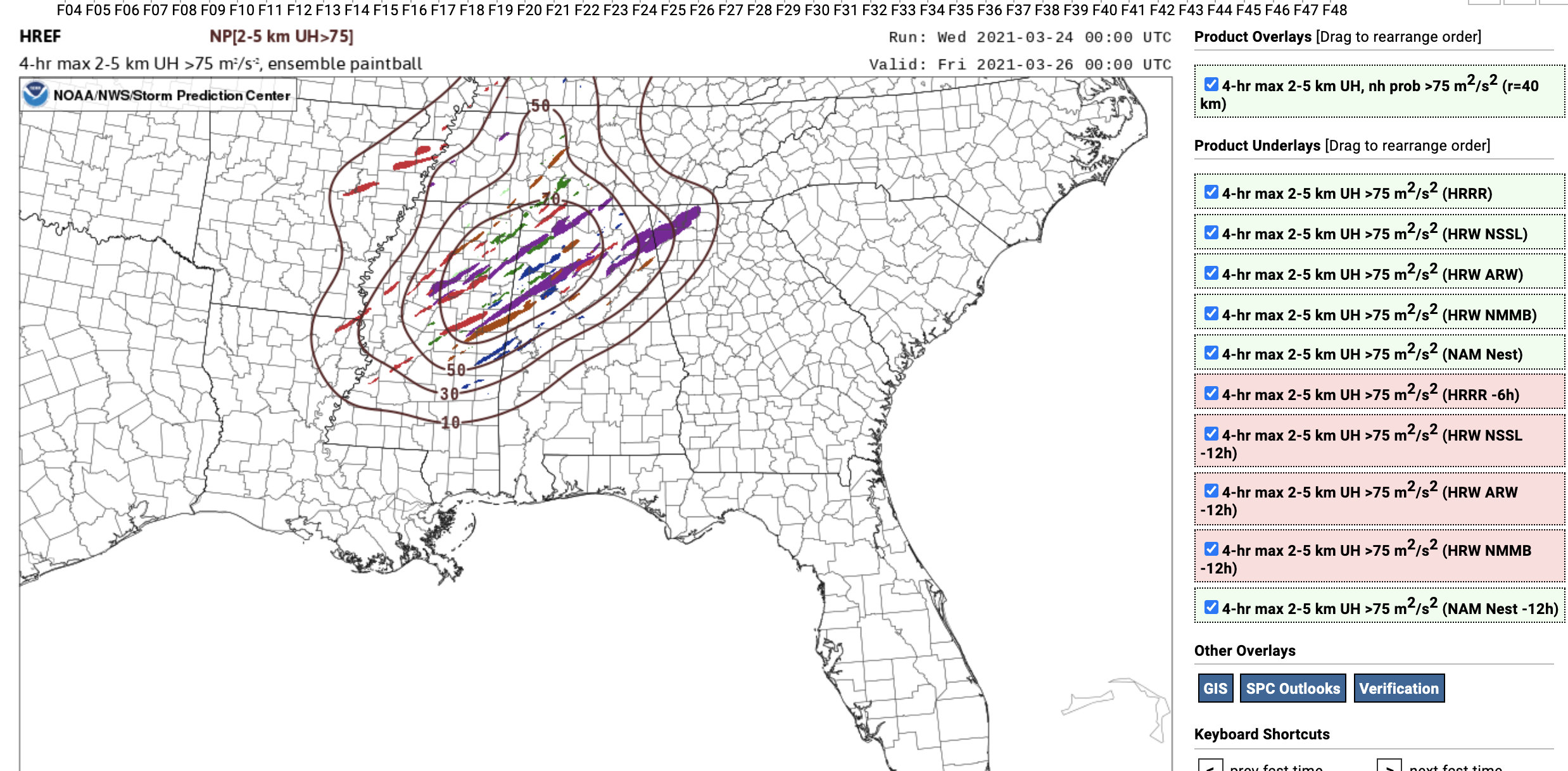
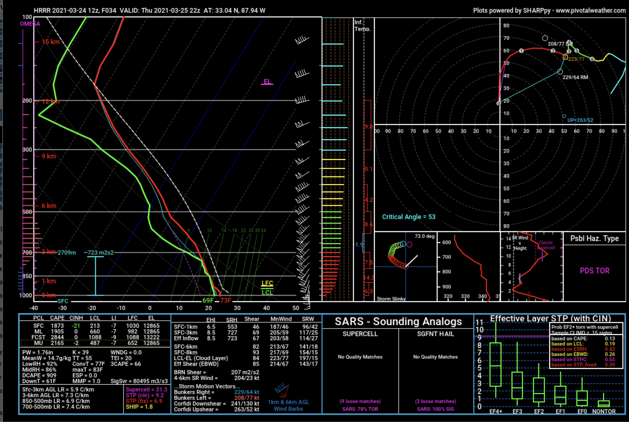
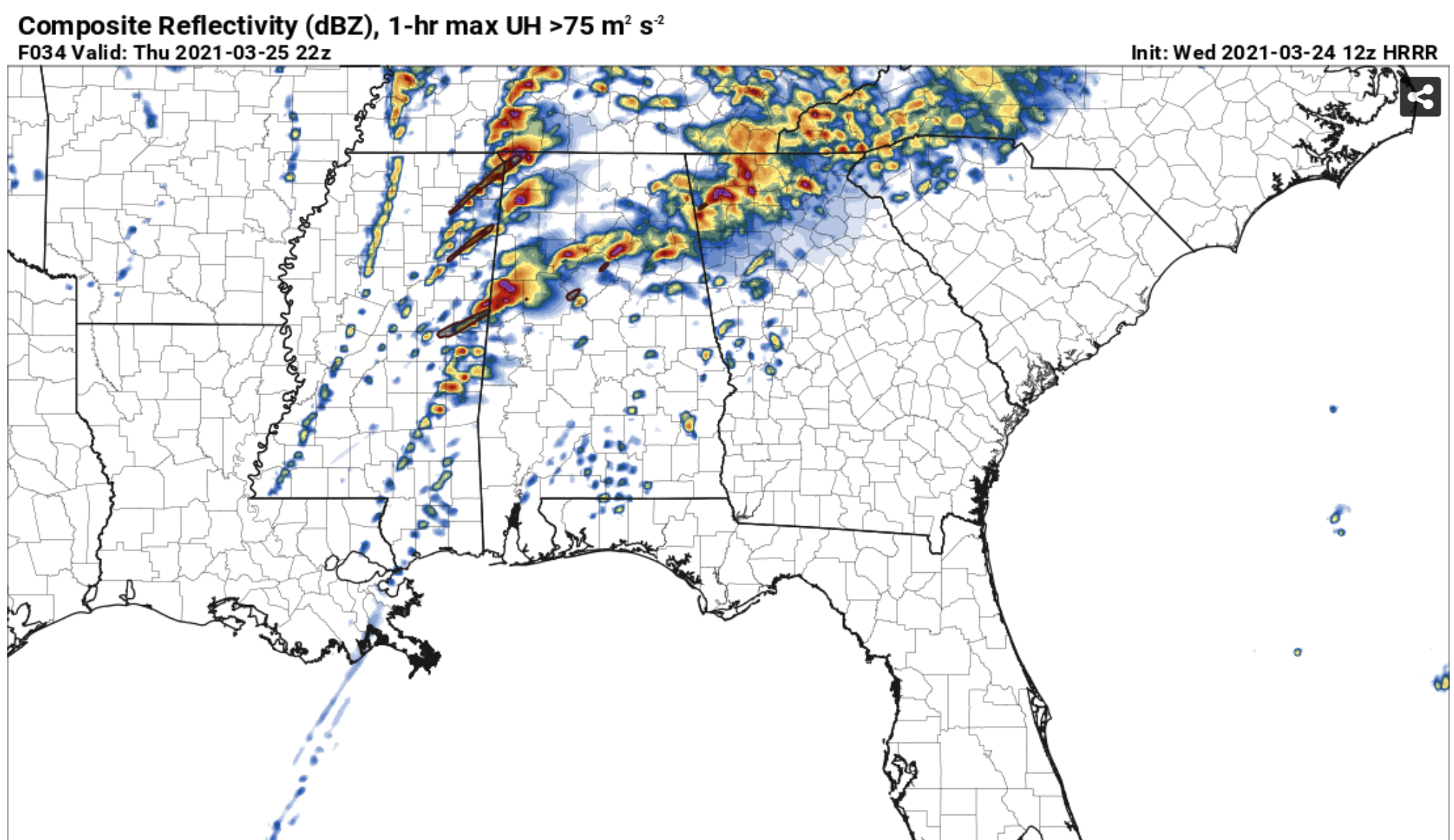
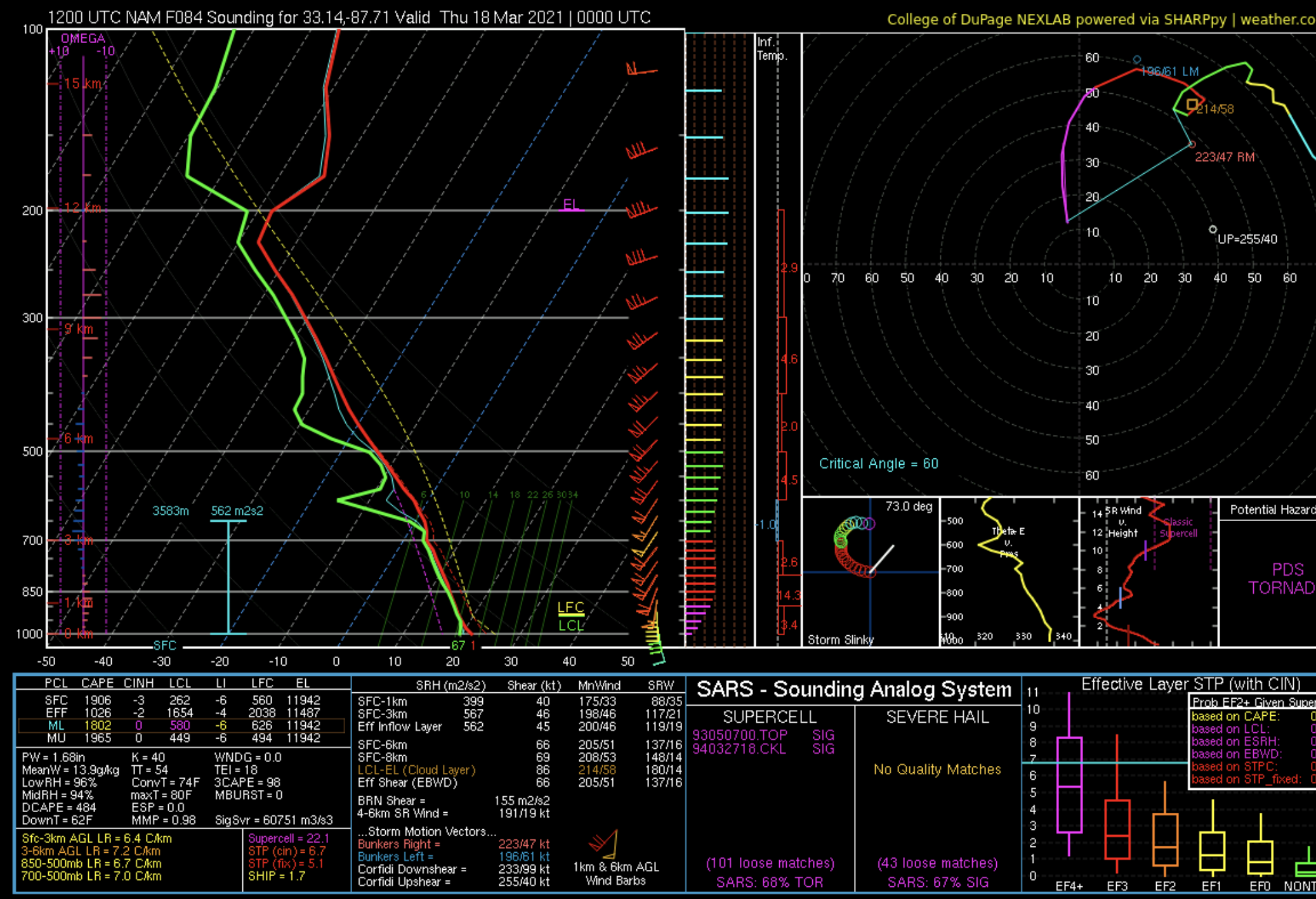
3KM NAM obviously the odd CAM out. What impresses me are the forecast incredibly high 0-1KM SRH values of AOA 500. That is at the level of the 2011 superoutbreak. Not saying this will be as bad, but still impressive.

-
1
-
 1
1
-
-
Just now, Indystorm said:
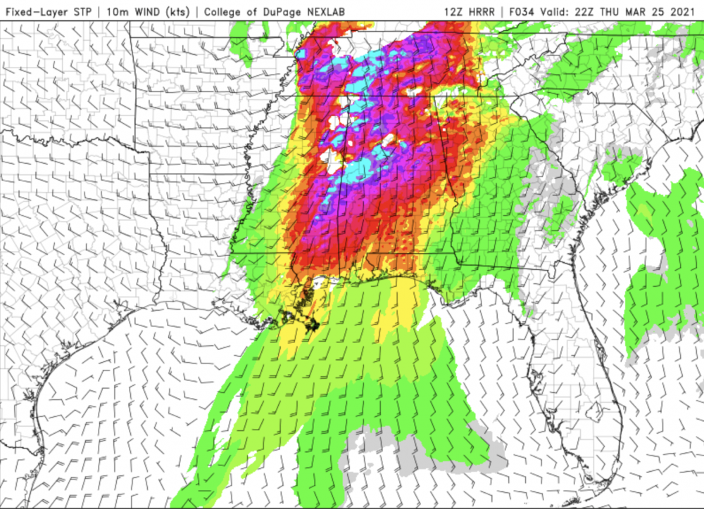
Yes the HRRR runs are consistently extreme from AL and MS north to the Ohio River Valley. How accurate were they a week ago for March 17?
By the time the event was 24-36 hours out the parameters were much less ominous than the ones for tomorrow.
-
Speechless. Hope not too many people die tomorrow.


-
 4
4
-
-
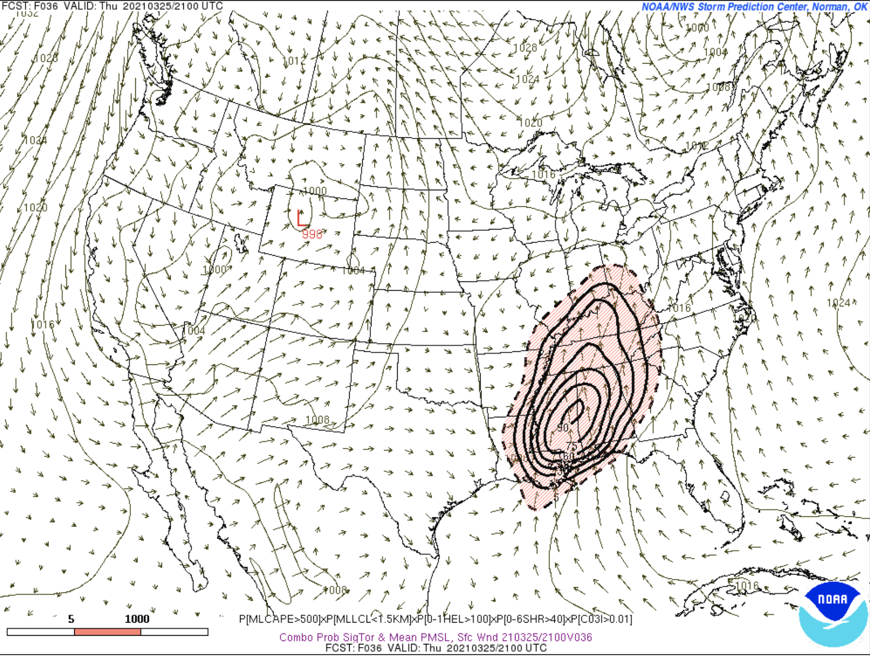
I think there is not one shred of a doubt that this this two day event was a colossal bust. (A good thing) This is NOT dissing SPC by any means, although at the time I was somewhat skeptical of the high risk upgrade. On Wednesday from what I can see of the damage reports, there was not one long track or violent tornado, and those were specifically mentioned in the watches and outlooks. Severe forecasting is hard, even for the experts at SPC.
-
1
-
-
I chased a really great supercell in Central Alabama yesterday west and SW of Selma. Best SE storm structure I have seen in my 41 years here. Go to https://www.facebook.com/cheeznadophoto
-
8
-
-
4 hours ago, jojo762 said:
As far as the high risk is concerned, it really comes down to the debate on IF you trust CAM UH track forecasts verbatim or if you have to extrapolate from the fact that they show convection ongoing in a high-end environment... For the most part I lean toward believing that an uncapped, high-end open warm sector environment with storms firing in it would yield several sig tors. Seems SPC agrees.
I agree also, UH tracks with relatively low-topped supercells can be misleading, Leaving shortly for my target of Meridian, MS to Tuscaloosa.
-
2
-
-
This NAM sounding from the KTCL area is about as textbook for tornadoes as you can get.

-
1
-
-
I have been looking at this for a few days now, will probably be my first storm chase in over a year.
-
Sleeting here.
-
1
-
-
Holy schmoley that GEFS- 3.7" here? I doubt it but that increases the odds of at least a bit of accumulation in the ATL area. In any even I plan to drive to the NW somewhere even if we get not that much in my backyard.
EDIT:SREF is also on the at least some accumulation bandwagon. This is for the airport.
-
1
-
-
Despite the poor trend of the latest Op GFS, the ensembles hold out some hope for snow here. Lets wait to see what the Euro does before sticking a fork in the chances.

-
2
-
-
You go have to give the GFS points for consistency with measurable snow in north GA including Atlanta -let's just hope the Euro starts trending stronger/slower. The short wave in question is still in the Pacific so until that comes onshore in 36 hours or so we will still not know much.
-
3
-
-
2 minutes ago, Moderately Unstable said:
It appears that the issue is with the feed itself, goes 16 meso 1, rather than with the storm floater. Hence not an issue with where you get the feed, it is the feed. On a creepy note it appears to be centered on my location now. HIIIIIIIIIIIIIIII.
Yes, another plane will be arriving soon. They post the plan of day you know. Search Google. Nhc plan of the day. They say when they're launching the planes.
What a beautiful storm structure. Stuff like this can hold my attention for hours.
I realize that, but there have been some recent issues with planes turning around etc so keeping my fingers crossed.
-
Too bad the current recon plane left, hopefully another one will get in there before landfall.
-
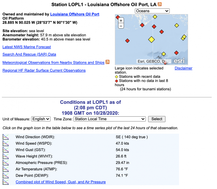
Wow, 26 ft seas just south of the mouth of the MS...
-
Big question is how much strength it loses as it will spend a fair amount over the Yucatan, both the HWRF and HMON have it back down to a TS and never really bring it back to a hurricane.
-
1
-
-
Last recon center reformed farther to the south closer to being underneath the deep convection.
Also the Euro track is weaker and farther west than most of the other models.
-
1
-
-
My take: something develops in the central Caribbean in about 5-7 days, strength unknown, with a very good chance it goes east of FL and the rest of the US coast.
-
Both the HWRF and HMON have it too strong by 15-20 mb by 00Z. Do not see any signs of RI right now so by later tonight that discrepancy may get larger.
-
I hope a lot of the model sites take advantage of this. If so, I will not be using my pay service anymore since the Euro data is the main reason I paid any money.
-
2
-
-
I agree this does not look anything like a borderline cat 5 on the sat pic. Odd storm.


Jan 15-16 Winter Storm
in Southeastern States
Posted
Lousy run for Atlanta but I have a place to stay in the GA mountains so a road trip may be in order. Let's see what the Euro does.