

Cheeznado
-
Posts
2,077 -
Joined
-
Last visited
Content Type
Profiles
Blogs
Forums
American Weather
Media Demo
Store
Gallery
Posts posted by Cheeznado
-
-
984 now, HWRF does not have it that strong until 06Z Wed, Hmmmm.
-
9 minutes ago, tiger_deF said:
Sure looks like an eye is trying to pop out, likely just a warm core feature
Way too weak for any real eye to be present. Regarding landfall intensity I think that fairly rapid weakening right at the coast is likely due to cooler water and shear, it all depends on how strong it gets in the central Gulf. I noticed that the HWRF backed off of the intensity quite a bit with the 06Z run.
-
This GFS storm is not the area that NHC is watching right now- that system, if it develops, would probably stay down by the Yucatan or Bay of Campeche. The second one originates in the southern Caribbean.
-
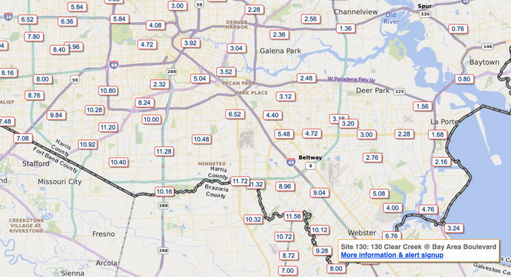
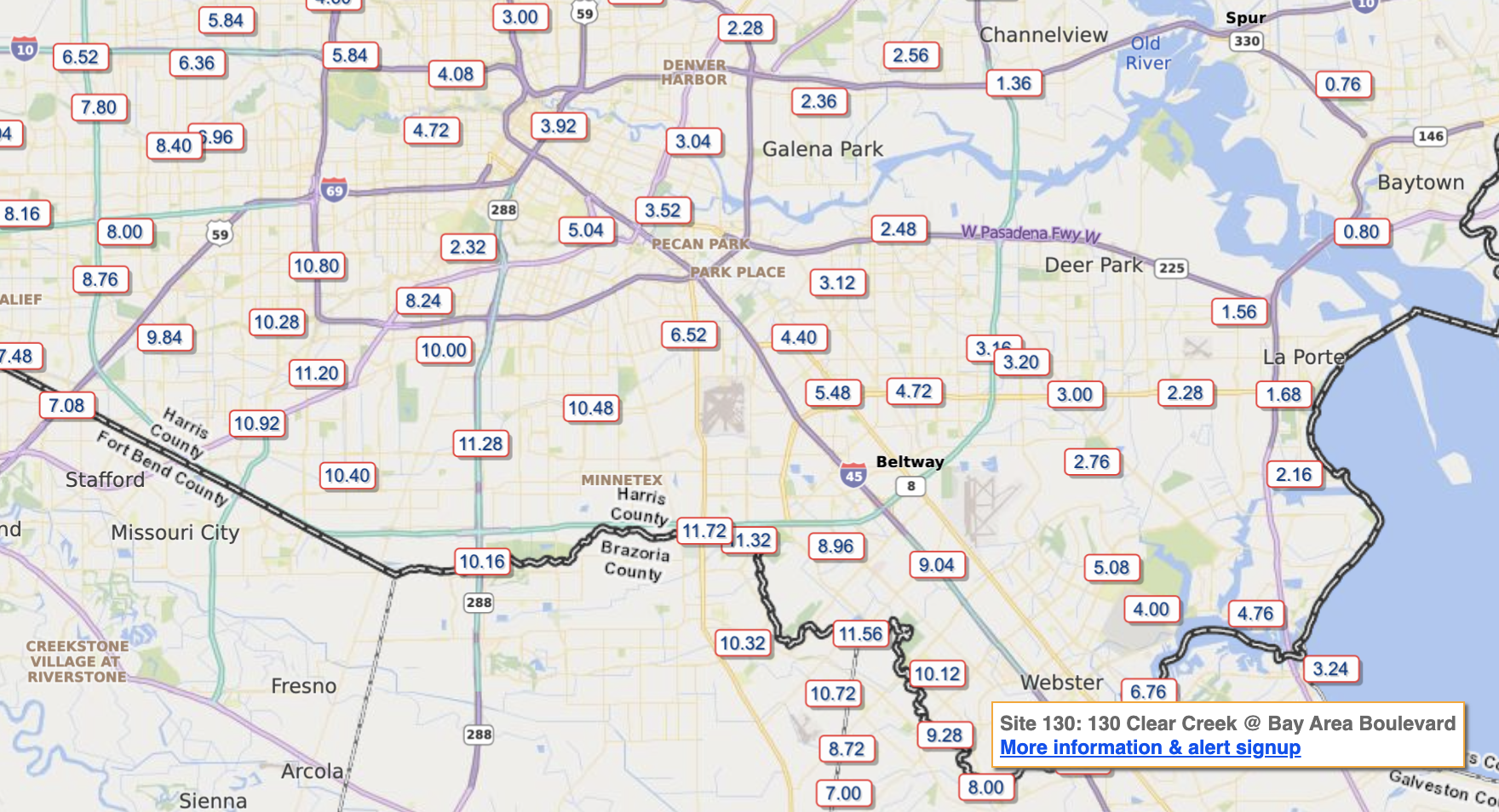
Radar estimates borne out by gauges- up to nearly 12"
-
11 minutes ago, Maestrobjwa said:
Uh...can we even say that yet? Isn't this thing supposed to be meandering for several days before landfall?
I said iffy, that is still very possible but there are some caveats. EDIT: well, now there is a burst of convection near the center. So who knows.
-
Center completely exposed, the latest HRRR has it too strong right now and even with that it weakens it to 40kts at landfall. So even the big flood type scenario is looking iffy right now.
-
 1
1
-
-
4.6" here total so far, about what I was expecting.
-
 1
1
-
-
New Euro stalls it on the lower TX coast, then moves it NE to the LA coast. This is similar to what the GEFS is hinting at. That would be a trip...
-
A Central America hit in any case....
-
That shear is forecast to decrease and retreat north as the UT weakens and retrogrades. The question is where will the storm be at that time- the weaker it gets the more westward it will go and get sheared even more but if it can stay stronger a bit longer it may go on a more northerly path and stay in a lighter shear area. Not saying it will be that big of a deal but it may not totally be "ripped to shreds" either.
-
1
-
-
Where NHC says the center is the plane found nothing even close to a circulation. I think maybe they jumped the gun in calling it a TD.
-
1
-
-
I find it rather interesting that despite the forecasts of a possible record # of storms it is awfully quiet right now (not counting that wimpy Josephine and the who-cares 96L off the Carolinas)- and none of the global models have much of anything through the end of the month- this is with the peak of the season approaching.
-
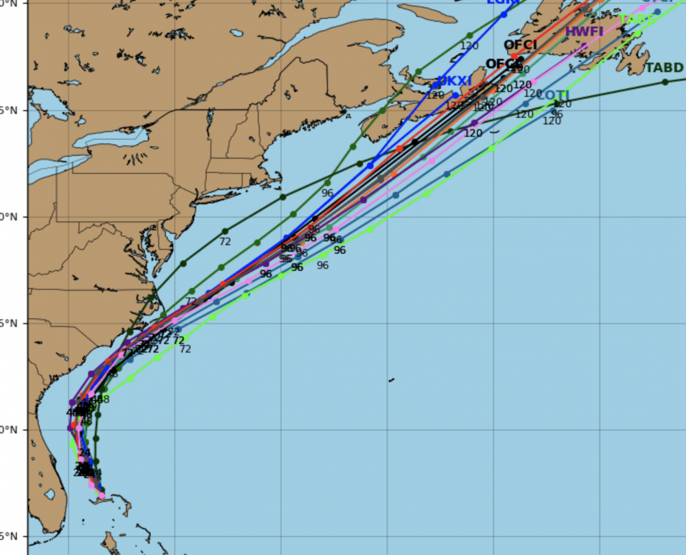
Latest synoptic models actually have this making landfall in the OuterBanks...
-
1
-
-
Overall this was a pretty big bust tornado wise, really only 5 separate reports so far. There will be a few more added after surveys but in general the large 15% hatched did not verify. Which is good news.
-
2
-
-
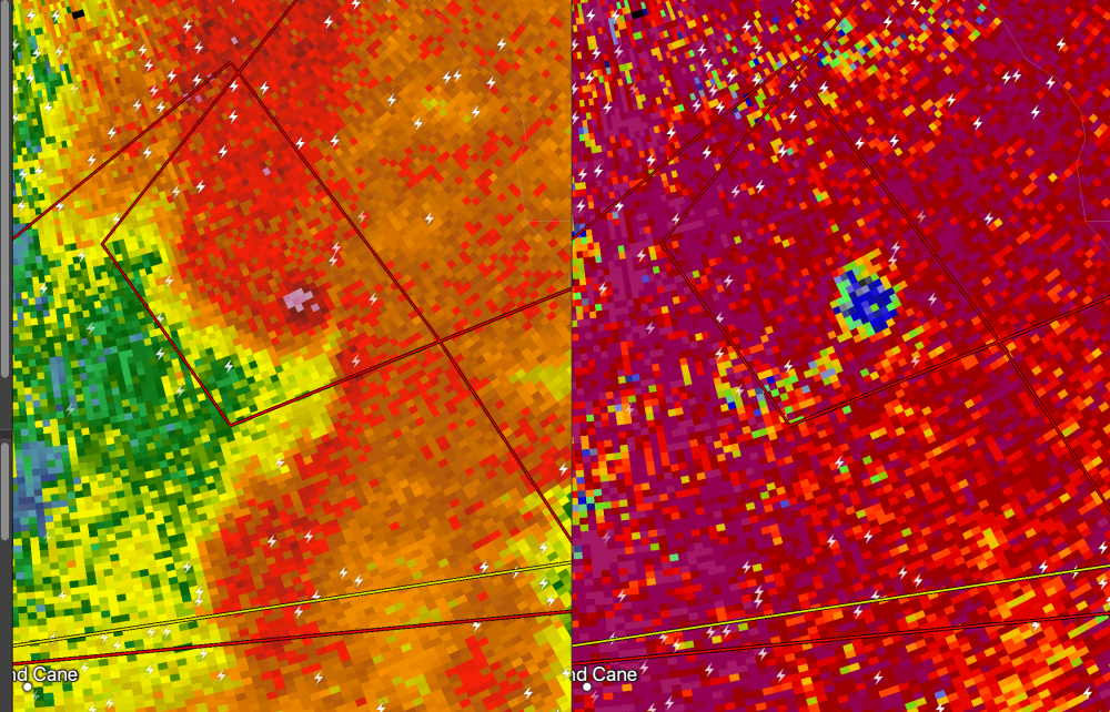
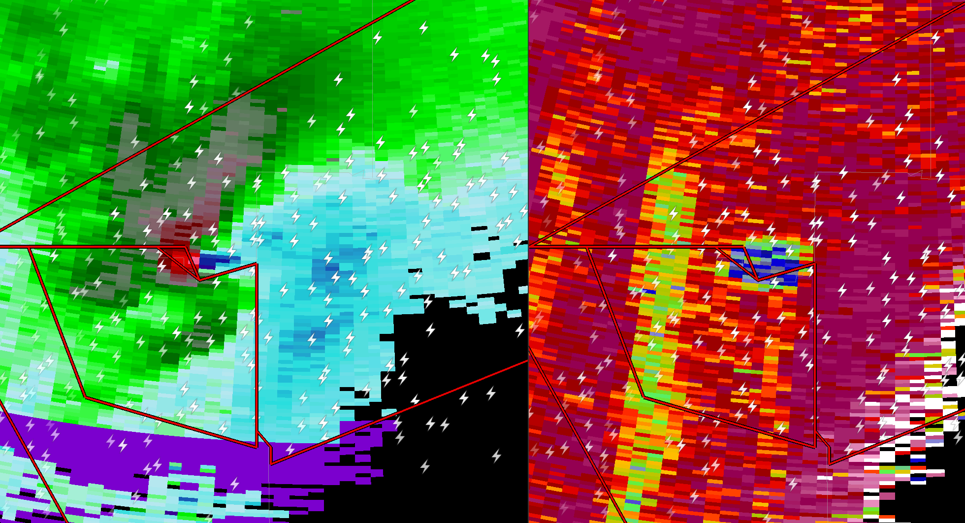
Quite the signature on the southern cell


-
1
-
-
The Meridian, MS on is 83/70 with a SE winds. KI agree the McComb cell is the best
-
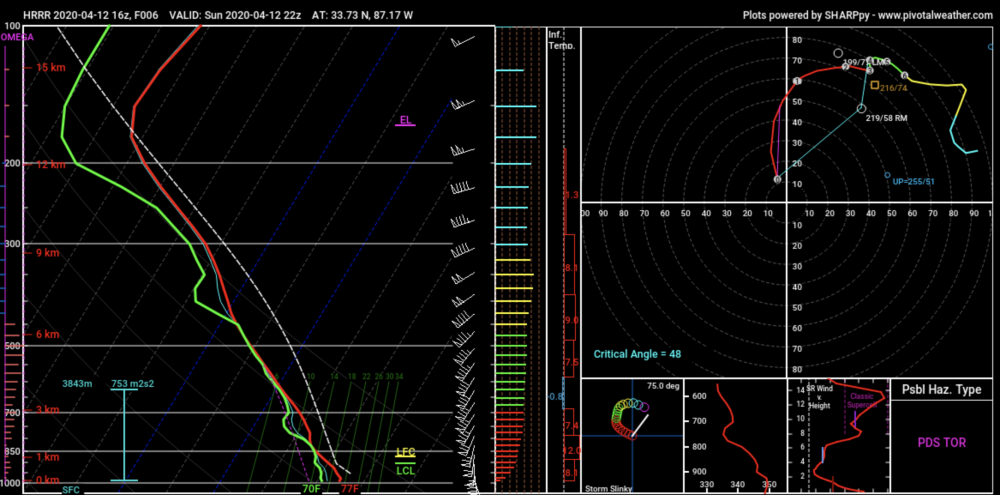
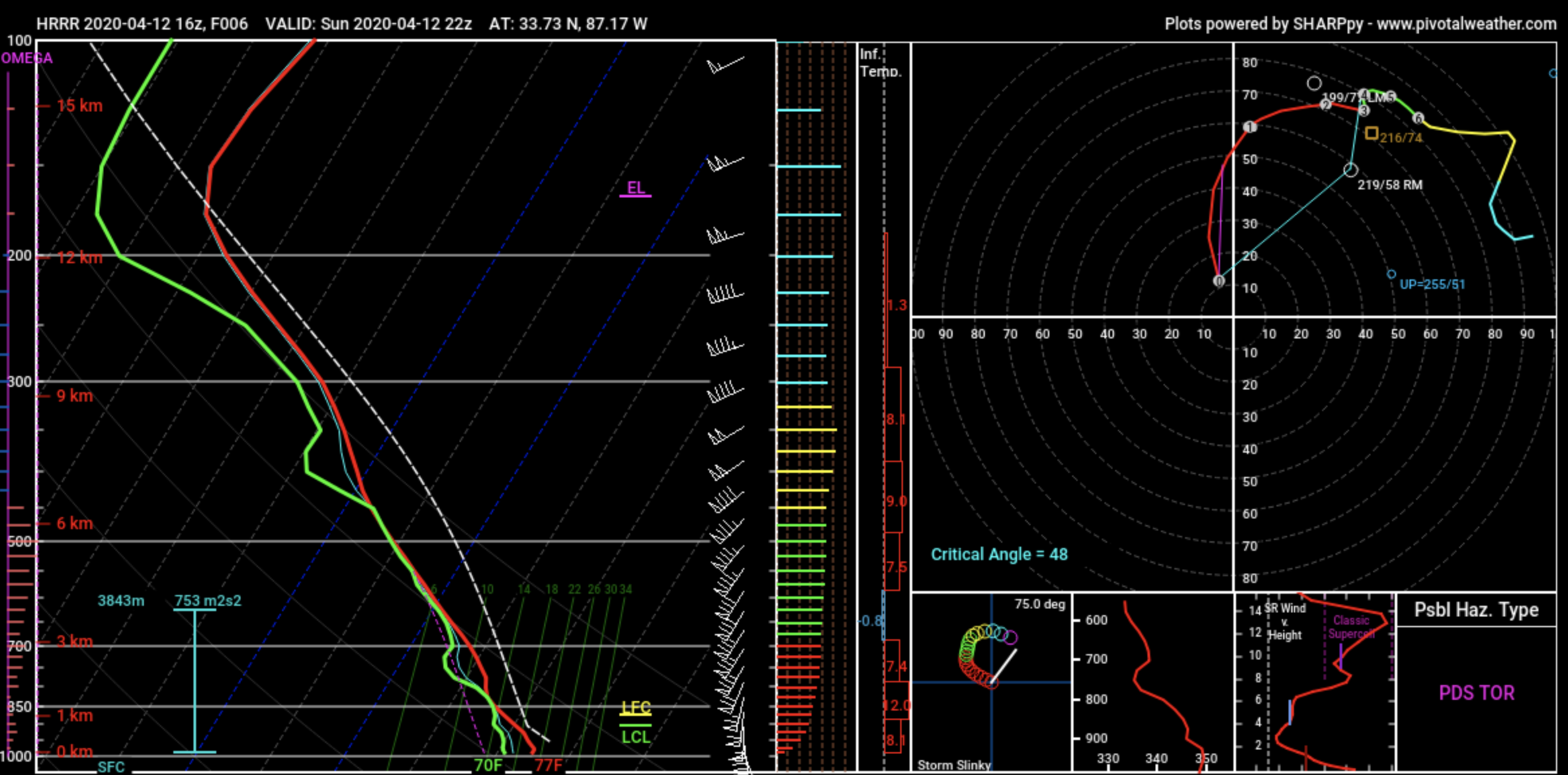
This sounding off the 16Z HRRR in NW of BHM is crazy. SCP of 32 SigTor at almost 10.
-
1
-
-
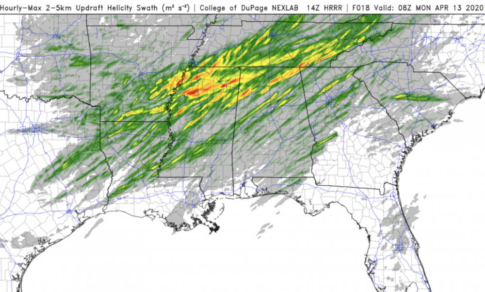
I bet SPC is pondering an upgrade to high. 14Z HRRR shows an increase in the number of significant UH tracks.
-
1
-
-
WOW
-
1
-
-
Getting very worried about a significant nocturnal damaging wind/QLCS tornado threat in the Atlanta area- this is the NAM-nest sounding which shows some pretty eye-popping numbers like storm motion 68 kts?!?!
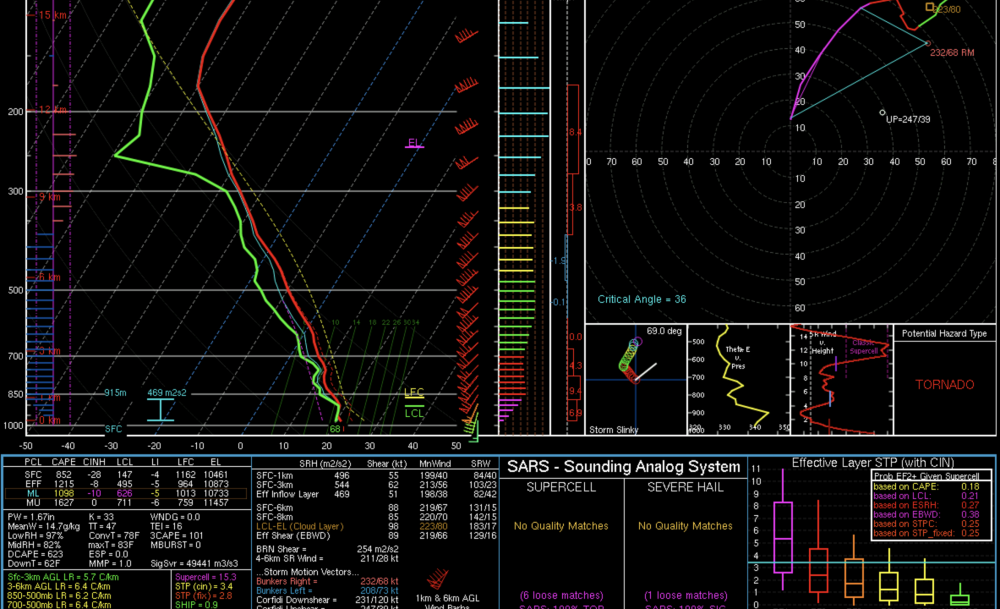
-
1
-
-
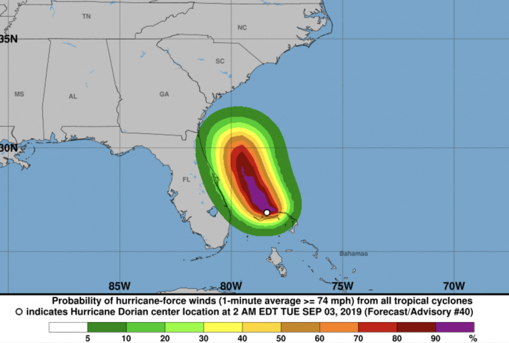
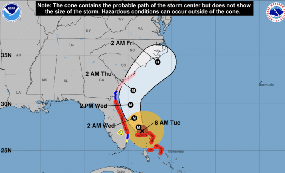
At 11, they STILL have the warnings even due W and SW of where the center is now. Their own definition of what a hurricane warning means:
A Hurricane Warning means that hurricane conditions are expected
somewhere within the warning area.  Preparations to protect life and
property should be rushed to completion.
However, again their own product- the hurricane wind probabilities- show no more than a 20-30% chance of 74mph winds on the FL coast, is a 25% chance "expected"? Of course not.
Let's use an an analogy from another type of forecast. Would it be acceptable for a NWS office, say Boston, to issue a winter storm warning, but the next set of models have no snow at all so they remove the chance of snow from the forecast but keep the warning in place?
-
 1
1
-
-
Yesterday you can make an argument. But right now the warnings and watches in FL and GA are not even their own forecast cone!
-
1
-
1
-
-
This will be a controversial opinion but so what, I am retired now so bombs away.
I have been in the forecasting game for over 35 years, I was at TWC for over 30 and have been involved with hurricane forecasting for all of that time period. First off let me say that the mets at NHC work incredibly hard and are dedicated and professional public servants to which the nation owes a great debt.
However, one tendency that I have noted since way back in the early 80s is their philosophy of "even if the odds are incredibly against a particular storm suddenly deviating from it's forecasted path, we must always err on the side of caution" and deliberately overdo watches/warnings even we know that chances of the storm affecting those areas are very small. Case in point is the current situation with Dorian. The model clustering is about as tight as it ever gets, and the official forecast is following that closely. The winds on this and most hurricanes are weaker on the west side of the storm, the Cman station on the west tip of Grand Bahama Island never had a sustained wind of hurricane force, in fact the highest was only 54 kts, even though this location is much closer to Dorian than Florida is ever going to be. Right now the highest wind gust anywhere in the FL coast right now is about 30 mph, and even if the storm does go NNW as forecast, why would any location in FL or for that matter GA have winds remotely close to hurricane force in gusts, much less sustained? This type of extreme caution is certain to lead to even more public skepticism over future hurricane forecasts and evacuation orders which would result in people staying put when they really should evacuate. My totally worthless and biased opinion....
-
3
-
1
-
-
The "traditional" hurricane models are sure saying that Dorian stays well offshore even in NC, and with still no west component evident on sat or radar, I have a feeling that this will verify. There has been a clear west bias with synoptic models and the HWRF all along. One thing is for certain IMO is that FL and GA are in the clear mostly, the hurricane watches/warnings there are overdone and should be cancelled.
-
1
-
 1
1
-


Major Hurricane Delta
in Tropical Headquarters
Posted
I think think the RI has paused for at least a little while based on the last few fixes and the fact the eye has not gotten any clearer. This is a very small storm compared to Gilbert and Wilma which may be a factor for now.