

Cheeznado
-
Posts
2,077 -
Joined
-
Last visited
Content Type
Profiles
Blogs
Forums
American Weather
Media Demo
Store
Gallery
Posts posted by Cheeznado
-
-
12Z GFS is a tad faster but otherwise very similar to the 06Z run.
-
On a side note, what the heck is wrong with the recon planes? Looks like at least two had to abort, no fixes now for quite a while...C'mon AF, get your sh%it together...
-
New GFS has shifted right a bit off FL but then it still hits NC, but much weaker.
-
Josh Morgerman, crazy person, is right in the path on Great Abaco Island. https://twitter.com/iCyclone
-
The Euro has no US landfall.
-
Euro misses FL altogether LOL.
-
 1
1
-
-
12Z GFS big time right shift....
-
FWIW the latest HWRF has it up to almost a cat 5....
-
Euro second landfall FL panhandle Thursday.
-
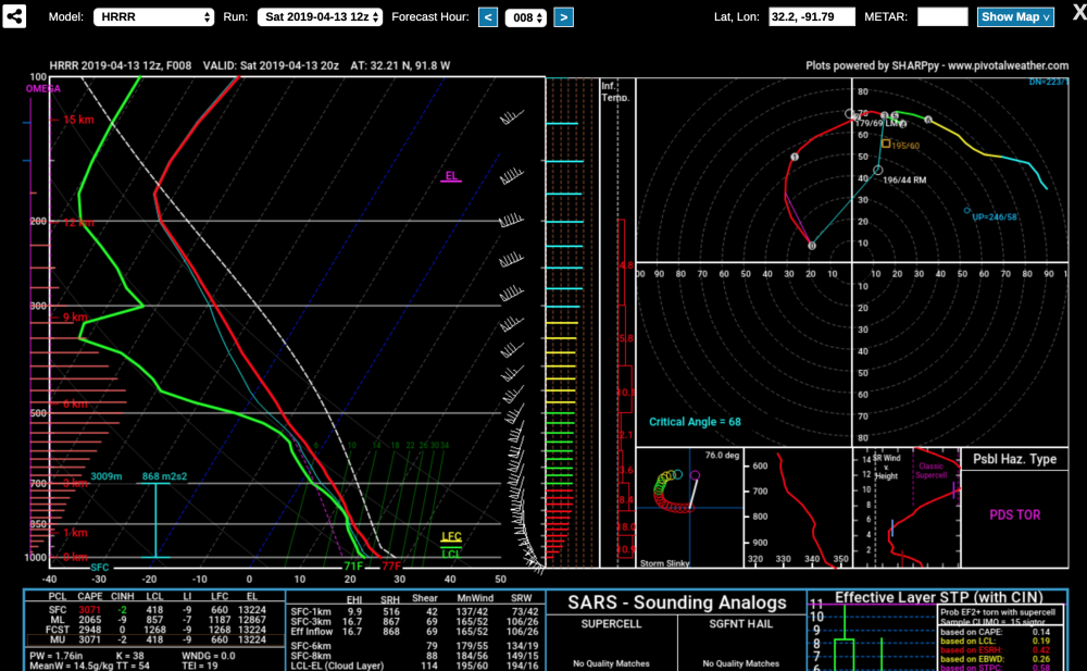
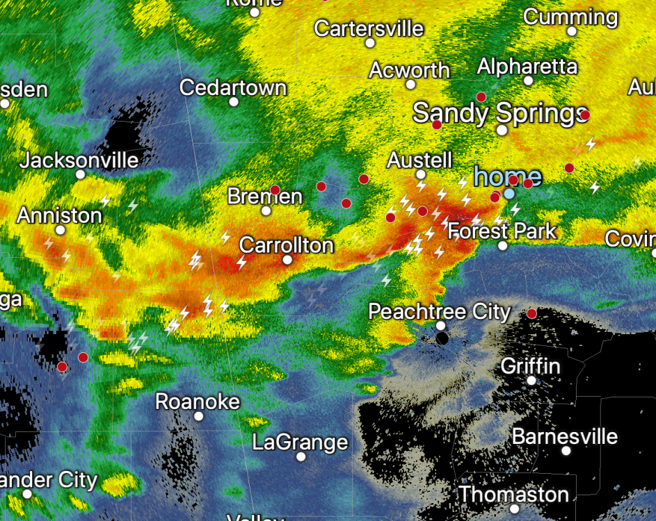
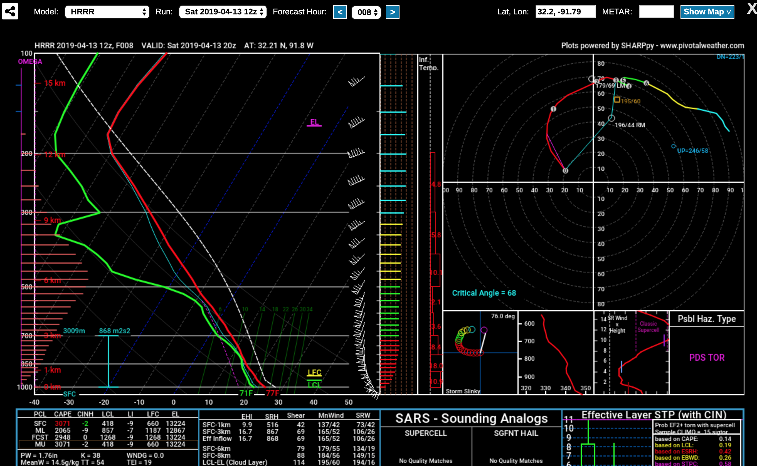
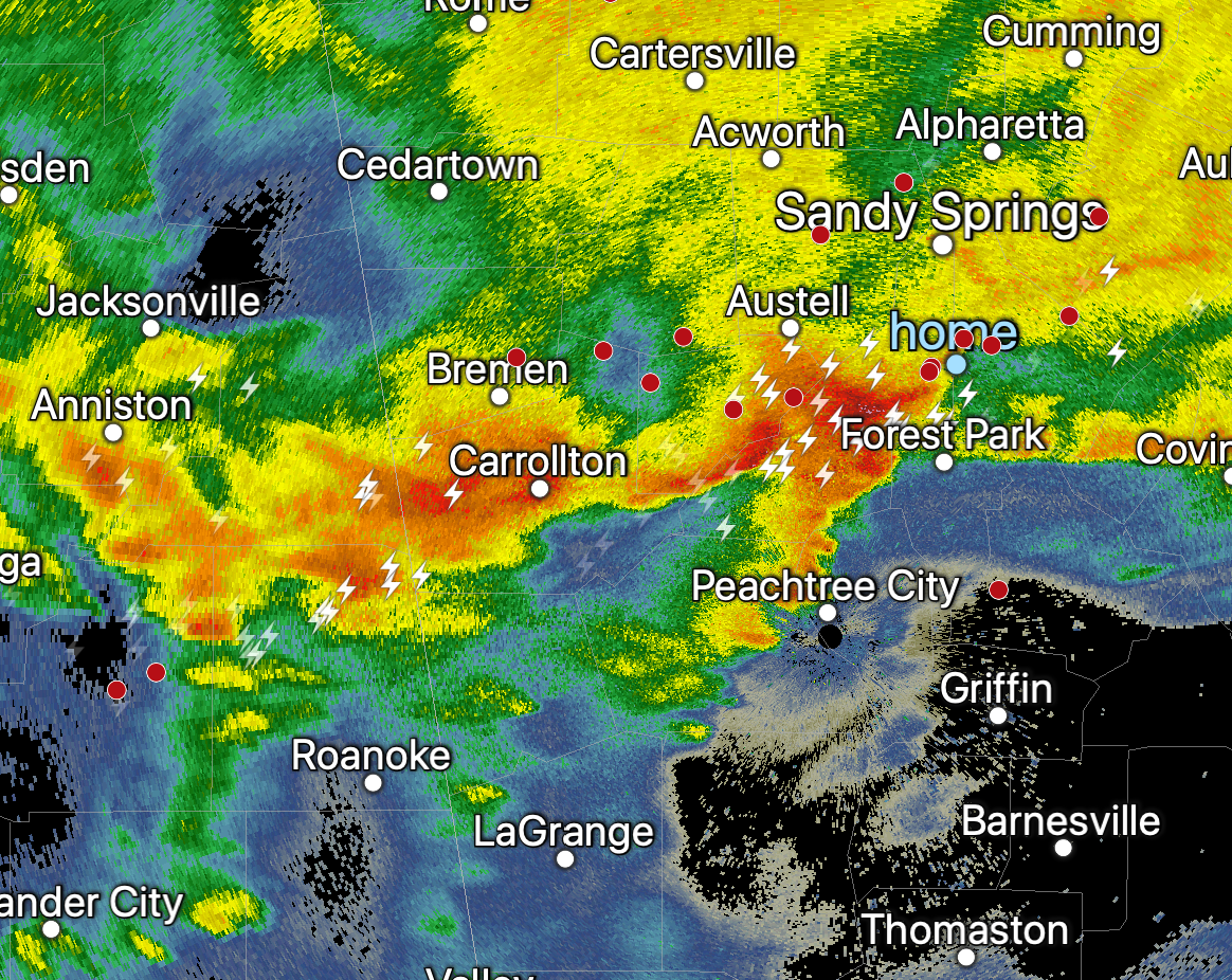
The forecast soundings for the LA area are insane, could be a few really nasty and unfortunately deadly tornadoes.. Tomorrow here in Atlanta we will get round one with the usual unfavorable timing of 15-18Z, then the cold front will re-fire but will there be enough instability for really significant severe, since the dynamics/shear are still very strong.
-
Flizzard in Atlanta!!! At least it will not be 100% snow free....
-
5 minutes ago, mackerel_sky said:
Euro not even close to land, except Bermuda! Very suppressed run! Right where we want it 7 days out!?

It was never about the first wave, the only hope we had was for a second short wave digging in behind the lead low acting on the cold air left behind. The models are now pretty much unanimous in having no secondary wave at all, thus no snow.
-
 1
1
-
-
This pattern bites since any significant snow is probably off the table, now that a lot of the flowers and buds have come out here if we get down to 20 or below Tues-Wed that will cause some damage.
-
Still about half of the EPS members show some snow in the ATL area, GEFS a bit more than half. I do think there will be a gulf wave along about Mar 4-5, question is how strong and of course where any snow bands might set up.
-
1
-
-
The last few runs of the GEFS have had about half of the members with snow in north GA at about 240, 1/3 of the EPS have small amounts. So it is on my radar barely but given how lousy this winter has been so far not optimistic- still just basically waiting for more thunderstorms.
-
Maybe the best winter elevated t-storm I have seen here in 36 years. A ton of close CG strikes. This happens in the Plains a lot but very rare here.
-
1
-
-
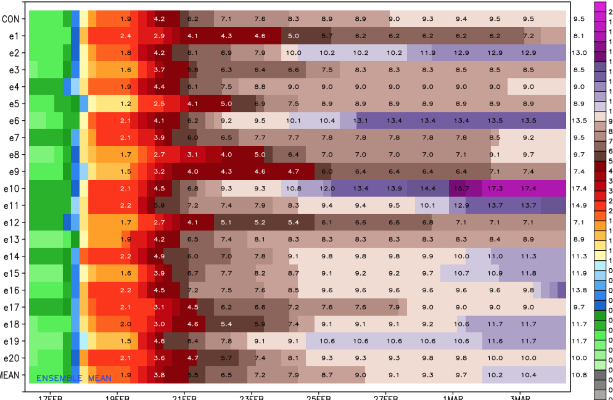
I know anything other than frozen precip gets crickets on this group, but check out these 15 day precip totals for Blairsville, GA from the 06Z GEFS. Could be epic flooding.....

-
This forum should be renamed American Winter Weather- it is amazing how posts dry up almost completely once the threat of snow/ice is over. I love snow as much as the next person but am interested in all types of weather....
-
4
-
-
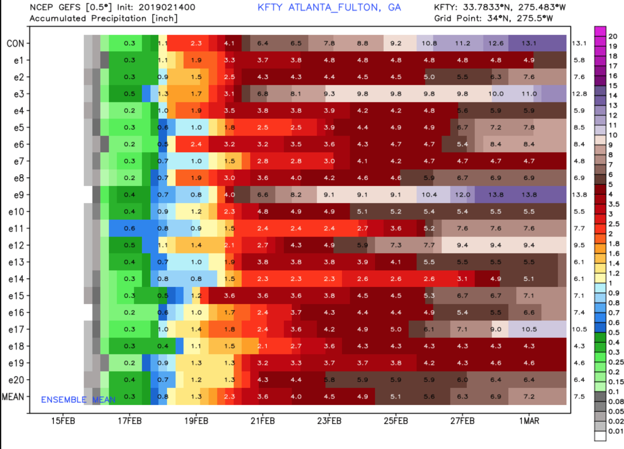
06Z 2/14/2019 guidance from the ICON and GFS suggest the heaviest axis of rain will be north of Atlanta. 0Z CMC was also north of Atlanta with the heaviest precip. This seems to suggest the affects on Atlanta will be marginal. Would you agree? Also, what mechanisms would be in play to drop the axis south? It seems to me that the SE ridge is depicted as strengthening through day 10. Wouldn't this push the best lift north as well? I'm thinking mild to warm with maybe up to an 1" of rain for Atlanta would be realistic in that scenario.
I disagree, GEFS, EPS have been very consistent with at least 5" for the whole event. Would be extremely surprised if ATL only got an inch.
.-
1
-
-
Since winter is probably over here, the focus turns to heavy rain, check out some of these GEFS totals here- could be historic flooding if we really get 10-13" of rain like some of the members have.....

-
2
-
-
Looks like a better chance of thunderstorms and even some severe weather in the south next week than snow......
-
 1
1
-
-
Over in AL no reports of accumulation to speak of, HRRR and 3km NAM have no snow here at all....BUST! I say let's go directly to severe weather season. This could easily be the first year in a long time where there was not even one flake of snow IMBY.
-
1
-
-
Based on a pretty unified EPS and GEFS consensus of a western trough and SE ridge after this week, and given the fact that since 1930 there have only been five 1" or greater snow events in Atlanta past Feb 15, I am close to saying wait till next year here for snow after the Tues. event.
-
1
-
 1
1
-
-
00Z NAM and 3KM both have basically no accumulations in Atlanta but the 21Z SREF amounts went up a bit. So not changing my .5-1" forecast yet but I will say that since all models have at least some sunshine by Tuesday afternoon the chance of any major road problems in the metro have decreased.
Dorian
in Southeastern States
Posted
According to the Recon the pressure went up about 20mb during the ERC. Also, the new Euro is a tad farther southeast offshore the Carolinas.