

BlizzardNole
-
Posts
2,632 -
Joined
-
Last visited
Content Type
Profiles
Blogs
Forums
American Weather
Media Demo
Store
Gallery
Posts posted by BlizzardNole
-
-
From that Wiki link at the top: "On 5 September, flooding in Thessaly, Greece, killed at least one person.[8] On the same day, the village of Zagora received 1,092 millimetres (43.0 in) of rain, 55 times more than the country's average rainfall for the same month."
Holy crap that is Houston (Harvey) numbers!
-
 1
1
-
-
2.6 from the heavy thunderstorms last night for an incredible 5.6 for the month (all since Friday). The ground no longer feels like concrete and brown grass is greening up.
OT: Lee looking more of a problem for Boston area? FSU vs. BC at noon on Saturday looking a little problematic...
-
2
-
-
2.1 inches from that heavy thunderstorm and another one rolling in! Already more rain in 5 days than practically the whole summer combined
-
6
-
-
Now HEAVY rain with frequent lightning and thunder. Desert rats unite! We are finally getting ours
-
6
-
-
Getting a nice thundershower to add to the ground moisture as we head into a gorgeous stretch of late summer weather. Some nice lightning and rolling thunder too.
-
2
-
-
Another 0.5 last night for a total of 3.0 since Thursday. So needed
-
2
-
-
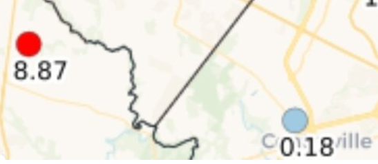
That is crazy seeing 8.87 and just a short distance away near Centerville 0.18
-
2
-
-
I hope areas that have missed out can cash in today then we sail into several days of luscious fall weather later this week
-
1
-
-
I am stunned -- 2 inches so far which is more than the whole month of August
-
8
-
-
Finally for the first time since the first week of August, it is POURING here! And looks like more to the south moving in. S to N is key for my area; W to E or NW to SE moving stuff almost always fails with the downsloping. S to N has no obstacles and it is ripping
Edit: OK Leesburg you're up!
-
2
-
-
1 minute ago, SnowenOutThere said:
Just had the most intense thunderstorm of the season come through, heavy rain/wind with a pretty good amount of hail.

Hey SNOWEN that pic turned out looking like when rain is changing to snow!
-
1
-
-
Our daughter in College Park said a lightning bolt out of nowhere hit real close to her apartment with sun shining. I looked at Radarscope and the bolt was indicated right where she is with the thunderstorm 5-7 miles away. That's what can make lightning dangerous!
Based on radar, looks like everything is east today so I'm glad I watered the gardens this morning. Near shutout continues
-
3
-
-
Woke up to a loud thunderstorm just after 3 am and thought finally?! Looked at radar and.....NOPE. To the east this time around Laytonsville area. I did get 0.2 from storms that mostly missed east earlier last evening. The sprinklers are running this morning as that piddly 0.2 will be all we get here
-
Managed 0.2 which is actually a decent rain for this extreme desert microclimate. It's the first measurable rain since August 7 and probably the last for a long time.
The sprinkler system will run tomorrow morning as scheduled. I let the grass go and haven't mowed in weeks
-
Basically nothing as everything trained just to the west earlier. Now it's happening again just to the east! My gawd this place is sick. I'm calling it now -- it will not rain at all in this godforsaken microdesert over the next several days. NONE
-
 1
1
-
-
Literally a WALL keeping everything training just west. I bet my area gets a total shut out all the way through Monday
-
Elongated storm skirting by just to my west clinging to the high terrain with just sprinkles. I think the whole thing is gonna miss. Painful to watch
-
That cell heading into Washington County looks nasty on radar
-
Currently 87/71. Definitely feels more humid
That GFS rainfall map looks good but I'll have to see rain before I believe we get any at all. I haven't had more than a trace since August 7
-
22 minutes ago, EastCoast NPZ said:
Nice storm popped just to my SW. Constant lightning. Headed straight at me and made a 90 degree right turn to slide south of me. The forcefield is impenetrable.
At least someone in the area is getting rain.
ETA - I'm getting scraped at least. Some rain is falling.
How about the one coming in behind it? Winchester/Stephens City only show in town tonite. Hope you get the goods
-
2
-
-
4 hours ago, midatlanticweather said:
Sheesh! What is wrong with Loudoun County?!
Drought begets drought. And that 1.1 over my part of upper Mont Co is not happening, unless that's millimeters
-
7 hours ago, MN Transplant said:
March 1907 is amazing. There are 4 record highs that still stand including the hottest March temp (93).
What the....low of 40 and a high of 90?! And it snowed 5-plus inches on March 10

-
1
-
-
DCA only had three 95-degree days all summer and now Sept is about to put up five straight and maybe including a 100

-
I'm looking forward to the next few days of very nice weather, but going into that dry heatwave next week after having no rain since August 7 is not good. LWX making a mention of how bad things are getting:
Another point of concern is the ongoing drought from the Shenandoah
Valley up into central MD and eastern WV. With this prolonged period
of dry and hot conditions, this may only continue to get worse. In
addition, with the low RH values and hot temperatures, fires will be
quick to ignite, especially in the early to middle portions of
next week.
-
 1
1
-

September Discobs 2023
in Mid Atlantic
Posted
You're looking good out there; I probably mix
Off and on light rain here today with 0.15