

BlizzardNole
-
Posts
2,632 -
Joined
-
Last visited
Content Type
Profiles
Blogs
Forums
American Weather
Media Demo
Store
Gallery
Posts posted by BlizzardNole
-
-
Steady lt/mod rain for the last hour and about 1.5 in the gauge. Perfect!
-
 1
1
-
-
0.85 from that first round and a fresh 75 degrees. Off to a great start!
-
1
-
 1
1
-
-
Flush hit by a cell that blew up west of Gaithersburg and rolled through; will measure when it stops. The pressure is off now for later rounds.
Hope everyone gets in on the action!
-
Whoa DCA at 86/75 already. GAI listed at 87/77 -- dunno if accurate but it sure feels that hot out there!
C'mon drenchers!!
-
I need rain bad as I've missed out for several days now. That FF watch jinx makes me nervous
A sweaty 78/78 to start
-
1
-
-
Can't believe I got some garden work done with temps in the upper 60s!
-
3
-
-
Got 0.9 in 20 minutes last evening from a quick, small pulser that formed right over my area then faded. 2 miles to my north got nothing.
Cloudy and a cool, fresh 65
-
Well this sux. Missed everything yesterday and today and thinking it might not rain again for a very long time, Zone forecast looked so good 24 hours ago and nuthin
-
Just E/NE of Richmond has a nearly stationary storm that is severe warned for 60 mph gusts and has a flash flood warning. That's gotta be wild
-
NE MontCo cell missed but it's nice to be mostly cloudy and just 89 at 3 pm. Wasn't expecting that today!
I hope we all get big boomers tomorrow
-
1
-
-
So jealous of the folks under that northern MD thunderstorm! I wonder what their temp dropped to
Hoping more pop up later
-
9 minutes ago, yoda said:
12pm
DCA 95
BWI 95
IAD 93
Baltimore Inner Harbor and Patuxent are at 100
I noticed Balt Harbor and PAX run several degrees warmer than everywhere else. Are they off?
-
You know it's bad when Garrett Airport got to 86 and Hot Springs, VA hit 84
-
21 minutes ago, Eskimo Joe said:
That outflow boundary racing across Montgomery County is going to lay the tracks for something wicked further east.
That boundary was luscious! Nice gusts and temp dropped 15 degrees in minutes
The thunderstorm was kinda blah -- just some mod rain and not much lightning
-
1
-
-
1.1 from the downpour earlier to go with the 0.5 from last night for 1.6 on the day. Sunny and steamy out now
-
1
-
-
Second round weakened as it came thru which is fine. It must be wild near Wheaton to west of Columbia because radar looks stronger than it was here and it was HEAVY
-
Wow this is bad -- nearly an inch in about 15 minutes and more incoming from the west. Unlike most t-storms it stayed real steamy out. Back neighbors' yards look like a creek
-
That escalated quickly. Had a long phone call and was going to do a little yard work and suddenly it's POURING and radar is lit up. I thought this would be later
Now a FF watch and severe TS watch dang!
-
Wow Gaithersburg Airport reporting 84/82? That DP might be off but it's steamy for sure
Oh and I gotta do some yardwork wheeeee!
-
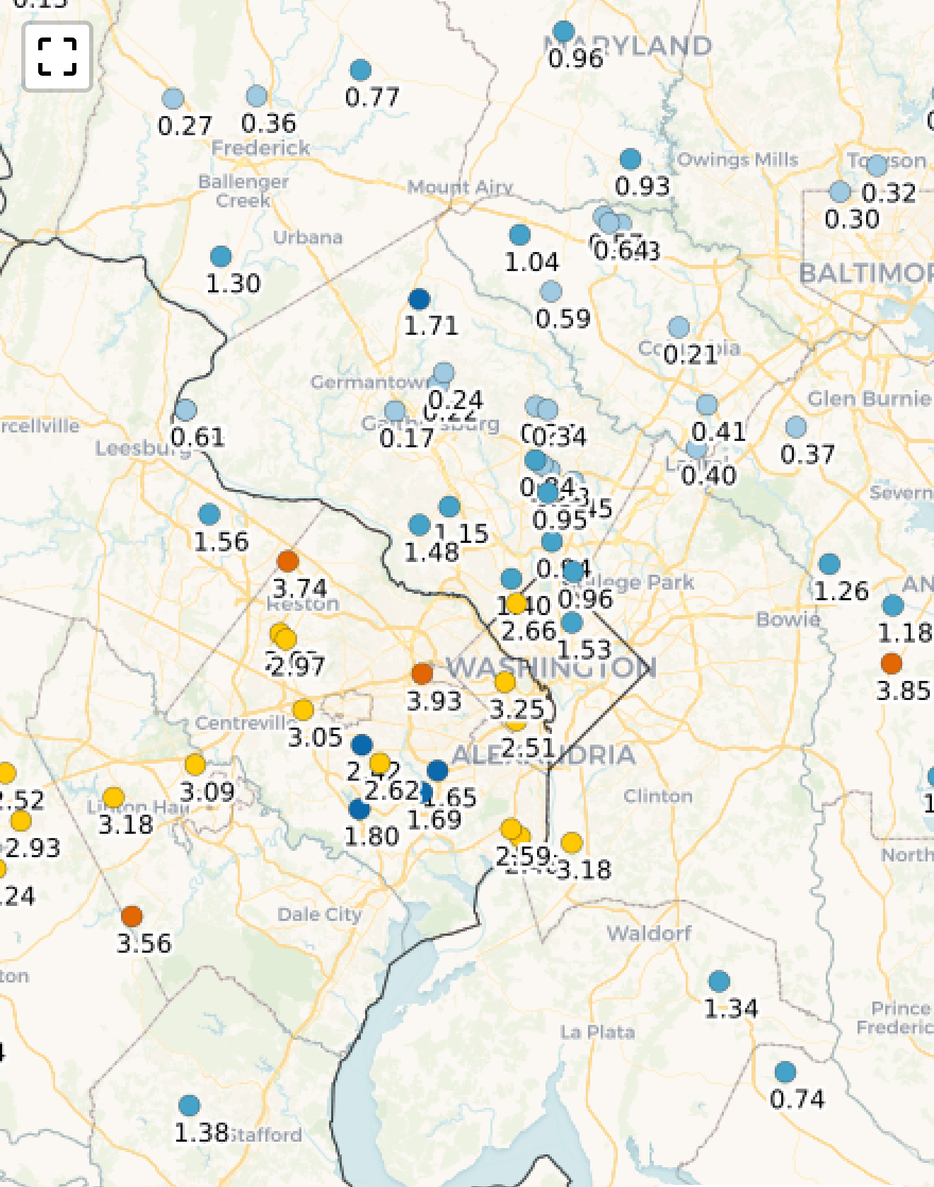
Super sharp west-to-east cutoff on last night's rain. I was right on the edge and got 0.5 with 1-2 inch amounts just north, while places close to my south got nothing. Another chance today with this juicy bit from LWX:
For now, holding off on a Flood Watch given the coverage of storms today. Still may need one in upcoming shifts especially in and around the Washington DC metro north along I-270 and back across the eastern WV Panhandle where max/mean values from the CAMS paint a solid 1-3 inches of rain with localized bullseye up to 5" -
OK we got some make up rain this morning with that back-building band that sat over central MD. Winding down now after adding 0.8 for about 1.1 total since Saturday
-
24 minutes ago, MN Transplant said:
I’m going to ignore all the places that haven’t reported yet, and radar estimates, and declare myself the three-day winner

That 1.71 at Damascus is only about 6 miles north of me (I'm close to that 0.24)

-
0.3 overnight and just 0.65 for the month, with today and tomorrow looking like the typical dreary drizzlefest with not much rain. After the wet May, maybe we're back to the <1 inch monthly totals that March and April had
-
Big cell formed yesterday like 3 miles to the east and moved away. Total for June so far just a quarter inch. Germantown is back!
July Discobs 2025
in Mid Atlantic
Posted
Radar looks like very light shower but it's solidly moderate rain coming down. Efficient rain processes? It must be pouring in central VA to southern MD