

powderfreak
-
Posts
76,984 -
Joined
-
Last visited
Content Type
Profiles
Blogs
Forums
American Weather
Media Demo
Store
Gallery
Posts posted by powderfreak
-
-
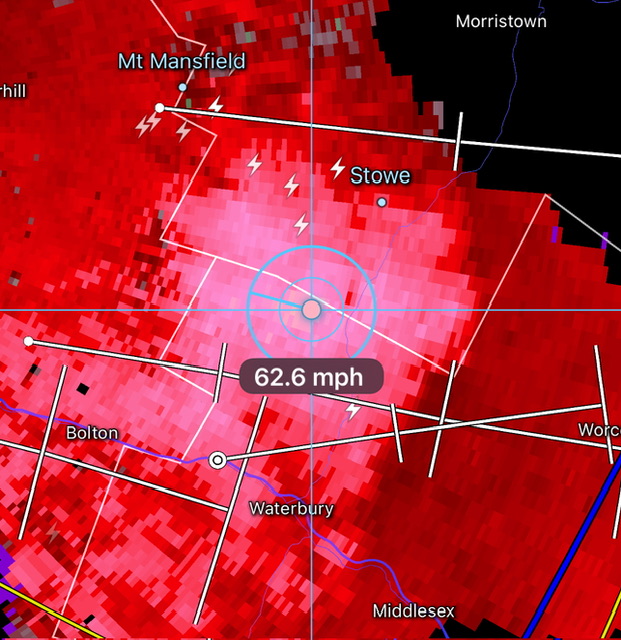
Missed the wind core by a couple miles. South side of Stowe on the county line with Waterbury got it.
-
 4
4
-
-
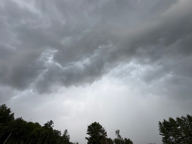
Nice shelf.
-
6
-
 1
1
-
-
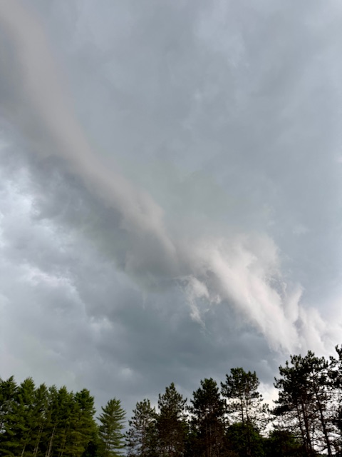
Nice bow passing through BTV…
-
3
-
-
18 minutes ago, dendrite said:
Horrible. Save that shit for Christmas.
Got about 5F rebound with some sun, but the humidity is gone for sure.
-
 1
1
-
-
Down to 63F here, dews 55F. Got chilly in a hurry.
-
3
-
 1
1
-
2
-
-
1 minute ago, Torch Tiger said:
"much worse" that made me laugh.
 It's been an 85/50-55? ish day around here for a while....COC
Maybe some storms up your way Saturday pm, NW flow. Need to see if there's anything available upstream. then Monday? You'll be closer to the front, better forcing, remnant boundaries etc.
Ha true, I was just thinking that trough could’ve been wet and cloudy… which turns 80/50 into 65/61 pretty quickly with wet-bulbing.
Any day with full sun will be nice this time of year… even lower heights it’ll mix out nicely.
-
8 minutes ago, Torch Tiger said:
This could be one of the better 4th of July weekends in recent memory. Despite the poorly-timed cool shot. Something worth considering
Yeah it heats right back up and it’s not like a cloudy/wet cool pool anyway. Sun fixes things this time of year. That trough depth could’ve led to much worse weather on Friday.
-
2
-
-
83/59 here.
Nice summer day.
-
2
-
 1
1
-
1
-
 1
1
-
-
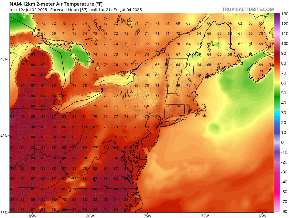
Ineedblankets getting his July 4th temperatures?
Here in the valley up north the high is 71F currently. New 12z NAM might not make it out of the 60s north and mid-70s SNE valleys under full sun?
Independence Day... Sunny, with a high near 71. Northwest wind 5 to 9 mph, with gusts as high as 20 mph.
-
1
-
 1
1
-
1
-
-
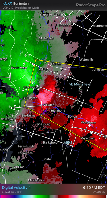
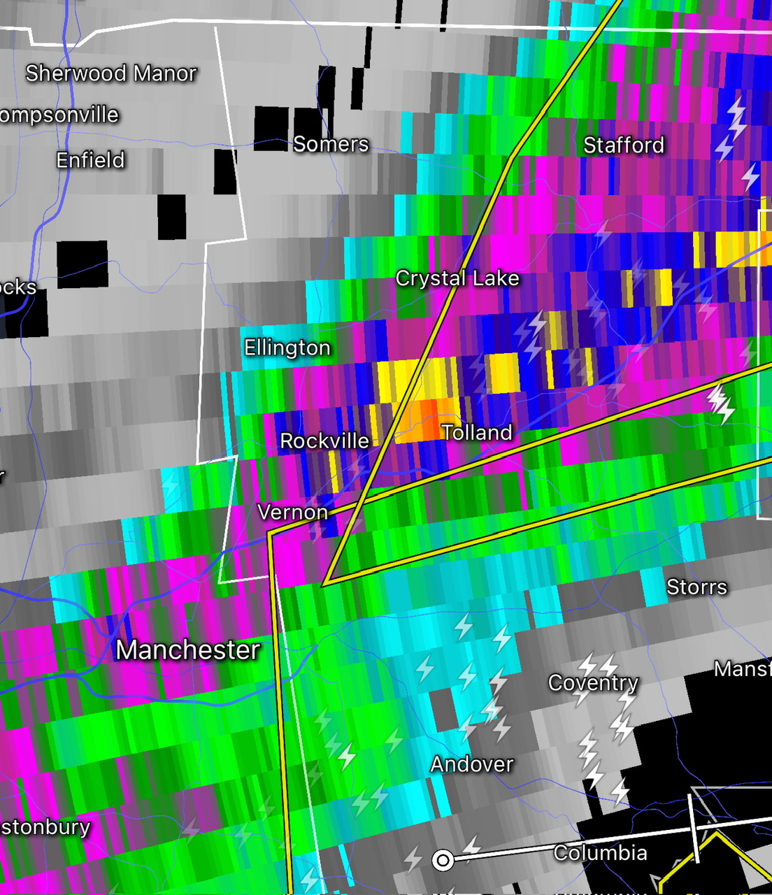
3 minutes ago, Damage In Tolland said:
2.40
That wave blossomed up into a widespread moderate rain. A lot of folks getting at least some drink down there.
-
1 minute ago, CoastalWx said:
Don’t worry I’ll catch it.
Decent Tolland jackpot.

-
1
-
-
17 minutes ago, Damage In Tolland said:
1.98 and still pouring
Webbed hands let one slip through.
-
22 minutes ago, CoastalWx said:
LOL how do you still have that?

Is that when you went on a Jebwalk around the neighborhood and your wife went looking for you, thinking you were dead in a snowbank?
-
26 minutes ago, 40/70 Benchmark said:
I love their young core...but ownership and management needs to stop getting in their owm way, and need to start adding as opposed to just switching out pieces.
Cora needs to go.
Wholesale change time. Beslow’s computer model is like the GFS. Cora has run his course. Let the young guys play.
-
2 minutes ago, 40/70 Benchmark said:
I do watch the Sox mainly for Anthony, though.
Nice to see a few multi-hit games in a row. He hits the ball hard when he does.
-
1
-
-
8 minutes ago, CoastalWx said:
Can't wait until I see more PF pics of the Gondola shrouded in snow. The excitement is palpable.
C’mon now, you don’t want to roll the dice of having 4 more months of autumn or hitting the jackpot like this?

-
1
-
-
Just now, WxWatcher007 said:
Just hit 90 here
Close here at 88F currently.
-
11 minutes ago, CoastalWx said:
LOL. I’m just kidding around.
Unfortunately I’m doing yard work but at least the kids are enjoying.
70 and hiking is definitely a good combo. Agree there.
Yeah I’m always joking around. There’s good temps for every activity. There’s a sweet spot where you can do all recreational activities and swim, like in the 80-85F range.
-
3 minutes ago, Damage In Tolland said:
It’s what is known as the hippy smell. It’s something they all use . Everytime I’m up there on business , I smell it everywhere . I’d say it’s more women than men that use it .. at least that I’ve noticed . But man it’s everywhere up there
Ahhh you are likely thinking of patchouli oil? That’s the hippy smell.
Patchouli is strongly associated with the hippie counterculture of the 1960s and 70s, where it was used to mask other odors and as a symbol of a free-spirited lifestyle.
You do smell that from time to time.
-
1
-
-
4 minutes ago, CoastalWx said:
I heard you guys spray lemon on your armpits instead of deodorant.
I take a handful of granular snow saved from winter in bags in a chest freezer, and rub that on my body every day. That’s the homemade version of Old Spice “Mountain Fresh” deodorant.
-
 4
4
-
 1
1
-
-
10 minutes ago, Damage In Tolland said:
Don’t Vermonters use incense colognes and sprays for everything though? For body (albeit terrible smelling) bug spray, hair spray , sunscreen etc?
I have zero idea what incense cologne is
.
-
1
-
-
35 minutes ago, Damage In Tolland said:
Pony O’s, Man buns and beads tucked into hoods and woven shawls on bike paths on Junorch 29th. With the heavy , sickly smell of incense perfume and colognes ..Yeah… no thanks
Yeah, it’s definitely not the hot humid sweaty smell of BO mixed with endless bug spray, while getting attacked by half a dozen deer flies in stagnant hot air, as folks try to walk, run or bike outside.
-
1
-
-
35 minutes ago, CoastalWx said:
That sounds great for April and May.
It’s really just how tied you are to water activities. At the beach, this is horrible. But really nice otherwise for just about anything else.
-
1
-
-
69F at 12pm.
Folks biking, fly fishing, running, hiking, golfing, Recreation Path looks like I-89 with traffic. No one sweating.
Swimming is likely the only activity missing.
-
2
-

July 2025 Obs/Disco ... possible historic month for heat
in New England
Posted
56/53 here with a little breeze. Windows and doors wide open and almost feels chilly.