

nj2va
-
Posts
13,606 -
Joined
-
Last visited
Content Type
Profiles
Blogs
Forums
American Weather
Media Demo
Store
Gallery
Posts posted by nj2va
-
-
3k looks sleety for a few hours before the flip to rain.
-
-
21 minutes ago, H2O said:
They’ve sprayed roads here. Where every model shows MBY getting 0.5”
I wanna talk with the dumbasses who decide these things.
Great use of tax dollars.
-
 1
1
-
-
00z GFS OP shows the potential post MLK. Looking forward to see the ensembles.
-
 3
3
-
-
30 here at home in Alexandria. 19 out at McHenry.
-
1
-
-
1 minute ago, NorthArlington101 said:
I think this is basically Tomer promising a DC/VA snowstorm?
https://x.com/burgwx/status/1743122848648958012?s=46&t=YRAxGyE8QLsoshMtJniktgOld news bro. @WxUSAF already posted it. You were too busy chasing our trace of snow Saturday.

-
1
-
-
Just now, clskinsfan said:
Just chase and dont be miserable at all. You are what 30 minutes from Westminster?
I now remember why I have him or her on ignore.
-
 2
2
-
-
Quite the Loudoun gradient. 0.5” to over 6” from SE to NW. 0.1” line runs through MBY, woo!
-
1 minute ago, TSSN+ said:
No plain rain here… I’m in
It’s amazing what cancelling winter can do for you.
-
3
-
-
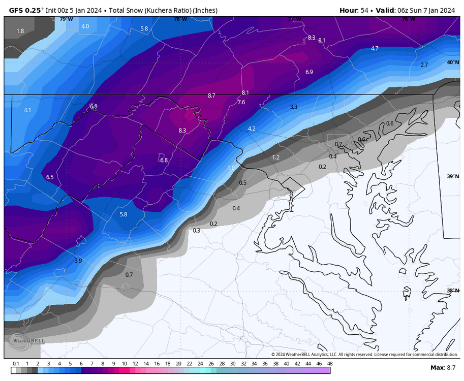
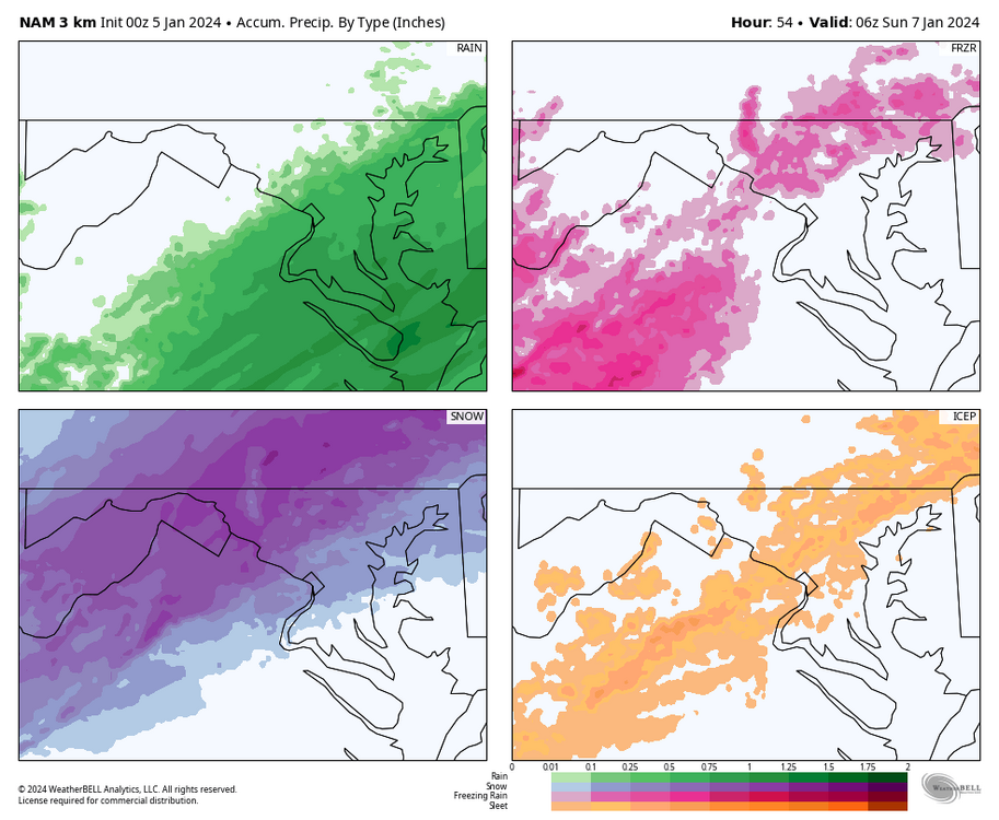
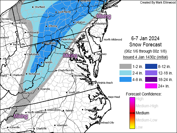
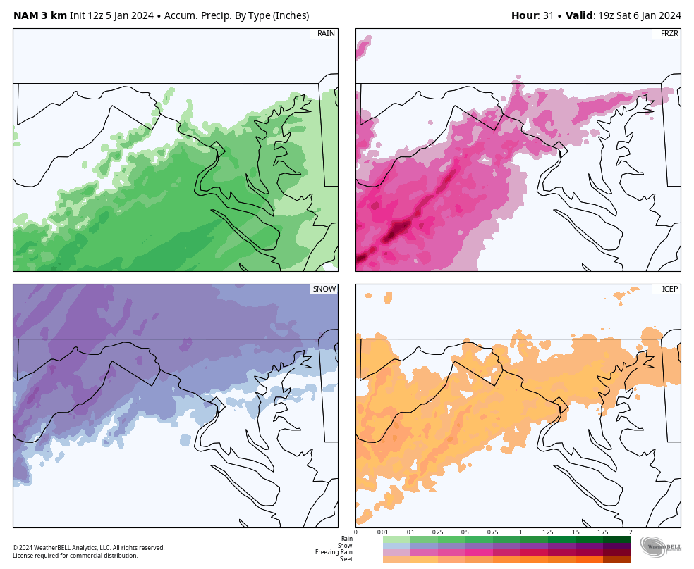
3k precip type, take the freezing rain map with a grain of salt.
-
4
-
 1
1
-
-
1 minute ago, Buddy1987 said:
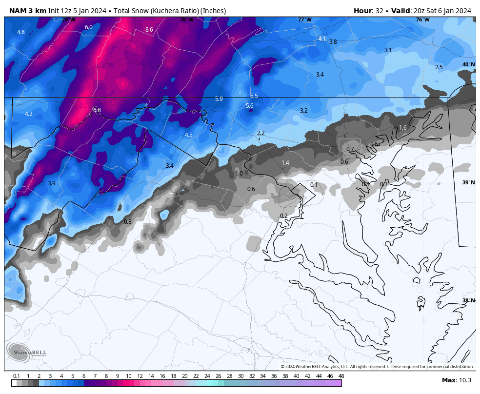
Yea def.. looked at pivotal .74 for ROA, .71 CHO area.. .30” plus Culpepper and up 81 Harrisonburg etc all smoked with ice totals.
This isn’t an ice storm setup. It’s not like it’s in the teens leading up to this and it’s drizzling for hours. I’d cut those down significantly.
-
3
-
-
2 minutes ago, Eskimo Joe said:
Winter Storm Watch extended to Carroll County.
And west to Garrett County.
-
10 minutes ago, pazzo83 said:
Well DCA is positioned to get below freezing overnight for the first time in more than 2 weeks, so that has to be a good sign right?
That’s because DCA is a joke of a recording site. I’m like a mile from there and local PWS in our neighborhood have gotten below freezing 6 times in two weeks.
-
2
-
-
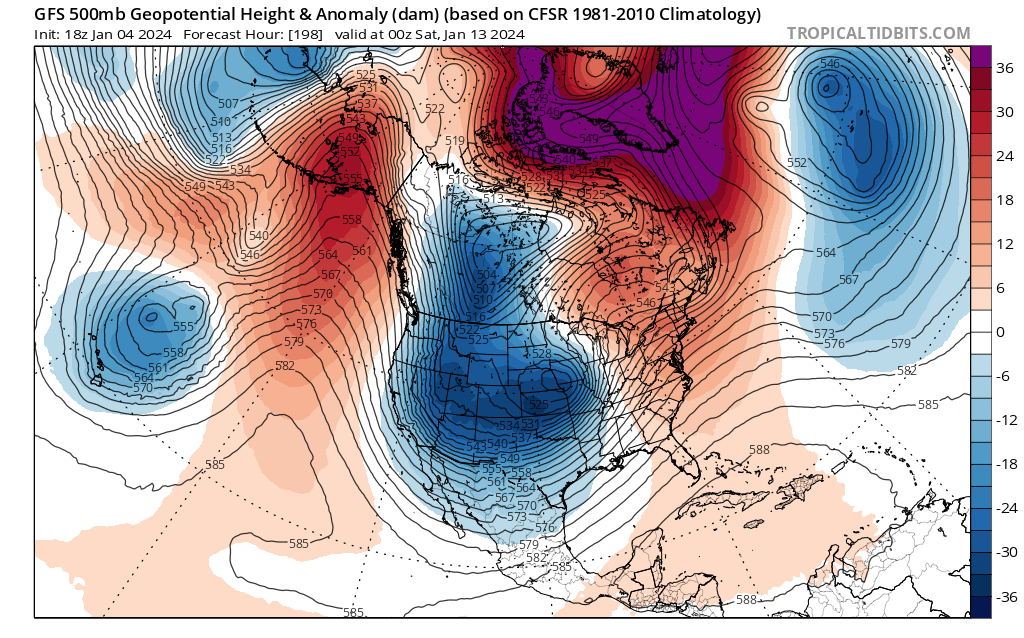
Yes, its an OP but what a gnarly west based -NAO its spitting out in the MR. Yes, I’m sure many will freak out at the surface depiction of another cutter but I’ll take my chances with a -NAO like this as we approach prime climo.
-
3
-
-
5 minutes ago, Fozz said:
Good upslope requires a stronger surface low than what this storm is offering.
MLK 2022 was a top 5 favorite storm for me - the upslope was epic for ‘part 2’ of that. Blizzard conditions at times. IIRC, you were staying in Accident or close by and chased that event right? The 500 energy that enhanced the upslope was textbook. This is definitely not that, ha.
-
8 minutes ago, umdterps29 said:
Is this the type of storm that will have upslope for the Garrett County area? If so, is the upslope intensity usually modeled pretty accurately, or is it typically more/less intense than what is shown on these models?
Garrett County may get some orographic enhancement from the LP as it’s in our area. Upslope would come on the back-end as the low is heading NE away from the area. You want to root for the follow up wave that GFS has been keying in to deepen the storm and ‘bomb’ it out for SNE. That energy as it crosses the mountains and deepens the SLP off the east coast would provide some extra lift for upslope snow showers.
18z GFS shows this scenario. Garrett County and the mountains get more snow from the upslope than the initial storm.
-
1
-
-
It’s amazing how SNE can just sneeze and back into a SECS under 100 hours.
-
2
-
-
That 2nd piece of energy (which also helped to ‘ruin’ our threat) keeps getting stronger which I think is one of the reasons why this has trended towards a big event in SNE. Too bad we couldn’t have tapped into that.
-
1
-
-
12z Euro

-
1
-
1
-
-
8 minutes ago, umdterps29 said:
What time frame is this through? Can you add through end of day Sunday if not already included? I'm curious as I'll be out at the mountain house. Thanks!
It’s free on pivotalweather. Deep Creek gets about 6” on the UK, after taking into account the stuff this morning.
-
6 minutes ago, mattie g said:
I mentioned this in the banter thread because I really don't know anything, but I'll throw it out here.
If you check the last couple days of runs, you'll that the low pops up to the north of Lake Superior. As that thing has deepened and shifted ever so slightly, our thermals have worsened. Not saying that's the only thing that's going wrong, but it can't be coincidental.
Yeah, that hasn’t helped us at all. It started showing up on ensembles the other day and clearly hurting us on the OP runs as this has gotten closer.
-
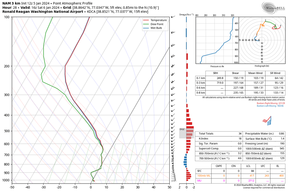
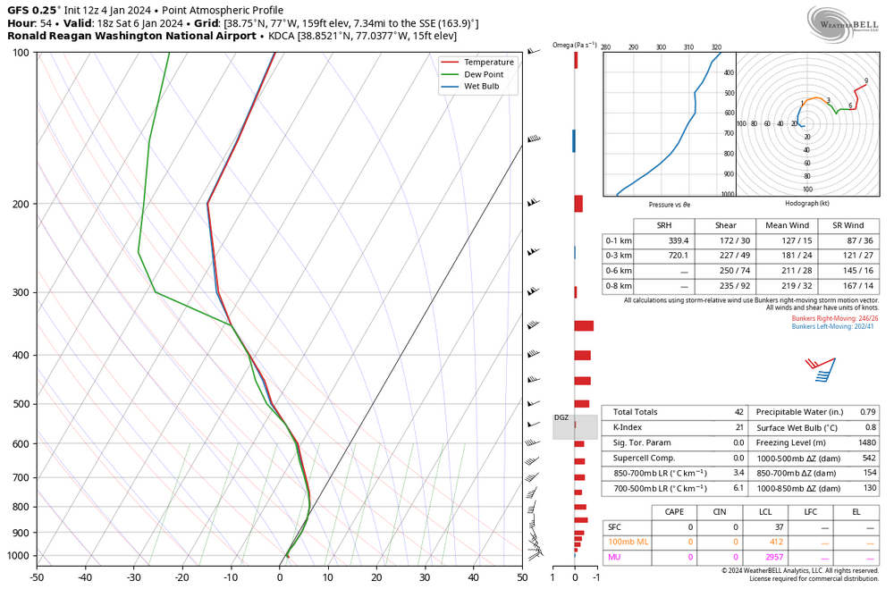
18z Saturday sounding at DCA. Super close but did get a tick colder than 6z at the same time.
-
2
-
-
It seems like somewhere between Frostburg and Hancock along 68 will be the jackpot zone for this. Models are honing in on that area.
-
4
-
-
32 minutes ago, Ellinwood said:
Been awhile...
I could see some "boom" areas in the far NW burbs of the I-95 corridor if there's heavy rates late Saturday afternoon into Saturday evening, otherwise I'm more pessimistic than optimistic. Lines up fairly well with the NWS at least from Philly southward.
Not even greyed this time


Drought
in Mid Atlantic
Posted