Benchmark
-
Posts
151 -
Joined
-
Last visited
Content Type
Profiles
Blogs
Forums
American Weather
Media Demo
Store
Gallery
Everything posted by Benchmark
-
This baby is right on my G Spot... Thing of beauty!

-
Does anyone know how far south the sleet to freezing rain switch is currently at? Is there any indication on Radarscope like we have CC for the snow to sleet hangover that we can see?
-
My friends in Brentwood just south of the city flipped to sleet at 2:09PM. Radarscope precipitation type still showing snow but correlation coefficient clearly shows the sleet line up into Nashville now.
-
Ok ATL locals can you help a Mid Atlantic member out... HRRR and MAN 3k Models showed snow staying south of ATL airport until overnight... now looking like the airport may get some snow from 12-5ish. Wife is supposed to connect through ATL getting in around 3:30 and out at 5pm. What's the chances she gets delayed or cancelled with 1-2" of fluffy snow? The alternates would cost me around $1000 to switch her airlines and airports so trying to decide to gamble or be safe.... TNX
-
You are lucky. Here in Edgewater we are rain/sleet mix right now and have been for a few hours. You must be right on the line
-
I don't know if its because I'm further east but I see more flakes than sleet right now in Edgewater along the bay... 35.2/28.8
-
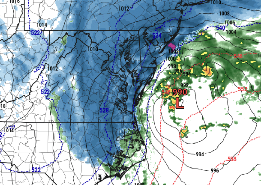
December 16-17, 2020 Winter Storm Obs/Nowcasting
Benchmark replied to WxUSAF's topic in Mid Atlantic
Very little pingers left here in Edgewater AA co along the bay... Rain rain rain :-( -
December 16-17, 2020 Winter Storm Obs/Nowcasting
Benchmark replied to WxUSAF's topic in Mid Atlantic
I am just east of PG in Edgewater along the bay and it just started here as sleet. -
Changed over to mostly sleet here in Edgewater AA Co.. ugh
-
Anyone know if the precip depiction on RadarScope is accurate? Any reports of mixing in southern MD (Calvert, Charles, St Mary’s)? I hope to stay all snow here in Edgewater but noticed big flakes mixing in recently...
-
Flakes flying in Edgewater along the bay!