

penndotguy
-
Posts
1,434 -
Joined
-
Last visited
Content Type
Profiles
Blogs
Forums
American Weather
Media Demo
Store
Gallery
Posts posted by penndotguy
-
-
Temp on the way up here 35 now with plain rain
-
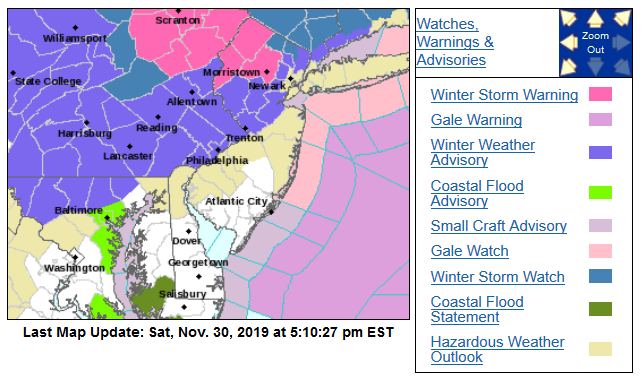
***Potentially Big Changes to Monday's Forecast***
We wanted to give you a quick update on the forecast as our latest computer guidance indicates significant changes could be in store. This could mean a much snowier forecast farther south for Monday including the Philadelphia Metro area. Here are the key points:
1) This afternoon through this evening, mainly rain will continue near and south of the I-95 corridor with mixed precipitation (sleet, freezing rain, and some snow) gradually changing to rain from south to north. However the southern Poconos and far northern New Jersey (Sussex County) should remain below freezing and continue to see mainly sleet and freezing rain. In fact ice amounts here may be higher than previously forecast...potentially up to a half inch of ice accretion.
2) Overnight Sunday night, precipitation will gradually change to all snow from northwest to southeast with the rain/snow line likely just north/west of the I-95 corridor by 7 AM Monday.
3) For Monday, this is when we could see potentially large changes to the forecast. Rain changes to snow through the morning for the I-95 corridor and the latest indications are there could be a band of moderate to heavy snow that sets up late morning through the afternoon for parts of eastern PA into northern/central New Jersey. This could include the Philadelphia metro area. This band may not be very wide but could put down 1-2 inch per hour snowfall rates for a time resulting in 4-6+ inches of snowfall accumulation for impacted areas. This could have significant impacts on the Monday afternoon/evening commute. Snow will wind down Monday night.
At this hour, we are continuing to analyze this new data and update the forecast. For the latest forecast please visit www.weather.gov/phi.
-
Just now, RedSky said:
18z NAM is a crushing for a large portion of this forum

Yeah I saw the Mt Holly post on Facebook major updates likely coming
-
16 minutes ago, Newman said:
The mesos and models now having the low stall immediately on the coast is the best case scenario for inland counties possibly including Berks. I could see the Berks area see anywhere from 0" to 6" tomorrow. The Inverted trough feature will be a nowcast event.
My temp has fallen back to 31 from 35 at 4am we have decent sleet falling
-
31 dp26 moderate sleet
-
 1
1
-
-
32 dp26 freezing drizzle, roads still good walks a little dicey in spots
-
34 dp20 with cloudy skies
-
34 dp20 with light freezing rain, Truck is glazed over and some bushes but walks and road just damp
-
31 dp25 with light sleet
-
40 minutes ago, RedSky said:
Looks like me, Kamu and Newman are the screwed on the euro
Of course it's a miller b it just might screw all
I’ll take 3” but my gut says we get screwed this time around
-
5 minutes ago, Hurricane Agnes said:
Mt. Holly lofted a WWA further south and converted the Leigh Valley Watch to a Warning...
The only warnings I saw were Poconos and NW Jersey, I know Lv had watch last night but my alert said WWA for Allentown
-
Just now, RedSky said:
Ukie wraps a 3-6" backlash band down through Bucks and kisses Philly, ECM basically has the same thing displaced 50 miles ENE.
Looks like us out here in Berks are gonna be just out side that decent wrap around as Newman pointed out to me earlier. It’s early just having these threats is encouraging
-
2
-
-
So it’s not a true Miller b? Have we ever had this setup before? And seems like there could be some serious changes as it unfolds.
-
2
-
-
WSW just north Berks not included yet
-
Moderate snow grassy areas covered road is slushy, numerous accidents rt183 north of 78, bit of a surprise
-
definitely my all time favorite
-
1
-
-
20 hours ago, Rtd208 said:
It has been pretty dry and uneventful here the last 30 days or so. Eventually the pendulum is going to swing the other way and when it does it will hopefully take us through the rest of the fall and winter months.
Im in for a warmish event free October then November on it can start getting colder as long as no snow till after Thanksgiving then let the games begin.
-
 1
1
-
-
I VOTE NO, at least here its pretty laid back and if anyone wants to sort through all the riff raff that goes on over there they can. I don't post a lot just Obs during the winter. Just my .02
-
2
-
-
Just had a EAS Flood warning again, so far they are 3 for 3 out here we'll see if it happens again, This is crazy
-
looking at the radar that storm the other side of 81 just North of Lebanon Pa looks nasty
-
86 and mostly sunny here, not looking forward to anymore drenching rain we've had enough.
-
16 minutes ago, Newman said:
Storms coming in from the west forming a nice bowing line segment. Much of the area should be impacted through the rest of the afternoon, especially the further west you go.

Yup warnings just issued for Berks 60mph winds quarter size possible.
-
90 Dp74 its sticky out there, storms look to be lining up to the West
-
Storm incoming, very heavy rain at the moment

Coastal Storm Dec 1-2
in Philadelphia Region
Posted
I don't envy the folks at Mt Holly on this forecast, everything last night looked pretty good but 12 hrs later it may end up being a bust for a lot of the region. Never really looked that good for my area (Berks) anyway, I guess until that Low develops we'll have some idea?
34 dp-33 with cloudy skies